Thursday June 7th… Dear Diary. The main purpose of this ongoing post will be to track United States extreme or record temperatures related to climate change. Any reports I see of ETs will be listed below the main topic of the day. I’ll refer to extreme or record temperatures as ETs (not extraterrestrials)😊. Here is today’s main climate change related hot topic:
New Tropical Findings
A new study refining the ramifications of carbon pollution concerning tropical solutions has come out this week. Apparently hurricanes are starting to move slower, which means higher winds, storm surge, and heavy rain over a given area longer than systems in prior decades. I’m going to put these new tropical findings in my “how bad how soon” file. Any nuanced scientific findings concerning different regions on the planet or specific weather will help planner’s adaptation efforts. I saw many articles, which I will link on this post, on new tropical findings.
First, here is the NOAA article on slower moving hurricanes:
https://www.ncei.noaa.gov/news/tropical-cyclone-slowdown
Quoting frim the article:
Tropical cyclones—also sometimes referred to as hurricanes and typhoons—are taking substantially longer to move from place to place, according to a new study by NCEI scientist Jim Kossin. In his paper, “A Global Slowdown of Tropical Cyclone Translation Speed (link is external),” published in Nature, Kossin demonstrates that, globally, tropical cyclones slowed by 10 percent between 1949 and 2016. With additional water vapor in the atmosphere in a warming world, as little as a 10 percent slowdown could double local rainfall and flooding impacts caused by 1°C of warming.
According to the study, tropical cyclones have slowed in both hemispheres and in every ocean basin except the Northern Indian Ocean. But, tropical cyclones have generally slowed more in the Northern Hemisphere, where more of these storms typically occur each year. Regionally, the western North Pacific Ocean has seen the most slowing at 20 percent, followed by the region around Australia at 15 percent.

Last year Harvey was the poster child for slowing hurricane trends dumping extreme record rain on the Houston/eastern coastal Texas area. In a nutshell, weakening meteorological upper air steering currents were to blame. As the atmosphere warms more ridging or heat domes occur trapping or holding organized tropical systems in place, thus the statistical slowdown found by researchers.
Here is Dr. Jeff Master’s take in the slowing findings:
Quoting from this article:
“Global warming theory calls for summertime winds in the tropics to decrease. Thus, we should expect to see a slow-down in the translation speed of hurricanes in a warmer climate, due to weaker winds pushing the storms along. The observed 10 percent global slowdown occurred in a period when the planet warmed by 0.5°C, so it is plausible to ascribe the slowdown to global warming. It is uncertain if the observed 10% decrease in translation speed since 1949 can be entirely ascribed to human-caused global warming, though, since Kossin did not attempt that kind of attribution study. Also, the paper did not answer the question of why the trends in translation speed varied between ocean basins and on land versus over the water.”
Here is the New York Times right up for comparison:
https://www.nytimes.com/2018/06/06/climate/slow-hurricanes.html
Segueing from slowing tropical systems from the New York Times piece to another aspect of tropical systems:
“A growing body of research is showing that hurricanes are becoming more dangerous. A recent analysis by noted climate scientists, though not a peer-reviewed study, suggested that even as the winds that move hurricanes along are getting weaker, the winds inside hurricanes are getting stronger.”
Dr. Michael Mann and his colleagues have found evidence that hurricane winds are getting more fierce. I’ve noticed over my lifetime systems from Hugo to Andrew to Katrina to Irma appearing to get stronger with time, but I could not empirically prove it. Others have as evidenced by this recent Real Climate discussion:
Again, this makes logical sense because in a warming world due to both increased latent heat in the seas and in the atmosphere simple physics would indicate that any organized tropical system would potentially have the opportunity to attain higher winds, and I would argue with faster ramp up times. Directly from the Real Climate article:
One consequence of this increase is that in most major tropical cyclone regions, the storms with the highest wind speeds on record have been observed in recent years (see Fig. 1 based on reanalysis by Velden et al. 2017). The strongest globally was Patricia (2015), which topped the previous record holder Haiyan (2013).
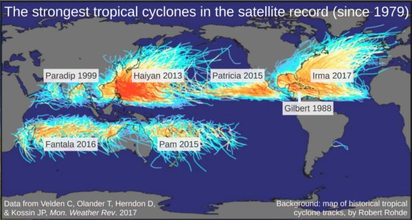
Fig. 1 The strongest storms for the major storm regions Western and Eastern North Pacific, North Indian, South Indian and South Pacific, Caribbean/Gulf of Mexico and open North Atlantic. Of these seven regions, five had the strongest storm on record in the past five years, which would be extremely unlikely just by chance. Irma was added by personal communication from Chris Velden, and a tie of two storms with equally strong winds in the South Indian was resolved by selecting the storm with the lower central pressure (Fantala). (Graph by Stefan Rahmstorf, background image from Robert Rohde, Creative Commons License CC BY-SA 3.0.)
Yeah the old eyes of the Climate Guy were not deceiving him after the turn of the century.😉 As more studies appear on the subject of climate change and the tropics I’ll definitely bring them to everyone’s attention.
…………………………………………………………………………………………………
Speaking of the tropics the GFS has been consistent the last few model runs on forecasting a system to develop similar to near Alberto’s origin and on about the same path next week within my 240 hour rule of thumb non garbage model time frame:

The European model does not develop a system in the Atlantic. We will see if we have a tropical storm or hurricane in the Gulf by Wednesday or Thursday of next week.
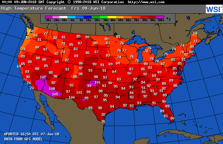
As far as heat wave #3 goes temperatures will be warming into the 90s in the central Plains, but remain below record values except perhaps in scorching west Texas and Oklahoma on Friday:
(If you like these posts and my work please contribute via the PayPal widget, which has recently been added to this site. Thanks in advance for any support.)
The Climate Guy