Tuesday October 9th… Dear Diary. The main purpose of this ongoing post will be to track United States extreme or record temperatures related to climate change. Any reports I see of ETs will be listed below the main topic of the day. I’ll refer to extreme or record temperatures as ETs (not extraterrestrials)😊. Here is today’s main climate change related topic:
Tracking Michael Day Three
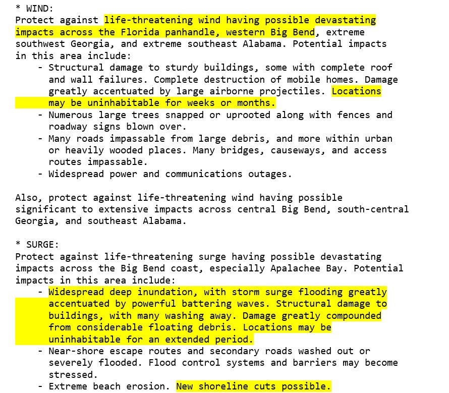
*Big note: Hugo and Opal flattened trees for hundreds of miles inland after they made landfall. I expect Michael to do the same.*
This evening, unfortunately, Michael may very well be on its way to minimal CAT 4 status. We will know more by 11 PM EDT.
…………………………………………………………………………………….
From this morning:
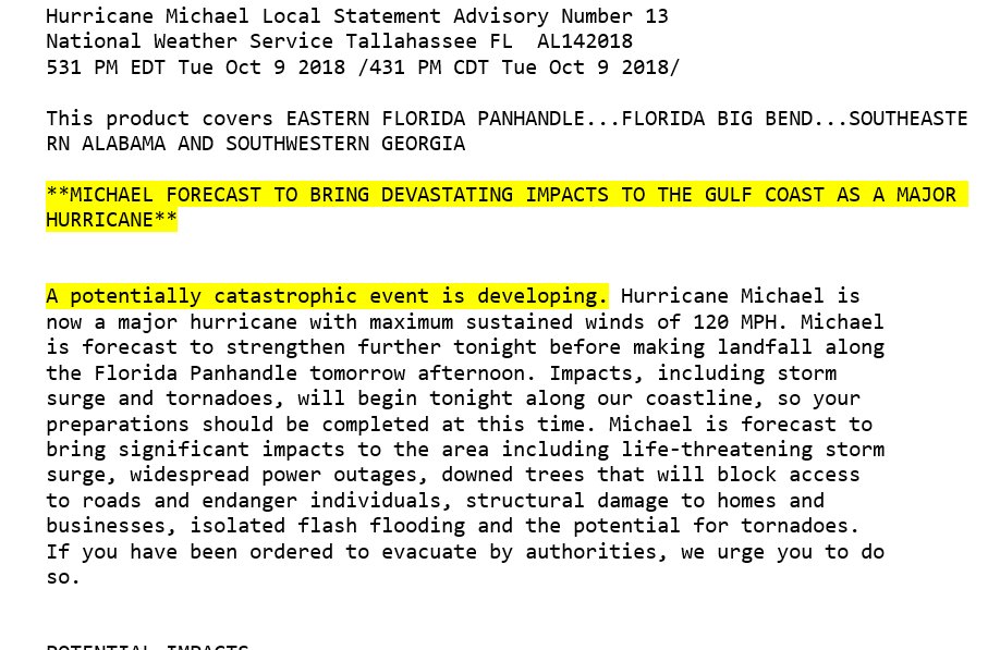
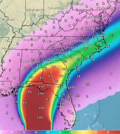
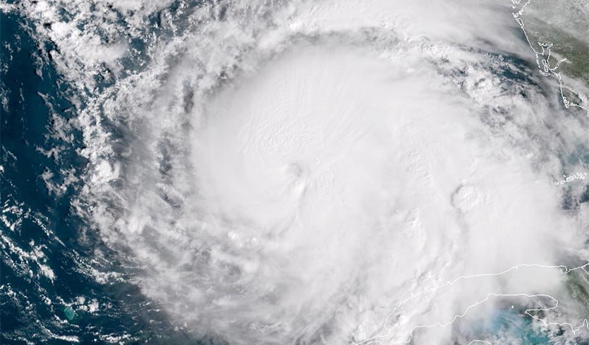
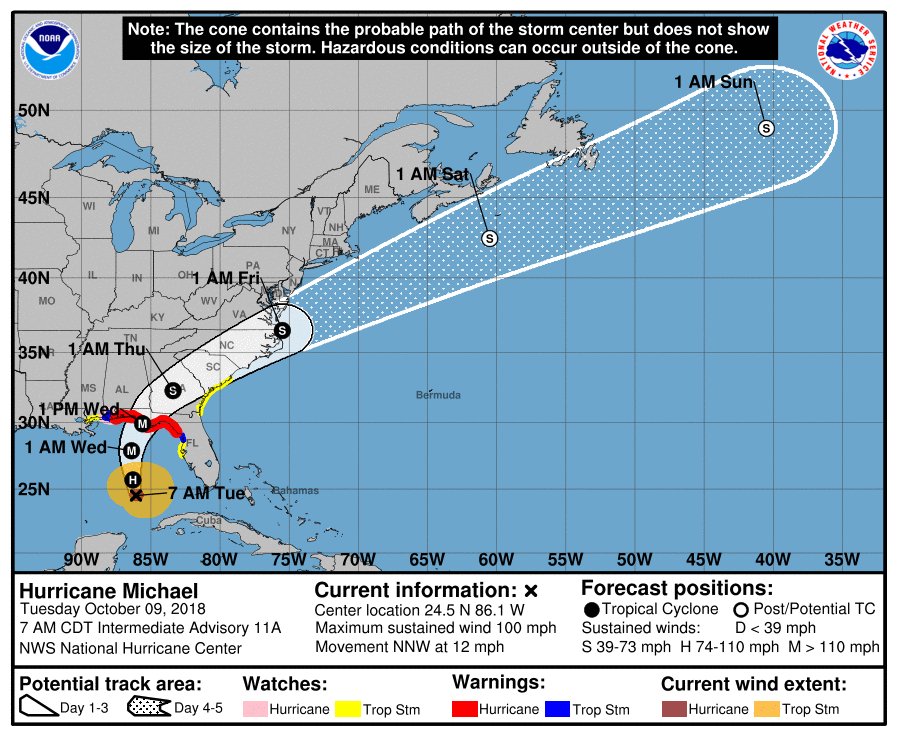
Well ladies and gents, unfortunately I can’t write good news about Michael, which as of this morning is well on its way to becoming a deadly CAT 3 hurricane with winds over 110 mph. The current forecast is for a landfall in the Florida Panhandle with maximum sustained winds of 125 mph. Such winds would cause massive destruction well inland along Michael path. It looks like damage from Michael will be much worse than that of Florence given the current forecast and track. Yesterday I wrote extensively about climate change related factors that may make Michael more deadly. Nothing has changed today: https://guyonclimate.com/2018/10/08/extreme-temperature-diary-october-8-2018-topic-tracking-michael-day-two/
The only item I might add is expect very strong hurricanes in the future due to climate change, but as some studies have shown, not necessarily more of them in the Atlantic Basin.
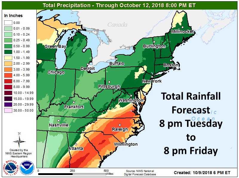
Also from yesterday, it appears that Michael will behave much like Opal from October 1995 due to its relatively fast movement once the system makes landfall and strength. Michael should move through the Southeast like a buzz saw from about Panama City through central and south Georgia through areas already hard hit by Florence in the Carolinas to about Norfolk, Virginia before moving back off the coast. Expect widespread tree and power line damage along this path. I’ll emphasize here that met models have not deviated one iota from the scenario I wrote about yesterday, remaining very consistent.
About all that remains for me to do on today’s post is just to report expert’s analysis, so here is what I’m seeing on social media. Today I will list the newest items at the top of this post with older ones kept near the end. So here we go:
(As usual, this will be a fluid post in which more information gets added during the day as it crosses my radar, crediting all who have put it on-line. Items will be archived on this site for posterity.)

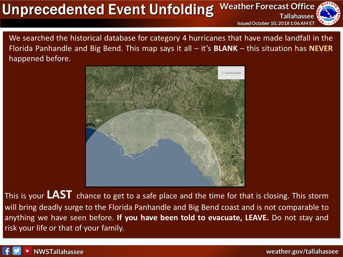
If you live along the coast and were told to evacuate…this is YOUR LAST CHANCE. Hurricane Michael is an unprecedented event and cannot be compared to any of our previous events. Do not risk your life, leave NOW if you were told to do so.

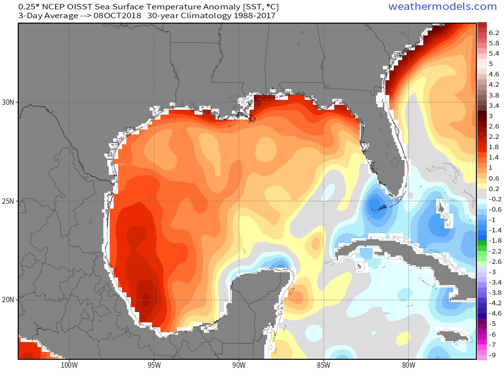
Sea surface temperatures in the Gulf of Mexico will not be a limiting factor for #HurricaneMichael’s ability to continue intensifying prior to landfall. Unfortunately, I just don’t see any factors (like wind shear or dry air intrusion) that could significantly weaken #Michael.
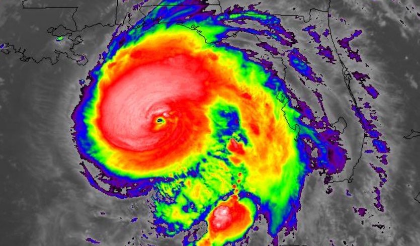
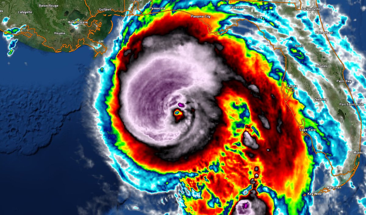
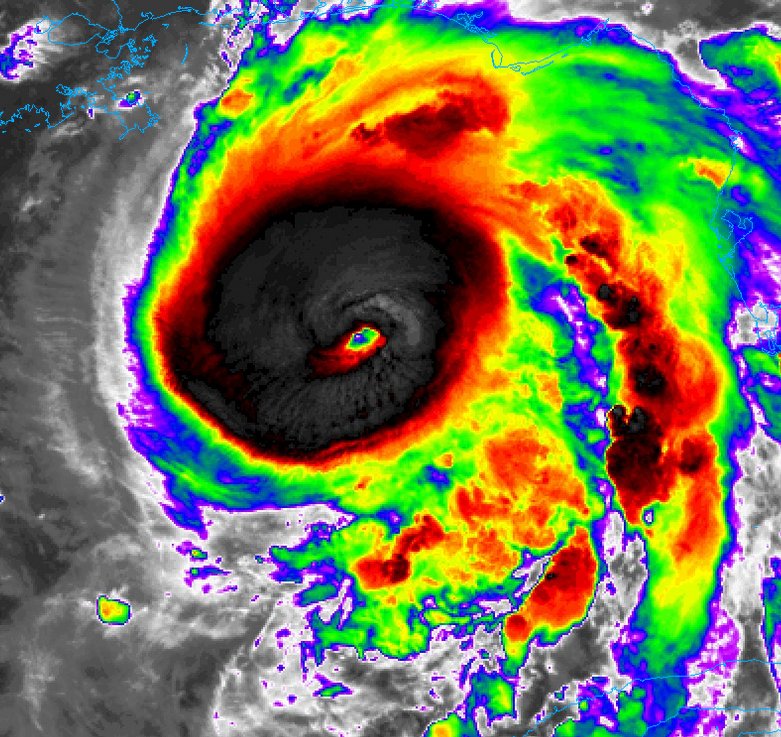
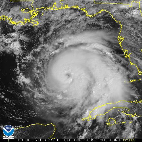
This is a current 2 kilometer IR GIF of Hurricane Michael, and is projected to strengthen to a CAT 4 later today. Life threatening storm surge & Hurricane force winds with heavy rainfall expected along the Northeastern Gulf Coast. Be prepared https://t.co/Fqz7qfitAh … pic.twitter.com/KUeBo0PVSK
— Scott Cook (@scook2214) October 10, 2018

Heads up: Florida’s entire Gulf Coast north of Punta Gorda has never recorded a Category 4 hurricane landfall. #Michael is now predicted to reach Cat 4 strength just before it hits the FL Panhandle https://bit.ly/2ONg21O

Latest advisory from @NHC_Atlantic shows #Michael getting stronger. Landfall expected on the Florida Panhandle Wednesday PM. We’ll have overnight coverage on @weatherchannel Join me and @TWCRayStagich 1am-5am EDT

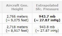
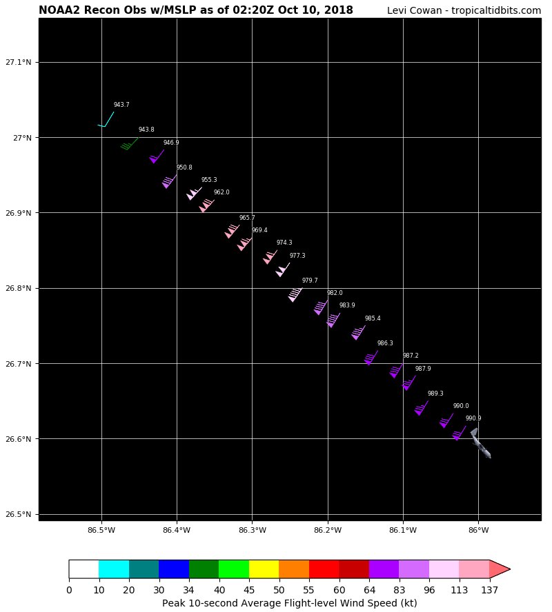
Data from recon indicates that #Michael continues to steadily intensify. Extrapolated surface pressure are all the way down to 943.7mb with 110 knot winds in the NW quadrant. This is an extremely dangerous situation.
Here we go again. Take a look at the last 30 years of development in Destin, FL, which is located on a barrier island. pic.twitter.com/6uu0Iwyw4j
— Walker Ashley (@WalkerSAshley) October 9, 2018

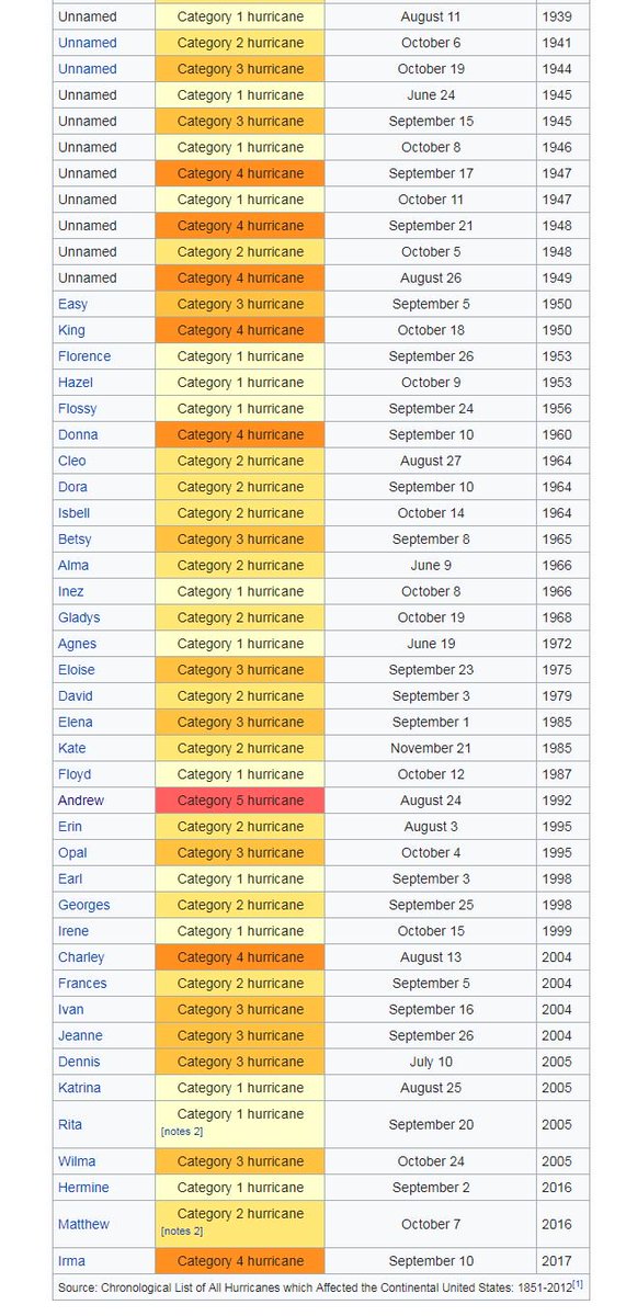
#HurricaneMichael expected to be Cat 4 at landfall. #Florida has been hit by 10 Cat 4 in its recorded history and 2 Cat 5’s but none of these were in the Panhandle.
This is the first time all day that we've seen #Michael have a symmetric cloud canopy without a bursting pattern. GLM continues to pick up on a significant amount of lightning in the NE quadrant. pic.twitter.com/4fBUpYh6GU
— Steve Copertino (@TheSteveCop) October 9, 2018

.@parkertwc takes a deeper look at the storm surge threat from Hurricane #Michael and what it might look like: pic.twitter.com/9VEXpAiBxZ
— The Weather Channel (@weatherchannel) October 10, 2018
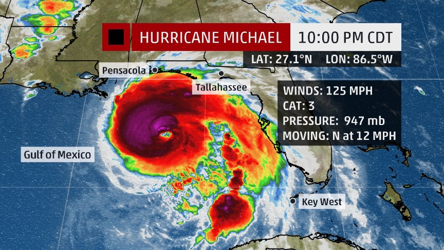
Recon is measuring the strongest winds yet in #Michael, about 125 mph at the surface. Michael continues to strengthen quickly this evening.


Usually not a good thing when a major hurricane gets that “buzz saw” look… #Michael

Tropical Storm Watches & Warnings and Flash Flood Watches have been issued for parts of Georgia, South Carolina and North Carolina. While Michael will be weakening and speeding up after moving inland, impacts will continue until the storm moves away from the East Coast late Fri.
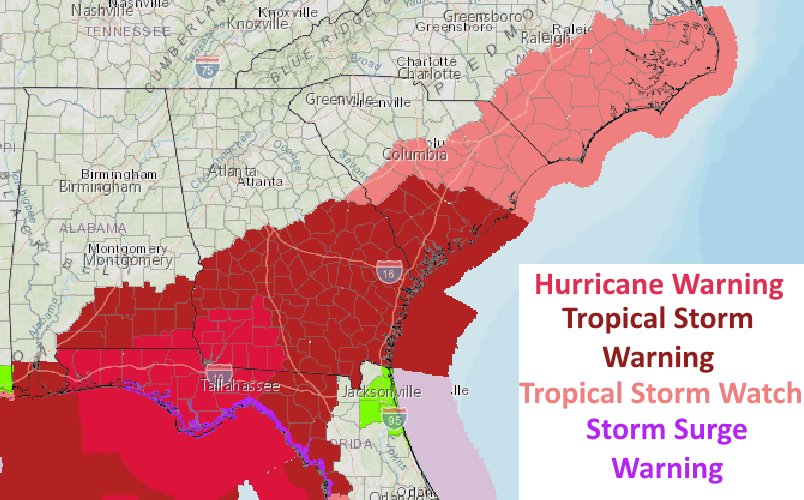
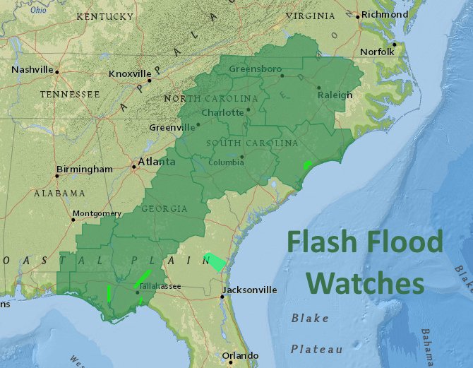

#Alabama, #Georgia, #SouthCarolina, and #NorthCarolina: just because #Michael is going to make landfall in #Florida doesn’t mean it ends there. Tropical storm conditions likely across long swath as the storm exits, and even chance of hurricane-force winds in coastal SC and NC.

Upgraded to Category 3 #HurricaneMichael with 120 mph winds and still time to strengthen even more…it is what we as meteorologists have warned about all week. Florida and South Georgia, Southeast Alabama…THIS…IS…NOT…A…DRILL

Eye of #Michael clearing out as additional intensification is forecast. Cannot rule out a cat 4 at landfall, but at least cat 3 expected. Weather will deteriorate on FL Gulf Coast tonight, long before center crosses coast tomorrow. Get to your safe shelter inland by tonight! pic.twitter.com/wIXQyeyyOa
— Dr. Rick Knabb (@DrRickKnabb) October 9, 2018
Thanks @BMcNoldy NOAA Hurricane Threats and Impacts (HTI) graphics operational in June 2015 ..So much more effective than Category focus ….found here #HurricaneMichael #Michael https://www.weather.gov/srh/tropicalor https://digital.weather.gov/ .

Now a high-end Category 2 hurricane, #Michael is expected to reach the FL Panhandle as a strong Cat 3 on Wednesday, then race across the Southeast U.S. with tree-toppling winds and heavy rain https://bit.ly/2ypq3Ik

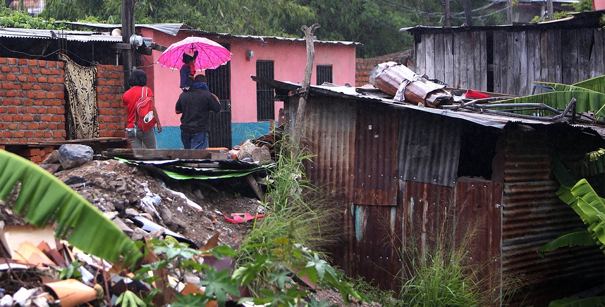
The tropical disturbance that eventually formed into #Michael brought flooding to Central America, leaving at least 13 dead: https://wxch.nl/2Qyz6xZ
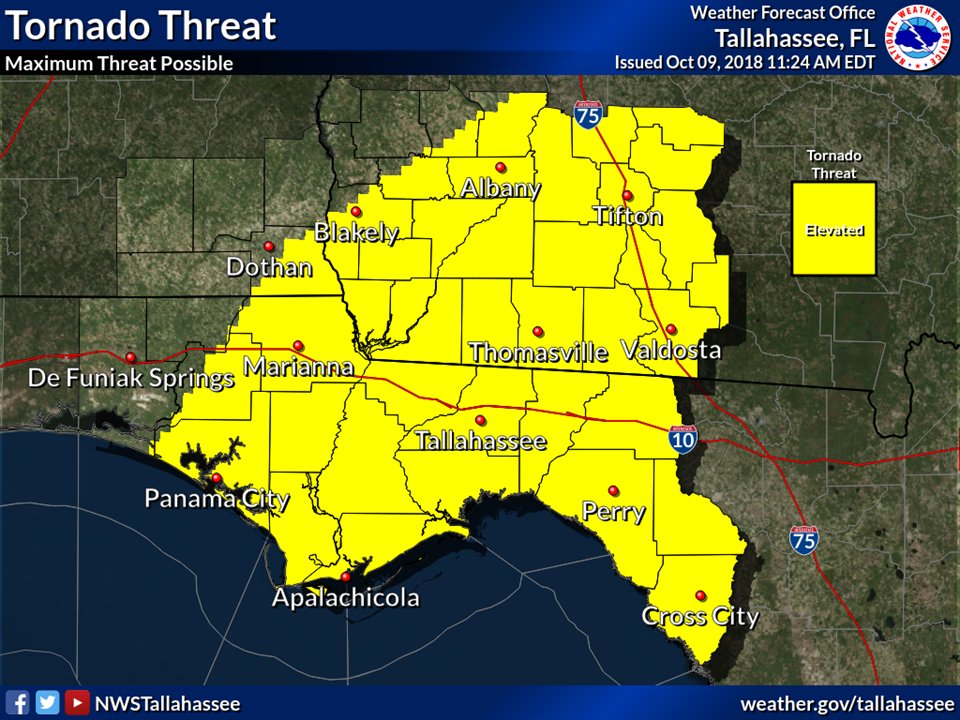
There will be a tornado threat. As with most tropical systems, there is always a risk for tornadoes. Please stay tuned to current conditions have an action plan if under a tornado warning. Find the lowest room in your house with the most walls protecting you from the outside.
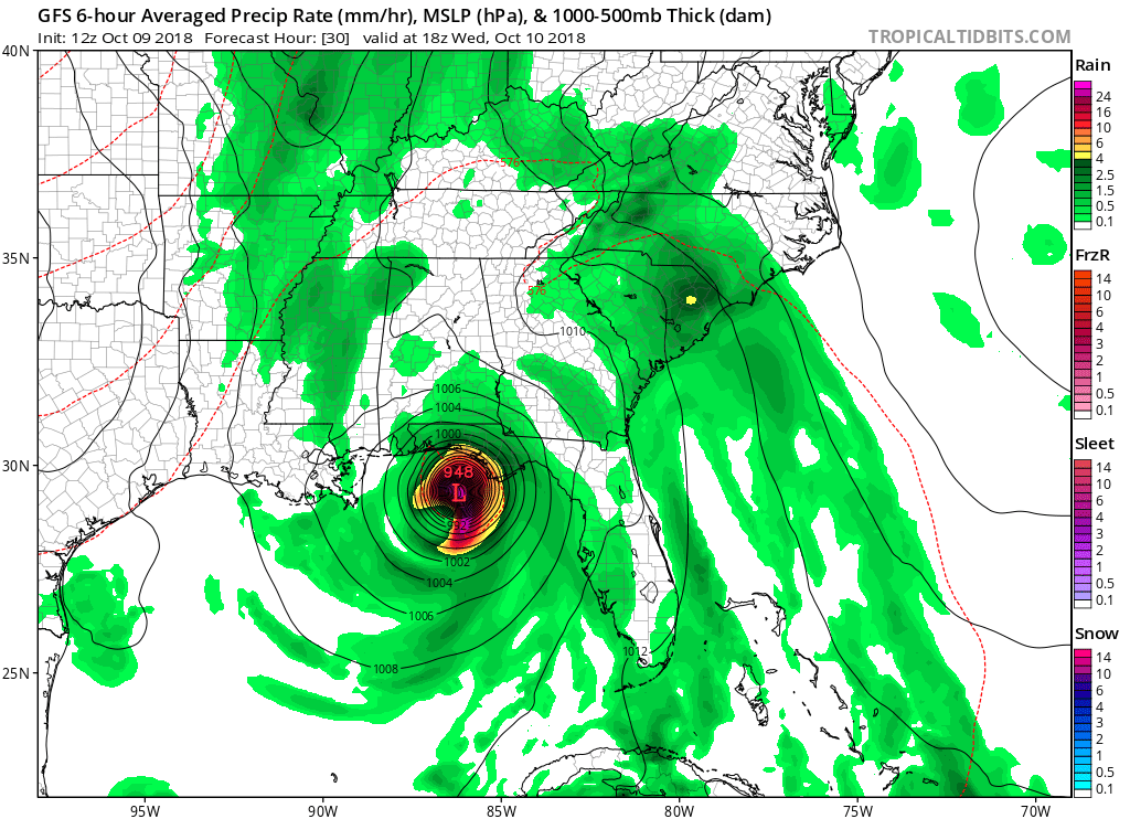
GFS model 10 day forecast W. Atlantic 10/9 12 pm
Hurricane Michael center is NW of Cuba, and moves North over the Gulf becoming a CAT 3 hurricane & making landfall on the W FL Panhandle. It moves NE through the SE U.S as a strong subtropical storm before moving off the SC coast. pic.twitter.com/hlOBYJZ9dX— Scott Cook (@scook2214) October 9, 2018
GA declares State of Emergency. I find that many have 0 idea what this actually means. As my emergency management colleague Claude Craig points out “This does not mean to panic. This enables the state to allocate resources and lessen restrictions in the declared areas.” #gawx

It appears that westerly mid level wind shear continues to impact #Michael today. However, some of the most impressive convection is now located upshear of the storms center, suggesting the system may continue to gradually strengthen. Mid level shear is also forecast to weaken. pic.twitter.com/XIN0pp6iS9
— John Homenuk (@jhomenuk) October 9, 2018
The 12Z GFS has Michael at CAT 3 strength at landfall near Panama City late Wednesday afternoon:

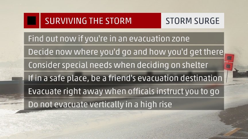
If you live in a coastal high rise and have been told to evacuate, do not “vertically evacuate”. Winds get even stronger the higher you go up, debris will fly into windows, and if you survive you’ll be isolated in a flooded community without power, and help can’t come. #Michael
Don’t assume #Michael will be just like Dennis 2005, Opal 1995, or Eloise 1975, recent majors to make landfall on Florida Panhandle. Every storm is different. This one could come ashore farther east and be worse for places that didn’t receive full brunt of previous ones.

The latest #HurricaneMichael advisory from @NHC_Atlantic. Sustained winds now 100mph with a gradual movement northwestward at 12 mph. Landfall likely by early Wednesday afternoon along the Florida panhandle with impacts beginning across portions of #NCwx as early as Wed night.
In other weather and climate news:

From yesterday’s IPCC report: Immediate and sweeping cuts in greenhouse gas emissions are required to limit planetary warming below 2.7°F (1.5°C). From NOAA: The U.S. just had its 4th warmest September on record.


Meanwhile in #Miami today…
#SunnyDayFloods due to the #KingTides and #SeaLevelRise
image via @kenrussellmiami

(If you like these posts and my work please contribute via the PayPal widget, which has recently been added to this site. Thanks in advance for any support.)
The Climate Guy