Thursday November 1st… Dear Diary. The main purpose of this ongoing post will be to track United States extreme or record temperatures related to climate change. Any reports I see of ETs will be listed below the main topic of the day. I’ll refer to extreme or record temperatures as ETs (not extraterrestrials)😊.
Potpourri Of October Climatology
Welcome to November everyone. It’s the first of the month so it is time to post incoming climatology messages issued by various agencies across the planet, with an emphasis on what happened across North America for October 2018. Despite the overall warmth of the planet due to carbon pollution there were various cold pockets with below long term temperature averages.
As far as the United States goes, Radiant Solutions posted these summaries today:

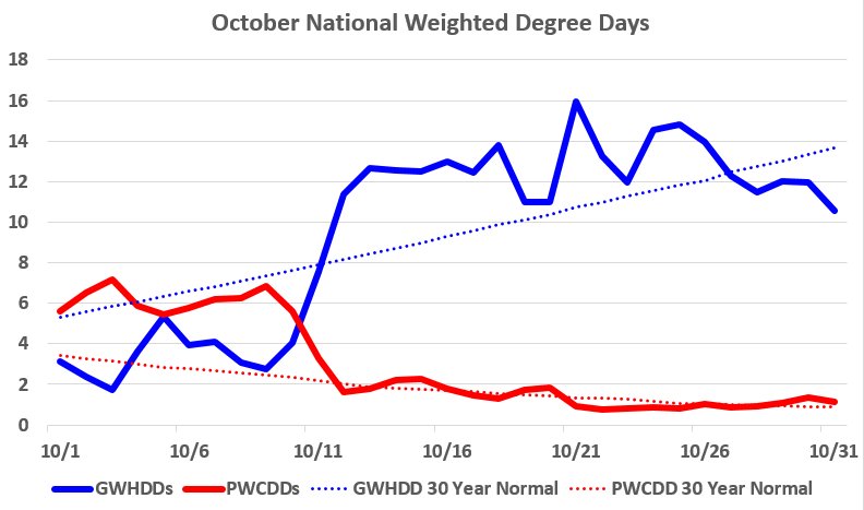
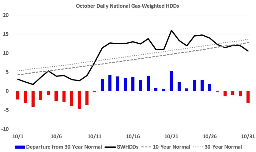
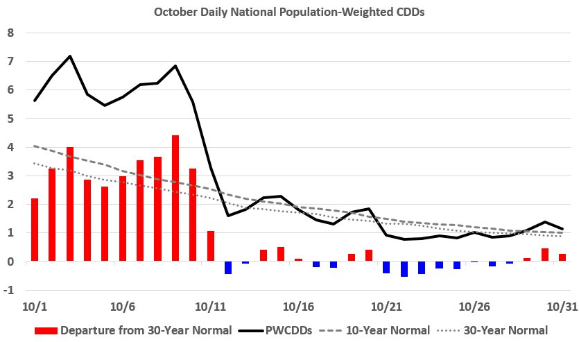
It’s hard to describe October simply using monthly WDDs. If you look only at PWCDDs (2nd highest since 1950) you’d think “wow what a warm month.” If you only look at GWHDDs (25th highest since 1950, 1st above normal since 2009) you’d think “wow what a chilly month.”
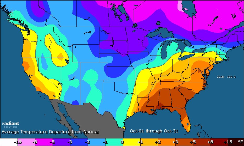
Basically we ended up with a near average month in the state for temperatures with above average warmth in both coasts and chilly conditions occurring for the bulk of the central CONUS. The well above average warmth in the Southeast enabled Michael to become an extremely powerful, deadly hurricane for the Panhandle of Florida and South Georgia early in the month.
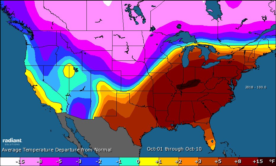
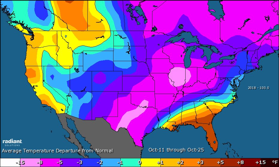
As October 2018 progressed, though, it go much warmer in the West, and we saw a cooling trend in the East:
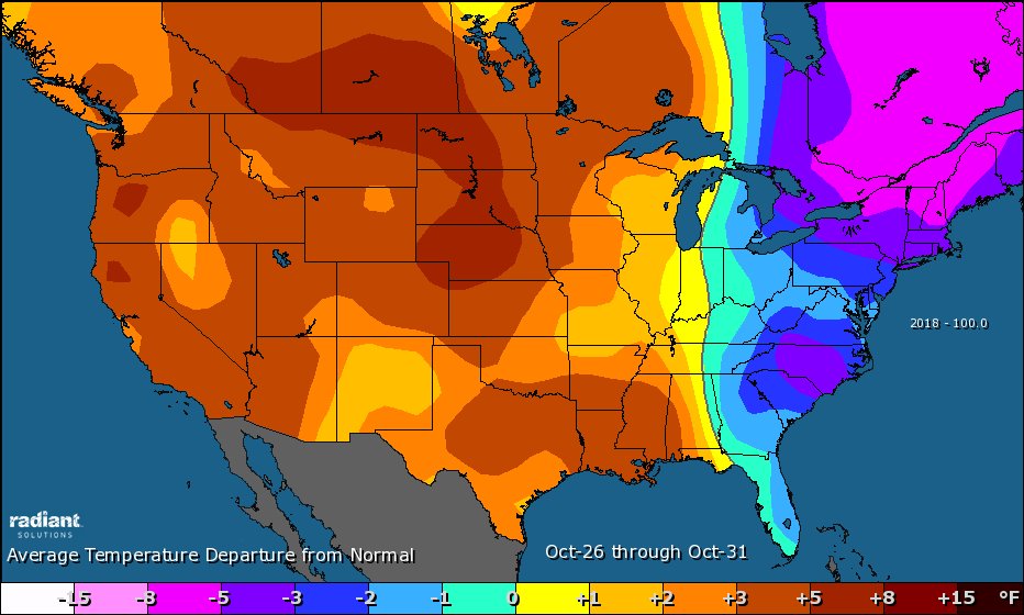
Oct 1-10 had nearly double PWCDDs 61.3 than GWHDDs (34.0) as the eastern half saw impressive warmth. Then, a two-week period of chill was seen from Oct 11-25, with the GWHDD total of 188.3 ranking 8th-highest since 1950 for that period. Things then ended warmer Oct 26-31.
Cooler than average conditions in the southern Plains was also accompanied by very wet weather. Dallas was near ground zero for some very heavy inundations:
To put Dallas' crazy wet Sept.-Oct. in perspective: 39 of Dallas' 119 years of record (~33%) had less rain in the entire year than the 28.35" measured this September and October, most recently 2014 (21.32"). pic.twitter.com/nUsifsp0xz
— Radiant Solutions | Weather Desk (@Radiant_Weather) November 1, 2018
Our big neighbor to the north stayed cool since the dipole trapped cold air aloft and at tge surface over most of Canada:
October 2018 gives us another anomaly map full of blue across #Canada. #Kapuskasing, ON even got its coldest October on record (since 1937)! The exception is in the NW from Whitehorse to Alert, with a very warm October over there. #ONwx #WxTwitter pic.twitter.com/kF50FKs4uv
— Patrick Duplessis (@Pat_wx) November 1, 2018
We’ve been keeping an eye on Barrow Alaska where exceptional warmth has been occurring the last few years:
Utqiaġvik (Barrow), Alaska average temperature in October of 25.7F (-3.5C) is third highest in the past 99 years. The complete lack of cold Octobers after 2001 tied to collapse of Chukchi Sea autumn sea ice. #akwx #Arctic @Climatologist49 @IARC_Alaska @CinderBDT907 @vennkoenig pic.twitter.com/elHjkgINId
— Rick Thoman (@AlaskaWx) November 1, 2018
During October Alaska had exceptional above average warmth:
These Alaskan communities just finished their mildest Octobers of record:
Anchorage: 44.8F (7.1C)
Bethel 41.0F (5.0C)
King Salmon 44.5F (6.9C)
Nome: 38.4F (3.6C)
Yakutat: 46.5F (8.1C)#akwx #Arctic @Climatologist49 #NotNormal— Rick Thoman (@AlaskaWx) November 1, 2018
October was exceptionally warm all across Alaska. While Halloween brought colder weather, much of the state had a top five warmest October. Southern panhandle remains dry compared to normal. #akwx #AKclimatehighlights @AlaskaWx @SNAPandACCAP pic.twitter.com/ovpT3ywLR6
— IARC Fairbanks (@IARC_Alaska) November 1, 2018
Upper level ridging, which is part of the dipole, that has kept most of the West warm and dry has been extending northward to Alaska as apparent by these mild averages.
I’ll be adding more climate message notes for October 2018 to this post the next couple of days. Drop me a note if you have some other data you would like to see posted.
………………………………………………………………………………..
Here is some other weather and climate news from Thursday:
(As usual, this will be a fluid post in which more information gets added during the day as it crosses my radar, crediting all who have put it on-line. Items will be archived on this site for posterity.)
“[T]he future is still very much in our hands when it comes to dangerous and damaging summer weather extremes…It’s simply a matter of our willpower to transition quickly from fossil fuels to renewable energy.” – @MichaelEMann
We need to shift soon…https://t.co/6G6sM9FjPe
— LibrarianShipwreck (@libshipwreck) November 1, 2018
Recent ECMWF forecasts suggest potentially record-warm air mass for next week. The highest air mass temperature (at 850 hPa) ever measured in Finland in November is 12°C (Jokioinen 8.11.1976).
[Images from @wxcharts and @ECMWF] pic.twitter.com/PH5Rs6BITb
— Mika Rantanen (@mikarantane) November 1, 2018
China installs enough #solar to cover a football pitch once an hour every single day.
We have solutions to the #climate crisis its time to implement them.#ActOnClimate #climate #energy #cdnpoli @JustinTrudeau #StopKM pic.twitter.com/TSgZfk2ypS
— Mike Hudema (@MikeHudema) November 1, 2018
"Imagine the ocean was only 30 ft deep. Our data show that it would have warmed by 11.7 degrees F every decade since 1991. In comparison, the estimate of the last IPCC report would correspond to a warming of only 7.2 degrees F every decade” https://t.co/LcQWZm1tun
— Jeff Berardelli (@WeatherProf) November 1, 2018
Here's what happened when a WU member's personal weather station came face to face with Hurricane Michael https://t.co/LFA4VcfipP pic.twitter.com/8n75GgFgtk
— Weather Underground (@wunderground) November 1, 2018
(If you like these posts and my work please contribute via the PayPal widget, which has recently been added to this site. Thanks in advance for any support.)
The Climate Guy