Wednesday October 31st… Dear Diary. The main purpose of this ongoing post will be to track United States extreme or record temperatures related to climate change. Any reports I see of ETs will be listed below the main topic of the day. I’ll refer to extreme or record temperatures as ETs (not extraterrestrials)😊.
Forecasting Into November
Happy Halloween everyone. Stay safe out there. Well, October certainly turned out to be terrifying weather wise mainly due to Hurricane Michael hitting the Florida Panhandle. At the start of the month I recognized some very anomalous, “spooky” climate change traits in association with the jet and overall atmosphere:
At the end of the post from October 1st I quipped, “Spooked yet? Will October be a house of horrors weather wise for the United States, or will my country get some beneficial treats? We will see well before Halloween.” We certainly did due to Michael that was greatly influenced by record warmth from Florida through much of the eastern U.S. There were hints like a witches cauldron that something might brew in the Caribbean in early October, but nothing on the 1st.
Indeed we did see mostly tricks in October, but of course with weather, it wasn’t all bad or continuously awful across the country. My home town of Atlanta had a beautiful, “September-like” October with both temperatures and fall foliage lagging well behind “seasonal norms.” …more climate change signatures. Through the 30th temperatures were 4.0F above average at the Atlanta airport. The most anomalous warmth occurred at the beginning of the month with a few days getting above 90F ahead of Michael, then temperatures gradually settled towards more seasonal values towards Halloween. Although Atlanta did see some heavy rain from Michael most of that storm’s severe weather stayed to the south. Trick or treaters around these parts will see great, above average temps ranging from about 76F during the late afternoon to 65 near 9 PM. If you were a person who is not that “weather aware” you might shrug your shoulders and think “no big deal.”
Unfortunately, this is the way climate change is sneaking up on humanity. Sometimes there are compelling signs, such as Michael, and sometimes very subtle signs, such as a warm evening for trick or treaters when fall chill typically is in the air:

Until climate change personally bites people in the butt usually it doesn’t make national headlines, and mass action is not called for. It looks like November will start out with somewhat of a bang with severe storms rolling across the South, but to be honest, I don’t see nearly the number of atmospheric anomalies that I saw at the beginning of October. In fact, this is a fairly typical 500 millibar pattern for 11/1 except across the Arctic:
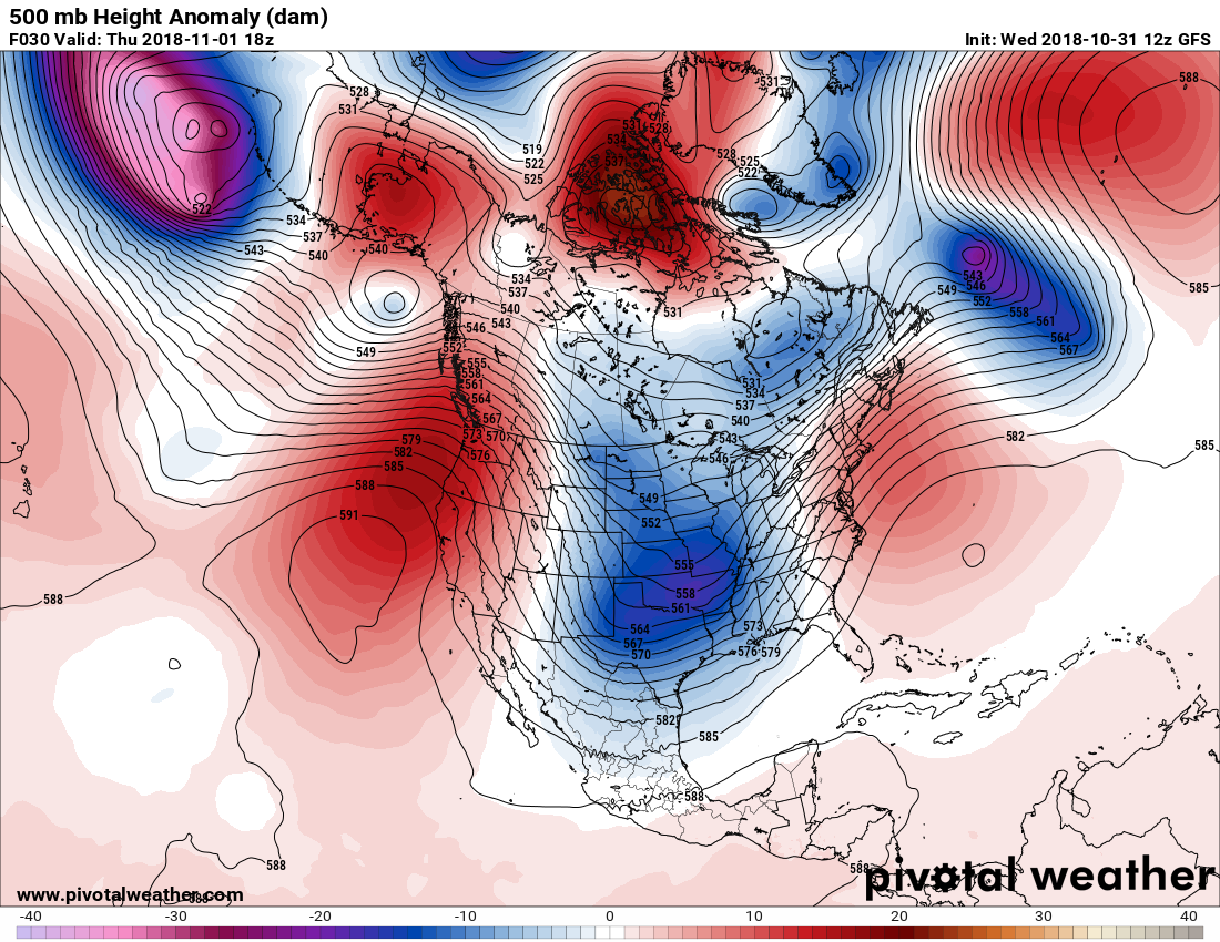
We do see the cold pocket signature of the storm that will be producing that severe weather in the nation’s mid section. What is a little “frightening” this Halloween is all the warm air aloft located above the Arctic Circle, which is leading to a very convoluted looking jet stream pattern on the above Pivotal Chart.
Because of the convoluted looking orientation of the jet I foresee a very stormy November for the U.S. with strong systems progressing eastward through the CONUS, some bringing the first significant snow to the northern tier of states. Is a stormy forecast that abnormal? Why, no depending on how significant and what area of the country storm systems affect. Sometimes even during an age of increasing warmth some months turn out “near average” temperature wise for countries geographically as large as the U.S., and indeed November 2018 might turn out to be not anomalously that warm or cold across my country.
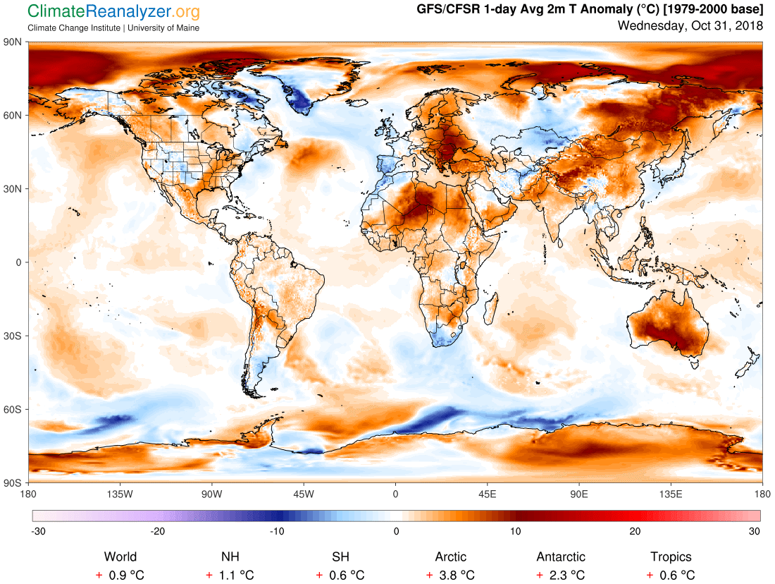
At the end of October we do see many warm anomalies around the globe looking at average two meter temps, though:
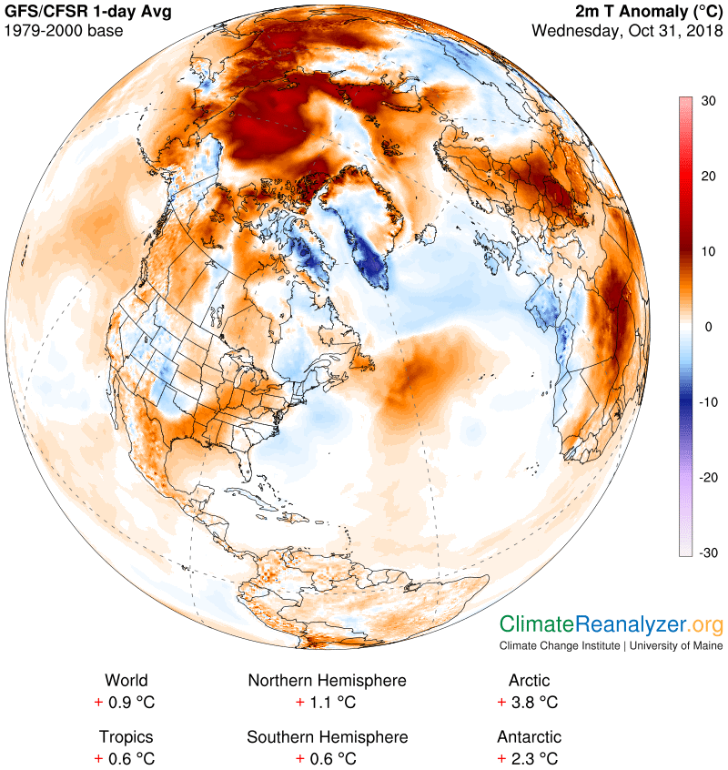
The most disturbing warmth continues to be near the North Pole where the sea ice refreezing process has been very slow this fall:
Zack Labe is taking note of ominous ice trends, which are probably influencing warm atmospheric patterns, or vice a versa, around the Arctic:
Record low sea ice extent continues on the Atlantic side of the #Arctic Ocean. This region has been well below average over the last several months. Daily data on the chart is from the @NSIDC. pic.twitter.com/nD1tGpHmPX
— Zack Labe (@ZLabe) October 26, 2018
Well above average temperatures are projected to continue over the #Arctic Ocean for at least the next week. This is particularly shown in areas with a lack of sea ice (currently open water).
[Graphics available from https://t.co/3ktgI4YE1j ] pic.twitter.com/vCE575mdRA
— Zack Labe (@ZLabe) October 31, 2018
Here is the weather service forecast for temperatures in November, which makes logical sense looking at the latest meteorological models:
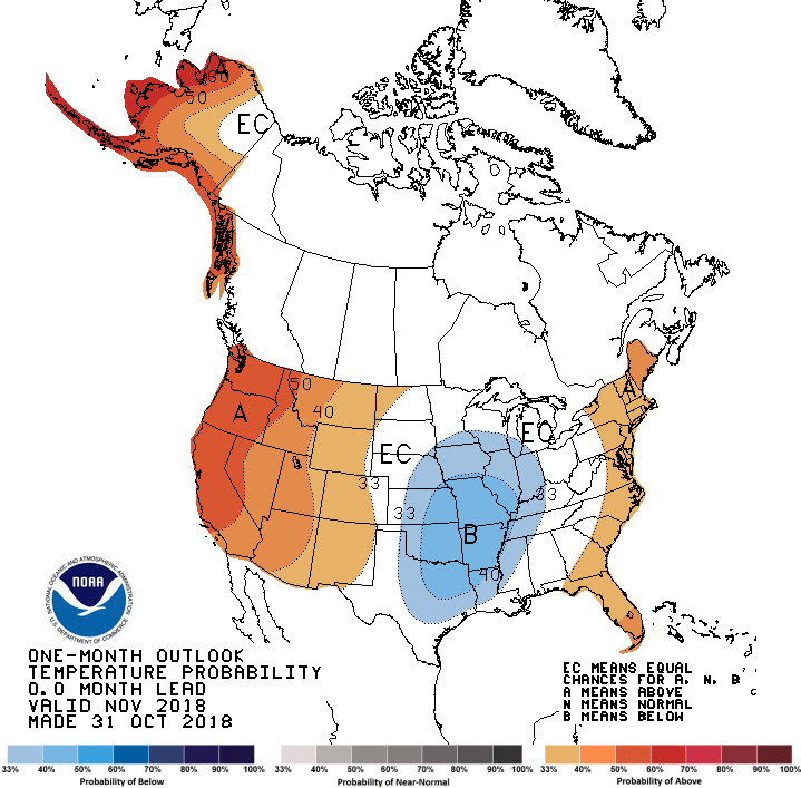
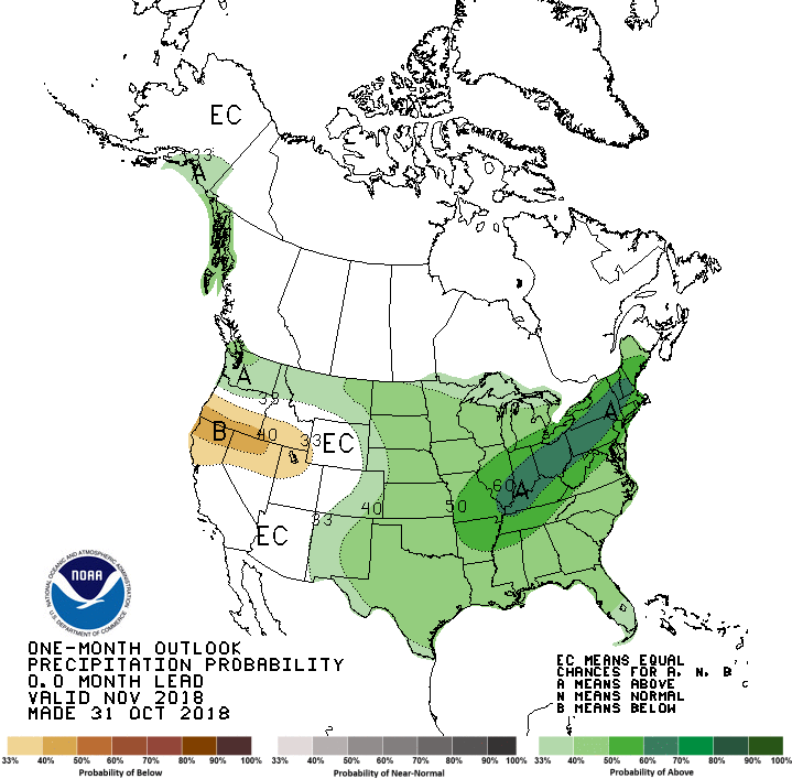
Cold shots will move south into the central CONUS inducing the mentioned storminess. It will probably be pretty wet east of the Rockies. We’ll need to keep a wary eye on California where the “dipole” may keep that state dry with a big threat for wildfires. If storm systems do have a tendency of digging into and developing in the nation’s heartland, high pressure building in their wake near the state of Utah would produce a few Santa Ana events. At least it appears that the CONUS won’t have to deal with any late season hurricanes as of this writing, although warmer than normal Gulf and Caribbean water temperatures have me slightly worried for “surprises.”
Since it’s extremely important, more so than at any other time in our nation’s history, to vote for candidates supporting climate change let’s see what the old Climate Guy can do with the not so simple task of forecasting weather trends for Tuesday 11/6. Here is what I am seeing from the GFS:
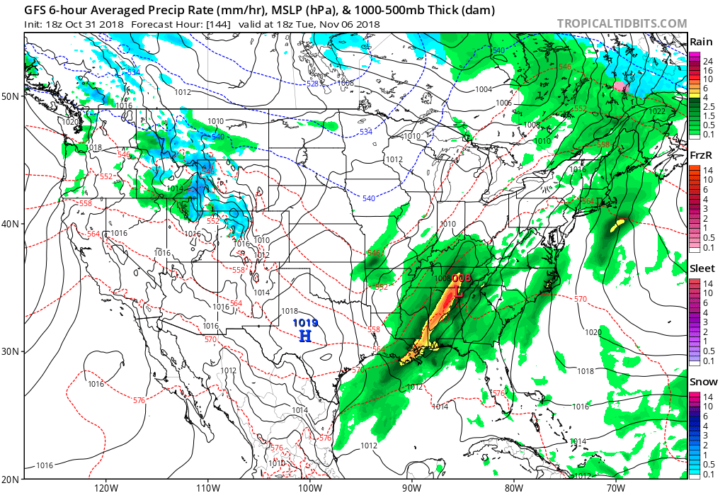
Another storm system may produce more severe weather in the Southeast. It’s a pretty good bet that umbrellas will be needed for those going to the polls in much of the East. Outside of some snow showers in the northern Rockies most of the West will be dry with mild temperatures.
That’s about all I see in my weather crystal ball for now. We’ll gaze again at the thing to see if the scary climate change induced weather from October holds over through November past Turkey Day daily on this site.
..………………………………………………………………………………………
Here is some climate and weather news from Wednesday:
(As usual, this will be a fluid post in which more information gets added during the day as it crosses my radar, crediting all who have put it on-line. Items will be archived on this site for posterity.)
"Global Warming Is Messing with the Jet Stream. That Means More Extreme Weather" via Bob Berwyn (@BBerwyn) of @InsideClimate News: https://t.co/TgpHDRYToQ
— Michael E. Mann (@MichaelEMann) October 31, 2018
See how trees in your city are improving air quality, reducing flood risks, and offsetting carbon emissions https://t.co/L2SUI1oYCc pic.twitter.com/tHBaMqQcew
— Climate Central (@ClimateCentral) October 31, 2018
(If you like these posts and my work please contribute via the PayPal widget, which has recently been added to this site. Thanks in advance for any support.)
The Climate Guy