Thursday November 8th… Dear Diary. The main purpose of this ongoing post will be to track United States extreme or record temperatures related to climate change. Any reports I see of ETs will be listed below the main topic of the day. I’ll refer to extreme or record temperatures as ETs (not extraterrestrials)😊.
Early November Trends/More October 2018 Climatology
We are now going into the second week of November so it is time to look at temperature trends for the new month. I typically post record count updates around the 10th of each month for all to peruse. Each month I have started the habit of presenting my “NCEI Record Count Scoreboard,” which I will show again on this post. I’m like a laundry machine on wash, rinse, repeat mode.😉
Let’s look at that scoreboard of counts of National Center for Environmental Information daily high maximum and low minimum records (updated through 11/04/2018): https://www.ncdc.noaa.gov/cdo-web/datatools/records

For this data set all monthly ratios of > 10 to 1 DHMX to DLMN or > 10 to 1 DLMN to DHMX are in bold type. The rankings are for the lower 48 states with the warmest ranking since 1895 of average temperatures being 124 and 1 being the coldest as of 2018. Blue colors represent cold months and red warm. Those months with counts close to a 1 to 1 ratio of highs to lows are colored black. Boldly colored months, such as May 2018, have ratios of more than 10 to 1 daily record highs to lows or lows to highs, and are either historically hot or cold. October 2018 had a near 1 to 1 ratio of record DHMX to DLMN individual counts, so the color I used for this month was black, although there were 112 more warm reports than cold. NCEI has processed October data across the country, determining that the lower 48 had its 44th coldest month since 1895, also added to the chart. The number 44 falls within the middle third of rankings (1-41, 42-83, 84-124), so is also colored black.
So far there have not been that many reports of records across the country for November, but we have seen 69 DHMX mostly associated with the West Coast ridge. The return of the dipole is causing cold air to pool in Canada and move southward into the U.S. such that we are seeing lots of blues on this chart:

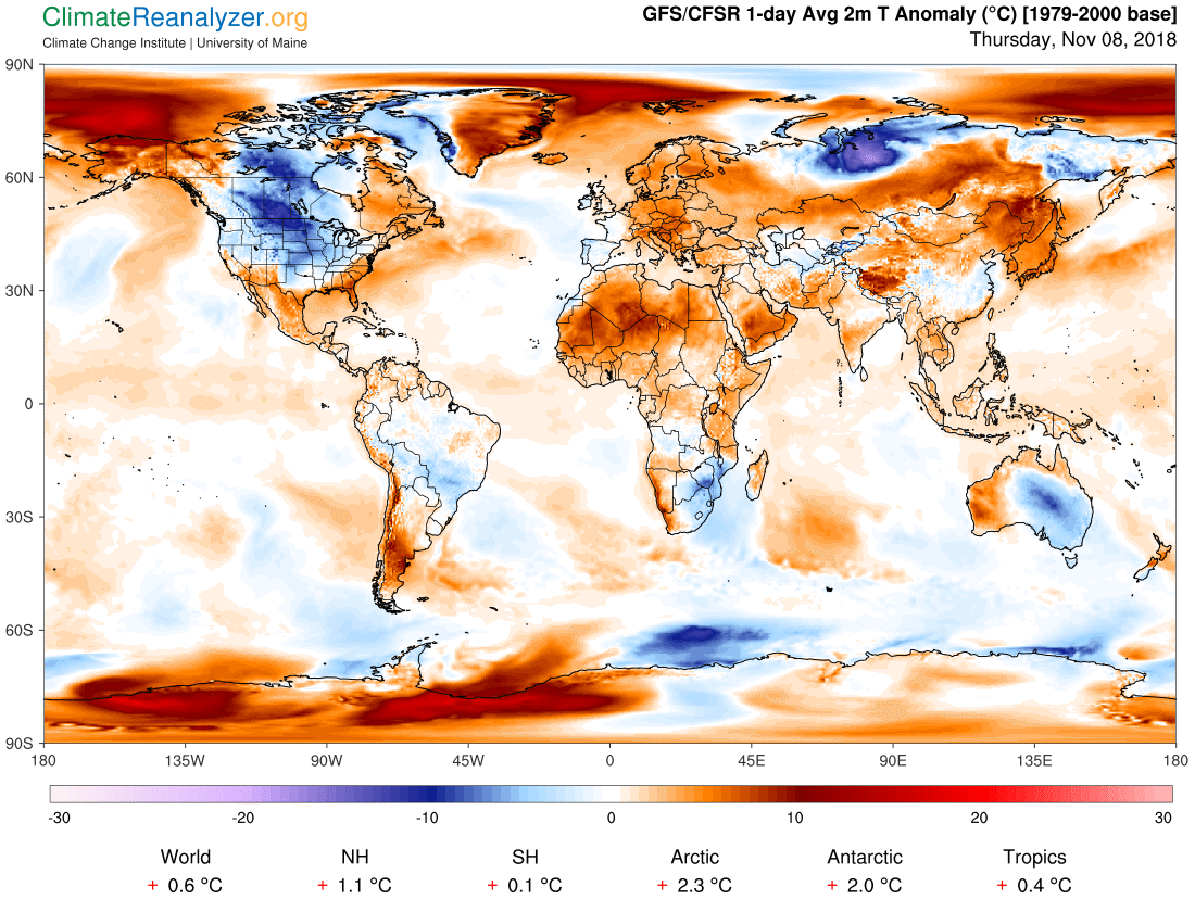
Most of the rest of the world is above average for temps, painted in orange hues as depicted by the Climate Analyzer chart, a clear sign of climate change. What we see in November stems over from what we saw average wise in October 2018:
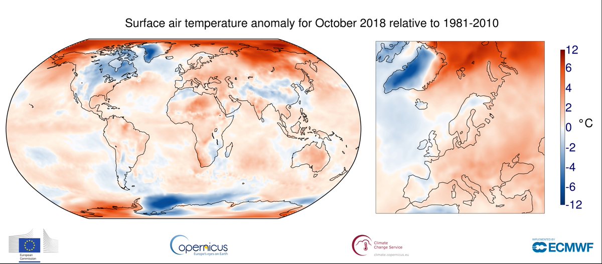
Selon @CopernicusECMWF, octobre 2018 est le 4e mois d'octobre le plus chaud sur le globe (derrière 2015, 2017 et 2016 !) et aussi le 4e plus chaud en Europe (derrière 2001, 2006 et 2000).
anomalie globale : +0.53°C
anomalie Europe : +1.06°C /moy 1981-2010https://t.co/rnFVsVhO2I pic.twitter.com/sbyY7Cx10e— Etienne Kapikian (@EKMeteo) November 6, 2018
The planet had it’s fourth warmest October in record according to Copernicus from Europe. We can see, though that most of North America was cooler than average looking again at the tweeted chart:

Major news broke later today. The dipole ridge/trough configuration over North America the last couple of months has caused tragic and deadly fire weather conditions for California yet again:
Heads up: More than 10M people in and near Los Angeles are in the highest possible risk area for fire weather ("extremely critical") on both Thurs and Fri. "Near record dry fuels for this time of year will continue to make rapid fire spread possible." https://t.co/0XjGJVGXxT https://t.co/bjYnf17TSn
— Bob Henson (@bhensonweather) November 8, 2018
Unfortunately, looks like yet another dangerous, extremely fast-moving California fire in wildland/urban interface amidst record-dry vegetation conditions. This time, it's #CampFire east of #Chico and already burning structures in #Paradise. Strong winds blowing. #CAwx #CAfire https://t.co/RaEWqjL2pP
— Daniel Swain (@Weather_West) November 8, 2018
It hasn't rained in Paradise, CA in over a month (Oct. 5). Their 0.14 inch of rain since Oct. 1 is only 3% of the average from Oct. 1 – Nov. 7. Winds + typical dried out vegetation at end of dry season + recent dry weather all factors in #CampFire. pic.twitter.com/TdKXDf2SRH
— Jonathan Erdman (@wxjerdman) November 8, 2018
Current conditions in #Chico:
Dew point: 7°
Sustained Wind: 23 MPH!
This is textbook fire weather. #CampFire pic.twitter.com/62hBHVf8D6— Chris Gloninger NBC10 Boston (@ChrisGNBCBoston) November 8, 2018
As if the fast-spreading #CampFire weren't bad enough, "extremely critical" fire risk (NOAA's most dire category) will spread into parts of Southern California from Thurs PM into Friday https://t.co/bpZYFxl8mZ pic.twitter.com/j5HPO1wLx1
— Weather Underground (@wunderground) November 8, 2018
Midnight at noon: Unbelievable stories and images coming out of #Paradise today as devastating #CampFire continues to burn right through populated areas. These photos were at *12 noon* (!) by Weather West reader evacuating toward Chico. (He has finally made it out). #CAfire #CAwx pic.twitter.com/qO4kVsJCKX
— Daniel Swain (@Weather_West) November 8, 2018
I knew there was a heightened risk today from the NWS report this morning, but oh my! This is heartbreaking. I just took this image from NASA Worldview and I can't stop trembling from the shock. pic.twitter.com/4LXI5TJK9S
— Scott Cook (@scook2214) November 8, 2018
Looks like the depth of the flaming head has increased as the fire burns through long residence time urban/suburban fuel loads in houses in #Paradise. #ParadiseLost #CampFire #CAwx #CAfire pic.twitter.com/8TVIo8w7po
— Neil Lareau (@nplareau) November 8, 2018
“Oh my God.. embers are going in the car… I can’t hardly breathe…” Coming up on @NBCNightlyNews, video of one family’s terrifying escape from Paradise, California as flames close in. #CampFire #ButteCounty pic.twitter.com/YrIz6ptJ3F
— Gadi Schwartz (@GadiNBC) November 8, 2018
BREAKING: Emergency officials say evacuations being ordered in parts of Butte Co., Calif., north of Sacramento, due to fast-spreading #CampFire – NBC pic.twitter.com/54tEue9dtC
— Breaking911 (@breaking9111) November 8, 2018
Likelihood of extreme summer weather patterns (as in 2018 w/ #CaliforniaFires–last night's new #CampFire below) to increase because of #climatechange @MichaelEMann https://t.co/87cRo2oUtw pic.twitter.com/HrlbVQzwd0
— Warren Karlenzig (@Greenflow) November 8, 2018
Great, now there's a wildfire threatening 3,500-4,000 structures in Ventura County, too — just 5 miles from where last night's shooting took place. https://t.co/QloYdeu2hP
— Eric Holthaus (@EricHolthaus) November 8, 2018
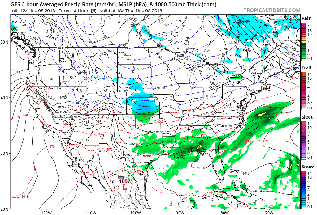
Looking at the surface pressure panel from this morning one can definitely see why we have a growing fire concern:

High pressure is building into the Great Basin area causing dry easterly winds to blow across California.
Hard to convey how extreme fire conditions are right now for the #CampFire. 30-50 mph gusts into record fuels. ERCs are >97th percentile for *all days of the year* in the 1979-2015 data set. #CAfire pic.twitter.com/ta8lFQuWkH
— Rob Elvington (@RobElvington) November 8, 2018
According to CAL FIRE, only nine wildfires in modern California history have destroyed 1000 or more structures. In less than 12 hours' time, #CampFire may have already passed that threshold https://t.co/9ySyeXkcHy
— Bob Henson (@bhensonweather) November 9, 2018
……………………………………………………………….
Here is more climate and weather news from Thursday:
(As usual, this will be a fluid post in which more information gets added during the day as it crosses my radar, crediting all who have put it on-line. Items will be archived on this site for posterity.)
#JustTransition– a comprehensive exploration of the UK's prospects for a just transition towards a #sustainable future and environmental justice: https://t.co/PJwGF35GBb
Part One – Kingdom of #Coal: https://t.co/hPF8Yjkuw8
Part Two – City of #Oil: https://t.co/PC3j6t7d74 pic.twitter.com/xVcmzPZTjk
— DeSmog UK (@DeSmogUK) November 8, 2018
ANOTHER Reason Why #ClimateChange IS A National Security Issue –
Here's how much warming has taken place at individual military sites around the USA https://t.co/tcv3GP3c5q via @ClimateCentral @1620Vet @Just_Resisting_ @EaterSouls @Nealinthekeys @CLIMATEMAMA @1o5CleanEnergy pic.twitter.com/teUNSUp0eE
— Allan Margolin (@AllanMargolin) November 8, 2018
@SouthPark deserves credit for devoting an entire episode to apologizing to @algore. The only question now is whether this will convince climate change skeptics who were initially convinced by them. @MichaelEMann https://t.co/2OrgVPzsRf
— Matthew Rozsa (@MatthewRozsa) November 8, 2018
Hurricane Michael wiped out much of the Mexico Beach, Florida community, including dozens of homes characterized as minimal flood risks by FEMA.https://t.co/5HvmKWQGWq
— InsideClimate News (@insideclimate) November 8, 2018
LOTS of talk how this election was a loss for climate change.
Well friends.
Tell that to:
New Mexico
Colorado
Nevada
Illinois
New York
MaineAll of which are now under complete Democratic control and about to embark on massive renewable energy plans.😘https://t.co/DJZi9AuoFt
— Eric Holthaus (@EricHolthaus) November 9, 2018
A good climate platform will talk about climate as the basis for all other issues: health care, jobs and the economy, immigration, and decency to our fellow humans. https://t.co/kq8H8OxKNo
— Eric Holthaus (@EricHolthaus) November 8, 2018
(If you like these posts and my work please contribute via the PayPal widget, which has recently been added to this site. Thanks in advance for any support.)
The Climate Guy