Thursday November 29th… Dear Diary. The main purpose of this ongoing post will be to track United States extreme or record temperatures related to climate change. Any reports I see of ETs will be listed below the main topic of the day. I’ll refer to extreme or record temperatures as ETs (not extraterrestrials)😊.
Jet Split Flow… A Sign of El Nino
Today I’m going to put my meteorological hat back on, letting all know of more weather signs that indeed El Nino may be developing. Met models are forecasting a typical El Nino pattern brewing across the CONUS with some climate change ramifications going into December. The bottom line here is that early December will be colder than average for most of the CONUS with strong systems alleviating drought in California, which will also produce some heavy precipitation that could lead to some flooding across portions of the South, and systems reinforcing biting chill across the northern tier of states with more lake effect snow. Across the central states we may see a wintry mix of ice and snow. The climate link here? Even though the jet pattern may be much more typical for December watch for heavier than usual precipitation.
Here is the typical El Nino weather pattern for winter:
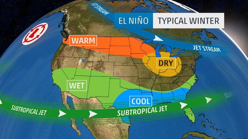
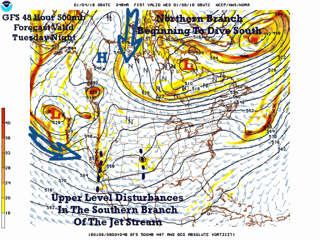
Meteorologically what we also look for is a “slit flow” between the northern and southern portion of the polar jet. The subtropical jet running to the south of the southern branch of the polar jet supplies both energy and juice for southern U.S. storms. The split southern portion of the jet typically ushers in storms into California through the South. The northern portion usually is located much further north than a “phased” jet; thus, allowing temperatures to be warmer than average across most of the northern tier of states. The northern branch in a typical El Nino winter sometimes dips into the Northeast producing average chilly conditions there and producing the “wedge” of cold air funneling southward through the Mid-Atlantic and South, creating episodes of icy messes:
So what similarities to a typical El Nino pattern do we have on the latest met models from Thursday? By 12/6/18 we see an eye opening forecast at 500 millibars:
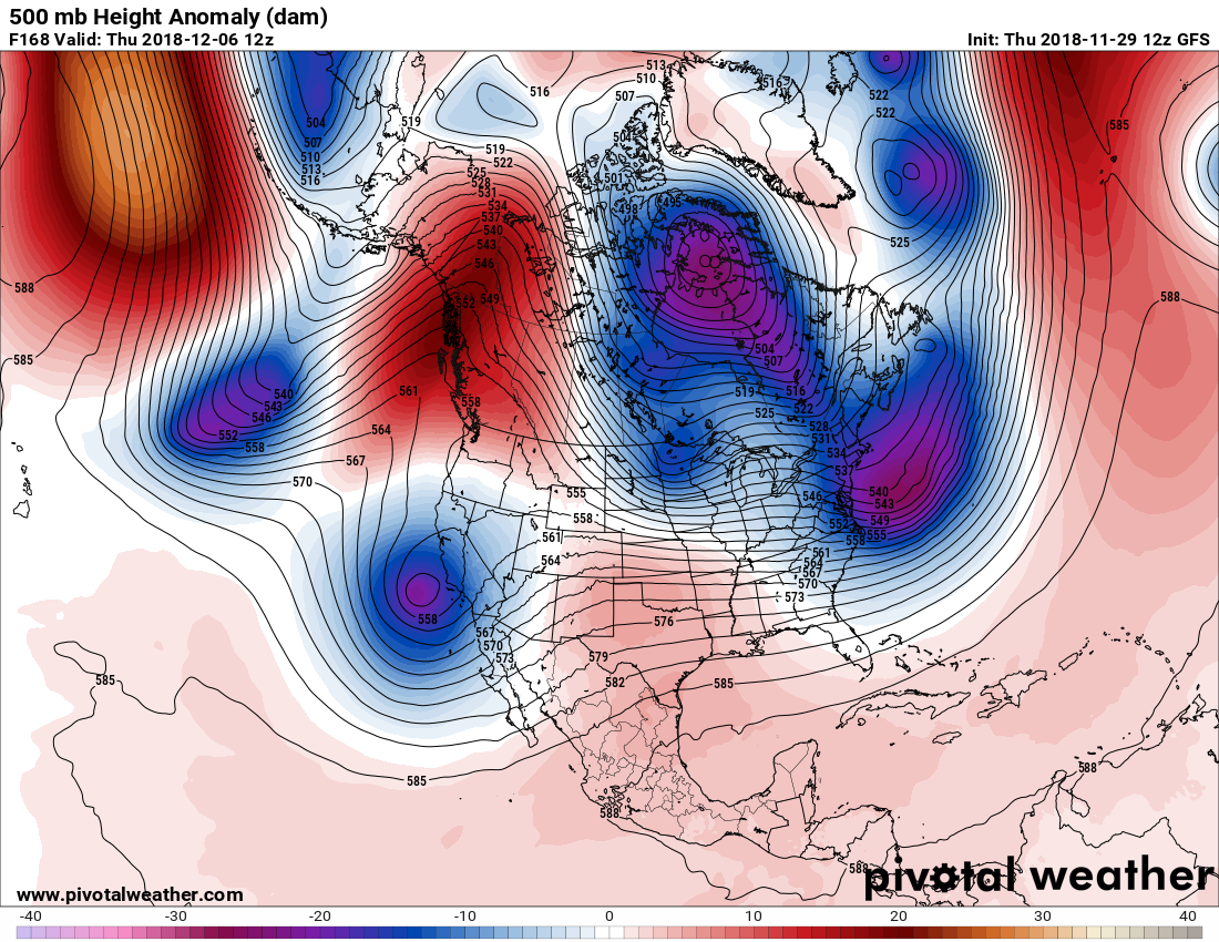
The jet is definitely split with two strong systems poised to move into California, one just off the coast and another well south of the Gulf of Alaska as denoted by the blue lobes on the Pivotal chart in the Pacific. The northern branch is pumping cold air into the Northeast. Here is what is forecast by the GFS at the surface:

Eventually the storm system over California may produce an icy cold, wet system for much of the South and Middle Atlantic:
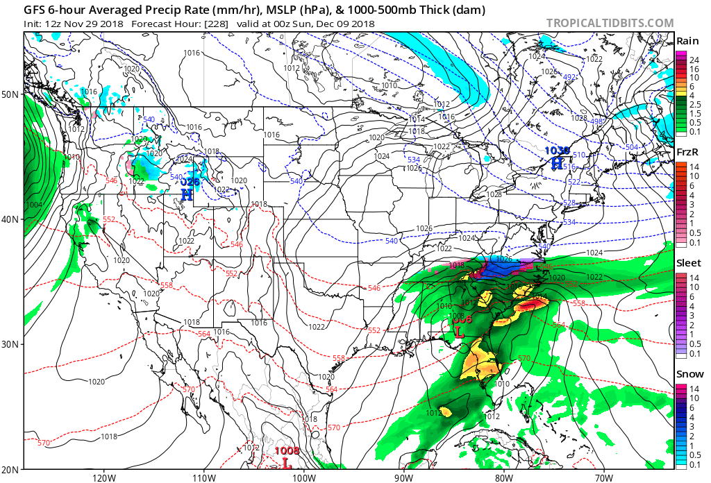
As a reminder on all of my posts when I present models going out more than 5 days the proverbial devil is in the details. Forecast busts are likely on presented individual panels and graphics, so I am just showing “trends.” In any case the trends that are very important going into December I’m seeing are a parade of wet systems pounding California, producing mudslides in burn scar zones, and some wicked storm systems traversing the South. I pray that we won’t see more fatalities in California. I do see some good news since the Sierra and southern Rockies snow pack will be replenished greatly this coming season. Just today:
#HolyFloodWatch Glen Ivy Rd. after 11:00 a.m. 11/28/2018 pic.twitter.com/LhxIg26rYF
— CAL FIRE Riverside (@CALFIRERRU) November 29, 2018
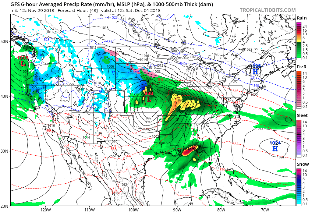
The next short term weather system that may produce havoc is more spring like, potentially producing some severe weather across the South with some snow in the norther Plains as November flips to December on the old calender:
Lastly, what do current sea surface temperatures look like in the Pacific?

At least a weak El Nino signature is definitely there off the west coast of South America. Throw in global warming and I bet there will be several surprises across the United States through the winter of 2018/19. We’ll bring these up one by one on the Extreme Temperature Diary as we go through time.
…………………………………………………………………………………………….
Here are more of Thursday’s climate and weather news items:
(As usual, this will be a fluid post in which more information gets added during the day as it crosses my radar, crediting all who have put it on-line. Items will be archived on this site for posterity.)
Under the legislation, all energy sold in the city would come from renewable sources within the next 15 years. That would be one of the fastest transitions to clean energy in the country. https://t.co/m8w6W4sIrO
— Jeff Berardelli (@WeatherProf) November 29, 2018
We are witnessing major hydrologic change
We see for the first time a very distinctive pattern of the wetland areas of the world getting wetter, in the high latitudes & the tropics, & the dry areas in between getting drier
Says James Famiglietti #NASAhttps://t.co/FPisvVYW3v #
— #ClimateJustice (@1o5CleanEnergy) November 29, 2018
Presentations that provide the big picture before details are easier to understand. https://t.co/7PRIMIhgHt
— Scott Cook (@scook2214) November 29, 2018
That is really bad! They don't air Katharine Hayhoe, a scientist who has spent the past years cowriting the National Climate Assessment, and instead put on someone who has no clue but just dismisses the assessment because it doesn't fit his ideology. https://t.co/PvrTvxCyS7
— Stefan Rahmstorf (@rahmstorf) November 29, 2018
The last four years have been the four warmest on record for the planet #climatechange #StateOfClimate pic.twitter.com/0XG1xhCwnU
— Ed Hawkins (@ed_hawkins) November 29, 2018
"Climate change is more extensive and worse than once thought" by Seth Borenstein (aka @BorenBears) for the @AP: https://t.co/2JFaqj0aX0
— Michael E. Mann (@MichaelEMann) November 29, 2018
"MIT research team demonstrated the device could cool equipment by 11 degrees F below ambient air temperature. New models should be able to reduce temperatures by more than triple that and could be useful in cooling food and medicine entirely off the grid" https://t.co/ULdTaSDUEg
— Jeff Berardelli (@WeatherProf) November 29, 2018
Why rising seas will force coastal residents to move: Guardian https://t.co/19KU1nBEDO | More w/ Eco-Search: https://t.co/mA5N5075iq
— EcoInternet (@EcoInternet3) November 29, 2018
Great news! Mother nature is increasing that snowpack:
24 hour snowfall reports as of 7:30am across the region. Expect continued snowfall through today with additional accumulations. #CAWx #NVWx pic.twitter.com/DTHj3cyTg2
— NWS Reno (@NWSReno) November 29, 2018
From snow on one area of the planet to fire on another:
Wildfires continue to rage in southeastern #Queensland #Australia, driven by strong westerly winds – #Himawari pic.twitter.com/uGWQUJ0fOL
— Dan Lindsey (@DanLindsey77) November 29, 2018
#ClimateChange: CO2 emissions on the rise
Name & Shame!
"The study says that countries including #Australia, #Canada, #UK, #SouthKorea, #SaudiArabia, #SouthAfrica & the #USA, are falling short"
https://t.co/Bu3j8odTqG#EnergyTransition#SustainableEnergy#Renewables#COP24— Prof Peter Strachan (@ProfStrachan) November 29, 2018
Extreme Temperature Diary- November 29, 2018- Jet Split Flow…A Sign of El Nino -(https://t.co/DqTUVZvnxD) click on: (https://t.co/C99xZwZfB6)
#ClimateChange #Science #ClimateChangeIsReal #ClimateAction. pic.twitter.com/Bg1MjoP9N8— Guy Walton (@climateguyw) November 29, 2018
(If you like these posts and my work please contribute via the PayPal widget, which has recently been added to this site. Thanks in advance for any support.)
The Climate Guy