Thursday June 20th… Dear Diary. The main purpose of this ongoing blog will be to track United States extreme or record temperatures related to climate change. Any reports I see of ETs will be listed below the main topic of the day. I’ll refer to extreme or record temperatures as ETs (not extraterrestrials).😉
Dangerous Heat Wave Slated For Europe Centered On France and Germany
While most of the United States, so far, has not experienced an extremely hot episode, Europe appears to be poised to undergo some dangerous heat. Remember that during the summer of 2018 portions of Europe got exceptionally hot. My buddy Bob Henson of Weather Underground let me know of this meteorological article addressing the coming heat wave for Europe, which may be centered on Germany and France:
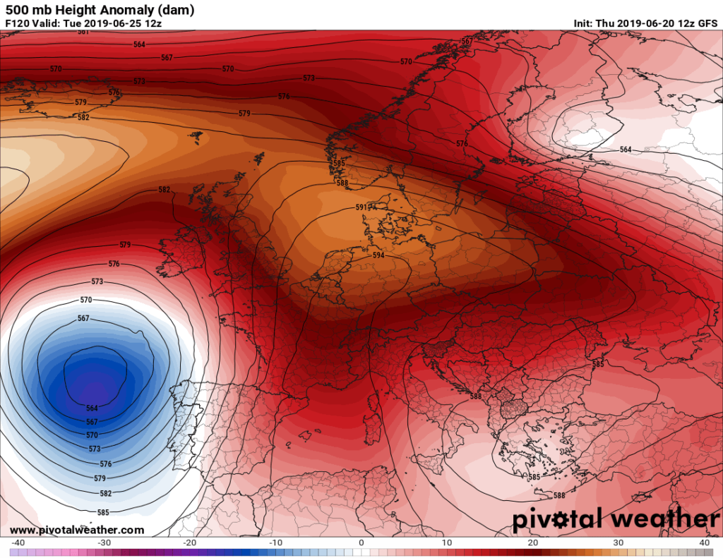
I did some checking this morning and indeed it appears that a strong heat dome will be building over central Europe on Tuesday June 25th, five days from now:
Here is a repost of most of the Met article:
A significant heat wave with peak temperatures above 35 °C is becoming increasingly likely next week, June 24-30th 2019
By SWE | Mesoscale Discussion | 19 June 2019
Models are is a good agreement for the development of an intense heat wave across a large part of west-central Europe, starting on Monday next week and likely extending until the weekend. Both global models GFS and ECMWF are hinting at peak afternoon temperatures in excess of 35-38 °C in some areas next week! Let us take a look at some details.
The pattern evolution seems to be trending towards an extensive omega blocking ridge developing over Europe through mid next week, with two upper lows on the edge – one over the N Atlantic and another one over SE Europe.
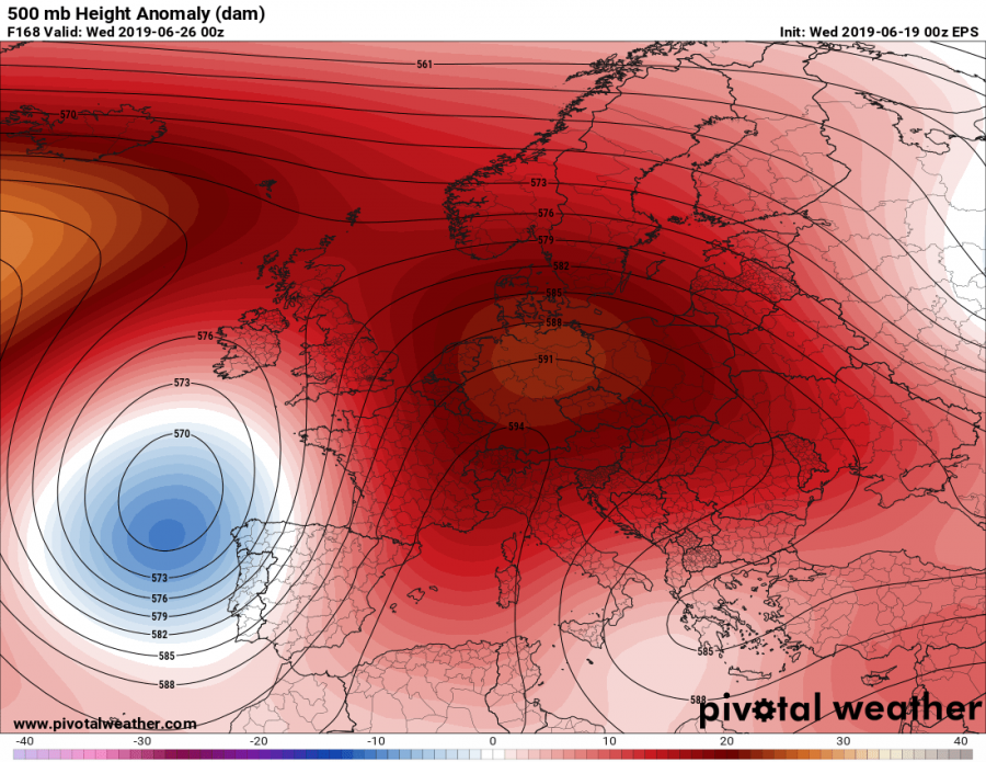
The heat wave starts after Sunday when a powerful upper ridge develops over our continent. As soon as the omega pattern establishes, strong warm advection should take place with a ‘Spanish plume’ from SW Europe. Models are trending with very extreme temperature anomaly for the near-surface layers, locally reaching 12-16 °C above normal for late June!
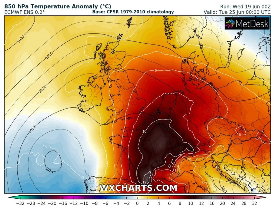


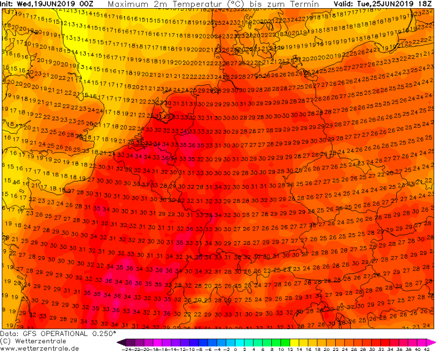
GFS model is hinting the peak afternoon temperatures will climb well above 35 °C in some areas. Starting with near this threshold on Tuesday across E France and Benelux, then intensifying on Wednesday also over NW Germany and central France. On Thursday, the heat wave would eventually peak over Germany with local temperatures ever approaching 40 °C in NW and NE Germany while on Friday, a cold front might push from the west and finish the heat wave, but the excessive heat would then push towards the Alpine region and Poland / Czechia as well.


It looks like Europe is heading for a very significant heat wave through the remainder of June. Extreme heat could develop over some areas, locally reaching 35-40 °C in the afternoons next week. Such anomalous temperatures would likely break June records in some areas – stay tuned for additional details in the coming days!
Of course I will be reporting on the European heat.
Dear Diary. Here is an afternoon update from Bob Henson:
In the United States a low grade heat wave is building across Oklahoma, Texas and Louisiana where widespread heat advisories have been put in place by the National Weather Service:

This new area of heat will continue to build across the South into Friday:

I suspect that most of the southern states are in for a prolonged period of maxes above 90F but below record levels. Next week the heat will be building through the muggy Plains. Of course, these heat waves are made much more likely and could eventually become severe this summer due to our collective carbon pollution.
Here is more climate and weather news from Thursday:
(As usual, this will be a fluid post in which more information gets added during the day as it crosses my radar, crediting all who have put it on-line. Items will be archived on this site for posterity. In most instances click on the pictures of each tweet to see each article.)
(If you like these posts and my work please contribute via the PayPal widget, which has recently been added to this site. Thanks in advance for any support.)
Guy Walton- “The Climate Guy”