Friday June 21st… Dear Diary. The main purpose of this ongoing blog will be to track United States extreme or record temperatures related to climate change. Any reports I see of ETs will be listed below the main topic of the day. I’ll refer to extreme or record temperatures as ETs (not extraterrestrials).😉
Hot Spots Starting Summer In The United States
When I tweet out the existence of this post I will be showing my #MetsUnite stripes. For more on that commemorating the official start of summer at the solstice see:
For today’s main subject let’s look at where dangerous heat has already made an appearance in the United States and the prospects for that heat expanding into other areas of the country.
As one might expect using traditional climatology some dangerous heat has made an appearance in the southern U.S. as has been pegged by National Weather Service advisories from Kansas southward through Texas and eastward through portions of the Gulf coastal states:
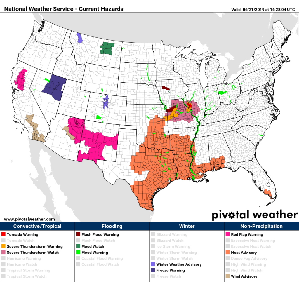
Red flag conditions have been posted for portions of the West, indicating that conditions are dry and hot enough for all to be very alert for wildfires.
P.S. A derecho is moving southeast just North of today’s heat zone, which is interacting with instability and energy in the central Plains:
Looking at forecast maxes on Saturday the temperature regime will not change much for either the West or South except that 90s will be replaced by 80s as far south as the Rio Grande, separating Oklahoma from Texas:

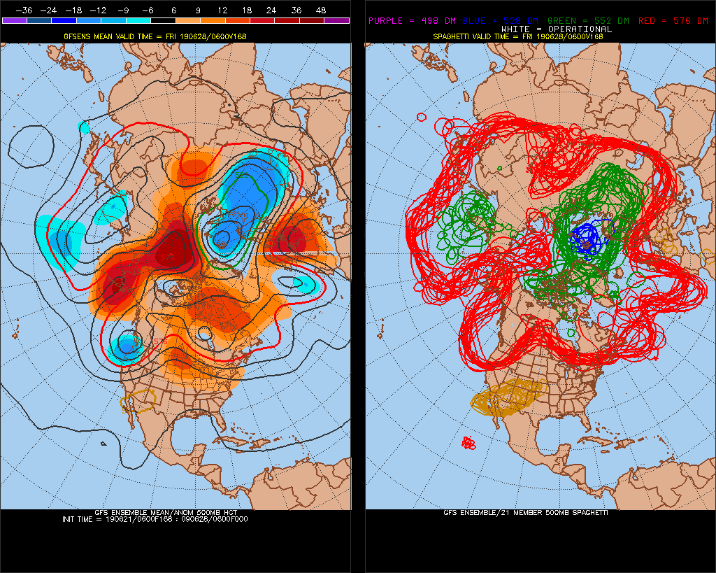
So what are the prospects for heat building northward into the early summer? Of course, for that question to be answered we need to look at models and ensembles. This morning’s GFS strongly hints that there won’t be a heat dome building over the nation’s mid section for the last week of June. Instead a weak disturbance may shift from the Gulf into the nation’s mid section keeping the Plains and points east moist and unstable, not allowing dangerous heat to develop north of where it already is. Here is what the GFS has by next Friday:

Ensembles show that any heat done will be building on or near Arizona or New Mexico, which climatologically would indicate that a big upper level ridge won’t be developing east of the Rockies anytime soon:
The European model also shows this weak troughing in between the Southwestern ridge and Bermuda High ridge off the East Coast. This is actually a common pattern during the early summer:
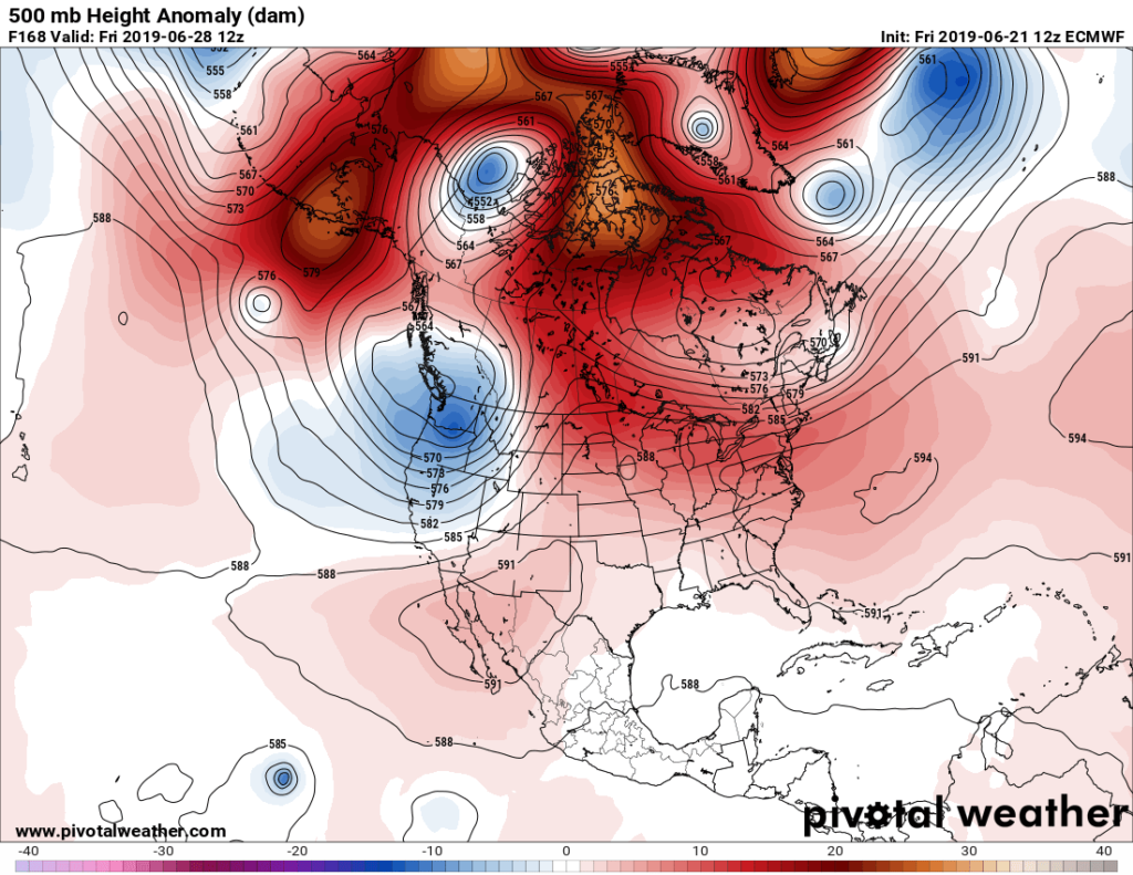
On the other hand ensembles do forecast higher than average 500 millibar heights across a great deal of the country, so I’m a little wary of traditional climatology. Until we see this “weakness” develop across the nation’s mid-section all bets are off. We will bave an update about what transpires with U.S. heat next week.
Here is more climate and weather news from Friday:
(As usual, this will be a fluid post in which more information gets added during the day as it crosses my radar, crediting all who have put it on-line. Items will be archived on this site for posterity. In most instances click on the pictures of each tweet to see each article.)
Here is a big ET report from Friday:
(If you like these posts and my work please contribute via the PayPal widget, which has recently been added to this site. Thanks in advance for any support.)
Guy Walton- “The Climate Guy”