Monday July 15th … Dear Diary. The main purpose of this ongoing blog will be to track United States extreme or record temperatures related to climate change. Any reports I see of ETs will be listed below the main topic of the day. I’ll refer to extreme or record temperatures as ETs (not extraterrestrials).😉
Major Heat Wave Coming For U.S. And July Record Scoreboard Update
So what big event comes next for the U.S., weather wise, after Barry? Why, the most significant heat wave of the year. Before I get to that we need to do some monthly bookkeeping, which was delayed by reporting on Barry tangling with the lower Mississippi Valley.
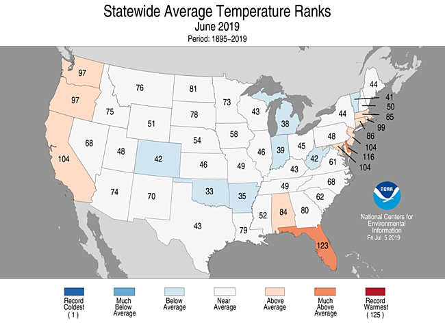
June 2019 got ranked by the National Center for Environmental Information as a near average month for the lower 48 states since 1895. June 2019 was not a month of extremes across sections of the Continental United States, so relatively few records were reported, but Alaska continued to see record warmth, particularly towards the end of the month. Also, Florida baked where Miami at times got above 95F, which is unusual. Here are averages by state for June:
Here is that record scoreboard updated through 7/13/2019:
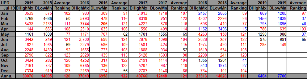
For this data set all monthly ratios of > 10 to 1 DHMX to DLMN or > 10 to 1 DLMN to DHMX are in bold type. The rankings are for the lower 48 states with the warmest ranking since 1895 of average temperatures being 124 and 1 being the coldest as of 2019. Blue colors represent cold months and red warm. Those months with counts close to a 1 to 1 ratio of highs to lows are colored black. Boldly colored months, such as May 2018, have ratios of more than 10 to 1 daily record highs to lows or lows to highs, and are either historically hot or cold.
May 2019 had a near 1 to 1 ratio of record DHMX to DLMN individual counts, so the color I used for this month was black.
The ranking for the month was 65, which is very close to the average ranking of 62, which is also colored black, and matches well with DHMX and DLMX counts. I color rankings + or -10 from the average ranking of 62 black indicating that these are near average temperature wise.
July 2019 has gotten off to a warm start, particularly in Alaska where I see that the NCEI site has recorded, so far, 10 all-time record highs; however, there have not been that many reports of daily records relative to history. So, we are starting with a near blank slate when it comes to the next heat wave, which probably be the worst for a good portion of the east and central states since 2016.
The year 2019 simply has not been that hot, as a whole, across the continental U.S. Could that change over the next few months?
I have noted back in 2013 and 2014, two of the cooler years this decade for the U.S., that by July of those years there was not much change during subsequent months.
I’m not that impressed with the heat dome for this coming event this week going into the last week of July at 500 millibars. The “whoppers” are associated with heights well over 594 decameters. Here is what the latest European model has by Friday:
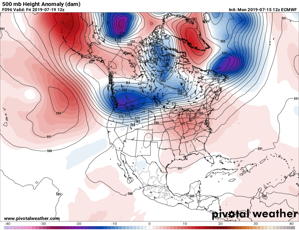
The key to the longevity of this heat wave will be what happens to most of that cold, blue blob centered over British Columbia with another short trailing westward through the Gulf of Alaska. Will the thing dig into the West building the ridge over the East, or will the bulk of the blue blob dig into the Great Lakes, squashing the heat wave east of the Mississippi after this weekend?
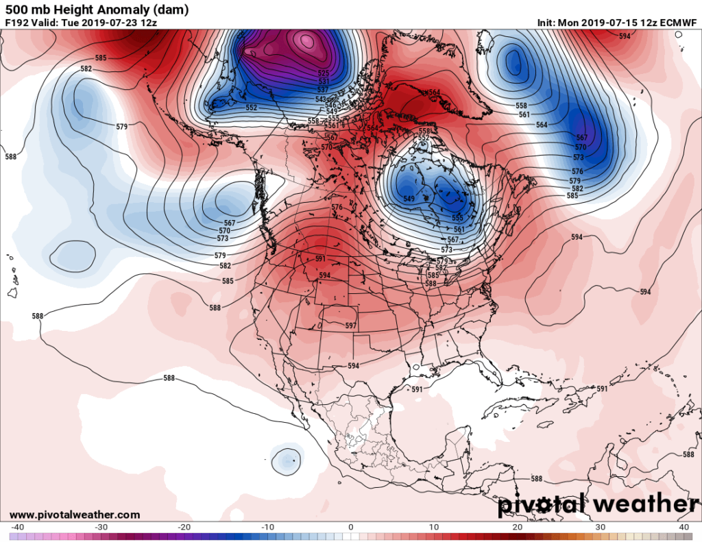
The European model, our most reliable piece of guidance, compromises, building the ridge in the West to about 597 decameters, but does not dig the trough very far into the Southeast:
In the short term dangerous heat will be building over the Plains by Tuesday west of the remnants of where Barry will reside over the mid-Mississippi Valley:

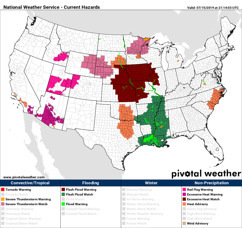
We already have a heat watch over portions of the Midwest with several small areas of heat advisories and warnings scattered across the continent:
Others have noted that Barry’s tropical moisture will combine with rising temperatures to produce widespread dangerous heat indices be Thursday and Friday east of the Rockies:
Of course, I’ll be reporting on this heat wave through its duration.
While the United States had an “average” month in June the rest of the world had a record warm month.
Now this is big and alarming news!
Here is more climate and weather news from Monday:
(As usual, this will be a fluid post in which more information gets added during the day as it crosses my radar, crediting all who have put it on-line. Items will be archived on this site for posterity. In most instances click on the pictures of each tweet to see each article.)
(If you like these posts and my work please contribute via the PayPal widget, which has recently been added to this site. Thanks in advance for any support.)
Guy Walton- “The Climate Guy”