Friday March 6th… Dear Diary. The main purpose of this ongoing blog will be to track United States extreme or record temperatures related to climate change. Any reports I see of ETs will be listed below the main topic of the day. I’ll refer to extreme or record temperatures as ETs (not extraterrestrials).😉
Main Topic: Early March Record Scoreboard and Climatological Review
Dear Diary. The signs of global warming are everywhere as of early 2020.
The United States just came off its 6th warmest winter. The winter of 2015/16 was warmest. Europe just had its warmest winter on record, and Australia had it’s hottest summer on record.
This Inside Climate News article, which you may want to read, encapsulates what many felt from December through February:
https://insideclimatenews.org/news/04032020/winter-southeast-united-states-polar-vortex-warming
In Dozens of Cities East of the Mississippi, Winter Never Really Happened
Something called the Arctic oscillation helped keep the polar vortex at bay. And then there’s climate change.
By James Bruggers
Mar 5, 2020

Maggie Olson, left, and Krista Newton enjoy a walk on the Big Four Bridge in Louisville, Kentucky, while they make the most of the sunny skies and temperatures above 60 degrees Tuesday, March 3, 2020. Credit: Alton Strupp/Courier Journal
It’s that time of the month when NCEI has completed their assessment for the prior month, so I’m trotting out record scoreboard updates.
Here on this site we present monthly summaries near the 6th of each month, and each is available if you want to go back through my Extreme Temperature Diary archive.
I’m repeating my mantra from last month:
February 2020 got ranked by the National Center for Environmental Information as a well above average February, temperature wise, for the lower 48 states, coming in as 30th warmest or 97th coolest since records began being kept in 1895:
https://www.ncdc.noaa.gov/cag/national/rankings/110/tavg/202001
Here we see rankings for each state in the contiguous United States:

Just like from January we see a disturbing pattern of above average temperatures from coast to coast. The core of the most anomalous warmth was in the Northeast and California.
Here are my two U.S. Daily Record Scoreboards updated through 3/6/2020 (data compiled from the following NCEI site):
https://www.ncdc.noaa.gov/cdo-web/datatools/records


DHMX= Daily High Max Reports. DLMN= Daily Low Min Reports. DHMN= Daily High Min Reports. DLMX=Daily Low Max Reports.
For these data sets all monthly ratios of > 10 to 1 DHMX to DLMN or > 10 to 1 DLMN to DHMX are in bold type. The rankings are for the lower 48 states with the warmest ranking since 1895 of average temperatures being 125 and 1 being the coldest as of 2020. Blue colors represent cold months and red warm. Those months and years with counts close to a 1 to 1 ratio of highs to lows are colored black. Boldly colored months, such as January 2020, have ratios of more than 10 to 1 daily record highs to lows or lows to highs, and are either historically hot or cold, most of which have made news.
February 2020 had approximately a 2-1 ratio of record DHMX to DLMN individual record counts, so the color I used for this month was red on the top chart.
February 2020 had approximately a 2-1 ratio of record DHMN to DLMX individual record counts, so the color I used for this month was red on the bottom chart.
Due to climate change we will see less blue colors on these Record Scoreboards with time, and in the United States February 2020 was no exception.
Also, looking at the record scoreboards, I wonder how long a cooling trend will last going into the 2020s, which we have seen since 2017? Certainly there has been a big turnaround in early 2020.
As stated, the ranking for February 2020 was 97, which was colored red. I color rankings +10 or -10 from the average ranking of 63 black, indicating that these are near average temperature wise.
Here is much more detailed U.S. climatology as complied by NOAA:
https://www.ncei.noaa.gov/news/national-climate-202002
Assessing the U.S. Climate in February 2020
Alaska’s coldest February and winter in 21 years; Sixth warmest winter on record for contiguous U.S.
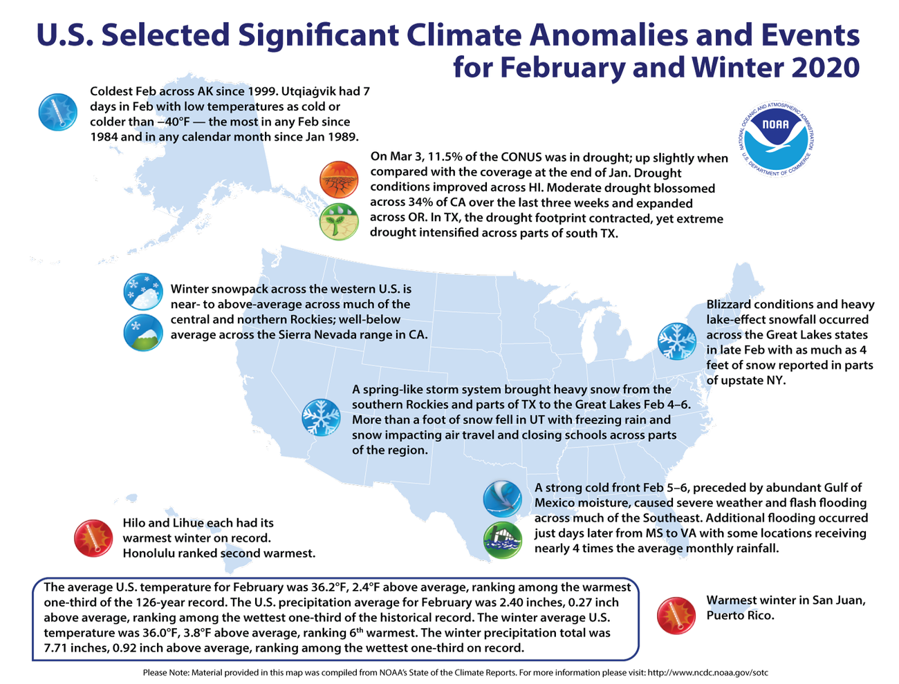
During February, the average contiguous U.S. temperature was 36.2°F, 2.4°F above the 20th century average. This ranked among the warmest one-third of the 126-year period of record. Despite being on record pace for warmest winter on record in January, the winter (December–February) average contiguous U.S. temperature was 36.0°F, 3.8°F above average, ranking sixth warmest winter on record.
The February precipitation total for the contiguous U.S. was 2.40 inches, 0.27 inch above average and ranked among the wettest one-third of the historical period of record. The winter precipitation total was 7.71 inches, 0.92 inch above average, and ranked among the wettest one-third of the 125-year period of record. For the 12-month period March 2019–February 2020, the precipitation total was 34.12 inches, 4.16 inches above average and the sixth wettest March–February period on record.
This monthly summary from NOAA National Centers for Environmental Information is part of the suite of climate services NOAA provides to government, business, academia and the public to support informed decision-making.
Temperature
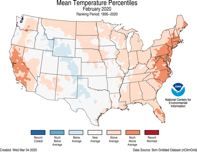
- Much-above-average temperatures were observed across parts of the Mid-Atlantic and Northeast as well as portions of California and Florida. New Jersey and Rhode Island ranked third warmest, while Maryland, Delaware and Connecticut ranked fifth warmest.
- Below-average temperatures were observed across portions of the central Rockies to western Texas during February. No state ranked below average for the month.
- The Alaska February temperature was 1.5°F, 3.3°F below the long-term average. This ranked among the coldest one-third of the 96-year period of record for the state and was the coldest February since 1999.
- The North Slope had its coldest February in 31 years.
- It was the coldest February since 1984 in Utqiaġvik (Barrow).
- Utqiaġvik had seven days in February with low temperatures as cold or colder than −40°F — the most in any February since 1984 and in any calendar month since January 1989.
- Cold temperatures across the region were a catalyst for rapid ice growth across the Bering Sea in February, where sea ice extent expanded to 100% of average for the month. This was the first February since 2013 where the Bering Sea ice extent was not below average.
Precipitation
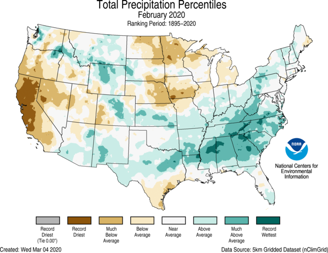
- Much-above-average to record wet conditions were present across much of the Southeast during February, as flooding rainfall on multiple days caused landslides and severe damage to roads and other infrastructure. In Jackson, Mississippi, the Pearl River crested at its highest level since 1983, inundating many homes. Several other rivers across Alabama and Mississippi were near-to or above flood stage. Georgia ranked second wettest, while Alabama and North Carolina ranked third wettest for the month.
- After a dry January across southwestern California, February brought little to no relief, with many locations reporting less than 5% of average rainfall. California ranked driest on record for February with 0.20 inch of precipitation, besting the previous record of 0.31 inch set back in 1964.
- Stations across the San Francisco Bay area and interior parts of northern California tied or set records for driest February on record. San Francisco, San Jose, Sacramento, Oakland and many other stations received no precipitation during the month, setting local records for the driest February.
- Air temperatures during the winter were warm enough across the Great Lakes to keep surface water temperatures above freezing across a large portion of the basin. As a result, enhanced lake-effect snow events occur much later in the season than on average, which lead to higher seasonal snowfall totals. This was indeed the case during February 27–29, as heavy lake effect snowfall impacted portions of the Tug Hill Plateau region of upstate New York. Cold and blustery winds blew across the length of Lake Ontario, over the relatively warm waters, lifting moisture and dumping several feet of snow along the downwind communities. Carthage, New York, received 48 inches of snowfall from this event while Croghan and Redfield observed 42.5 inches and 31.2 inches, respectively. Other communities south of Buffalo received between one and two feet of snow from this event and lesser amounts across the Upper Peninsula of Michigan According to the March 3 U.S. Drought Monitor report, 11.5% of the contiguous U.S. was in drought, up slightly from 11% at the end of January. With the extremely dry conditions during January and February across California, moderate drought blossomed across 34% of the state over the last three weeks and expanded across Oregon and into Nevada. In Texas, the drought footprint contracted, yet intensified as extreme drought expanded across parts of south Texas. Drought conditions improved across Hawaii. as well as the northern Lower Peninsula of Michigan.
Winter Temperature
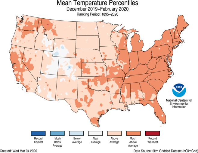
- The Arctic Oscillation (AO) was strongly positive for most of the winter, particularly in January and February. Twice in February, it set all-time records for its highest values.
- The positive phase of the AO is associated with enhanced troughing of the upper-air jet stream in the Arctic and enhanced ridging of the jet stream in the midlatitudes. This strengthens the jet stream and traps the colder temperatures in the Arctic, leaving warmer conditions to the south, including across the contiguous U.S.
- During January, February and the latter half of December, the jet stream was stronger than normal and upper-air troughs were strongest near Alaska, Greenland and central Russia, leading to persistently cold anomalies in those regions. The ridges were strongest over Europe, East Asia and the northeastern Pacific, allowing warmer anomalies to persist.
- As a result of this positive AO, winter temperatures were above average across most of the contiguous U.S. and much-above-average across the eastern U.S. West Virginia and Rhode Island each had their fourth warmest December–February on record. Twenty-two additional states had a top 10 warmest winter.
- The Alaska December–February temperature was 0.7°F, 2.9°F below the long-term average, ranking among the coldest one-third of the 95-year record and the coldest winter in 21 years. Much-below-average temperatures were concentrated in parts of the Central Interior region with below-average temperatures across much of mainland Alaska. Above-average temperatures were present across portions of the Panhandle.
- For the first time in 21 years, Fairbanks remained below freezing during all of climatological winter (December–February).
Precipitation
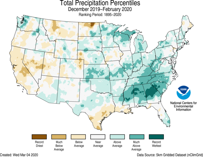
- Much-above-average to record precipitation was observed from the Southeast into the Great Lakes. Alabama and Georgia ranked wettest on record for winter precipitation, while South Carolina ranked second wettest. Parts of the West and northern Rockies received below-average precipitation for the season.
- Much of the Rockies, northern Plains, western Great Lakes and northern New England received average to above-average snowfall during winter. The Sierra Nevada Mountains, the southern Great Lakes and from the Ohio Valley to the Mid-Atlantic region and into the Northeast saw below-average to near-record low snowfall totals for the season. This was due in part to the northward deviation of the polar jet stream, which brought colder air to the West and warmer air across much of the eastern U.S. As a result, very few cold winter storms traversed the south-central portions of the Lower 48 and up the East Coast during the winter season.
- Climatologically speaking, winter is the wet season in California and across much of the West. If March and April do not produce adequate precipitation to make up for the dry conditions experienced during winter, there will be increased concerns regarding sufficient water resources to get through the dry season (summer) and also for the increased potential for wildfires this coming fall.
- While much of interior and northern Alaska was drier than average during the winter, portions of the Alaskan Panhandle were wetter than average. Petersburg, Alaska, received 40 inches of precipitation — the wettest winter since 2006–2007.
Please consider donating through the Paypal widget on this site. I need everyone’s support to continue my work, especially that of processing NCEI record count data for scientific research.
Here is some more weather and climate news from Friday:
(As usual, this will be a fluid post in which more information gets added during the day as it crosses my radar, crediting all who have put it on-line. Items will be archived on this site for posterity.)
(If you like these posts and my work please contribute via the PayPal widget, which has recently been added to this site. Thanks in advance for any support.)
Guy Walton- “The Climate Guy”