Tuesday December 1st… Dear Diary. The main purpose of this ongoing blog will be to track United States extreme or record temperatures related to climate change. Any reports I see of ETs will be listed below the main topic of the day. I’ll refer to extreme or record temperatures as ETs (not extraterrestrials).😉
Main Topic: U.S. Average Temperature Winter Forecast
Dear Diary. Welcome to boreal or meteorological winter if you live in the United States, or the three months that are December, January and February. It’s time for me to make another attempt at a forecast for average seasonal temperatures in the U.S. This forecast will be very broad and not specific for any one state comprising the continental United States.
So how will boreal Winter 2020/21 stack up compared to long term temperature averages across the United States? Will we continue to see the climate crisis signature of warmer than average conditions? Let’s try to make a forecast as usual at the start of a new season.
So how did the forecast work out for Fall 2020? Here is a link to the post for that forecast:
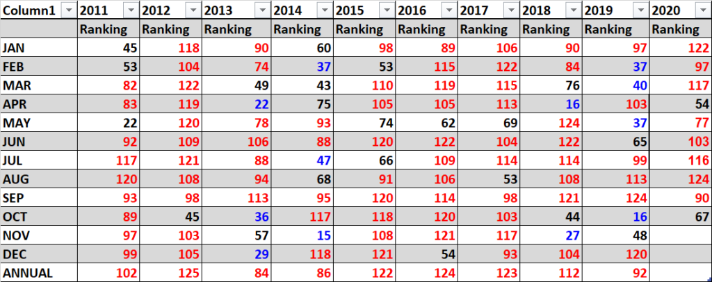
By December 7th the National Center for Environmental Information will finish their assessment for Fall 2020, so our verification is not complete as of December 1st. Let’s do fill in ranking numbers with 1 being the coldest and 126 warmest for a verification for September and October, which have already been assessed:
I’ll complete the Fall 2020 verification for this post around December 7th when NCEI processes their numbers.

Here is my two cents for a broad, rough forecast for the U.S. for Winter 2020/21, which I guarantee to be colder than this past fall, of course, as the amount of daylight decreases in the Northern Hemisphere. First, I like to look at water temperature anomalies surrounding North America just before the start of a season to get a sense of how much potential added heat can be added to the atmosphere across the continent. Here is what we see:

Around most of North America we do see above average sea surface temperatures, which is one factor that would lead me to believe that Winter 2020/21 will see above average temperatures.
In the Pacific we have a developed La Nina, so ENSO should be a factor for some above average conditions in the northern U.S. this winter. During stronger La Nina’s the northern polar jet is more active, bringing cold, usually dry, air masses southward into the southern United States, though .
Second, I like to look at the strength of the Hudson Bay low or polar vortex at the start of any season:

On the above chart we see quite the weather anomaly, or just the opposite of what we might expect from a La Niña pattern. We should see low 500 millibar heights over Canada with a fairly strong Hudson Bay low. Instead we have an El Niño pattern with a strong southern branch of the jet stream present in association with some cold systems moving through the continental U.S. Gradually this month I would think that weather patterns will revert to traditional La Niña norms, but if not we will see a big bust in association with the National Weather Service winter forecast. Keeping this in mind, the current pattern probably portends just a wash, neither nudging average temperatures towards warmth or chill.
Here is the National Weather Service forecast for Winter 2020/21:

I think that the NWS forecast will verify provided that the current pattern switches before December ends. Otherwise we will continue to see above average temperatures across the northern tier of states and some below average conditions across the South.
Overall, Winter 2020/21 will probably verify above average looking at trends from the rest of the planet.
Last, we can get another clue looking at prior National Center for Environmental Information ranking and temperature record count data. For this I like to drag out that “Record Scoreboard” (updated through 11/22/2019):

Here we see clues that Fall 2020 was relatively warm, particularly in November. Since May we have seen a streak of above average conditions, which is likely to continue.
The coolest month was October with two out of three months above average or “red” with many record reports coming into the National Center for Environmental Information system, especially in November.
I expect an temperature relative to average cooling trend through December then a warming trend for January and February if the weather pattern switches back to typical La Niña conditions. December could be the coolest of the three winter months, relative average temperature wise. I don’t expect any of the three winter months to see a below average ranking of 63. ( Here are avg. rankings per year for the lower 48 states since 1895):
https://www.ncdc.noaa.gov/cag/national/rankings/110/tavg/202004
Not all seasons in the near future will see above average temperatures, but seasonal forecasters are beginning to ”chuck it,” discounting colder than average scenarios due to carbon pollution.
Again, here are all seasons ranked for the last decade:

Here is my bottom line forecast for Winter 2020/21:
“I think that this winter will be ranked slightly cooler than that of the 2019/20. Carbon pollution is definitely making below average seasons more rare. I’m going to guess that the Winter 2020 ranking will be around 100 + or – 10, with near average confidence given all of the factors in this post.”
Notice that the past six winters had a ranking at or above 87, and that of 2014 was the coldest relative to averages for the last decade. The big El Nino of 2015/16 really spiked global temperatures as well as those for the U.S. From Fall 2018 through most of 2019 U.S. averages have gotten considerably lower than the torrid levels of 2016 up until the torrid Summer of 2020. Will increased global heat once again be a catalyst, helping to produce another “heat spell” or two during winter for the United States, causing my relatively cool forecast of a ranking near100 to bust or will my forecast be too warm? We will see.
As of 2020 the top ranking for any month or season would be 126 since climatological rankings for the United States started in the year 1895. I think that this fall will be ranked at least as high as 100. Carbon pollution is definitely making below average seasons more rare. As stated, I’m going to guess that the Winter of 2020/21 ranking will be around 100 + or – 10, but with average confidence given all of the factors in this post.
We will see how this forecast pans out around March 7th, 2021.
Here is an “ET” from Tuesday:
More on Australian heatwave Koala:
Some November climatology:
Here is more climate and weather news from Tuesday:
(As usual, this will be a fluid post in which more information gets added during the day as it crosses my radar, crediting all who have put it on-line. Items will be archived on this site for posterity. In most instances click on the pictures of each tweet to see each article. The most noteworthy items will be listed first.)
Now here are some of today’s articles and notes on the horrid COVID-19 pandemic:
(If you like these posts and my work please contribute via the PayPal widget, which has recently been added to this site. Thanks in advance for any support.)
Guy Walton “The Climate Guy”