The main purpose of this ongoing blog will be to track planetary extreme, or record temperatures related to climate change. Any reports I see of ETs will be listed below the main topic of the day. I’ll refer to extreme or record temperatures as ETs (not extraterrestrials). 😉
Main Topic: Ho Ho Heat…Why This Christmas Week May Be the Warmest in Recorded History
Dear Diary. It’s going to be ironic that this Christmas week will probably be the warmest in recorded history across the lower 48 states, except in the far West, in light of Build Back Better dying due to Senator Joe Manchin. Meteorological models are spitting out some warm forecasts. For Christmas eve we see this surface panel:
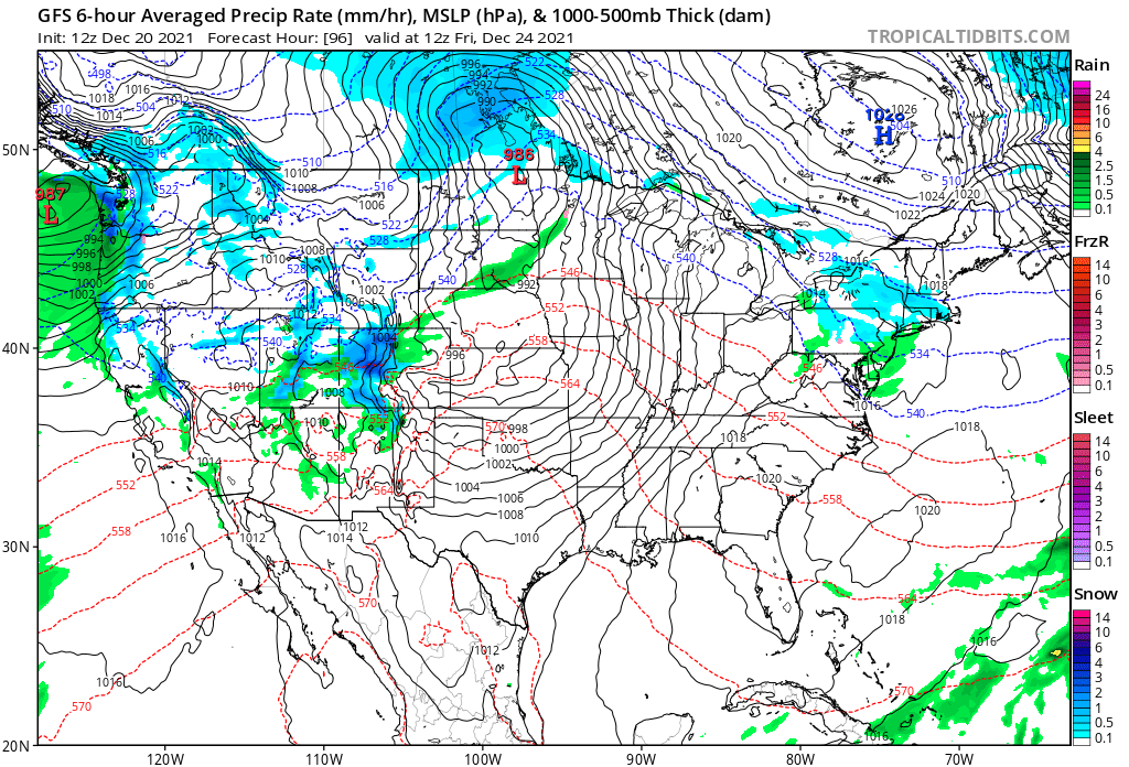
Ahead of a developing front, southerly winds will usher in very mild air for thus time of the year into the Midwest. I expect some record warmth in the Plains looking at these forecast max values for 12/24:

For Christmas a frontal passage will begin to cool the Upper Midwest, but the South will see more record warmth in the 70’s to near 80°F:

To my recollection going back into the 1960’s, I don’t remember a Christmas forecast this warm, so given the state of climate change, we probably are looking at a near record warm Christmas Eve and Christmas Day compared with data compiled in recorded history. Of course, I’ll report a verification of this shortly after the big holiday.
Obviously, outside of the West, snow and snow cover for white Christmas lovers will be at a premium. Here is more on that story from the Washington Post. Today I’m presenting just part of this article, which in invite all to read in its entirety from the following link:
https://www.washingtonpost.com/weather/2021/12/18/white-christmas-chances-climate/
This year’s grim white Christmas chances

Temperature differences from average over the past 20 days over the Lower 48. (WeatherBell)
The Lower 48 has already seen three bouts of record-breaking warmth this month, with many areas on track for their warmest December on record. Accordingly, snow cover is considerably below normal across the country. As of Saturday, about 29 percent of the nation has snow cover compared to a more typical value of 37 percent. Only four years since 2003 have had less extensive snow cover than this one.
Snow may vanish for years at a time in Mountain West with climate warming
Computer models for the period around Christmas project a fourth burst of warmth that will probably greatly limit snow potential and melt away previous snow cover in a number of areas.

Temperature difference from normal predicted on Christmas morning from the European modeling system. (WeatherBell)
While the specifics are subject to change, the temperature forecast for Christmas over the Lower 48 looks much like it has so often this month. Model simulations show a high likelihood of milder than average weather over much of the country, with abnormally warm weather in the central states, especially the Southern Plains. Chillier-than-normal conditions are isolated to the very north central U.S. and perhaps parts of California.
The European modeling system’s simulation of snow cover on Christmas morning only shows at least an inch of snow in northern New England, the northern Great Lakes and Upper Midwest, and Mountain West. The Mountain West will, by far, be the most wintry part of the country, especially in the Cascades and Sierras, where a succession of storms will have unloaded massive amounts of snow.

Predicted snow depth on Christmas morning from the European modeling system. (WeatherBell)
A number of places that typically have white Christmases, such as large parts of Iowa, Wisconsin and even southern Minnesota, which recently experienced tornadoes, may well awaken to bare ground on Dec. 25.
Welcome to the new normal.
Article by:

By Jason Samenow is The Washington Post’s weather editor and Capital Weather Gang’s chief meteorologist. He earned a master’s degree in atmospheric science and spent 10 years as a climate change science analyst for the U.S. government. He holds the Digital Seal of Approval from the National Weather Association. Twitter
Here are some “ET” reports from Monday:
Here are more climate and weather news from Monday:
(As usual, this will be a fluid post in which more information gets added during the day as it crosses my radar, crediting all who have put it on-line. Items will be archived on this site for posterity. In most instances click on the pictures of each tweet to see each article. The most noteworthy items will be listed first.)
Now here are some of today’s articles and notes on the horrid COVID-19 pandemic:
(If you like these posts and my work please contribute via the PayPal widget, which has recently been added to this site. Thanks in advance for any support.)
Guy Walton “The Climate Guy”