The main purpose of this ongoing blog will be to track planetary extreme, or record temperatures related to climate change. Any reports I see of ETs will be listed below the main topic of the day. I’ll refer to extreme or record temperatures as ETs (not extraterrestrials).😉
Main Topic: Update of Heatwave Apothis to Start a Historic Torrid Week
Dear Diary. After looking at model data this weekend I fear that we are staring in the face of a historic, very prolonged heatwave. Will it get to be as bad as the Pacific Northwest/British Columbian heatwave from last year in which the temperature got up to 120°F for the first time in recorded history in Canada?
Admittedly, I’m not going to be able to keep up with all of the myriad of “ET” stats created by Apothis. I do have help, though. For a recap of those from the prior day, and more meteorological thinking on what is to come, please Google the Capitol Weather Gang:
To start a new week, as of this Sunday, CAT3 Apothis was getting serious across the nation’s mid-section:

The heat dome in association with Apothis this morning was not that impressive:

By Tuesday the heat dome will be forced eastward and build significantly into the Southeast by a very strong Pacific system:

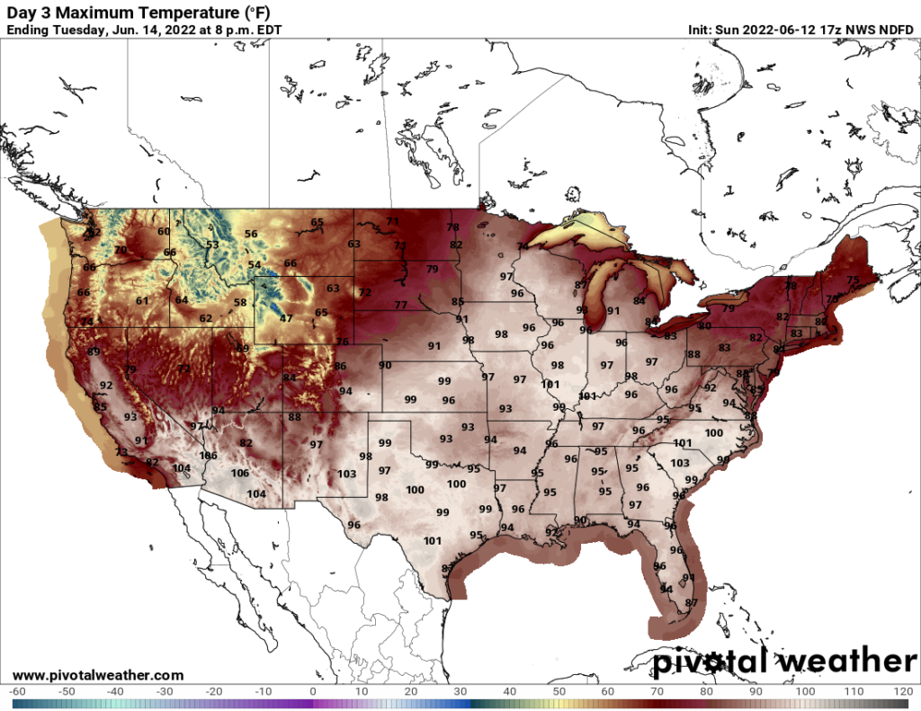
Apothis will build over much of the South, East, and Midwest through the end of this week:

An incredible northward surge of heat will make life miserable for persons without air conditioning in the Great Lakes and southern Canadian area by Tuesday:

The majority of records to fall from Apothis should come from more northern locations this week since many daily records are below a lower bar to reach of 95°F across the Upper Midwest:
I’m thinking that Apothis will become historic in nature, getting to my CAT4 level, but will we see a deadly CAT5 that has the potential to kill hundreds as happened in the Pacific Northwest last year? I’m hoping that we don’t see a 600-decameter monster as the heat dome pulses, waxing and waning through the end of June.
Speaking of the Capital Weather Gang. Here is their latest report from Saturday, which I’m using for today’s main topic:
https://www.washingtonpost.com/climate-environment/2022/06/11/heat-wave-southwest-california-east/
Extreme heat sets records from California to Texas and will swell east
Triple-digit highs set records in Houston, San Antonio, Albuquerque, Las Vegas and Phoenix on Friday

June 11, 2022 at 12:56 p.m. EDT

Forecast highs Saturday from the National Weather Service. Boxed values are predicted records. (WeatherBell)
Scores of high-temperature records were established Friday, from Texas to California’s Central Valley, as a relentless heat wave continued to build. The heat is poised to expand into the Midwest and Southeast over the coming days.
10 steps you can take to lower your carbon footprint
On Friday, triple-digit highs set records in major population centers across the Southwest, including Houston, San Antonio, Austin, Albuquerque, Las Vegas and Phoenix.
The National Weather Service in Phoenix described the heat as “extreme and deadly.”
Many of these areas are forecast to be equally hot on Saturday, as the heat begins to expand eastward. Nearly 60 million Americans are under heat advisories or excessive heat warnings.

A heat advisory covers almost the entirety of the states of Texas and Oklahoma and even extends into northwest Louisiana and parts of western Arkansas. Heat advisories and excessive heat warnings also cover parts of New Mexico, Arizona, Utah, Nevada and California.
By Sunday, the core of the heat is forecast to shift from California and the Southwest toward the Southern Plains. By Monday, it will ooze into the Central Plains and Midwest before reaching the Ohio Valley and Southeast on Tuesday and Wednesday.
What has been a dry heat in the Southwest will evolve into a more sultry nature east of the Rockies, as moist air is drawn north from the Gulf of Mexico. This will increase the risk of heat-related illnesses.
Early next week, cities from St. Louis to Charlotte will endure punishing heat, with highs from 95 to 100 that will feel like 100 to 110 when factoring in oppressive humidity.
Records set on Friday
Death Valley — home to the highest temperatures ever observed worldwide — soared to a simmering 123 degrees Friday. That mark set a June 10 record and was the fourth-earliest the mercury has climbed that high on record in the United States, according to Maximiliano Herrera, a climatologist who tracks world weather extremes.
Other record highs set Friday include:
- Phoenix: 113
- Las Vegas: 109
- Paso Robles, Calif.: 106
- Stockton, Calif.: 105
- Bishop, Calif.: 103
- Austin: 103
- Victoria, Tex: 102
- San Antonio: 101
- Albuquerque: 100
- Grand Junction, Colo.: 100 (tie with 1981)
- Houston: 98
- Reno, Nev.: 96 (tie with 1918)
- Eureka, Nev.: 95
- Flagstaff, Ariz.: 87 (tie with 1910)
In addition to all of these record highs, numerous locations in the region have set records for warm overnight lows. In Phoenix, it was still 100 degrees at midnight Saturday.
“With heat waves, the overnight temperatures are the most dangerous, as your body relies on cooler temperatures while it’s sleeping to recover,” wrote the National Weather Service office in Las Vegas in a forecast discussion. “Without this cooling, your body is less equipped to handle the scorching daytime heat, leading to increased incidences of heat exhaustion or heat stroke.”
Saturday’s heat
The worst of the heat on Saturday will be concentrated from Texas to the Desert Southwest.
“The heat the past few days has already proven to be a major societal impact, and possibly even deadly, and it is not done yet,” the Weather Service office in Phoenix wrote.
Phoenix is forecast to hit 114, a record for the date; Las Vegas is predicted to reach 110, also a record.
Death Valley may match Friday’s high of 123, setting a record for a second straight day.
Abnormally hot weather has punished many parts of Texas since the second half of May, and Saturday may be one of its hottest days yet. Forecast highs include:
- Abilene: 107
- Lubbock: 105
- San Antonio and Austin: 104
- Dallas: 103
- Houston: 100
While it will be more of a dry heat in interior parts of Texas, humidity will increase nearer the Gulf Coast, making the heat even more dangerous.
“Heat safety will be critical this weekend — remaining hydrated, applying sunscreen, checking in on elderly or ill family and friends, and avoiding strenuous activity during the hottest parts of the day can all combat preventable heat-related illnesses,” wrote the Weather Service office in Houston.
It will also remain hot in California’s Central Valley but will be several degrees cooler than Friday. Sacramento hit 104 on Friday; Saturday’s forecast high is 101. By Sunday, it’s a much more tolerable 85.
The heat Sunday into next week

While the heat gradually eases over California and the Southwest on Sunday and beyond, it will persist in Texas and the Southern Plains and expand eastward:
- Sunday’s hottest weather will range from Texas to Kansas, with widespread triple-digit highs. Phoenix could top 110 degrees one more day, while eastern New Mexico and eastern Colorado will also swelter. Highs well into the 90s will expand across the Midwest, including St. Louis and Kansas City, and the Southeast.
- Monday’s hottest weather will be concentrated in the Plains and Midwest. Highs over 100 will expand from Texas to Kansas, while highs from at least 95 to 100 sprawl over much of the Midwest and Southeast. St. Louis could hit 100, with upper 90s in Kansas City, Springfield, Ill., Charlotte, and Columbia, S.C. Factoring in the humidity, it will feel 5 to 10 degrees hotter.
- Tuesday’s hottest weather will stretch from the Midwest to the Ohio Valley and the Southeast, with widespread mid-to-upper 90s — including Minneapolis, Des Moines, Chicago, St. Louis, Nashville, Cincinnati, Roanoke and Raleigh. Again, oppressive humidity levels will make it feel up to 10 degrees hotter.
- Wednesday’s hottest weather will again stretch from the Midwest to the Ohio Valley, even expanding into the Great Lakes. Highs in the mid-to-upper 90s could reach Detroit, Ann Arbor, Mich., and Cleveland.
While some relief from the heat will arrive in parts of the Midwest and Ohio Valley later in the week, the responsible zone of high pressure, or heat dome, will return to the southern and central United States into next weekend. In other words, there is no end in sight to anomalously high temperatures occupying considerable parts of the country.
Human-caused climate change is supercharging heat waves like this one, making them more intense and long-lived.

By Jason Samenow Jason Samenow is The Washington Post’s weather editor and Capital Weather Gang’s chief meteorologist. He earned a master’s degree in atmospheric science and spent 10 years as a climate change science analyst for the U.S. government. He holds the Digital Seal of Approval from the National Weather Association. Twitter
Another take:
Here are some “ET’s” recorded from around the planet the last couple of days, their consequences, and some extreme temperature outlooks:
Here is more May 2022 climatology:
Here is more climate and weather news from Sunday:
(As usual, this will be a fluid post in which more information gets added during the day as it crosses my radar, crediting all who have put it on-line. Items will be archived on this site for posterity. In most instances click on the pictures of each tweet to see each article. The most noteworthy items will be listed first.)
(If you like these posts and my work please contribute via this site’s PayPal widget. Thanks in advance for any support.)
Guy Walton “The Climate Guy”