The main purpose of this ongoing blog will be to track planetary extreme, or record temperatures related to climate change. Any reports I see of ETs will be listed below the main topic of the day. I’ll refer to extreme or record temperatures as ETs (not extraterrestrials).😉
Main Topic: Monday Update on Heatwave Apothis
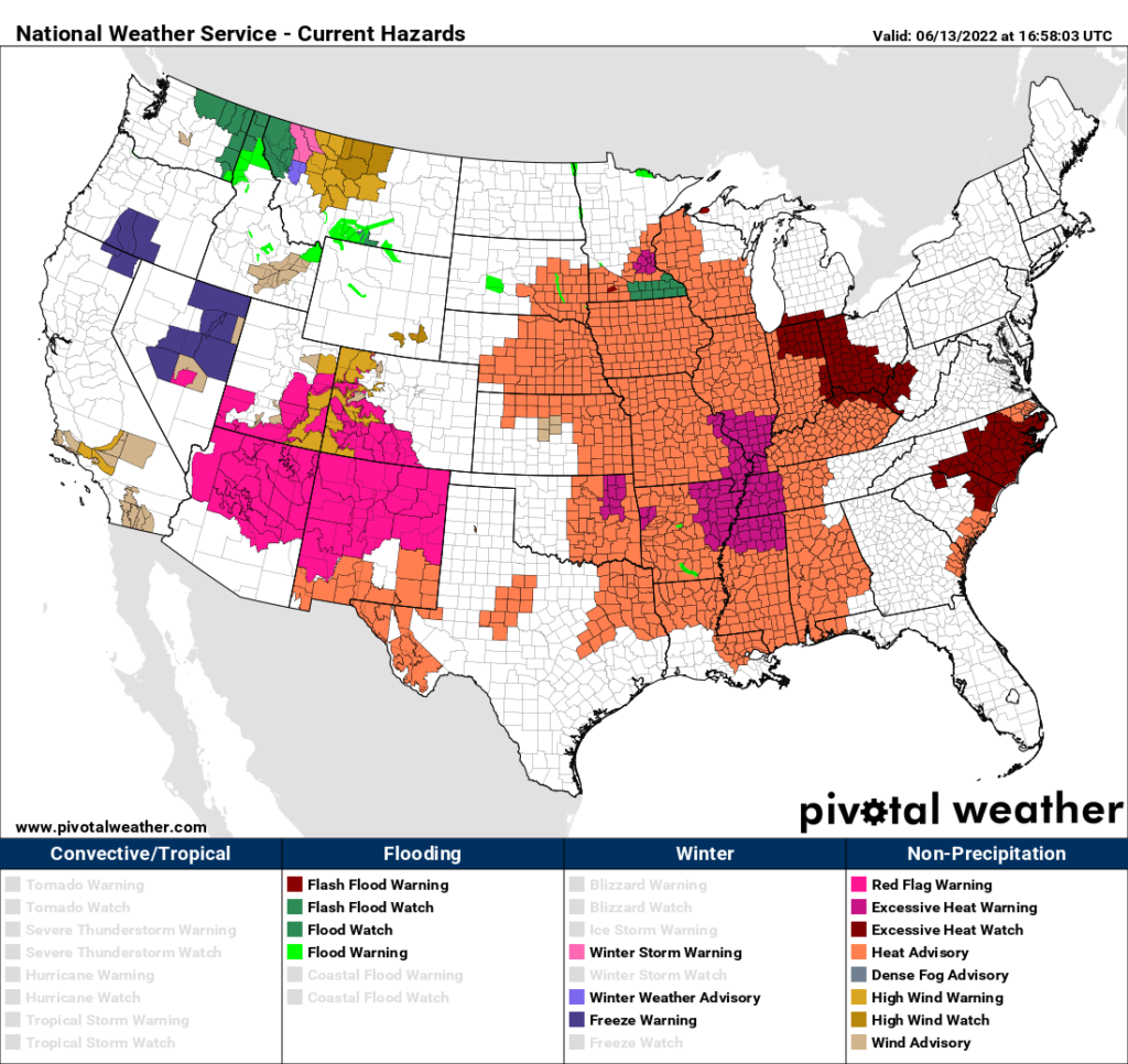
Dear Diary. After assessing the situation for the past 24 hours, it’s becoming apparent that Heatwave Apothis might not go down in history with an extreme number of all-time records, at least not this week. Rather, the thing will be known for its longevity as day after day for what could be weeks across mostly the southern U.S. and Midwest we see high heat index values, leading to a plethora of National Weather Service heat advisories. Here is what we currently have:

The good news here is that slightly cooler temperatures along with lower humidity levels, compared with those of Sunday, are occurring across the south-central states, so advisories have mostly been dropped across Oklahoma and Texas. The bad news is that low humidity there with near record temperatures will only reinforce a historic western drought, feeding into the heat dome from Apothis. Also, as expected, dangerous heat is making inroads towards the north and east where watches are posted.
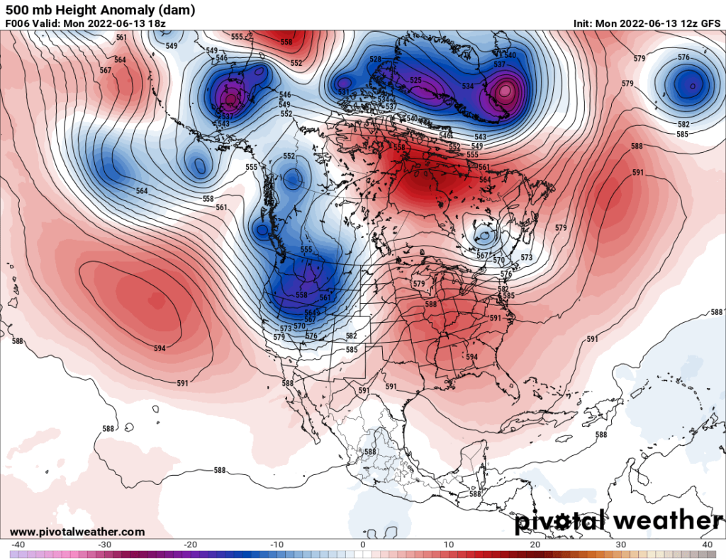
Here is the heat dome as of this afternoon:

As of Monday, 500 millibar heights are very high for mid-June across the Southeast. We are starting to see a 594-decameter core, which is a signature for a string heat dome.
One item I did not mention yesterday was a dreaded “ridge rider pattern.” This occurs across the northern extent of a heat dome where the atmosphere gets very unstable and uncapped just enough to produce severe storms, which ride or move southeast on the periphery of central U.S. heat domes. Today’s orientation of the ridge, or heat dome, looks favorable for a derecho. Don’t forget, we had a very damaging derecho across the Midwest last year. Here is the latest Storm Prediction Center outlooks for today:

For a wrap on Apothis, and records that the thing produced over the weekend, here is the latest article from the Washington Post:
https://www.washingtonpost.com/climate-environment/2022/06/13/heatwave-records-storms-derecho/
Record-setting heat wave expands east, over 100 million under alerts
Highs approaching the triple digits will sprawl from Denver to Charleston through midweek, while dangerous storms may form along northern edge of heat
By Matthew Cappucci and
June 13, 2022 at 12:45 p.m. EDT

A look at high temperatures predicted for Tuesday. (Pivotal Weather) (Pivotal Weather)
A massive heat wave that has set scores of temperature records from Texas to California is swelling into the eastern United States. Over 100 million Americans from the Gulf Coast to the Great Lakes are under heat alerts through the middle of the week as temperatures soar toward the triple digits.
10 steps you can take to lower your carbon footprint
Oppressive humidity levels will make it feel 5 to 15 degrees hotter, producing heat index values from 100 to 115 degrees over a large swath of the central and eastern Lower 48.
‘Vomiting. The loss of strength’: Southwest heat drives health fears
Heat advisories or excessive heat watches and warnings cover the entirety of Arkansas, Mississippi, Kentucky, Missouri, Iowa, Illinois and Indiana and parts of more than a dozen other states.

National Weather Service alerts in effect. (PivotalWeather)
The National Weather Service forecasts temperatures could challenge records in more than 100 cities through Wednesday from Denver to Charleston.
The heat is projected to be most prolonged and intense in the middle of the nation.
Relentless heat is forecast in St. Louis, where the mercury is predicted to hit at least 100 daily each of these days — with heat index values up to 113. It is under an excessive heat warning for “dangerously hot conditions,” according to the National Weather Service.
The sultry air is simultaneously fueling the risk for severe thunderstorms along the northern periphery of the heat wave. The Weather Service is carefully monitoring the potential for the development of a violent complex of storms that could sweep from the Upper Midwest into the Ohio Valley and the Mid-Atlantic on Monday afternoon into early Tuesday.
Forecasts into next week call for the punishing heat wave to persist over the central states. Heat waves such as this are typical staples of summer, but their impacts are made more severe and prolonged by human-caused climate change.
Where the heat is now, where it’s headed and how long it could last

A heat dome parked over the Tennessee Valley. (WeatherBell) (WeatherBell)
The excessive heat is the result of an intense and sprawling zone of high pressure, sometimes referred to as a heat dome.
The dome, centered over the Southwest on Saturday, has since shifted east. On Monday, it was hovering over the lower Mississippi Valley, placing much of the eastern half of the country, aside from the Northeast, in its crosshairs. By Wednesday, it will shuffle toward Nashville before oozing west again.
The science of heat domes and how drought and climate change make them worse
On Monday, readings above 100 degrees are forecast for most of Texas, with upper 90s from the Corn Belt all the way east to the Carolinas. Record-challenging highs near 100 are forecast in Denver, Dallas, Omaha, Memphis and Charlotte among many other locations.

Upper 90s to near 100 could make it as far north as Minneapolis on Tuesday, with 98 in Atlanta, 97 in Chicago and 101 degrees in Raleigh. Columbia, S.C. could hit a whopping 102 degrees.
The combination of heat and humidity in Charlotte on Tuesday and Wednesday — producing heat index values near 110 — may be the most intense there since 2010.
On Wednesday, upper 90s will be ubiquitous from the central Plains and Texas through the eastern Great Lakes, Midwest and interior Mid-Atlantic and Appalachians, as well as the Southeast. Records could threaten the zone from roughly Flint, Mich. through Columbus and Knoxville to Atlanta.
The heat isn’t going anywhere any time soon. It may shift west a bit and consolidate over the central states late this week into the weekend. The Weather Service’s Climate Prediction Center projects a continuation of above normal temperatures in the central states over the next two weeks.

A look at the Climate Prediction Center’s temperature outlook for the next 8 to 14 days. (NOAA/CPC) (NOAA/CPC)
Heat fuels storm threat
Along the northern periphery of the heat dome, where the sweltering heat meets cooler air, the resulting temperature contrast is anticipated to brew severe thunderstorms. Storms were already apparent midday Monday in the Upper Midwest and Great Lakes.
Concern was growing that a bow echo, or curved squall line capable of producing damaging straight-line winds, would organize and propagate south and east Monday afternoon and night through the Upper Midwest and Ohio Valley. The Weather Service’s Storm Prediction Center placed the zone from Wisconsin to northern West Virginia at greatest risk from this possible thunderstorm complex, or mesoscale convective system (MCS).
“It appears possible that a long-lived bowing MCS could result in a swath of considerable wind damage along this corridor,” wrote the Storm Prediction center, which also cautioned large hail and a few tornadoes are possible. Cities in the elevated risk corridor include Chicago, Milwaukee, Detroit, Indianapolis, Columbus, Cleveland and Pittsburgh.
There’s an outside chance the MCS meets the criteria of a derecho, which is a fast-moving, extensive, long-lived and violent thunderstorm complex.
Derecho season: Why you should be aware of these potentially devastating windstorms

A high-resolution model simulation of what could evolve into a significant windstorm for parts of the Midwest and interior Mid-Atlantic. (WeatherBell) (WeatherBell)
It’s unclear if the storm complex will survive its trip over the Appalachians on Monday night, and what the repercussions would be for Washington and Baltimore. but it’s worth watching the area for the late overnight into early morning Tuesday time frame.
Thereafter, another such complex could develop over the Upper Midwest or Great Lakes and shift into the interior Northeast late Wednesday into Thursday.
Records set so far
As the heat spread over the zone from Texas to California’s Central Valley late last week into the weekend, it set a slew of records.
Phoenix nabbed a trio of daily high temperature records in a row — 113 on Friday, 114 on Saturday, and 112 degrees on Sunday. The average high there this time of year is about 105 degrees.
On Friday, the morning low in Phoenix didn’t dip below 87 degrees, meaning that, when factored in with the afternoon high of 113, the day’s average temperature was 100 degrees. That’s the earliest triple-digit daily average temperature on record at Phoenix.
Las Vegas hit 109 on Friday and Saturday, tying or breaking records, and Salt Lake City made it to 102 on Saturday and 103 degrees on Sunday. That also broke records.
Denver soared to 100 on Saturday, a tie for its earliest instance on a record touching the century mark.

A look at temperature differences from normal over the next week or so. (WeatherBell) (WeatherBell)
In Texas, sweltering days and sultry nights set dozens of records. Dallas saw a morning low of 80 degrees on Sunday, a record warm minimum temperature. Elevated overnight temperatures often play an even greater role than daytime highs in amplifying heat stress on the body and contributing to heat-related illnesses and fatalities of vulnerable populations. Dallas then hit a record high of 103 degrees Sunday afternoon.
Abilene, Tex. saw three daily records in a row — 102 degrees on Friday, 108 on Saturday and 109 by Sunday. San Antonio also tied or broke records those days at 101, 104 and 105 degrees respectively, as did Austin, at 101 degrees Thursday, 103 degrees Friday, 104 on Saturday and 105 by Sunday.
In Houston and Galveston, the heat has been overlapping with oppressive humidity, contributing to heat indexes in the 105 to 110 degree range.
It could be worse, however — southeast Oklahoma saw heat index values in the incredible 120-degree range Saturday. That was because of air temperatures around 105 combined with dew points, a measure of humidity, in the upper 70s to near 80.

By Matthew Cappucci Matthew Cappucci is a meteorologist for Capital Weather Gang. He earned a B.A. in atmospheric sciences from Harvard University in 2019, and has contributed to The Washington Post since he was 18. He is an avid storm chaser and adventurer, and covers all types of weather, climate science, and astronomy. Twitter

By Jason Samenow Jason Samenow is The Washington Post’s weather editor and Capital Weather Gang’s chief meteorologist. He earned a master’s degree in atmospheric science and spent 10 years as a climate change science analyst for the U.S. government. He holds the Digital Seal of Approval from the National Weather Association. Twitter
Here are some “ET’s” recorded from around the planet the last couple of days, their consequences, and some extreme temperature outlooks:
Here is more May 2022 climatology:
Here is more climate and weather news from Monday:
(As usual, this will be a fluid post in which more information gets added during the day as it crosses my radar, crediting all who have put it on-line. Items will be archived on this site for posterity. In most instances click on the pictures of each tweet to see each article. The most noteworthy items will be listed first.)
(If you like these posts and my work please contribute via this site’s PayPal widget. Thanks in advance for any support.)
Guy Walton “The Climate Guy”