The main purpose of this ongoing blog will be to track planetary extreme, or record temperatures related to climate change. Any reports I see of ET’s will be listed below the main topic of the day. I’ll refer to extreme or record temperatures as ET’s (not extraterrestrials).😉
Main Topic: Science Learned from Hurricane Ian
Dear Diary. Before the 2022 Atlantic Hurricane season fades into history, it is worth noting new science learned from its most infamous hurricane, Ian. I write this statement noting that meteorological models indicate that Ian will be the last landfalling U.S. hurricane of 2022. Thank goodness. A cold fall jet stream pattern in the East should keep organized tropical activity well away from the States through the end of October. Fingers crossed, though, because stranger things have happened with quick pattern changes.
In any case, meteorologist Jeff Beradelli has written a nice summary on science learned from observing deadly Hurricane Ian, which was influenced by climate changed above average Gulf of Mexico sea surface temperatures. I teased him a bit after his move to Tampa Bay since he is a big proponent of on-air climate change education, and his new city had some worse weather after his move, which appeared to be climate change related. Ever since moving to Tampa, that city has had a lot of record heat and nearly got struck by a disastrous hurricane. In retrospect, after models initially forecast a Tampa landfall, it was better for Fort Myers to get struck by Ian than Tampa. Don’t tell that to the people of Fort Myers, though. Eventually, climate change will make all of us suffer.
Here is Jeff’s summary:
https://www.wfla.com/weather/tracking-the-tropics/hurricane-ians-stunning-science-lessons/
Hurricane Ian’s stunning science lessons
by: Jeff Berardelli
Posted: Oct 5, 2022
TAMPA, Fla. (WFLA) — Category 4 Hurricane Ian has proven to be a life-changing storm for the residents of Southwest Florida who, like those who lived through Hurricane Andrew in Miami, will now refer to Ian as a turning point in their lives – their life before Ian and their life after Ian.
Scientists understood just how impactful the storm would be in numbers, but even for those same meteorologists well-versed in storm damage, the reality of what those numbers would translate to on the ground was hard to visualize ahead of the storm.
As hurricane Ian lumbered its way towards the coast, Hurricane Hunters were out in the storm while it was undergoing rapid intensification. During that phase, the storms produce a lot of turbulence and the scientists reported being shot upwards 700 feet in an instant.
Nick Underwood described it as the roughest flight of his career.
When hurricanes rapidly intensify, they are often out of balance. Energy is being fed into the system from the hot water underneath, as intense vertical motion inside of exploding thunderstorms. The hurricane will then convert that energy from vertical motion into horizontal motion, by increasing the winds whipping around the center. However before that conversion takes place the hurricane is not in balance and chaotic, turbulent motion prevails.
When meteorologists see a strong burst of thunderstorms (convection) around the center of the storm, they are keenly aware that the storm may be about to strengthen. A sure sign that the system is getting ready to go boom is lightning near its core. Ian was a prolific lightning producer right before landfall, with 1,000 strikes in an hour’s time – a feat rarely, if ever, matched.
Ian was that rare hurricane which will be remembered for all three hazards: wind, rain and surge. But when the tallies are complete, the most catastrophic impacts will be from surge. And although the official maximum storm surge number is not known yet, it will likely be over 10 feet, perhaps closer to 15 feet, near Fort Myers Beach.
Anyone who follows hurricanes knows the worst surge is on right side of the storm. For Ian that was the southeast side, and that landed squarely on Sanibel Island and Fort Myers Beach. But there was another phenomenon present which aided the surge – the contour of the coastline.
As the below visual displays, the coast comes to a right angle between Bonita Springs and Sanibel Island. That helped funnel the water into a tight corner, forcing the Gulf of Mexico water upwards, spiking surge.
The Tampa Bay area experienced the opposite – reverse storm surge. Many remember seeing this in Tampa Bay during Hurricane Irma a few years ago, but this time the effect was enhanced because Ian was stronger.
The same counterclockwise flow around Ian which forced water onto the beaches of southwest Florida also helped pull water out of Tampa Bay coastal areas. Video from the Gulf of Mexico in Holiday, near the Pasco-Pinellas county line, taken by local Captain Ed Walker shows nothing but land on the flat where water normally is.
The visual below illustrates how reverse storm surge works. At the apex of Tampa Bay, near downtown Tampa, tide levels fell 7.5 feet below the forecast level.
For areas away from the coast, Ian will be remembered for its extraordinary rainfall. The heaviest rain was on the northwest side of the track from North Port northeast to Wauchula and Fort Meade. Rainfall tallied around 20 inches in 24 hours along this path and 13 inches fell in just 6 hours. Both measurements are considered a one-in-1,000 year event, according to NOAA’s data tool.
These rare rain events are becoming more common in a warming world. The science is clear on the connection between climate change and hurricanes. In the case of Ian, a rapid attribution study found Ian’s rain increased 10% by climate change.
The rainfall overwhelmed our rivers and led to catastrophic flooding in Polk, Hardee, DeSoto, Manatee and Sarasota counties. The event ranked second, only to Hurricane Harvey in Texas, in terms of 24-hour areal coverage of rainfall.
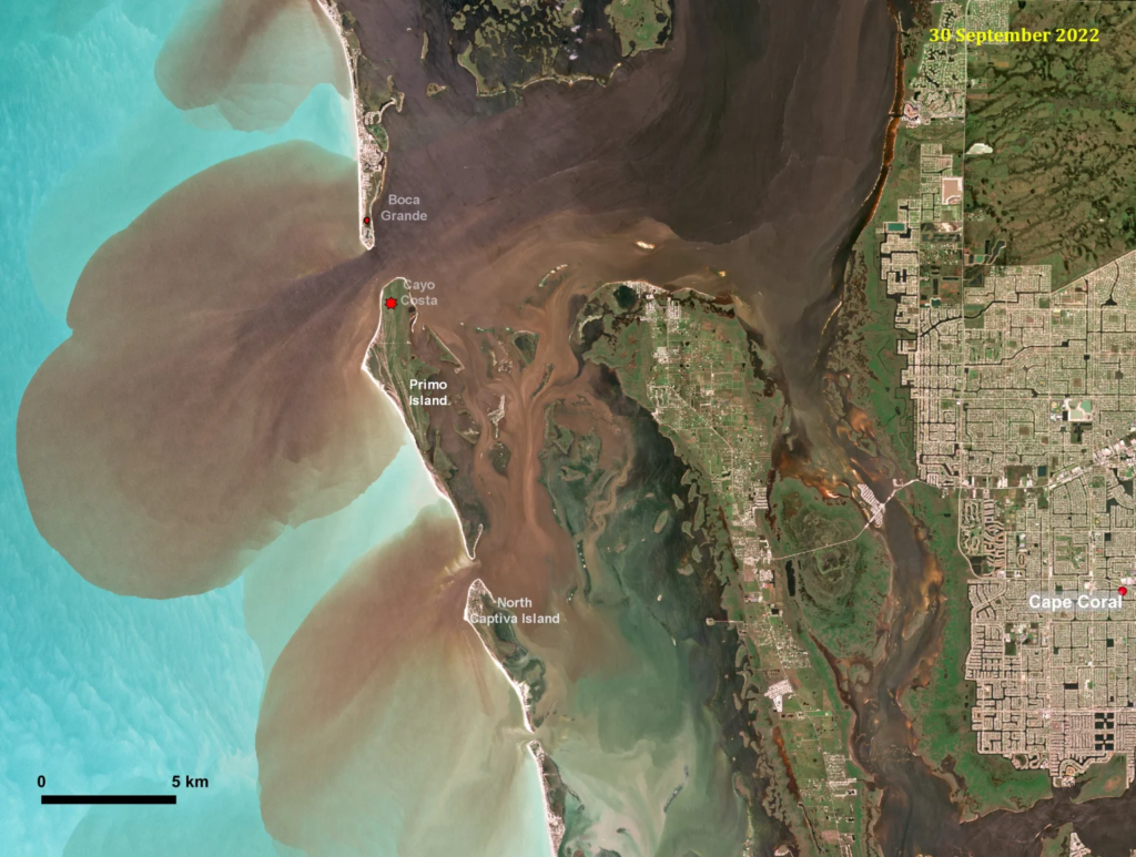
Some of the water returned to the Gulf as runoff, but not nearly as emerald green as it typically is. Above is a European Space Agency image taken on Sept. 30 showing sediment plumes streaming into the Gulf waters.
Related:
Here are some “ET’s” recorded from around the planet the last couple of days, their consequences, and some extreme temperature outlooks:
Here is some September 2022 climatology:
Here is more climate and weather news from Sunday:
(As usual, this will be a fluid post in which more information gets added during the day as it crosses my radar, crediting all who have put it on-line. Items will be archived on this site for posterity. In most instances click on the pictures of each tweet to see each article. The most noteworthy items will be listed first.)
If you like these posts and my work please contribute via the PayPal widget, which has recently been added to this site. Thanks in advance for any support.)
Guy Walton “The Climate Guy”