The main purpose of this ongoing blog will be to track planetary extreme, or record temperatures related to climate change. Any reports I see of ETs will be listed below the main topic of the day. I’ll refer to extreme or record temperatures as ETs (not extraterrestrials).😉
Main Topic: Mexico Has Had a Hot Year Culminating in the Landfall of Otis
Dear Diary. Mexico has been having the hottest last few months in their history due to climate change and a ramping up historically strong El Niño. I became laser focused on updating record statistics after seeing this note from Maximiliano Hererra a week ago:
September 2023 in #Mexico had an average temperature of 26.4C,+2.6C vs 1991-2020 norm and was the HOTTEST ON RECORD
— Extreme Temperatures Around The World (@extremetemps) October 17, 2023
Hundreds of records were broken allover the country
Last months in Mexico were insane
-Hottest June
-Hottest July
-Hottest August
-Hottest summer
-Hottest September pic.twitter.com/Znzk2jSL4P
Here are the results of my updates as far as daily record counts go. This decade’s warmth stands out like a very sore thumb:
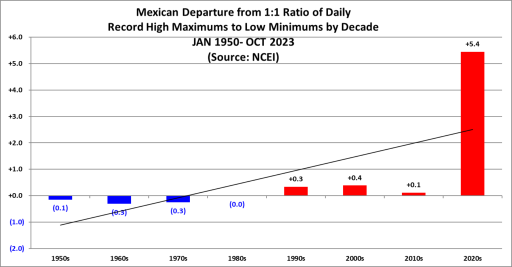
Here are the current daily record counts per decade, which have gone into the prior chart:


Here are the current daily record counts per decade, which have gone into the prior chart:

Very detailed statistics breaking down this data can be found in the next three links. All of my data has been updated through October 2023:
NCEI Mexican Daily Record Count Archive – Guy On Climate
NCEI Mexican Monthly Record Count Archive – Guy On Climate
NCEI Mexican All-Time Record Count Archive – Guy On Climate
Very unfortunately, the other shoe to drop from all of this record heat occurred last night:
Make that CAT5 for #Hurricane #Otis. This situation is dire for @Acapulco. @ClimateOfGavin https://t.co/ePvOcd4mSO
— Guy Walton (@climateguyw) October 25, 2023
It will take a while to understand all the circumstances that allowed Hurricane Otis to explode into a Category 5 storm.
— Dr. Robert Rohde (@RARohde) October 25, 2023
But persistent very warm water in the region almost certainly played a role.
Map of regions with record and near-record warmth in September. pic.twitter.com/eaI14m5xm9
Otis was the strongest hurricane to have ever roared ashore on the west coast of Mexico. There was some very bad luck here. The system hit the famed resort city of Acapulco even though it more likely could have moved into an unpopulated area along thousands of miles of coast…almost like a dart hitting a bullseye. Maybe nature is trying to wake us up.
In any case, meteorological models did a horrible job in association with forecasting the strength of Otis. Here is a summary of Otis from the Washington Post:
This is a KEY stat from Jason’s and my writeup on #Otis.
— Matthew Cappucci (@MatthewCappucci) October 25, 2023
It is the
• strongest landfalling Pacific Coast hurricane on record
• first Pacific Cat-5 to hit Mexico
• fastest-intensifying E. Pac. hurricane on record (TS. to Cat-5 in 12 hours)
We’re re-writing the rule books. pic.twitter.com/ilkaoABO1k
Acapulco, Mexico went to sleep Monday night expecting a breezy Tuesday with gusts of 40-50 mph.
— Matthew Cappucci (@MatthewCappucci) October 25, 2023
Instead they got Mexico’s first Pacific Cat. 5 — w/160 mph winds.
There is no precedent. Tropical storm to Cat. 5 in 12 hours. Strong #climate link to RI.https://t.co/fAYlLurGFh
The intensity of Hurricane Otis shocked forecasters as it grew to Category 5 – The Washington Post
How Hurricane Otis stunned forecasters with its leap to a Category 5
Forecasters didn’t even anticipate Otis would become a hurricane. Then it broke all-time records.
By Matthew Cappucci and Jason Samenow
October 25, 2023 at 11:38 a.m. EDT

Hurricane Otis at peak strength on Tuesday night. (RAMMB/CIRA)
When residents of Acapulco, Mexico, went to bed on Monday, Wednesday’s forecast called for gusty winds and some downpours. Otis, a run-of-the-mill tropical storm, was expected to only “gradually strengthen” en route to the coast. Instead, Otis intensified faster than any other eastern Pacific storm on record Tuesday and became the strongest hurricane to ever strike Mexico slamming Acapulco as a “potentially catastrophic Category 5.”
Hurricane Otis live updates
 (The Washington Post)
Hurricane Otis intensified and made landfall overnight near Acapulco, Mexico, as a Category 5 hurricane with 165 mph winds. Follow our live updates and see the latest maps tracking Hurricane Otis’s projected path.
As winds catapulted to Category 5 strength Tuesday evening, shocked forecasters at the National Hurricane Center described the storm’s extreme intensification as a “nightmare scenario” and “extremely dangerous situation.” Nobody saw it coming — but with human-caused climate change warming the planet’s oceans, this situation could become more frequent.
On Monday night, most computer models only simulated Otis’s top winds reaching 60 mph (these forecasts increased some on Tuesday as the storm showed signs of rapidly gaining strength). Instead, Otis came ashore near Acapulco with 165 mph winds, surely catching most of the city of 1 million off guard.
On X, formerly Twitter, meteorologists described the forecast as “an almost incomprehensible miss,” “a fail of epic proportions” and “just a catastrophic failure.”
Hurricane warnings weren’t issued for southern Mexico’s western coast until 2 a.m. local time Tuesday, about 24 hours before landfall — and, even then, the forecast was for a Category 1. The 9 a.m. Hurricane Center forecast on Tuesday — about 15 hours before landfall — still called for a Category 1. Not until 3 p.m., less than 12 hours before landfall, did the forecast increase to a Category 4.
Here are the HWRF, HMON and HAFS-A forecasts for about now from 24hrs ago (Tues 00z) versus reality. A fail of epic proportions with #hurricane #otis (imagery via @TropicalTidbits) https://t.co/NYcoPMx0Rj pic.twitter.com/8blPUVAwJL
— James Reynolds (@EarthUncutTV) October 25, 2023
Just to emphasize how poorly hurricane & global models performed for Hurricane Otis… here's the intensity forecasts initialized 24 hours ago, with the dotted black line showing verification: pic.twitter.com/DN5pf7lcOS
— Tomer Burg (@burgwx) October 25, 2023
While hurricanes can surprise meteorologists, a wind forecast error of nearly 100 mph is highly unusual. But some climate scientists have warned that extreme rapid intensification, made more likely by the effects of human-caused climate change and warming oceans, will lead to more unpredictable storms.
In 2017, MIT hurricane scientist Kerry Emanuel published a paper titled “Will Global Warming Make Hurricane Forecasting More Difficult?” In it, he argued that instances of extreme rapid intensification could be up to 20 times more common by the end of the 21st century.
Otis careened from a tropical storm to Category 5 strength in 12 hours, and its peak winds increased 115 mph in 24 hours. That’s around a threshold that Emanuel wrote was “essentially nonexistent in the late twentieth-century climate” but increasingly probable in the current warming climate.
From #tropical storm to Category 5 #hurricane in 12 hours Tuesday.
— Jonathan Erdman (@wxjerdman) October 25, 2023
(#Otis satellite loop kudos: @chrisdolcewx) pic.twitter.com/FLgRvAqeyn
Just this week, a study documented substantial increases in rapidly intensifying Atlantic storms over the past several decades. “The increased likelihood for hurricanes to transition from weak storms into major hurricanes in 24 hours or less was particularly striking,” Andra Garner, the study’s author, told The Washington Post.
Strongest landfalling Pacific hurricane on record
Otis’s Category 5 landfall is a first for Mexico, as well as for the entire Pacific coastline of North or South America. While the west coast of Mexico regularly experiences hurricanes, and Otis is the fourth storm to make landfall in Mexico in a month, many of them exhibit a weakening trend before landfall. Otis strengthened up until the very last moment.
It appears that high-altitude winds relaxed more than originally intensified, offering Otis an undisturbed and untapped environment within which to intensify at breakneck pace. It took advantage of bathlike water temperatures around 88 degrees.
#Otis took full advantage of a warm patch of ocean last night… passing over 31°C water on its approach to #Acapulco. The extremely rapid intensification from a tropical storm to a Category 5 hurricane took place over this tiny area. pic.twitter.com/f6fpYD1DOk
— Brian McNoldy (@BMcNoldy) October 25, 2023
Otis’s entire formation came about as an “accident” of sorts; instead of beginning its life as a preexisting tropical wave, it instead was caused when northerly Gulf of Mexico winds were funneled through a gap in between mountain ranges on Mexico’s Isthmus of Tehuantepec. That created a spurt of winds that curled in on itself upon exiting into the Pacific, leading to a small lobe of spin, or vorticity, that began producing thunderstorms.
One of the reasons Otis was so difficult to forecast was its size. As a relatively compact storm, it was particularly sensitive to very localized environmental conditions and prone to rapid fluctuations in strength.
Although hurricane intensity forecasts have improved substantially in recent years, models still have a difficult time predicting rapid changes that can occur in smaller storms.
How does Otis compare to other storms?
Otis’s winds leaped 90 mph in 12 hours, a record for the eastern Pacific. However, its 24-hour intensification falls just shy of Hurricane Patricia in 2015; that storm’s peak winds leaped a record 120 mph in strength in 24 hours. It eventually made landfall as a 150 mph Category 4, weakening as it approached land. But it had become the strongest hurricane on record over the ocean with 215 mph winds.
Aside from Patricia, a half-dozen other hurricanes made landfall on Mexico’s west coast as Category 4s since the 1960s.
It first became clear that Otis was undergoing extreme rapid intensification on Tuesday afternoon, when a Hurricane Hunter flight found staggeringly different conditions inside the storm within two consecutive passes through the eye. Within 80 minutes, the storm’s central air pressure dropped by 10 millibars. In other words, there was 1 percent less air in the middle of the storm. That may not soundlike much, but it signaled an extreme “vacuum” effect within the storm, causing the winds near the ground to accelerate to dangerous levels.
Matt Lanza, a meteorologist who runs The Eyewall, a hurricane commentary website, wrote the forecast for Otis was unacceptable.
“Otis will be studied in the coming months and years to understand why it blew up so quickly, and so powerfully, in such a short period of time,” he said. “In moments like these, forecasters utterly failed the people of Southern Mexico. We must do better.”
Ian Livingston contributed to this report.
Much More:
Sobering damage footage of #Acapulco in the wake of #Otis. 😰
— Philippe Papin (@pppapin) October 25, 2023
My heart goes out to all those that have been affected. Something you never want to see. https://t.co/W0KEhWse5Q
— Dr. Marshall Shepherd (my record is my blue check) (@DrShepherd2013) October 25, 2023
I don't know who shot it originally but Princess Hotel in this video sits exactly where I would have said the strongest winds from #Otis hit. Just SE of #Acapulco & not protected by any mountains. The stretch from here south to the airport will be where the worst destruction is. https://t.co/MHUmrHFv5y pic.twitter.com/qHI5VipSwA
— Bill Karins 💧 (@BillKarins) October 25, 2023
Hurricane Otis' eyewall hit the most heavily developed areas of Acapulco (pop. just over 1 million), perhaps setting a record for the largest number of people ever to experience the eyewall of a Cat 5 storm.https://t.co/lMwyq0hxCr
— Jeff Masters (@DrJeffMasters) October 25, 2023
Scary. First pics of #Acapulco https://t.co/f71btATFYL
— Jeff Berardelli (@WeatherProf) October 25, 2023
Almost 12 hours after landfall, we know so little of what is happening on the ground in #Acapulco. With every hour of the unknown, the magnitude of this tragedy gets worse. #HurricaneOtis pic.twitter.com/08UZhGqWyA
— Bill Karins 💧 (@BillKarins) October 25, 2023
Satellite loop of Hurricane Otis explosively intensifying from a tropical storm to a category 5 hurricane in less than 24 hours, courtesy of the GOES-18 satellite mesoscale floater: pic.twitter.com/ZRxtWBhZ80
— Tomer Burg (@burgwx) October 25, 2023
Such a horrible situation when it comes to #Hurricane #Otis & #Acapulco! How in the world did it intensify so quickly? A tropical storm to #Cat5 in the blink of an eye is NUTS, especially when the models didn’t remotely hint at the possibility! pic.twitter.com/LTbGg5Wk9C
— Alex Wallace (@TWCAlexWallace) October 25, 2023
Hurricane #Otis made landfall **overnight** near Acapulco, Mexico, after a 24-hour period of explosive intensification from tropical storm (55 kt) to category 5 (145 kt) intensity. https://t.co/tu4DrxfpUE pic.twitter.com/GB49c6pquW
— Dr. Kim Wood (@DrKimWood) October 25, 2023
The NHC public advisories for Hurricane Otis gave only 9 hours between announcing that Otis became an initial hurricane and reaching Category 5.
— Dr. Robert Rohde (@RARohde) October 25, 2023
If that timeline holds up under post-event review, it would be the fastest run to Category 5 ever recorded anywhere. https://t.co/WTKzujVMck
The previous 11 #hurricanes that reached #Category5 intensity while in the Eastern Pacific Basin (purple segments of tracks)…
— Jonathan Erdman (@wxjerdman) October 25, 2023
…and the Cat. 5 landfall location of #Otis. pic.twitter.com/v8HPUd4h0r
Hurricane #Otis made landfall as a devastating Category 5 storm near #Acapulco, Mexico, early Wednesday morning, causing severe damage and power outages. Loss of life is feared. pic.twitter.com/dNlSuCk5n9
— AccuWeather (@accuweather) October 25, 2023
Small caveat: #Otis is the strongest hurricane on record for Mexico's *Pacific* coast. Even stronger hurricanes have struck Mexico's Gulf/Caribbean coast, such as Janet in 1955 (top winds 175 mph at landfall).https://t.co/FTBvCuEW2A https://t.co/iiJcgnsxHs pic.twitter.com/46KC3NKvWB
— Bob Henson (@bhensonweather) October 25, 2023
"A nightmare scenario" is how @NHC_Pacific described #Otis. One of the most rapidly intensifying hurricanes on record.
— World Meteorological Organization (@WMO) October 25, 2023
It made landfall near Acapulco, #Mexico, at Cat. 5 strength, with max sustained winds of 265 km/h (165 mph).https://t.co/jlNaJhZscS#EarlyWarningsForAll pic.twitter.com/1jInyRbH2r
"I want you to think of future hurricane seasons and this scary new paradigm. There are limits to resiliency, but preparedness has never been more important. Future hurricanes are more likely than ever to be worse than any you’ve ever experienced." 👇🏼 https://t.co/PAWHxzuxYd
— John Morales (@JohnMoralesTV) October 25, 2023
Here are some “ET’s” recorded from around the planet the last couple of days, their consequences, and some extreme temperature outlooks, as well as any extreme precipitation reports:
Spree of Record heat in North Africa-Eastern Europe-Middle East
— Extreme Temperatures Around The World (@extremetemps) October 25, 2023
44C in Senegal,41C Middle East,40C Egypt,39C Israel
In Caucasus 24.6C at Teberda RUSSIA 1328m asl
Hot nights as well: TMIN still >30C in the UAEmirates,In LIBYA TMIN 26.3C at Yefren 691m asl
The heat will go on pic.twitter.com/vwGsdiRIlL
Historic heat in #China
— Extreme Temperatures Around The World (@extremetemps) October 25, 2023
Today Beijing rose to 27.5C, its the latest 25/26/27C at the same time on records.
>30C in Northern China, 26.0C at Hemheung in North Korea, 20.4C at Ternej in Siberia.
This warmth for late October is extraordinary and will go on one more week. https://t.co/7OkDAUQCpm
226 Chinese stations were at record heat level today for late October.
— Extreme Temperatures Around The World (@extremetemps) October 25, 2023
Let's expect November records to be broken in the East (including Koreas and Far East Russia) since the record warmth will last until 1/2 November. https://t.co/kTXgxo4Fab
Big contrasts in #Australia.
— Extreme Temperatures Around The World (@extremetemps) October 25, 2023
Cold in South Australia and scorching hot in New South Wales.
Today 41.0C at Grafton NSW beats its October monthly temperature record. pic.twitter.com/Jap7irHmTg
#Africa is having simultaneous heat waves North and South of the equator
— Extreme Temperatures Around The World (@extremetemps) October 24, 2023
The Sahel will rise to 43/44C at record levels for late October,temperatures of 42/43C are affecting Botswana and Namibia highlands.
Record heat also in the islands
33.7C MAYOTTE Airport New October record pic.twitter.com/ZLTbw0mlSJ
Floods also in Oman and Yemen after the passage of cyclone #Tej:
— Extreme Temperatures Around The World (@extremetemps) October 25, 2023
In Oman 276mm of rain fell at Rakhyut, 252mm at Dhalkut. https://t.co/vnDCQGfXCE
Big contrasts in USA:
— Extreme Temperatures Around The World (@extremetemps) October 24, 2023
Full wintry conditions in the NW and summery weather in the Eastern Plains.
90s in the Gulf; very warm in the Great Lakes with up to 81F/83F in Illinois,Indiana,Ohio,Michigan and Wisconsin.
76F in Canada at Windsor.
The warmth will spread to the East coast. pic.twitter.com/Y9VUliSndW
Here is More Climate and Weather News from Wednesday:
(As usual, this will be a fluid post in which more information gets added during the day as it crosses my radar, crediting all who have put it on-line. Items will be archived on this site for posterity. In most instances click on the pictures of each tweet to see each article. The most noteworthy items will be listed first.)
Today @WilliamJRipple et al released the 2023 report on the terrifying state of our #climate.
— Dr. Genevieve Guenther (@DoctorVive) October 25, 2023
It should be read by every policymaker, decisionmaker, and journalist on the planet.
Here is a thread of some key takeaways.
1/n pic.twitter.com/5rwiVZeS85
Johnson is also a climate science denier https://t.co/K7cvZTWyE6 https://t.co/YOknXsvaiK
— Green News Report (@GreenNewsReport) October 25, 2023
Imagine a city of 2 million on the Amazon cut off from the river. Manaus, the largest Amazonian can't import on the waterways. Drought has hit 60 of the 62 municipalities in Amazonas state, temporarily suspending cabotage service to and from Manaus. Crazy. pic.twitter.com/129B9NObeu
— Peter Dynes (@PGDynes) October 25, 2023
For those hungry for an update, yes, October will be the hottest October on record. pic.twitter.com/9BbBDSUqb2
— Prof. Eliot Jacobson (@EliotJacobson) October 25, 2023
“Parts of the UK are hugely vulnerable to flooding and recent years have shown that the impact of climate change is going to wreak havoc with harvests"
— Brian McHugh 🌏🏳️🌈 (@BrianMcHugh2011) October 25, 2023
Rotting crops as a result of #ClimateChangehttps://t.co/GIGGrf90na
15,000 Scientists Warn Society Could 'Collapse' This Century In Dire Climate Report https://t.co/eIYSUYX3kd via @motherboard
— Paul Beckwith (@PaulHBeckwith) October 25, 2023
🔥🌊All the blue parts of the oceans are colder than average, and the orange, red and pinkish white parts are hotter than average. 🌊🔥
— Leon Simons (@LeonSimons8) July 23, 2023
It takes >3000 times as much energy to heat up ocean water by 1°C than it does for the same volume of air. pic.twitter.com/FelAI6AOSe
Climate crisis threatens ‘tipping point’ of uninsurable homes, says UN https://t.co/OxBrmXKRJD
— Guardian Environment (@guardianeco) October 25, 2023
2023, the year that all sorts of climate records were broken in crazy ways…
— Glen Peters (@Peters_Glen) October 25, 2023
Whether this could have been foreseen or not, maybe, but still fair to say we are entering uncharted territory.@WilliamJRipple https://t.co/4PNpZrZZuh pic.twitter.com/Jp0K7uhVPA
Fossil fuel companies are “weaponizing” a shadowy corner of international law to block environmental protections and climate action, a new United Nations report warns, and using it to win billions in payments from governments.https://t.co/Va5SYvX1qb
— Inside Climate News (@insideclimate) October 25, 2023
Today’s News on Sustainable, Traditional Polluting Energy from Fossil Fuel, and the Green Revolution:
The world's biggest carbon capture plant captured 800,000 tons of CO2/year since 2018, less than 10% of its nameplate capacity
— Assaad Razzouk (@AssaadRazzouk) October 25, 2023
“Carbon capture and storage” is a con: It doesn’t work. It's just an excuse for polluters to continue pollutinghttps://t.co/XK0EIVRUfw #climate pic.twitter.com/jJwZod4WFc
Industrial carbon capture is not an effective climate solution. It’s just a distraction, at least so far — just as it was intended to be.https://t.co/BeP1UNOa8Q
— Dr. Jonathan Foley (@GlobalEcoGuy) October 24, 2023
More from the Weather Department:
The home of Big Oil but not as you has ever seen it before https://t.co/QEpZAhjCS2
— GO GREEN (@ECOWARRIORSS) October 25, 2023
#Tammy is looking pretty healthy this afternoon. A SAR overpass from earlier this morning showed winds as high as 127 kt. That's probably a little high, but I wouldn't be surprised if it is assessed as the season's 4th major hurricane in postseason analysis. pic.twitter.com/lGqfIIHi9G
— Andy Hazelton (@AndyHazelton) October 25, 2023
#Tammy has now been a #hurricane for 5 days. That's the most hurricane days by an Atlantic storm getting named after October 17th since Sandy (2012) and tied for 5th most in satellite era (since 1966) pic.twitter.com/WCigf85ZmH
— Philip Klotzbach (@philklotzbach) October 25, 2023
An atmospheric river of moisture, driven by a powerful jet stream & energized by Hurricane Tammy in the Atlantic, is currently affecting Western Europe. As the crow flies, the plume of moisture stretches roughly 5,000 km. pic.twitter.com/dT9xdRQcBt
— Nahel Belgherze (@WxNB_) October 25, 2023
11:15 AM CDT UPDATE: The Moderate Risk of Excessive Rainfall has been expanded in the Southern Plains and a second Moderate Risk area has been added for eastern Kansas. Remain weather-aware through tonight, and remember to turn around don't drown! https://t.co/Cdr5TnZiiD pic.twitter.com/1SJOZoHcnY
— NWS Weather Prediction Center (@NWSWPC) October 25, 2023
Checking in on the CFSv2 seasonal forecast, the last 10 days of runs (40 members) still show a strong westerly pattern (+NAO) for winter in Europe.
— World Climate Service (@WorldClimateSvc) October 25, 2023
Not much change compared to 3 and 6 weeks ago (middle, lower panels), although hints of a weaker Atlantic jet in February. pic.twitter.com/oSHHBvFKM6
More on the Environment:
For 100 days straight in 2020,I tried to raise the alarm on #PFAS in our water.
— Brian McHugh 🌏🏳️🌈 (@BrianMcHugh2011) October 25, 2023
Contacted every major news outlet.
Ignored.
Gratifying to see it emerge now.
But what could we have done in that time?https://t.co/riI4ZSU8xo
One garbage truck per second dumps a load of clothes waste into landfill sites. The clothes industry is certainly near the top of the list for Unsustainable. pic.twitter.com/PItVEEYGFn
— Peter Dynes (@PGDynes) October 25, 2023
More on Other Science and the Beauty of Earth and this Universe:
The view out my front porch at 3800 feet here in Roan Mountain Tennessee. I think we have reached peak leaf season today. @foxweather @wjhl @WCYB_DavidBoyd pic.twitter.com/e8fI4OAZlS
— Tom Niziol (@TomNiziol) October 25, 2023
Gorgeous first snow of the season in Calgary, Alberta, this week – plus a bonus furry friend hopping through the fresh flakes! 🐇🌨 pic.twitter.com/Jn97DVi1WP
— AccuWeather (@accuweather) October 25, 2023