The main purpose of this ongoing blog will be to track planetary extreme, or record temperatures related to climate change. Any reports I see of ETs will be listed below the main topic of the day. I’ll refer to extreme or record temperatures as ETs (not extraterrestrials).😉
Main Topic: Strange Ways Here We Come…Why There May Be Changes with Traditional El Niño Weather Patterns
Dear Diary. As anomalously warm as it is across the planet late this year, we might expect some changes with traditional weather patterns. So far, the other shoe has not dropped across the tropical Atlantic, which is as quite as a pin drop even though Ocean heat content for early November is at record levels. I thought that we might have a hurricane to contend with by now looking at model guidance:
Invest 97L is yet another classic example of the GFS/GEFS false alarm bias for western Caribbean tropical cyclones — both lacked much support among other models, and while heavy rains are still expected in Central America, a tropical cyclone is unlikely to form. pic.twitter.com/Vo37Hljp5d
— Tomer Burg (@burgwx) November 2, 2023
There are a lot of thunderstorms in the Caribbean at the moment, but they have not organized into a tropical depression or storm, thankfully. El Nino wind shear played no role here. A traditional El Niño pattern would have produced plenty of shear across the Caribbean:
97L never really came together despite favorable upper winds and the anomalously warm SST in the Caribbean. Storm-scale structure (in this case the broad nature of the disturbance) matters. Sometimes you get big stuff down there late season, sometimes you don't. pic.twitter.com/qUZOlKfqQm
— Andy Hazelton (@AndyHazelton) November 2, 2023
What about the U.S. mainland? Over the last week we saw a cold outbreak that has rivaled any from colder times during the 1970s during late October, setting approximately 750 daily record low minimums across the whole country except for the Northeast. Much milder conditions are expected for the first half of November, though. That cold outbreak was very unusual for the U.S. during a near record El Niño.
What about wet conditions that should be taking place because of El Niño across the southern part of the United States, bringing some drought relief? That hasn’t materialized either yet this fall, although there is hope for the winter. Drought conditions continue to expand:

Drought improves for the moment in TX while the Tenn. Valley continues to dive deeper into drought! TN went from 9% to 40% in D3 (SEVERE) drought. pic.twitter.com/6uXDZ8ogfR
— Jim Cantore (@JimCantore) November 2, 2023
As a reminder, here was the old National Weather Service outlook for Fall 2023:
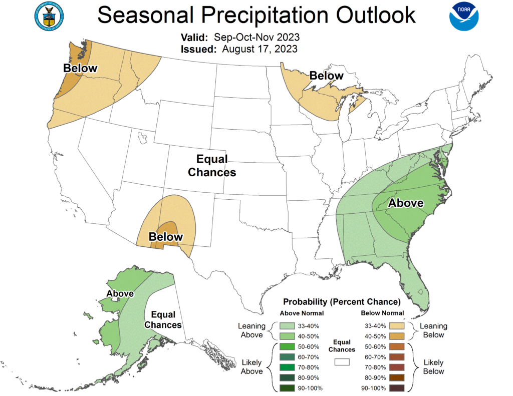
The Southeast has been dry instead of wet, so far. Baring a wet second half of November, drought will be expanding rather than contracting across the area. Why? Strong weather systems in association with an active jet stream have not materialized, partially I think due to global warming. Going out in time we see a warm pattern with very few jet wiggles to work with from the Rockies eastward:

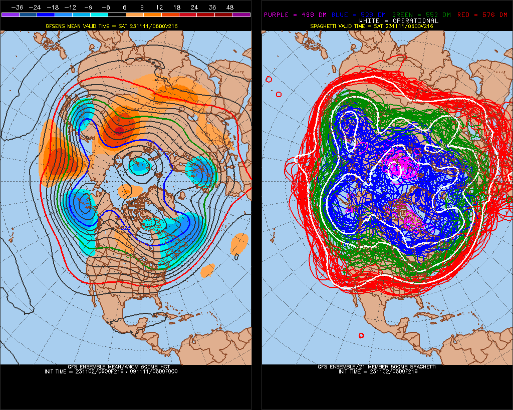
If the above operational model or associated ensembles verifies, we should see the start of a traditional split flow El Nino pattern, which will bring relatively dry weather to the northern tier of states and cool wet weather to the southern states after November 15th. But do expect to see an “unusual” event somewhere.
As warm as sea surface temperatures are across the globe, don’t be surprised if a wet seasonal forecast is a big bust:

I’ll let my readers know just exactly how odd weather gets across the country as we move from fall to winter this year.
Here are some “ET’s” recorded from around the planet the last couple of days, their consequences, and some extreme temperature outlooks, as well as any extreme precipitation reports:
The most extreme event in Chinese climatic history:
— Extreme Temperatures Around The World (@extremetemps) November 2, 2023
906 monthly records and 13 provincial records broken in just 2 days.
And this is just the beginning, the heat in the South will just get worse and dozens millions Chinese will need AC this November days. https://t.co/Gc14fX4k4y
James Hansen, @LeonSimons8 et al released their peer-reviewed “Global Warming in the Pipeline” paper! Here are some key points: 1/9https://t.co/TpYIamnWrO
— Dan Miller (@danmiller999) November 2, 2023
[1]
— Extreme Temperatures Around The World (@extremetemps) November 2, 2023
INCREDIBLE HEAT IN THE KOREAS
Records were brutalized with huge margins allover both countries.
29.1 Gangneung destroys the November South Korean record
28.5 Ulchin
28.3 Suncheon
28.0 Pohang
27.7 Bukgangneung
27.6 Ulsan
27.5 Sokcho and Sangju
…..25.9 SEOUL pic.twitter.com/tKWbnucNv7
UNBELIEVABLE 27.3C at Nampo in NORTH KOREA
— Extreme Temperatures Around The World (@extremetemps) November 2, 2023
National record pulverized.
Most extreme event in Korean climatic history.
Also ridiculous 26.0C in the capital Pyongyang, 26.5 Yangdok, 26.0 Sariwon, 25.3 Ryongyon ,24.9 Kaesong,
records destroyed with insane margins allover the country pic.twitter.com/KjLywtPs81
HISTORIC HEAT IN JAPAN
— Extreme Temperatures Around The World (@extremetemps) November 2, 2023
One of the most extreme events in Japanese history with insane temperatures close to 30C during the night !
29.7C at Ekawasaki ,122 records fell today but hundreds more are expected next days, the worst has yet to come.
Summer days in November… https://t.co/JxphYLvtgL
Overwhelmed by heat records in Asia,Europe and Africa ?
— Extreme Temperatures Around The World (@extremetemps) November 1, 2023
In the AMERICAS there is some competition
Record heat in the Caribbeans (next tweet ) and
Cold spells in North America and ARGENTINA
November cold records
-2.0C Viedma
0.7C Benito Juarez
Futher North,Brazil is sizzling. https://t.co/UHMF1aqlP0
Exceptional cold spell in #Argentina, several November records of lowest max. fell:
— Extreme Temperatures Around The World (@extremetemps) November 2, 2023
Ceres 14.0C
Sauce Viejo 14.2C
Corodba Aero 10.7C
Pilar Obs 11.4C tied
Marcos Juárez 12.8C
Paraná 13.5C
Gualeguaychu 13.8C https://t.co/oCort7xNGG
Record heat also in Turkey:
— Extreme Temperatures Around The World (@extremetemps) November 1, 2023
31.7 Osmanye
31.7 Silifke
31.5 Alanya
32.5 Kozan
etc…
The weekend will see an insane heat wave with sirocco and fohn and more records from West to East from North to South. https://t.co/0N4s4C9Zqg
Record heat in Tobago (Trinidad and Tobago, Southern caribbeans):
— Extreme Temperatures Around The World (@extremetemps) November 1, 2023
33.4C today at Tobago Airport breaks the November record.
Tobago has been with relentless record heat /day and night for weeks.
It's even hotter than the bigger Trinidad Island these days. pic.twitter.com/PINERYYga7
DUBAI protests why didn't I mention its record:
— Extreme Temperatures Around The World (@extremetemps) November 1, 2023
Here you have:
38.1C Dubai AP HOTTEST NOVEMBER DAY ON RECORDS.
Dozens millions km2 of near continuum record heat , dozens countries,thousands of records from Japan to Senegal; the world has never seen anything like or close to this https://t.co/tEvATB54Ql
Here is some more new October 2023 climatology:
October 2023 in #Denmark was the wettest October and wettest month overall in the last 25 years and the 9th wettest month in Danish climatic history with 148.1 mm nationwide
— Extreme Temperatures Around The World (@extremetemps) November 2, 2023
Average temperature was 10.0C which is 0.6C above normal and very few frost days
30% less sun than usual https://t.co/9tuJqjIvVv
October 2023 wasn't warm allover Europe:
— Extreme Temperatures Around The World (@extremetemps) November 2, 2023
Norway,Sweden and Finland were much colder than average . 1.7C below average in Norway and even something lower in Sweden and Finland, the two most below average countries in the world.
Locally in the North it was the coldest since 1992. pic.twitter.com/IdQPxntZ72
October 2023 in #Germany had an average temperature of 11.83C which is +2.34C above normal and was the 5th warmest on records (2022,2001,2006,2014, almost tied 1995).
— Extreme Temperatures Around The World (@extremetemps) November 2, 2023
Average precipitation was 170.1% of normal;specially wet in the North.
See maps by Bern Hussing. pic.twitter.com/tlxt9580nO
October 2023 in #Canada was warm:the warmest on record in parts of Quebec and Labrador. The Prairies had very warm anomalies in the first three weeks, but a strong Arctic blast in the last week brought the average back to near-normal. https://t.co/eDpIEzUpAJ
— Extreme Temperatures Around The World (@extremetemps) November 2, 2023
From Rick Thoman from Fairbanks
— Extreme Temperatures Around The World (@extremetemps) November 2, 2023
October 2023 in Alaska temperature anomalies were above normal in the north and Southeast and the southern Bering Sea
Utqiaġvik had the 4th warmest October on record and Cold Bay 5th warmest
Sitka had the 6th month in a row well warmer than normal pic.twitter.com/9DYGWve5Wo
Here is More Climate and Weather News from Thursday:
(As usual, this will be a fluid post in which more information gets added during the day as it crosses my radar, crediting all who have put it on-line. Items will be archived on this site for posterity. In most instances click on the pictures of each tweet to see each article. The most noteworthy items will be listed first.)
Long awaited paper by Hansen is out. No doubt many people will be sceptical… "…best estimate for doubled CO2 is global warming of 4.8°C, significantly larger than the 3°C best estimate of the United Nations Intergovernmental Panel on Climate Change." https://t.co/BcFIvlvJaf
— Alexander Ač 🇵🇸 (@Lacertko) November 2, 2023
Much awaited James Hansen paper is out. If correct, theoretical 2X CO2 yields warming on the very high end of model estimates: “Improved knowledge of glacial-to-interglacial global temperature change yields equilibrium climate sensitivity of 4.8°C ± 1.2°C https://t.co/019TTiu5Fv
— Jeff Berardelli (@WeatherProf) November 2, 2023
Jim Hansen et al's trailblazing climate paper here. Deep, technical, but a brilliantly accessible read.
— Prof Nick Cowern (@NickCowern) November 2, 2023
This is our future – we should get to know, respect, and honestly deal with it. No more rose tinted spectacles. @UKLabour @GreenLibDems @GreenJennyJones https://t.co/I4rVG6cvts
I Chat on James Hansen’s Vitally Important new landmark paper: Global Warming in the Pipeline
— Paul Beckwith (@PaulHBeckwith) November 3, 2023
Climate sensitivity for 2xCO2: 3.6C to 6.0C; midpoint 4.8C
Warming: 0.27 C per decade
Faustian Bargain Reckoninghttps://t.co/HlJWfQxoBs#ClimateAction #ClimateCrisis #climate pic.twitter.com/UU30316PJd
Stunning quote from a scientist. We need this now and forever. This honesty – because it is the truth and until that changes nothing will.
— Sophie Gabrielle (@CodeRedEarth) November 2, 2023
"one dollar/one vote."
We live in corporate oligarchies . This is not democracy as they sacrifice humanity for profit.#ClimateEmergency pic.twitter.com/4bbC6VosIA
"It has always been risky to ignore [James Hansen's] warnings and admonitions…So it with no pleasure whatsoever that I find myself in a position to have to criticize his latest work."
— Prof Michael E. Mann (@MichaelEMann) November 2, 2023
My commentary on Hansen's new article: https://t.co/LnETNeLV2y
"Global heating is accelerating, warns scientist who sounded climate alarm in the 80s" [w/ some skeptical comments from yours truly] by @olliemilman for The @Guardian: https://t.co/Xnm25MLUNt
— Prof Michael E. Mann (@MichaelEMann) November 2, 2023
The claim by Hansen et al today that climate sensitivity is 4.8°C ± 1.2°C per doubling CO2 is just as plausible as the claim by Cropper et al four days ago that its 2.8°C ± 0.8°C.
— Zeke Hausfather (@hausfath) November 2, 2023
Across hundreds of different studies, and our best estimate remains somewhere between 2C and 5C. pic.twitter.com/nRKILZ0lB3
"New study warns climate is warming even faster than some think" by @afreedma for @axios https://t.co/BPhCRPcwwC
— Prof Michael E. Mann (@MichaelEMann) November 2, 2023
Recap of remarkable #StormCiaran:
— Capital Weather Gang (@capitalweather) November 2, 2023
* Record winds in NW France with gusts 90-120 mph; over 1M people lost power; trees toppled, buildings damaged
* Record for lowest Nov pressure set in S England
* Offshore waves up to 70 ft
Detailed recap: https://t.co/0N9foLBTVx
Pictured: Gusts! pic.twitter.com/m2WyaMyOxx
Storm Ciarán lashes Western Europe and the UK with dangerously strong winds, heavy rain, and even hail. pic.twitter.com/BLPGbwQYKt
— CIRA (@CIRA_CSU) November 2, 2023
One of my first tweets years ago, was to say that Earth is much more sensitive to warming than anyone realizes
— GO GREEN (@ECOWARRIORSS) November 2, 2023
Now even main stream scientists get it
"The Earth’s climate is more sensitive to human-caused changes than scientists have realized until now"https://t.co/vaESZ8Kjhy
It's been common knowledge for at least 5 years among everyone who knows anything about climate change that warming threatened to be faster than expected with 1.5°C in the 2020s, 2°C soon after, and 3°C possible by 2048- 2052. Mass media stayed silent. 🧵https://t.co/50atOVlhBT
— Ben See (@ClimateBen) November 2, 2023
more and more scientists think climate change is an emergency. I explain why I agree on The Climate Brinkhttps://t.co/0Aq3Nrlx0E
— Andrew Dessler (@AndrewDessler) November 2, 2023
The UK and Ireland dodged a bullet with #Stormciaran Yes there was plenty of damage and some flooding etc but this is only a precursor to much bigger storms to come as industrial civilization continues to heat the globe rapidly to levels never experienced for millions of years. pic.twitter.com/1XaD3TJlux
— Peter Dynes (@PGDynes) November 2, 2023
From our archives: Nature-based climate solutions are cheap, effective — and grossly underfunded, Fred Pearce writes.https://t.co/ECGXv4tvm9
— Yale Environment 360 (@YaleE360) November 2, 2023
Most of the #Antarctic sea-ice edge was smaller than average in October 2023, except for the Amundsen-Bellingshausen Seas and parts of the Pacific Ocean sector.
— Zack Labe (@ZLabe) November 2, 2023
Data from https://t.co/ydZwSgdnwa. Concentration = fraction of sea ice in a location. pic.twitter.com/sYV5uh8Cgh
Watch it. https://t.co/JI9YS7TEtA
— Prof. Stefan Rahmstorf 🌏 🦣 (@rahmstorf) November 2, 2023
The scale of the fires currently burning across northern Australia is pretty unfathomable.
— Dr Robbi Bishop-Taylor 🛰️🌎🌊 (@SatelliteSci) November 3, 2023
This animation visualises just the last two months of fire captured by #DEAHotspots – for context, the map covers an area larger than France, Spain and Germany combined… pic.twitter.com/YBkOQP5xCK
The entire continent of Africa is responsible for less than 4% of historic global emissions, yet African people are bearing the brunt of the climate crisis. We are experiencing profound damage to our societies, our economies and most importantly our people.https://t.co/hSru8faORa
— Vanessa Nakate (@vanessa_vash) November 3, 2023
Invest 97L is yet another classic example of the GFS/GEFS false alarm bias for western Caribbean tropical cyclones — both lacked much support among other models, and while heavy rains are still expected in Central America, a tropical cyclone is unlikely to form. pic.twitter.com/Vo37Hljp5d
— Tomer Burg (@burgwx) November 2, 2023
Extremely happy that my new paper on the future of Antarctic surface melting is finally published!🎉
— Julius Garbe (@juliusgarbe) November 2, 2023
We use a new melt module in the @PISM_model, which in addition to temperature also takes into account the effect of solar radiation & thus the melt–albedo feedback. Check it out! https://t.co/STFtSUaoxp pic.twitter.com/ZyqEmwAxQA
Five books you might like to read when asking what you can do about the #ClimateEmergency🧵
— Dr. Aaron Thierry (@ThierryAaron) June 18, 2023
1. @ClimatePsych's excellent guide for turning anxiety into action pic.twitter.com/fJxyGb9orq
Today’s News on Sustainable, Traditional Polluting Energy from Fossil Fuel, and the Green Revolution:
“If successful, Toyota expects its electric cars powered by solid-state batteries to have a range of 1,200km (750 miles) — more than twice the range of its current EVs — and a charging time of 10 minutes or less.”
— Jeff Berardelli (@WeatherProf) November 2, 2023
https://t.co/MUg8SYmm8N
Encouraging and well-reported piece from @Sammy_Roth on the strength of the YIMBY movement in California. People want solar panels and wind turbines nearbyhttps://t.co/AsvDXDhAGC
— Bill McKibben (@billmckibben) November 2, 2023
A very smart take from @KateAronoff on the geopolitics that will have to be overcome if we're going to deal with the massive LNG export climate debacle.
— Bill McKibben (@billmckibben) November 3, 2023
I think Biden will do the right thing–but it won't be easyhttps://t.co/rKdPle98L0
Almost 50% renewables in Dutch electricity now!
— Kees van der Leun (@Sustainable2050) November 3, 2023
48% of national demand for the running 12-month average; 53% in October. https://t.co/eeLZuZ22En
Graph of the Week: Clean Energy Makes Germany's Grid More Reliable https://t.co/BUljeoFkA4 pic.twitter.com/KUuUW8fxrw
— Peter Sinclair (@PeterWSinclair) November 2, 2023
More from the Weather Department:
#ClimateFriday Reading: #ExtremeWeather – "Rain is expected to fall all over the country throughout the rest of the week…" Traveling? Northern Italy hit with massive rainstorms and subsequent flooding:https://t.co/euGIxAS7jS
— Silicon Valley North (@CCLSVN) November 3, 2023
1.2 million homes in France are without power, as windows are blown out and schools closed by Storm #Ciaran.https://t.co/15EM1IEiVJ
— Extinction Rebellion Global (@ExtinctionR) November 2, 2023
The UK and Ireland dodged a bullet with #Stormciaran Yes there was plenty of damage and some flooding etc but this is only a precursor to much bigger storms to come as industrial civilization continues to heat the globe rapidly to levels never experienced for millions of years. pic.twitter.com/1XaD3TJlux
— Peter Dynes (@PGDynes) November 2, 2023
New study says human-caused climate change is increasing the coverage and intensity of violent thunderstorm winds during the summer, like we saw during the 2020 derecho in Iowa.
— Capital Weather Gang (@capitalweather) November 2, 2023
Link to our write-up of this study: https://t.co/tRnXbptFTH pic.twitter.com/46Jp1uWZLb
Interesting to see some EC46 members with a U10/60 reversal (sudden stratospheric warming) in early December. This would be a rare event for the time of year – last occurring in 1998.
— World Climate Service (@WorldClimateSvc) November 2, 2023
October's Météo-France seasonal model hinted at this, and interestingly skill is rather good. pic.twitter.com/W9aGvyjcuu
Darkness continues to advance southward. Winter is coming!
— Zack Labe (@ZLabe) November 2, 2023
[Satellite imagery from @NASAEarthData at https://t.co/BZHUWJExsm] pic.twitter.com/HRDI9ABSDp
#HurricaneOtis was the strongest Eastern Pacific #hurricane to make landfall in the satellite era, and @NOAA satellites were watching
— NOAA Satellites (@NOAASatellites) November 2, 2023
Learn more about #Otis in the latest #EarthFromOrbit video: https://t.co/wWBMCrA2rL pic.twitter.com/yrmemdVt6v
⚠️ #StormCiarán has set a new record for the lowest mean sea level pressure recorded in England and Wales in November, with a value of 953.3 hPa (mb) in Plymouth and 958.5 hPa (mb) in St Athan
— Met Office (@metoffice) November 2, 2023
◾ The previous record in England was 959.7 hPa (mb), set in 1916
◾ The previous… pic.twitter.com/zruckdYR2K
Updated 2023 Hurricane Season map with all 20 storms so far. Will we see Vince? https://t.co/Hk3pbO7x8H pic.twitter.com/XhIKKjqfSa
— Mike's Weather Page (@tropicalupdate) November 2, 2023
More on the Environment and Nature:
They kill babies don"t they?
— GO GREEN (@ECOWARRIORSS) November 2, 2023
No its not an Israeli bomb
but the humble Pine Martin
No larger than a cat and almost extinct
and now making a comeback in Ireland
but farmers stoking up fear and hatred demanding a cull ridiculously claiming they could kill a baby
They never have https://t.co/gleTVEbN9O pic.twitter.com/zT0f74geJb
In Alaska, tundra burned by wildfire is emitting more methane than the rest of the landscape, even after the fire is out. Methane can come from thawed permafrost and its release could accelerate climate change and lead to more frequent wildfires in the tundra. pic.twitter.com/lf5esEn8X7
— NASA Earth (@NASAEarth) November 2, 2023
From our archives: Siddharth Kara explores the steep human cost of cobalt mining in the Congo.
— Yale Environment 360 (@YaleE360) November 3, 2023
“We’re talking about hundreds of thousands of people involved in this, including tens of thousands of children as young as five.”https://t.co/ep5Dh9dOIr
A bumblebee can only fly for about 40 minutes between feeding. But we've lost 97% of our wiłdflower meadows. So each nectar-rich flower you plant in a windowbox or your garden or community green spaces could be the pit stop that saves a bee 🐝
— UN Biodiversity (@UNBiodiversity) November 3, 2023
Via @LGSpace pic.twitter.com/iegKDdeo86
More on Other Science and the Beauty of Earth and this Universe:
With heavy hearts, we bid farewell to @USNavy rear admiral and @NASA astronaut Ken Mattingly. His brave contributions providing critical decisions to rescue the Apollo 13 crew, and serving as a key player in the Apollo and early Shuttle programs will long be remembered. #RIP 🫡 pic.twitter.com/RRMfQjuxGz
— NASA History Office (@NASAhistory) November 2, 2023
Sunrise at Stonehenge today (2nd November) was at 7.00am, sunset is at 4.39pm 🌧💨 #StormCiaran pic.twitter.com/VnOrQr0tlY
— Stonehenge U.K (@ST0NEHENGE) November 2, 2023
Night thoughts
— Green is a mission (@Greenisamissio1) November 2, 2023
You don't always have to clear everything away immediately. Nobody does it in the forest and it works wonderfully.💚🌱☘️🌿🌳🌲🍀💚 pic.twitter.com/pFw3RvpSKa
The sound of bubbling and splashing water, the elixir of life, the cooling effect impressively reflects the power of nature. This makes it all the more important to protect it every day and to preserve the purification of water through forests and plants. No water, no life.💚🌳🌲 pic.twitter.com/tYLPR51XzT
— Green is a mission (@Greenisamissio1) November 2, 2023