The main purpose of this ongoing blog will be to track global extreme or record temperatures related to climate change. Any reports I see of ETs will be listed below the main topic of the day. I’ll refer to extreme or record temperatures as ETs (not extraterrestrials).😉
Main Topic: A Warmer Environment Will Add to Atmospheric River Deluges
Dear Diary. My readers know by now that climate change is making precipitation events heavier because it is warming both the atmosphere and oceans. A warming environment ramps up the water cycle into higher gears. If you have been glancing at Twitter or X notes recently from meteorologists, you know that another very potent atmospheric river is poised to soak California this weekend. Rainfall totals will be particularly heavy in Southern California where the National Weather Service has been issuing advisory statements due to more than eight inches expected in spots.
I have no doubt that this event will be enhanced by climate change. I’ll leave it up to attribution scientists to roughly tell how much more precipitation fell from this event compared with similar El Nino related systems from the past.
Jeff Berardelli has a video linked to Twitter explaining why this weekend atmospheric will be enhanced by a warming environment which I am sharing today:
Berardelli Bonus: CA is about to be hit by another dangerous atmospheric river. 6-12” of rain in the hills along the central-south coast, nearby cities, means flash floods! Atmospheric rivers are getting wetter due to warming, 15% so far, and another ~25% projected in future. pic.twitter.com/cwPf4Rons1
— Jeff Berardelli (@WeatherProf) February 3, 2024
Ocean warmth will be contributing to the weekend event:
This warm ocean increases amount of moisture in lower levels of atmosphere (& thus in storms) due to increased evaporation, and may also be contributing to apparent propensity for extreme hourly t-storm downpours this year in coastal CA by boosting convective instability. [2/2]
— Dr. Daniel Swain (@Weather_West) February 1, 2024
Here are more details about this weekend’s flooding event for Southern California:
Severe California storm could unleash life-threatening flooding – The Washington Post
Dangerous California storm could trigger life-threatening flooding, forecasters warn
An atmospheric river is predicted to unleash excessive rainfall, damaging winds and massive waves late Saturday through Monday
By Dan Stillman, Diana Leonard and Ian Livingston
Updated February 3, 2024 at 9:06 a.m. EST|Published February 2, 2024 at 1:31 p.m. EST
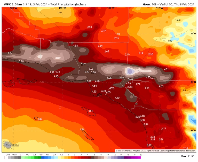
Precipitation forecast for the Los Angeles region through Wednesday. (weatherbell.com)
Forecasters at the National Weather Service are warning of a “significant threat of widespread and very dangerous flash flooding” Saturday night through Tuesday for much of densely populated Southern California. The cause is a particularly intense atmospheric river that will aim a fire hose of moisture at the coast and run up against the region’s mountainous terrain.
The potential for flooding is highest from around Santa Barbara to the south, although flood watches have been hoisted from San Francisco and the northern Central Valley to the border with Mexico. Strong winds, mountain snow and dangerously high surf are also a concern.
The Weather Service office serving the Los Angeles region is cautioning that the expected torrents could trigger rock and mudslides in the mountains, and flooding of small streams, rivers and roadways throughout the region. Burn scars left behind by wildfires will be particularly prone to flooding and debris flows.
Evacuation orders have already been issued for burn scar areas and some properties in Montecito in Santa Barbara County.
Floodwaters submerged residential areas of Los Angeles County on Feb. 1 as an atmospheric river brought heavy rain to the area. (Video: The Washington Post)
“Flooding issues will not be confined to just the foothills, mountains, and burn areas,” the Weather Service wrote in a discussion Saturday. “ALL AREAS, INCLUDING HIGHLY POPULATED URBAN AREAS, WILL BE AT RISK FOR LIFE-THREATENING FLOODING. Streams and small rivers, as well as the Los Angeles River through the San Fernando Valley and metro LA will rise quickly and turn into very dangerous raging rivers. Many roads will be impassable due to flooding.”
The renewed potential for flooding comes just days after another atmospheric river dumped several inches of rain across portions of the state, including record daily amounts in Southwest California.
Many foothill and mountain areas could see 6 to 12 inches of rain. Santa Barbara, a coastal city with steep mountains behind it, could be particularly vulnerable. Such amounts have caused “major” problems in the past, the Weather Service said.
“Between the tremendous amount of moisture that this storm has with it, good southerly flow and slow movement — those are all the ingredients for some of our biggest storms,” said David Bruno, a meteorologist with the Weather Service in Oxnard, Calif. “But I want to stop short of saying that this is going to be something we’ve never seen before.”
Downtown Los Angeles is expected to pick up 4 to 5 inches of rain, which wouldn’t be unprecedented for a two-day period. “However, if we start talking 6 or 7 inches of rain in two days, then we’re close to the top few events ever,” Bruno said.
The Center for Western Weather and Water Extremes, based in La Jolla, Calif., predicts that the atmospheric river will reach Category 3 on its one-to-five scale, with Category 5 being the most extreme. The scale defines a Category 3 atmospheric river as “strong” and producing a “balance of beneficial and hazardous impacts,” including the threat of flooding but also helping to refill reservoirs. A Category 3 is considered by meteorologists to be on the higher end of atmospheric rivers that have hit Southern California.
The Weather Service also placed portions of Central and Southern California under an unusual (for the region) Level 3 of 4 risk for excessive rainfall both Sunday and Monday.
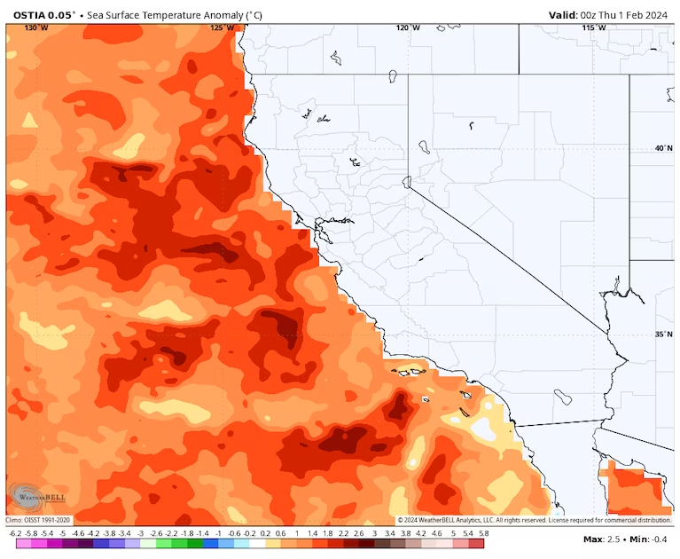
A map shows sea surface temperature off California as much as 3.5 to 4.5 degrees Fahrenheit above normal. (WeatherBell)
Downpours will be fueled by unusually warm waters off the California coast, intensified by the El Niño climate pattern. Sea surface temperatures are much as 3 to 4 degrees Fahrenheit above normal.
“This warm ocean increases amount of moisture in lower levels of atmosphere (& thus in storms) due to increased evaporation, and may also be contributing to apparent propensity for extreme hourly t-storm downpours this year,” Daniel Swain, a climate scientist at the University of California at Los Angeles, wrote on X, formerly Twitter.
The forecast for Southern California
Rain chances increase late Saturday afternoon and into the night, first in Central and then in Southern California. The heaviest rain and highest risk for widespread flooding of roads, streams and rivers is anticipated Sunday through Sunday night in Santa Barbara, Ventura and San Luis Obispo counties, and Sunday night into Monday in Los Angeles County.
Strong and damaging winds, gusting from 40 to 60 mph from the southeast, could also cause power outages, while travel delays and road closures are likely because of heavy mountain snow and the threat of mudslides.
Particularly heavy rain is likely on and below the south side of mountain ranges such as the Santa Ynez and Topatopa ranges. Rainfall rates of a half-inch per hour could last for many hours with up to one inch per hour possible on and below south-facing slopes. There’s also a slight chance for thunderstorms in San Luis Obispo and Santa Barbara counties.
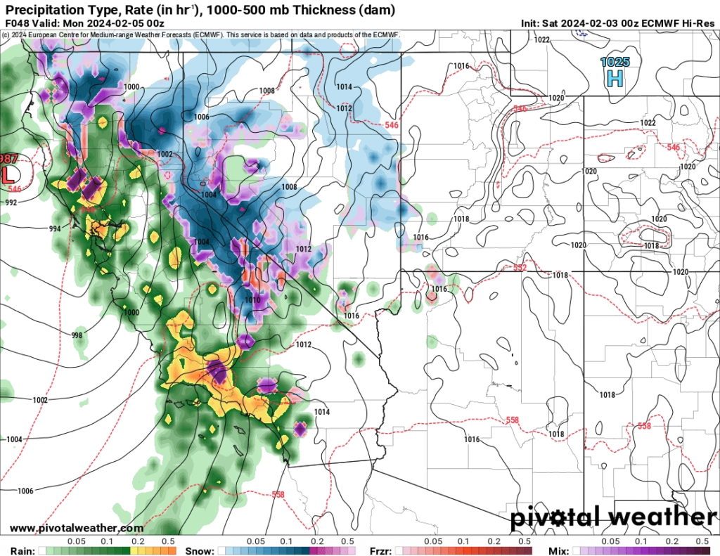
Heavy rain and snow forecast for Sunday night. (Pivotal Weather)
The exact timing of the heaviest rain in Los Angeles County, how long it will last and ultimately how much will fall are uncertain because models indicate the storm’s plume of moisture could temporarily stall over Santa Barbara and Ventura counties during Sunday into the night. The heaviest rain is also forecast to begin to wane as it passes Los Angeles and heads farther southward.
The Weather Service is predicting an average of 3 to 6 inches in most coastal and valley areas through Monday and up to 6 to 12 inches in the foothills and mountains; the highest totals are projectedacross the mountains of southern Santa Barbara and western Ventura counties. Southern Santa Barbara County through western Los Angeles County has the best chance of seeing rainfall totals reaching the upper end of the forecast ranges, especially if the moisture plume slows or stalls there.
The rainfall will come after records were set Thursday at several locations in southwest California, including 2.93 inches at Santa Barbara, 2.49 inches at Los Angeles and 2.45 inches at Long Beach.
Farther south, Orange and southwestern San Bernardino counties are expecting 3 to 4 inches in coastal areas and 5 to 8 inches in the mountains, with locally greater amounts. For San Diego and western Riverside counties, which experienced serious flooding about 10 days ago, additional rainfall of 2 to 3 inches is possible near the coast and perhaps 3 to 5 inches in the mountains and 0.5 to 1 inch in the eastern deserts.
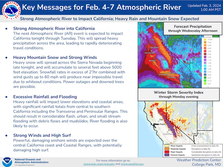
Key messages from the Weather Prediction Center
The storm will also lash the region with strong winds, moderate coastal flooding and dangerous surf plus rip currents. Winds along the coast could reach or surpass 50 mph Sunday and Monday. Dangerous seas are forecast to reach 8 to 12 feet south of Point Conception, the Weather Service said, with harbor areas of Port San Luis and Morro Bay at risk for damaging conditions. In the mountains, winds could top 70 mph.
The forecast for the Bay Area and Central Coast
Flood watches are up for the Bay Area and Central Coast late Saturday afternoon into Monday morning after many locations recorded 4 to 5 inches of rain Wednesday into early Thursday. The Weather Service is warning of flooding on creeks, streams and rivers, and in urban and low-lying areas.
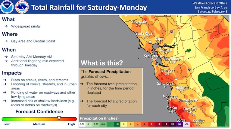
Predicted rainfall through early Monday morning in Bay Area and Central Coast. (NWS)
Rain should arrive Saturday evening along the Big Sur coast before spreading north and east through Saturday night. The heaviest rain arrives early Sunday with highest amounts through Monday expected along the Central Coast at Big Sur and the Santa Lucias, where rainfall could reach 5 to 7 inches. Lesser amounts around 2 to 3 inches are forecast around San Francisco and Oakland.
A high-wind warning has been issued for Sunday for the San Francisco Peninsula Coast and coastal zones and high elevations just to the north;the Santa Cruz Mountains; Eastern Santa Clara Hills; East Bay Hills; and Northern Monterey Bay because of the potential for gusts up to 60 mph that could blow down trees and power lines. In some areas, especially southern zones, the winds could be stronger than the previous storm.
Heavy mountain snow could fend off drought threat

Snowfall forecast from the Weather Prediction Center. (FTWP)
While most storms this winter have targeted coastal California, the upcoming atmospheric river could also deliver a widespread 2 to 5 feet of snow above 5,000 feet in in the Sierra Nevada, and higher totals likely at the highest elevations.
“Snowfall rates in excess of 2”/hour combined with wind gusts up to 60 mph will produce near impossible travel due to whiteout conditions,” the Weather Service warned.
This is a welcome change given that precipitation has been lagging behind in this key region for the California’s water supply. Statewide snowpack is only about half of where it should be this time of year, though it has improved this week.
Because of the deficits, the latest federal Drought Monitor placed a swath of the Sierra Nevada in the “abnormally dry” category, which can be a precursor to drought.
However, California’s reservoirs are still above average and flush with water because of last year’s record-breaking snowy winter. In fact, some reservoirs are releasing water for flood protection ahead of this week’s storms.
“Even though this winter has provided below average precipitation overall, it can only take one storm to produce severe flooding in the right circumstances,” the California Department of Water Resources said in a statement this week. “Communities in San Diego, the Bay Area and along the North Coast have already experienced flooding impacts this winter, highlighting the need to always be prepared for flood risk.”
Jason Samenow contributed to this report.

By Dan Stillman Dan Stillman is a meteorologist and editor for the Capital Weather Gang. He earned an M.S. in Meteorology from Texas A&M University, and a B.S. in Atmospheric, Oceanic and Space Sciences from the University of Michigan. Twitter
By Diana Leonard Diana Leonard is a San Diego-based science journalist covering weather and climate in California and the West, and has frequently written about wildfire and other hazards for The Washington Post. A Pittsburgh native but a longtime California resident, she holds MA and PhD degrees in Geography from the University of California at Berkeley.

By Ian Livingston Ian Livingston is a forecaster/photographer and information lead for the Capital Weather Gang. By day, Ian is a defense and national security researcher at a D.C. think tank. Twitter
More on this weekend’s California storm:
Here are more “ET’s” recorded from around the planet the last couple of days, their consequences, and some extreme temperature outlooks, as well as any extreme precipitation reports:
SOUTH AMERICA HISTORIC HEAT WAVE
— Extreme Temperatures Around The World (@extremetemps) February 3, 2024
Climatic history is being rewritten with the insanity happening:records are falling from Guyana (34.2C St Laurent) all the way to Argentina
CHILE:Crazy 42.2 at Llay Llay (Valparaiso),40.4 Limache,40.2 Olmue, hottest day in their climatic history. pic.twitter.com/x88qiyzWEC
Extraordinary warm spell in EUROPE
— Extreme Temperatures Around The World (@extremetemps) February 3, 2024
After a record warm night with Tmins locally >+10C/12C in Central Europe,max. temperatures reached
25.6C at Ceret in FRANCE
22.4C at Acquarossa SWITZERLAND
Next days it will be even warmer and some records will fall first in the West than East pic.twitter.com/rTXklW2UUG
Here is more brand-new January 2024 climatology:
January 2024 temperatures in Alaska were above normal on the North Slope and most of western Alaska, below normal over the Interior and Southcentral and generally close to normal in Southeast.
— Extreme Temperatures Around The World (@extremetemps) February 3, 2024
See temperature anomalies
Text and Map Credit:Rick Thoman. pic.twitter.com/adGKdWGtsE
January 2024 in IRELAND . https://t.co/0K8lHgAHA3
— Extreme Temperatures Around The World (@extremetemps) February 3, 2024
January 2024 in #Denmark had an average temperature of +1.0C which is 0.6C below normal.
— Extreme Temperatures Around The World (@extremetemps) February 3, 2024
It was warmer than normal near the German border and colder in the North.
It was another wet month: 30% wetter than average.
Map by DMI. pic.twitter.com/IemSo1RuFJ
January 2024 in #Poland had a temperature anomaly of +0.92 above the 1991-2020 norm.
— Extreme Temperatures Around The World (@extremetemps) February 3, 2024
It ranged from -0.25C in the Northwest-the only colder than average area- to +1.57C in the Southwest.
Map by Meteomodel. pic.twitter.com/hHBEyIe4QE
Here is More Climate News from Saturday:
(As usual, this will be a fluid post in which more information gets added during the day as it crosses my radar, crediting all who have put it on-line. Items will be archived on this site for posterity. In most instances click on the pictures of each tweet to see each article. The most noteworthy items will be listed first.)