The main purpose of this ongoing blog will be to track planetary extreme, or record temperatures related to climate change. Any reports I see of ETs will be listed below the main topic of the day. I’ll refer to extreme or record temperatures as ETs (not extraterrestrials).😉
Main Topic: Climate Factors Leading to a Very Stormy Spring for the U.S.
Dear Diary. Practically every day in May I have added many weather reports of tornadoes and severe outlooks in my weather section, which is just below my climate news section. It grieves me to see reports of destruction and deaths, the latest being from Greenfield, Iowa, which was nearly totally obliterated by an EF4 tornado. We have brought this question up every spring. How much has climate change affected severe weather across the United States?
We are starting to get more answers to this important query. It appears that we are getting more outbreaks farther north during the cold season, which is logical because warner unstable airmasses are building further north during autumn and winter with time. During the spring there is has been a statistical shift towards the east from the Plains into the South and East. However, as far as the number of severe weather events or strength of tornadoes go, there has not been a clear change, so far.
We have recently seen large swings between very active seasons, such as that in 2011, and ones in which there is a dearth of strong tornadoes, like that of 2018. This has a lot to do with cold trough/ridge or heat dome configurations. With time during the spring, heat domes will build over the U.S. sooner during the spring, cutting down on the number and severity of severe outbreaks, but this trend has not started to take place so far in the 21st century.
My friend Bob Henson has written a long summary on this spring’s severe weather and delves more into our main topic in his latest Yale Climate Communications article:
Another tornado-devastated town: Why so much severe weather this spring? » Yale Climate Connections
Another tornado-devastated town: Why so much severe weather this spring?
It’s the nation’s worst storm season in a few years, though well short of record territory.

by BOB HENSON
MAY 23, 2024

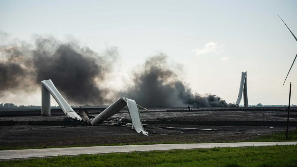
A utility-scale wind turbine was left in smoky ruins after a tornado strike in southwest Iowa on May 21, 2024. (Image credit: Charlie Randall)
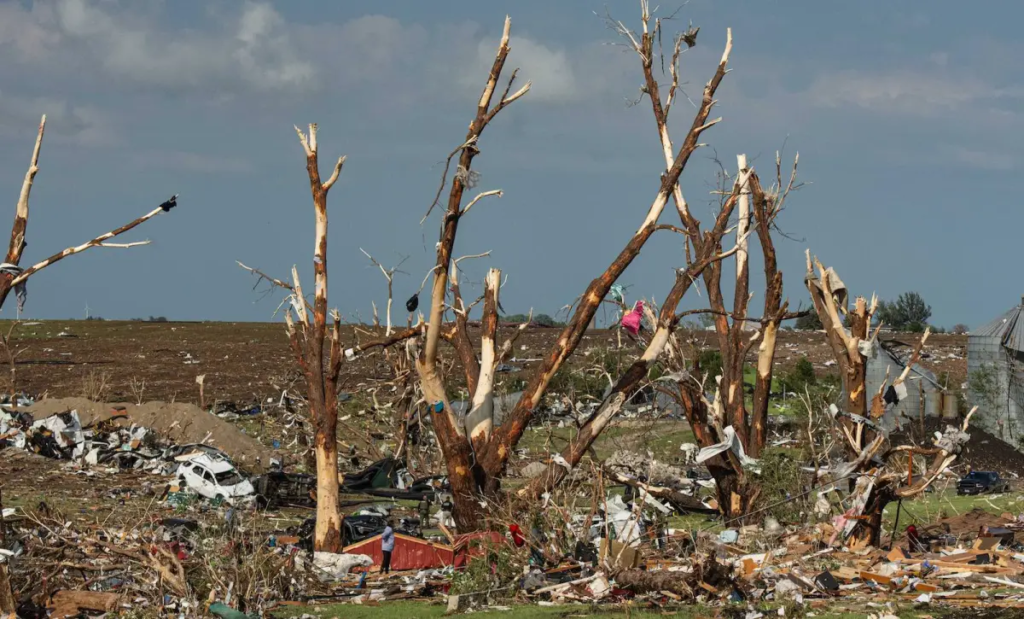
Greenfield, Iowa, is the latest town added to this year’s poignant U.S. list of tornado-shattered communities. A powerful twister raced through Greenfield on Tuesday, May 21, taking at least five lives and leaving a narrow swath of major destruction across the southwest Iowa town of about 1,000.
Four people died in Greenfield, according to an Associated Press report that cited the Iowa Department of Public Safety, and a motorist was killed north of the town of Corning.
The Greenfield tornado was given an initial rating late Wednesday of at least EF3 on the Enhanced Fujita Scale, based on damage surveys organized by the National Weather Service office in Des Moines. The rating is subject to revision as surveying continues.
Tornadic winds are typically stronger just above ground level, as observed by the Doppler on Wheels portable radar (see embedded tweet below).
The Greenfield twister was the worst among a crop of at least 27 tornadoes on Tuesday that stretched from Oklahoma to Wisconsin, based on preliminary reports compiled by the NOAA/NWS Storm Prediction Center (SPC).

Figure 1. A scene from the corridor of destruction left by a tornado in Greenfield, Iowa, on May 21, 2024. (Image credit: Charlie Randall)
For the month to date through May 22, SPC had gathered 325 preliminary tornado reports (with duplicates filtered out) as of late Wednesday. This total includes 159 tornadoes from a brutal three-day stretch on May 6–8. The tally this month is already well above the full-May average of 276 tornadoes, based on 1991-2020 data, and among the highest in recent years. SPC’s year-to-date tornado count of 870 through May 22 is the highest for that period since 2017.
More severe weather is in the cards through Memorial Day weekend, as SPC warned on Wednesday of a “concerning” setup. A reloading atmospheric pattern could spawn the full range of severe-weather hazards — from hail to strong tornadoes to destructive straight-line winds – especially in and near Oklahoma on Saturday, into the mid-Mississippi and Ohio/Tennessee Valleys on Sunday, and perhaps extending eastward and/or southward from there by Monday.
Significant severe weather is possible in some areas even ahead of the main event, including eastern Nebraska on Thursday and northeast Texas on Friday.

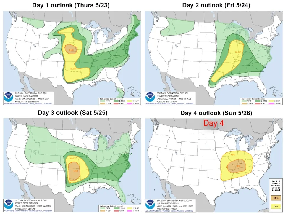
Figure 2. Severe weather outlooks issued Thursday morning, May 23, 2024, for Days 1 through 4 (May 23-26). The first three days of outlooks highlight areas of concern on a that includes “marginal” (1 on a 1-to-5 scale, shown in dark green), “slight” (2, yellow), “enhanced” (3, orange), “moderate” (4, red), and “high” (5, purple). The Day 4 outlooks include only two levels of expected severe weather coverage. Regular updates can be found on the Storm Prediction Center’s convective outlook page. (Image credit: NOAA/NWS/SPC)
What’s made this spring so stormy?
A resilient surface frontal zone lying between the Rockies and Appalachians has been oscillating north and south during much of May. Pockets of storm-triggering upper-level energy have been moving atop the wavy frontal zone, traversing a still-strong jet stream that hasn’t yet retreated north into its usual summer mode. It’s a classic mid-spring setup for a prolonged period of severe weather.
Such a pattern isn’t all that unusual for May, which is typically the peak month for U.S. severe weather. Just five years ago, May 2019 included a phenomenally stormy two weeks, from May 17 to 30, that generated 400 tornadoes, including 51 that were at least EF2 strength on the Enhanced Fujita Scale. That’s more than twice the number of EF2 to EF5 tornadoes confirmed so far this May.
Here are two examples of how wildly tornado activity can vary from year to year:
- In 2011, there was a horrific total of 1,706 tornadoes, the second-most on record behind 2004. This included 279 EF2-or-stronger tornadoes, including 17 violent EF4s and EF5s, and two days that each saw more than 150 people killed. The full-year toll of 553 deaths was the nation’s largest since 1925.
- In 2018, for the first time in reliable records dating back to 1950, there were no EF4 or EF5 U.S. tornadoes (although there were enough weaker twisters to yield a near-average tornado count). Only 10 tornado-related deaths were reported – the lowest in official and unofficial tallies that go back to the late 19th century.
Through May 21, this year’s tornadoes have taken at least 22 lives. All but a handful of the deaths were associated with manufactured homes or vehicles.
Apart from catastrophic one-off years such as 2011, U.S. tornado death tolls have steadily dropped in recent decades with the advent of enhanced communication tools, increased awareness, and warnings and outlooks that capture many events well in advance.
How is climate change affecting severe weather?
Not only are tornadoes naturally variable from day to day and from year to year, but twisters themselves are notoriously tough to quantify over time in a consistent way. For example, the advent of spotters and chasers led to a doubling of reported U.S. tornadoes from the 1950s to the 1990s but no change in the number of strong tornadoes. And while modern radar can now detect winds a few hundred feet above ground level in remarkable detail, it’s impossible to do apples-to-apples comparisons with tornadoes observed before the most sophisticated radars came on the scene this century.
All these factors make it hard for any tornado-related signal that might be related to climate change to rise above the level of natural variability. Moreover, the complex balance of factors needed to spawn a tornado isn’t boosted in a straightforward way by the increases in low-level heat and moisture that have long been linked more definitively to our warming climate.
Even so, researchers are starting to gaining ground on understanding potential changes in supercell thunderstorms, which are the ones most likely to spawn destructive tornadoes. A 2023 study – one of the first to conduct high-resolution simulations of supercells in future climates – found that the average area per year affected by strong supercell rotation (as measured by updraft helicity of more than 200 meters squared per second squared) could increase by late century by 26% in a medium-emissions scenario, and by 60% in a high-end scenario.
A signal already detected in a 2018 study, and projected to continue, is for tornado activity to increase in the vulnerable mid-Mississippi Valley and Southeast while decreasing somewhat in the “traditional” Tornado Alley of the Great Plains.
READ: Climate change and tornadoes: Any connection?
As for this month, the most unusual weather feature in play is the exceptional-for-May low-level heat and moisture that’s been feeding north at times into the atmospheric combat zone. The uncommonly sultry air mass is the product of an intense upper-level high stretching from Mexico across the Caribbean and southern Gulf, together with record-warm sea surface temperatures (see our May 22 post from Michael Lowry).
Several of the nation’s southernmost cities, including Brownsville, Texas, and Fort Myers, Key West, Miami, and Fort Lauderdale, Florida, have smashed records for their warmest May 1-20 period on record. Heat records have also melted across much of Mexico, Central America, and the Caribbean, as documented on Twitter/X by Maximiliano Herrera (@extremetemps)
There’s a well-established relationship between intense low-latitude upper highs and the destructive non-tornadic winds called derechos, as observed in Houston this month and in Iowa in 2020. So-called progressive derechoes often race from west to east along the northern fringe of such heat domes, where a strong jet stream and the sultry surface air are most likely to be juxtaposed.
There are hints that such derechoes might become a bigger concern in a warming climate, as heat waves intensify – though much like tornadoes, derechoes hinge on a complex set of interacting weather features that may not evolve in sync. One 2023 study that analyzed Iowa’s catastrophic derecho of August 2020 found that such an event might cover up to twice as much territory with damaging winds in a high-end emissions scenario.
Regardless of the subtleties in the relationship between our warming climate and severe weather, there’s nothing subtle about the financial havoc severe weather is wreaking on the nation. Among other factors, ever-larger homes and vehicles and ever-growing populations in hail-prone areas such as Dallas-Fort Worth and Denver are expanding the potential footprint for hail damage, the costliest component on average in severe weather disasters.
In a May 21 article for the Washington Post, Scott Dance broke down the non-meteorological elements that have greatly increased the number of billion-dollar thunderstorm-related disasters in recent years, including 19 last year alone.
A problematic portent for the summer ahead
In recent days, the subtropical heat and humidity have been extending northward to the central Gulf Coast states – including in storm-battered Houston, where tens of thousands of residents still lacked power on Wednesday almost a week after the city’s derecho.
The northward creep of record-level heat is more than a little disconcerting in light of summer outlooks from the National Weather Service, the Weather Channel, and other entities. There’s widespread agreement that above-average temperatures will progressively take hold across much of the country and intensify as the summer unfolds – a common outcome when a strong El Niño event shifts toward La Niña, as is happening now.
NOAA is predicting above-normal temperatures will swaddle the entire contiguous U.S. when averaged across the three-month period from July to September 2024. The Weather Channel envisions one of the hottest summers in U.S. history, while Climate Central notes that summers at 230 U.S. locations have warmed by an average of 2.5 degrees Fahrenheit since 1970.
Meanwhile, NOAA released its May 2024 hurricane outlook on Thursday, and it’s a doozy: 17 to 25 total named storms (winds of 39 mph or higher), including 8 to 13 hurricanes (winds of 74 mph or higher) and 4 to 7 major hurricanes (category 3, 4 or 5, with winds of 111 mph or higher). We’ll have more on the latest outlooks from NOAA and other entities in a future post.
Jeff Masters contributed to this post.
We help millions of people understand climate change and what to do about it. Help us reach even more people like you.
Bob Henson’s Another tornado-devastated town: Why so much severe weather this spring? was first published on Yale Climate Connections, a program of the Yale School of the Environment, available at: http://yaleclimateconnections.org. This work is licensed under a Creative Commons Attribution-Noncommercial-No Derivative Works 2.5 license (CC BY-NC-ND 2.5).

BOB HENSON
Bob Henson is a meteorologist and journalist based in Boulder, Colorado. He has written on weather and climate for the National Center for Atmospheric Research, Weather Underground, and many freelance… More by Bob Henson
Here are more “ETs” recorded from around the planet the last couple of days, their consequences, and some extreme temperature outlooks, as well as any extreme precipitation reports:
Here is some more April and May 2024 climatology (Prior reports are listed on older daily diary blogs for each calendar day.):
Here is More Climate News from Monday:
(As usual, this will be a fluid post in which more information gets added during the day as it crosses my radar, crediting all who have put it on-line. Items will be archived on this site for posterity. In most instances click on the pictures of each tweet to see each article. The most noteworthy items will be listed first.)