The main purpose of this ongoing blog will be to track planetary extreme, or record temperatures related to climate change. Any reports I see of ETs will be listed below the main topic of the day. I’ll refer to extreme or record temperatures as ETs (not extraterrestrials).😉
Main Topic: Midwest Flooding… Another Consequence of Heatwave Exxon
Dear Diary. What? You might be asking yourself how in the world can a major heatwave be part of historic flooding? My answer: Hot air holds more moisture that can be released as flooding rains, particularly where a moist, hot airmass interacts with the jet stream. This can happen in summer at the northern edge of heat domes. In the case of the dome from the heatwave that I’ve dubbed Exxon because of the fault from fossil fuel companies making the thing a monster, extreme climate changed heat has been a part of extreme Midwest flooding.
Here are more details from the Washington Post:
Midwest flooding intensifies as heat continues – The Washington Post
Minnesota’s Rapidan Dam at risk of failure as floods hit Midwest – The Washington Post
Minnesota’s Rapidan Dam at risk of failing as floods hit Midwest
The situation was the latest brought on by days of torrential rains last week, triggering flooding that had killed at least two people.
By Niha Masih and Scott Dance
Updated June 25, 2024 at 11:44 a.m. EDT|Published June 24, 2024 at 11:56 p.m. EDT
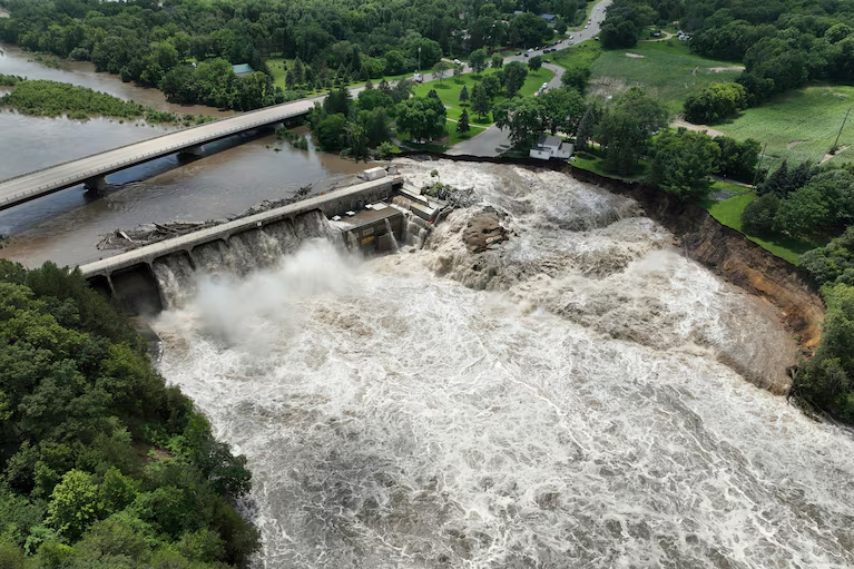
The Rapidan Dam near Mankato, Minn., is at risk of “imminent failure” after the flooding of the Blue Earth River, officials warned on June 24. (Video: AP)
Rising waters on the Blue Earth River in Minnesota washed out a portion of the Rapidan Dam near the town of Mankato, 50 miles southwest of Minneapolis, as floods inundated parts of the Midwest.
“The water cut away some land at the west side and is now free flowing,” Jeremy Brennan, chief deputy at Blue Earth County Sheriff’s Office, told The Washington Post. Downstream residents had been notified of the possibility of dam failure, but evacuation orders were not needed, officials said.
The situation was the latest brought on by days of torrential rains last week, triggering flooding that killed at least two people. In addition to a death South Dakota Gov. Kristi L. Noem (R) confirmed but did not provide details about, authorities in Clay County, Iowa, said they recovered the body of a man Monday whose truck had been swept away in floodwaters, the Des Moines Register reported.
Flooding that spread across parts of Iowa, South Dakota and Minnesota this past weekend is forecast to worsen in some areas Tuesday as rivers continue to rise, and meteorologists warned that any additional rain from possible thunderstorms could extend or heighten the risks of inundation.
In Minnesota, authorities said emergency services teams were on the ground and monitoring the situation closely.
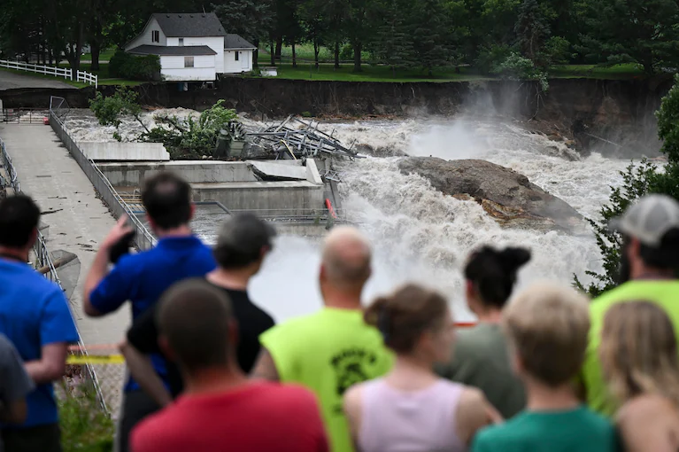
People gather to look at the fast-moving water as a house sits near the edge of the Blue Earth River in Minnesota. (Aaron Lavinsky/Star Tribune/AP)
“There’s a serious situation in and around Mankato with the Rapidan Dam potentially failing,” Sen. Amy Klobuchar (D) said in a post on social media. Minnesota’s Star Tribune newspaper reported that the dam was in “imminent failure condition,” citing Blue Earth County officials.
Video from the scene showed a lone house on the bank, close to fast-moving water carrying tree branches and structural debris.
“Nobody has dealt with such a situation before. Managing the people who are coming out to view the dam and keeping them safe is a big challenge,” Brennan said.
The National Weather Service’s flash flood warning for the Blue Earth River was in place until Tuesday morning local time, the agency said.
Officials from the city of North Mankato said they built a 34.6-foot earth wall levee as a precautionary measure. “Currently the river level is at 28.92 ft and predicted to crest at 29.6 ft on Tuesday,” the city said in a statement posted on social media.
“If the Rapidan Dam does fail, engineers on-site predict an increase in the river levels of 6 inches to 2 ft, depending on location downstream,” it said at 6:19 p.m. local time Monday.
Minnesota Gov. Tim Walz says the structural integrity of Rapidan Dam has been in question “for a long time.” (Mark Vancleave/AP)
The Rapidan Dam is more than 100 years old. Damage from regular flooding over the years has prompted questions over its future, according to the Blue Earth County website.
“The structural integrity of the dam has been in question for a long time,” Minnesota Gov. Tim Walz (D) said Monday.

By Niha Masih Niha Masih is a reporter at The Washington Post’s Seoul hub, where she covers breaking news in the United States and across the world. Previously, she was The Post’s correspondent in India, where she covered the rise of majoritarian nationalism, conflict in Kashmir, the covid crisis and digital surveillance of citizens. Twitter

By Scott Dance Scott Dance is a reporter for The Washington Post covering extreme weather news and the intersections between weather, climate, society and the environment. He joined The Post in 2022 after more than a decade at the Baltimore Sun. Twitter
Here’s why floods are inundating the Midwest right now
Flooding that hit parts of Minnesota, Iowa and South Dakota is forecast to worsen Monday. Rivers are expected to crest Tuesday or Wednesday.
By Scott Dance
Updated June 24, 2024 at 4:15 p.m. EDT|Published June 24, 2024 at 11:46 a.m. EDT
Roads, homes and other structures were flooded in Rock Valley, Iowa, on June 22. (Video: Storyful)
Flooding that spread across parts of Iowa, South Dakota and Minnesota this past weekend is forecast to worsen Monday and Tuesday as rivers continue to rise, and meteorologists warn that any additional rain from possible thunderstorms could extend or heighten the risks of inundation.
The floods are the product of torrential rain across parts of the Missouri and Mississippi river basins since Thursday, dumping widespread totals of 10 inches to as much as 18 inches of rain, said Todd Heitkamp, meteorologist in charge at the National Weather Service’s Sioux Falls, S.D., forecast office. Soils were already saturated from months of wetter-than-average conditions before storms fueled by intense Gulf of Mexico moisture lingered over the region from Thursday into Saturday.
That sent runoff coursing into streams and rivers and overwhelming levees in some areas, Heitkamp said. Rivers are expected to crest Tuesday or Wednesday at moderate to record flood stages, forecasters said.
Streamflows are running “much above normal … suggesting that while soils are still wet, there is limited storage capacity to store additional rainfall,” forecasters wrote Monday. “Each additional round of rainfall will serve to further compound the flood potential.”
At the same time, intense heat that has been shifting around the country for the past week is forecast to bake the region as it manages the rising waters. Temperatures across the Upper Midwest were forecast to peak in the 90s, with high humidity expected to make it feel close to 110 degrees Monday. That will produce “unpleasant to dangerous” conditions for those spending time outdoors, the Weather Service warned.
The Rapidan Dam near Mankato, Minn., is at risk of “imminent failure” after the flooding of the Blue Earth River, officials warned on June 24. (Video: AP)
Heat advisories stretched across the Mississippi River basin Monday, from Minnesota and South Dakota to the Gulf Coast.
In Minnesota on Monday, authorities were watching closely as rising waters on the Blue Earth River, not expected to crest until Tuesday, washed out a portion of the Rapidan Dam near the town of Mankato, 50 miles southwest of Minneapolis. Officials said the dam’s integrity was intact and being monitored, but the town of North Mankato was building a temporary levee to protect itself in case of the dam’s failure. Sen. Amy Klobuchar (D) called it “a serious situation.”
Flood damage was already significant and included a collapsed rail bridge that connected South Dakota and Iowa.
Flooding in South Dakota has led to significant destruction, including the collapse of a key bridge and widespread damage to homes and infrastructure. (Video: Reuters)
Iowa Gov. Kim Reynolds (R) said the waters damaged or destroyed more than 1,900 homes across at least 22 counties in the state. After surveying the toll by air on Saturday, Reynolds said “the devastation is widespread.” She said rivers were rising above records set in the Great Flood of 1993, which spread across nine states, killed 50 people and caused $15 billion in damage.
At least one death was linked to the flooding in South Dakota, Gov. Kristi L. Noem (R) said Sunday. She did not provide details.
A rapid surge of floodwaters within about 30 minutes destroyed an unknown number of homes in North Sioux City, S.D., on Sunday night, the Argus Leader reported.
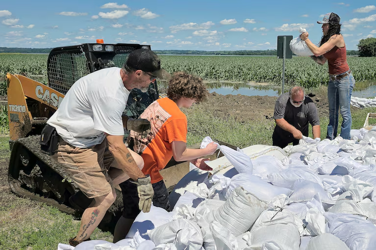
Volunteers toss sandbags into the bucket of a loader that will take them to be used to reinforce a berm on the northeast side of Jefferson, S.D., on Sunday. (Tim Hynds/AP)
Sioux Falls, S.D., Mayor Paul TenHaken earlier urged residents to conserve water as the floods had caused unprecedented stress to the city’s wastewater system, forcing authorities to release some untreated sewage into the Big Sioux River, the paper reported.
“Our wastewater collection and treatment systems remain strained, but they are back to a point where we believe it is manageable,” Mark Cotter, Sioux Falls’ director of public works, said in a statement.
Flooding caused widespread road closures across the region, including a brief shutdown of a portion of Interstate 29.
Thursday and Friday was the wettest two-day period on record for two South Dakota communities, Mitchell and Sioux Falls, with 7.7 inches and 6.49 inches of rainfall recorded within 48 hours, the Weather Service said.
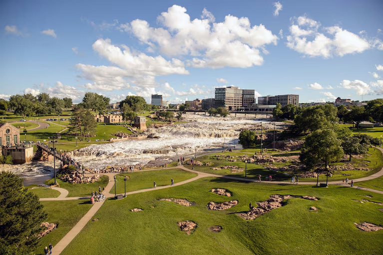
Falls Park in Sioux Falls, S.D., was submerged on Saturday after days of heavy rain. (Josh Jurgens/AP)
As of Monday, rivers across the Missouri River basin were at major flood stage: the James, Vermillion and Big Sioux rivers in South Dakota and the Des Moines and Little Sioux rivers in southwestern Minnesota and northwestern Iowa, according to National Oceanic and Atmospheric Administration data.
Flood warnings were in effect in those areas “until further notice,” the Weather Service warned. Flood watches were in effect along the upper Mississippi River in Minnesota and Wisconsin.
Isolated storms are possible Tuesday afternoon, meteorologists said, with the greatest chances for significant rain expected Thursday night into Friday.
“If you get any additional rainfall, it’s a punch in the gut,” said Heitkamp, the Sioux Falls, S.D., meteorologist.
More:
Here are more “ETs” recorded from around the planet the last couple of days, their consequences, and some extreme temperature outlooks, as well as any extreme precipitation reports or outlooks:
Here is More Climate News from Tuesday:
(As usual, this will be a fluid post in which more information gets added during the day as it crosses my radar, crediting all who have put it on-line. Items will be archived on this site for posterity. In most instances click on the pictures of each tweet to see each article. The most noteworthy items will be listed first.)