The main purpose of this ongoing blog is to track planetary extreme, or record temperatures related to climate change. Any reports I see of ETs will be listed below the main topic of the day. I’ll refer to extreme or record temperatures as ETs (not extraterrestrials).😉
Main Topic: Outlook for Dangerous Heatwave Hess
Dear Diary. I have sone good news as the calendar flips from August into September into meteorological fall. The dangerous heatwave the I’ve dubbed for oil company Hess should end or substantially weaken in a few days, but first near record heat and humidity will be experienced from the Midwest and Southeast into the Northeast.
Here are current National Weather Service advisories in association with Hess, which is a dangerous, major CAT3 on a scale from 1 to 5:

Sone relief has come to the south-central states where a disturbance coming from the Gulf of Mexico has cooled temperatures but barely below heat advisory criteria:
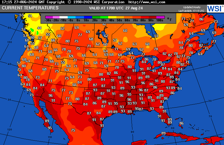
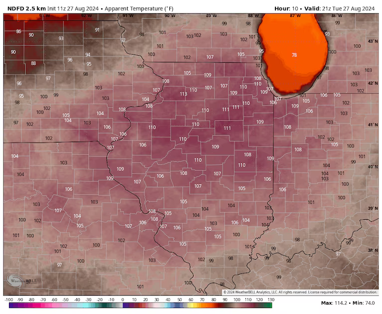
But elsewhere the heat is on:
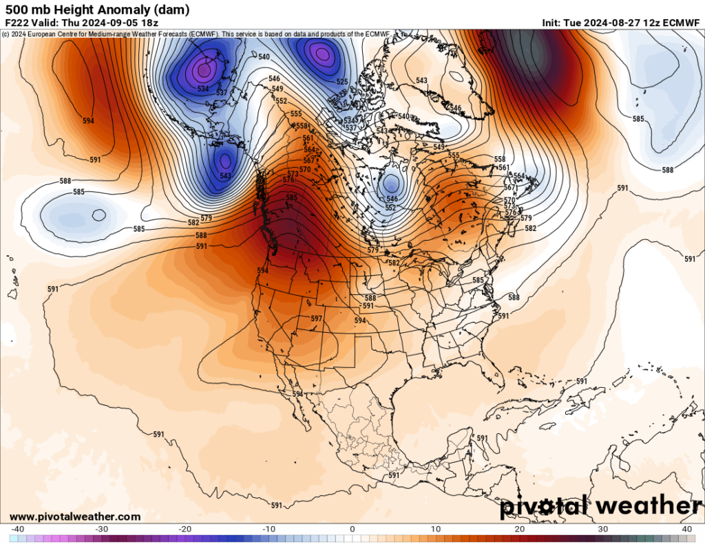
As far as Heatwave Hess’ heat dome goes, the thing peaked at near 600 decameters over Missouri on Sunday:

This heat dome will drift southward and gradually weaken going into the Labor Day holiday weekend:

A new heat dome will build over the Southwest where we may have a new named heatwave if the system grows from a CAT2 to a dangerous major CAT3:
Let’s not get too far ahead of ourselves. The Washington post has a good writeup on Heatwave Hess’ consequences and potential record temperatures the next few days:
Heat wave grips Midwest, Mid-Atlantic and South: City forecasts – The Washington Post
Record heat is closing out August in the Midwest, East: City-by-city forecasts
Heat indexes over 100 are forecast for St. Louis, Chicago, Detroit, Nashville, Atlanta and D.C. through midweek.

Heat rising from the pavement distorts the view on Pennsylvania Avenue in Washington in June. Another heat wave is hitting the eastern United States this week. (Jahi Chikwendiu/The Washington Post)

August 27, 2024 at 11:30 a.m. EDT
About 75 million people from the Midwest to the Mid-Atlantic coast are under heat alerts as abnormally high temperatures blast the eastern United States.
The heat is sprawled over the region as climatological summer, defined as June to August, comes to a close. Along the East Coast, it caps one of the 10 hottest summers on record. Parts of the Midwest have been cool by comparison, but this final summer week is offering some of the hottest air to date.
Excessive-heat warnings cover much of the northern half of Illinois, southern Wisconsin and eastern Iowa, including Chicago; Iowa City; Champaign, Ill.; and South Bend, Ind. They also are in effect around Philadelphia.
Heat advisories surround the heat warnings in both regions, running from central Missouri to eastern West Virginia and the southern Great Lakes, then across parts of the Mid-Atlantic, where they may be expanded into Wednesday.
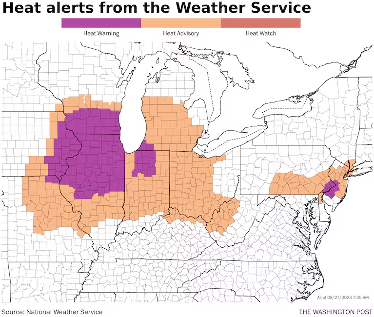
Heat alerts as of Tuesday morning. (Ian Livingston/The Washington Post)
Temperatures reaching the mid-90s to around 100 are forecast to be widespread from the Midwest to the Ohio Valley and into the South on Tuesday. The National Weather Service predicts a Level 4 out of 4 HeatRisk from St. Louis to Chicago and around Grand Rapids, Mich.
East of the Appalachians, highs are also expected to rise well into the 90s on Tuesday before climbing even more on Wednesday.
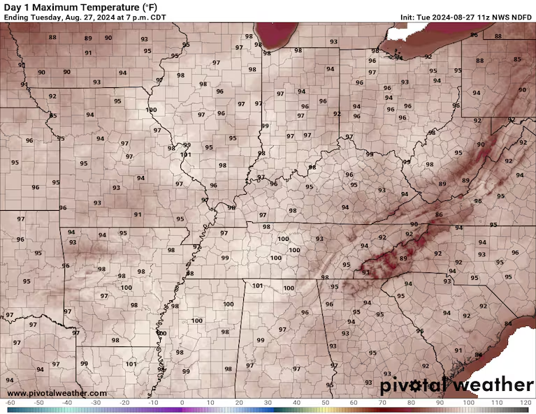
The high temperature forecast for Tuesday from the Weather Service. (Pivotal Weather)
Highs on Wednesday should be near the century mark in the Mid-Atlantic, near 90 in southern New England and from the mid-90s to around 100 through portions of the Ohio Valley and South.
Factoring in humidity, it will feel 5 to 15 degrees hotter.
Amid the heat, a stagnant air mass is delivering widespread poor air quality, especially around urban areas. Code orange alerts for unhealthy air are in effect for all of the cities listed below, except Detroit.
Record high temperatures — which have already been numerous over the past week — are forecast to continue being set through Thursday or Friday.
Here’s how hot it will be in six cities where some of the most intense heat is predicted through midweek:
St. Louis — heat advisory, maximum temperature of 102
Hot, humid and hazy conditions will dominate, before a cold front brings scattered storms Thursday night. Heat indexes will rise to around 110 on Tuesday.
- Tuesday: 102 high
- Wednesday: 76 low / 94 high
- Thursday: 76 low / 97 high
The heat index forecast for Tuesday afternoon from the Weather Service. (weatherbell.com)
Chicago — excessive-heat warning, maximum temperature of 98
The Windy City has avoided regular bouts of extreme this summer; its highest temperature so far was 97 degrees, reached in June. Tuesday’s temperatures may be the highest of the season, with a predicted heat index of 110.
- Tuesday: 98 high
- Wednesday: 73 low / 84 high
- Thursday: 69 low / 86 high
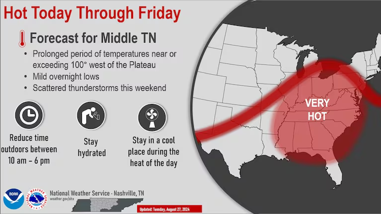
Nashville — maximum temperature of 102
Near the heart of the heat dome over the next few days, clouds are few and temperatures are very high. If it does hit 100-plus for three days in a row, as forecast, it will be the city’s longest streak in August since 2007 and longest at any time since 2012.
- Tuesday: 100 high
- Wednesday: 73 low / 102 high
- Thursday: 73 low / 101 high
Atlanta — maximum temperature of 96
Like Nashville, Atlanta sits near the core of the heat dome, so it has minimal rain chances until perhaps Friday. Factoring in moderate humidity, it will feel about 5 degrees hotter than the actual temperature.
- Tuesday: 95 high
- Wednesday: 72 low / 96 high
- Thursday: 73 low / 96 high
Detroit — heat advisory, maximum temperature of 92
Monday’s near-record high of 92 was the second-hottest of the year in the Motor City, and it could get there again Tuesday ahead of a cold front. Humidity will make it feel more like 100 during the afternoon.
- Tuesday: 92 high
- Wednesday: 73 low / 85 high
- Thursday: 66 low / 81 high
Washington, D.C. — maximum temperature of 100
If the nation’s capital hits 100 on Wednesday, as forecast, it will set a record for the date and join only six other instances this hot this late in the season. If it reaches the century mark, 2024 will join only three other years since 1872 in observing triple-digit heat in June, July and August. Factoring in humidity, it will feel more like 105 on Wednesday.
- Tuesday: 93 high
- Wednesday: 74 low / 100 high
- Thursday: 76 low / 89 high

100-degree highs are forecast in the Washington and Baltimore areas Wednesday. (Ian Livingston)
Jason Samenow contributed to this report.
More on extreme heat
Use our tracker to see your city’s extreme heat risk.
How to stay safe: It’s better to prepare for extreme heat before you’re in it. Here’s our guide to bracing for a heat wave, tips for staying cool even if you don’t have air conditioning, and what to know about animal safety during extreme heat. Traveling during a heat wave isn’t ideal, but here’s what to do if you are.
Understanding the science: Sprawling zones of high pressure called heat domes fuel heat waves. Here’s how they work. You can also read more about the link between weather disasters and climate change, and take a look at what extreme heat does to the human body.
Here are more “ETs” recorded from around the planet the last couple of days, their consequences, and some extreme temperature outlooks, as well as any extreme precipitation reports:
Here is More Climate News from Tuesday:
(As usual, this will be a fluid post in which more information gets added during the day as it crosses my radar, crediting all who have put it on-line. Items will be archived on this site for posterity. In most instances click on the pictures of each tweet to see each article. The most noteworthy items will be listed first.)