The main purpose of this ongoing blog will be to track planetary extreme, or record temperatures related to climate change. Any reports I see of ETs will be listed below the main topic of the day. I’ll refer to extreme or record temperatures as ETs (not extraterrestrials).😪
Main Topic: Heatwave Pemex Moves Westward Again
Dear Diary. Before we get into the nuts and bolts of what is happening with the longest heatwave of this season for the U.S. that I’ve dubbed Heatwave Pemex, I need to get something off my chest. My old place of business at The Weather Channel is doing wall to wall coverage of Hurricane Erin, which at most will brush the Outer Banks of the Carolinas, causing some beach erosion and dangerous rip tides up and down the East Coast. If folks are smart and avoid ocean perils, there won’t be any fatalities from Erin, nor will there be any significant property damage at all. Yet we have a major heatwave affecting a huge chunk of the U.S. without much coverage. Why? Because heatwaves aren’t sexy and don’t garner high T.V. ratings.
Heat remains the number one weather killer in the U.S. That is why I have suggested that major heatwaves get names just like hurricanes. Unfortunately, Heatwave Pemex will probably kill far more than Hurricane Erin. We are running a race against time with climate change to get all dwellings outfitted with cheap A.C. to protect people from excess heat. But you can’t protect those working outside in record heat unless people in construction are aware of danger…another reason to name heatwaves.
All that said, let’s look at what is happening with major CAT3 Heatwave Pemex and its future. Here is the state of watches and warnings across the United States:
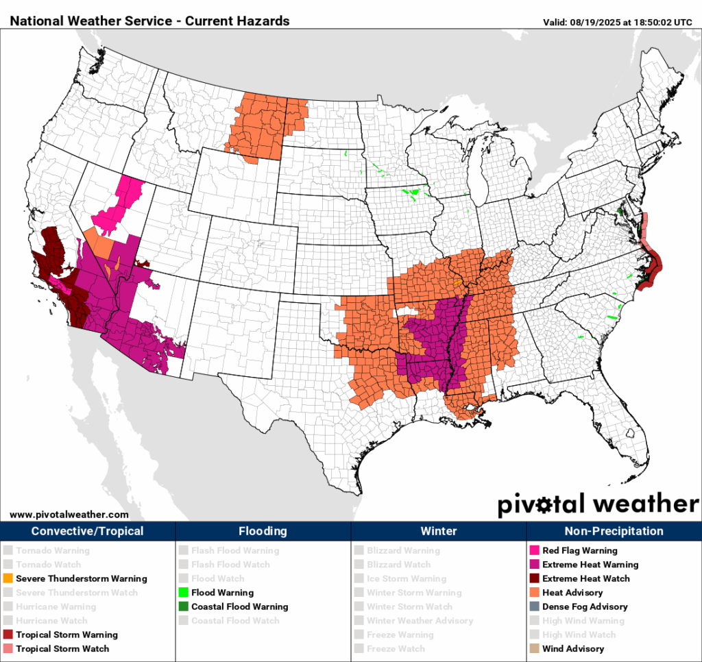
The Southwest will get the brunt of Pemex this week while we start to get some relief in the nation’s mid-section since its heat dome will retrograde to the west:
Here are more details from the Los Angeles Times:
SoCal’s worst heat wave this year: How long will it last and where will be hottest?

Adrian Garcia walks with her 2-year-old son, Benjamin Hernandez, at Lake Balboa. (Al Seib / For The Times)

By Grace Toohey Staff Writer Follow
Aug. 19, 2025 11:03 AM PT
- The prolonged, dangerous heat wave is expected to begin broiling much of Southern California Wednesday, peaking Thursday and Friday.
- A red flag warning, an alert that indicates conditions ripe for explosive fire growth, has been issued for Los Angeles and Ventura counties’ mountains and foothills.
A prolonged and potentially dangerous heat wave is forecast to bake Southern California this week, raising health and fire concerns across the region as forecasters warn this is expected to be the most significant period of hot weather this year, thus far.
Temperatures across interior Southern California will climb dramatically over the next few days, providing little opportunity for overnight relief and creating instability in the atmosphere that can foster extreme fire behavior and growth.
Weather officials and experts are warning residents to make plans now for air conditioning access, ways to receive emergency alerts and evacuation, if necessary.
What to expect
This heat wave is bringing dual threats to the Southland. The forecast of triple-digit heat is expected to bring acute health risks, especially for vulnerable populations, and it will elevate the threat of fast-growing wildfires, if one ignites.

The summer’s most dangerous heat wave is set to broil SoCal, elevating fire and health risks
Aug. 18, 2025
Much of the region is under an extreme heat warning through the weekend, while a red flag warning has been issued for the Los Angeles and Ventura county mountains and foothills.
When is the heat coming? How long will it last?
Wednesday: Almost all of the region’s extreme heat alerts begin Wednesday, when forecasters say temperatures will begin to rise. Much of southwest California is under an extreme heat watch, warning of “dangerously hot conditions.”
A red flag warning, an alert that indicates conditions ripe for explosive fire growth, has been issued for Los Angeles and Ventura county mountains and foothills beginning Wednesday.
Thursday and Friday: Temperatures are expected to peak Thursday and Friday, when areas inland from the coast, including downtown L.A., will be under an extreme heat watch. In those areas, highs are expected to reach 95 to 105 degrees; the L.A. Valleys could reach up to 110. Officials warn that overnight temperatures will also remain high, possibly in the 70s for much of L.A. County.
The heat wave will also expand, with much of inland Orange County, the Inland Empire, San Diego County valleys and the southern San Joaquin Valley under an extreme heat watch beginning Thursday. Orange County’s interior can expect highs up to 95 degrees, San Diego County valleys could get up to 102 and the Inland Empire and Central Valley could see highs up to 106 degrees.
Friday through Sunday: Officials say there will also be a chance for thunderstorms from Friday through the weekend. The strongest chance for these monsoonal storms, around 20%, will be in the mountains of L.A. and San Bernardino counties. They could bring localized flooding as well as lightning strikes, which could spark new fires.
Saturday and Sunday: Many of the heat and fire weather warnings are set to expire by the weekend, but officials say they could be extended. And even if the most extreme warnings expire, officials warn temperatures will remain high.
Early next week: Forecasts are still uncertain, but it appears that a slight cooldown will begin next week, though temperatures will remain above average for this time of year.
What’s the fire risk?
A red flag warning has been issued for Los Angeles and Ventura county mountains and foothills beginning Wednesday at 9 a.m. It remains in effect through Saturday night.
A fire weather watch — a step below a red flag warning — is in effect for the mountains and foothills of Santa Barbara and San Luis Obispo counties.
“Unseasonably strong instability will create a fire environment capable of producing explosive fire behavior through significant vertical plume growth,” the alerts said. Those conditions will be particularly challenging when combined with low relative humidity, little cooling at night and a dry landscape.
While major winds aren’t in the forecast, the alerts say that there will be some local breezes in the afternoons that could “exacerbate the spread of any plume-dominated fires, and add to the potentially dangerous fire-weather environment.”
The chance for thunderstorms Friday, Saturday and Sunday will only add to the dangerous conditions, with the possibility of lightning-caused fires.
Where will see the worst heat?
- Southeast California, including the Mojave Desert and the Yucca Valley, is under an extreme heat warning, with the weather service warning of major-to-extreme heat risk. Temperatures are expected to reach 110 in Twentynine Palms, 115 in Barstow and 120 in Death Valley. This most extreme heat will extend into northwest Arizona and southern Nevada.
- The Apple and Lucerne valleys are expected to see temperatures up to 108 degrees on Thursday, Friday and Saturday.
- Some of L.A. County’s hottest areas, including Santa Clarita, Palmdale and Woodland Hills, are expected to hit 105 to 108 on Thursday and Friday.
- Paso Robles could reach 107 on Thursday.
How are officials preparing?
Los Angeles officials are gearing up for the heat wave by adding four cooling centers with air conditioning and water to its network of libraries and parks that will be open to the public.
Beginning Wednesday, the city will open senior citizen centers in Canoga Park and North Hollywood from 10 a.m. to 9 p.m., which will both be open through at least Saturday. On Thursday and Friday, the city will also open the Pecan Recreation Center and the Algin Sutton Recreation Center as cooling centers.
A map of Los Angeles’ cooling centers can be found here.
The city’s fire department said it is planning to preposition resources throughout the city and has added a new crew of 26 full-time firefighters focused on wildfires.
Tips to stay safe during extreme heat:
- Avoid the outdoors and stay out of the sun, especially during the heat of the day. Opt for outside activities in the morning or late evening when temperatures are lower.
- Stay hydrated.
- Wear lightweight and loose fitting clothing.
- Know the signs and symptoms of heat-related illness, and seek help right away if needed.
- Check in on your neighbors and the most vulnerable, including children, the elderly, people living on the street, pregnant people and those with chronic health conditions, all of whom are most susceptible to heat-related illness.
Grace Toohey is a reporter at the Los Angeles Times covering breaking news for the Fast Break Desk. Before joining the newsroom in 2022, she covered criminal justice issues at the Orlando Sentinel and the Advocate in Baton Rouge. Toohey is a Maryland native and proud Terp.
Here are more “ET’s” recorded from around the planet the last couple of days, their consequences, and some extreme temperature outlooks, as well as any extreme precipitation reports:
Here is More Climate News from Tuesday:
(As usual, this will be a fluid post in which more information gets added during the day as it crosses my radar, crediting all who have put it on-line. Items will be archived on this site for posterity. In most instances click on the pictures of each tweet to see each article. The most noteworthy items will be listed first.)