The main purpose of this ongoing blog will be to track planetary extreme, or record temperatures related to climate change. Any reports I see of ETs will be listed below the main topic of the day. I’ll refer to extreme or record temperatures as ETs (not extraterrestrials).😜
Here is a new feature for this blog, which I will add daily. This is the latest inciteful Green News Report from my friends Desi Doyen and Brad Friedman at Progressive Voices. Hit ‘More info,’ listen, then hit return to see my daily topics:

Green News Report with Brad Friedman & Desi Doyen
Episode: 10/13/2026 — More info…
Dear Diary. It’s now mid-October, so we look to traditional weather and climate for dreaded Santa Anna winds in California, which dry vegetation and spur on and build any started destructive wildfires. Right on cue this year we have Santa Ana winds forecast for California this week:
There is one aspect of climate change which may actually work in California’s favor. It makes sense that as the continental U.S. warms, high pressure building over the Intermountain West and Great Basin will warm and won’t be as strong, so the pressure gradient will be less, and thus winds roaring into California won’t be as strong. However, such dynamics might be just delayed into November as summer conditions encroach well into fall. In any case, threats from Santa Ana winds will continue through the rest of the 21sf century.
Here are more details from the Los Angeles Times:
Climate change is weakening the Santa Anas, UCLA research finds – Los Angeles Times
Climate change is weakening Santa Ana winds — but won’t save SoCal from devastating fires
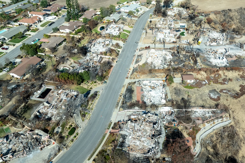
The 2024 Mountain fire, fueled by powerful Santa Ana winds, covered nearly 20,000 acres within two days.
Brian van der Brug / Los Angeles Times)
Staff Writer Follow
Oct. 15, 2026 3 AM PT
Southern California’s specter of ruinous wildfire is back. The first Santa Ana winds of the season are expected to bring 20- to 40-mph winds, and gusts potentially exceeding 60 mph to valleys and coastal mountain ranges through Friday afternoon.
Scientists have projected that by 2100, human greenhouse gas pollution will cut back the number of days these winds blow. Now, a research team led by UCLA scientists has found it’s already happening.
The Santa Anas are driven in part by temperature differences between the cool deserts in Utah and Nevada and the warm California coast. With climate change warming the desert more than the ocean, there are fewer weak and moderate Santa Ana wind events, but this is unlikely to diminish the intensity of extreme wind-driven fires that pose a major threat to Southern California communities, according to their paper in the American Geophysical Union journal Earth’s Future.
There is intense interest in the Santa Anas in Southern California. It’s these winds that turn routine fires into blazes capable of jumping past firefighters’ defenses and ripping through communities faster than residents can drive. They keep residents up at night as they rattle windows and wail through canyons. They activate armies of volunteers along the coast to catch arsonists and address careless behavior. They can even convince Topanga Elementary School to move classes out of the mountains to keep kids out of harm’s way.
That global warming is diminishing them might sounds counterintuitive — climate change, after all, is worsening much of the world’s extreme weather. Yet it’s true. Unfortunately, the lessening is not enough to protect us from devastating fires: Right now, it’s erasing only 1 in every 200 wind events. By the end of the century, it will snuff out 1 of every 10 or 20, and only the milder ones.
“That’s not going to save you much,” said Tom Delworth, senior scientist at the National Oceanic and Atmospheric Administration’s Geophysical Fluid Dynamics Laboratory, “because it’s really the severe ones that do all the damage, and we see no signs those will decrease.”
As the winter winds blow, they’re increasingly hitting dry conditions lingering from summer as climate change makes rain more erratic — a dangerous combination.
“That means that the window of opportunity for wildfire may still be expanding,” said Alexander Gershunov, a research meteorologist at UC San Diego’s Scripps Institution of Oceanography and a co-author on the UCLA-led study. The 2025 L.A. fires, which occurred under extremely dry conditions all the way in January, “are probably the poster fires for a warmer world,” he said.
How the Santa Ana winds are made
The Santa Anas begin in the desert lands of the Great Basin. As the fall brings shorter days and longer nights, the ground begins to cool. Air close to the ground cools with it. As the cold air settles, pressure increases. On the coast, the air stays warmer and thinner as the ocean emits the heat it’s stored through the summer. This temperature difference creates a pressure difference.
The high pressure air in the Great Basin races downhill to the coast. The elevation change compresses it — the way a plastic water bottle you closed in Tahoe crinkles as it reaches Los Angeles. That adds energy to the air, warming it up about 20 degrees along its journey. Warmer air wants to hold more water, so the air sucks moisture from vegetation. The canyons of the San Gabriel and Santa Monica mountains funnel the air toward the coastline in a perfect state to fuel fire: warm, fast and thirsty.
L.A. fires spur wind research
For many scientists, the Eaton and Palisades fires were a wake-up call that far more research was needed into what drives SoCal fires.
But piecing together how climate change might be influencing the Santa Anas is difficult. Researchers have to understand how large-scale global shifts, driven by emissions, are affecting unique local weather patterns in sometimes unintuitive ways.
A single pixel on a map created by a global climate simulation could cover thousands of square miles — larger than L.A. County. With jagged mountains and canyons smoothed out to almost nothing, it’s just too blurry to accurately show the Santa Anas.
Two research groups used different techniques to get greater detail than ever before.
A July 2025 paper out of Delworth’s group at NOAA took advantage of cutting-edge global models to push the pixel size down to 240 square miles, about the size of the San Fernando Valley. They found climate change would kill about 10% of Santa Anas by the end of the century, while making the winds drier.
After so many L.A. fire failures, this week’s Santa Ana winds test whether officials can do better
Oct. 14, 2026
The new UCLA paper instead used a global model with larger pixels that the researchers fed directly into a detailed local model. Although this can lose some of the intricate ways the global climate influences local weather events, the team was able to achieve a resolution of just 30 square miles, about the size of Glendale. They found climate change would eliminate only about 5% of the wind events by the end of the century, particularly lower wind-speed Santa Anas.
The effect is small. But it’s still important. Because it’s wind that turns beatable fire into impossible fire.
The challenge of Santa Ana fires
Jack Cohen, a retired U.S. Forest Service fire scientist, remembers the Santa Ana-fueled 1980 Panorama fire clearly.
Burning in the San Bernardino Mountains, it was racing toward the suburban North Park neighborhood. Firefighters lined up along the community’s edge, prepared to stop the flames’ march.
But before the fire reached them, homes three blocks behind them began burning.
Cohen would go on to pioneer our understanding of the Santa Anas’ underestimated weapon: embers.
Imagine an ignition on a shrubby hillside next to a neighborhood on a typical hot and dry summer day. The fire marches forward, gaining more territory. The firefighters establish lines that stop the fire before it reaches the neighborhood.
Oct. 2, 2026
LAFD acknowledges missteps involving Palisades fire following independent investigation
Now imagine the same hot and dry conditions, but with the Santa Anas whipping at 40 miles an hour. The wind can push the fire front more aggressively, sure, but that’s no longer the firefighters’ most pressing worry. Now, that fire is acting as an ember generator. The winds can carry those embers over a mile.
Now, firefighters have to defend essentially every home in the community from a torrent of embers, a task no fire department can handle.
“Your ability to control the fire at a particular line or point just goes away,” Cohen said. “It doesn’t matter how many engines you’ve got. You’re going to get overwhelmed.”
Fireproofing surges as a priority
This is why Southern California fire officials who oversee some of the most well-trained firefighters in the world are increasingly focusing on helping homeowners fortify their properties against embers. Cohen calls the roughly 100 feet around a house the home ignition zone. This is the area where, if an ember lands and ignites something — a pile of firewood, a trash can or a deck — fire can break into the house and burn it down.
To reduce the chance of your home succumbing to embers, fire experts recommend, in the yard, removing dead plant material and combustible items like wooden fences and sheds, separating trees and plants from one another and hard-scaping within 5 feet of the house. As for the house, experts advise covering vents where embers could sneak in with mesh, using multi-pane windows that can resist extreme heat, and building walls and roofs out of noncombustible materials.
The good news: “That’s where we have the greatest control, through preparation,” Cohen said.


Noah Haggerty is an environment and science reporter at the Los Angeles Times covering wildfire in the American West. A graduate of Northeastern University, he has a background in physics research, focusing on spacecraft propulsion and fusion energy. Haggerty joined The Times in 2024 as an AAAS Mass Media Fellow.
Here are some “ETs” recorded from around the U.S. the last couple of days, their consequences, and some extreme temperature outlooks, as well as any extreme precipitation reports:
Here is More Climate News from Thursday:
(As usual, this will be a fluid post in which more information gets added during the day as it crosses my radar, crediting all who have put it on-line. Items will be archived on this site for posterity. In most instances click on the pictures of each tweet to see each article. The most noteworthy items will be listed first.)