The main purpose of this ongoing blog will be to track planetary extreme, or record temperatures related to climate change. Any reports I see of ETs will be listed below the main topic of the day. I’ll refer to extreme or record temperatures as ETs (not extraterrestrials).😜
Here is a new feature for this blog, which I will add daily. This is the latest inciteful Green News Report from my friends Desi Doyen and Brad Friedman at Progressive Voices. Hit ‘continue reading,’ listen, then hit return to see my daily topics:

Green News Report with Brad Friedman & Desi Doyen
Episode: 11/3/2026 — More info…
Dear Diary. The good news is that the drought in the southwestern U.S. northward into Colorado has all but ended due to recent heavy rain. The bad news is that deluges were so heavy that water rescues had to be performed in some localized areas. It looks like the rainstorm systems were energized by our record El Niño since the southern U.S. Jet storm is already energized- a big marker for an El Niño.
Residents of California and the Southwest should be fearful of historic rainfall forecast to fall due to that El Niño. And that El Niño, in my opinion, is made warmer by climate change.
For more details here is a recent Grist article (For charts that I did not repost, hit the following link.):
The Southwest’s extreme flooding foreshadows a wild El Niño winter | Grist
Extreme flooding in the Southwest foreshadows a wild El Niño winter
Historically, the oceanic phenomenon boosts precipitation in the southern U.S. Here’s a glimpse at the pain to come.
Matt Simon Senior Staff Writer
Published Nov 05, 2026
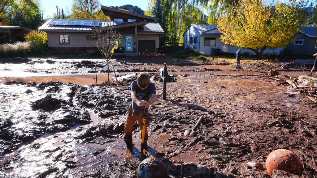
The Southwest just got way too much of a good thing. Last weekend, a ferocious storm inundated communities and killed at least four people. Though precipitation is an essential component of Arizona’s desert climate, the state got two or three months’ worth of it in just a few days — far more than human infrastructure could handle all at once. Since September 20, an astonishing 28.84 inches of rain has fallen on Clovis, New Mexico, compared to its historical average of just 3.3 inches.
“This weekend was just adding more on the rough times that those communities in Southwest Colorado and Arizona and Utah and New Mexico have been having recently,” said Russ Schumacher, director of the Colorado Climate Center at Colorado State University, who’s also the state climatologist. “I think the El Niño connection is pretty clear.”
Indeed, that band of warm water in the Pacific could be priming much of the southern United States for a winter of increased precipitation, according to the National Oceanic and Atmospheric Administration’s seasonal outlook. “Could an event like this have happened in a non-El Niño year?” asked Michael A. Crimmins, a climatologist at the University of Arizona. “It could have, but it would have been a lot harder to pull all of the ingredients together at the same time, and would have been a lot less likely.”
The looming problem this winter is heat, oddly enough. The unfolding El Niño is already the strongest on record, and it could get stronger still in the next few months. Although that amounts to just a handful of extra degrees in the Pacific, it injects a tremendous amount of energy into the atmosphere, scrambling weather the world over. The phenomenon is so influential, in fact, that it has helped cancel hurricanes over in the Atlantic, by messing with winds high up in the atmosphere. Accordingly, this year shattered the record for the latest first hurricane in a season by nearly a month. Normally by this time of year we’d have seen six of these cyclones, but 2026 has still only produced one.
The Southwest, though, gets no such relief from inclement weather. In addition to adding heat to the sky, the warmer waters of El Niño also increase atmospheric moisture. Even beyond the El Niño, temperatures in the Pacific have been running extra hot, which explains why the western part of the ocean has produced 10 hurricanes this season even as the Atlantic has remained quiet. (Overall, more than 90 percent of the excess heat that humans have pumped into the atmosphere has been absorbed by the oceans.)
All this warm water means more moisture for the weather patterns that have been moving into the Southwest over the last month. A separate system in late October, for instance, became one of the most extreme storms in Colorado’s history, pelting higher elevations with up to 8 inches of rain in four days, causing widespread destruction. “It’s just really extreme amounts of water vapor in the atmosphere that have been aimed into the Southwest in each of those storms,” Schumacher said.
This autumn precipitation primed Arizona, Colorado, and other Southwestern states for yet more destruction this past week. For one, rivers were already running high, then ran all the higher. And two, if soils are soaked, a follow-up bout of rain will run off and cause flooding. “We get the second storm, just a little bit after the first one, then everything was primed for even worse flooding this time around,” Schumacher said.
In mountainous terrain, this gets especially dangerous, as the topography funnels rainwater into raging torrents. “If you hike around the Southwest, you’re going to see out-of-place boulders all over the place,” Crimmins said. “Water put it there. Maybe it was 5,000 years ago or something like that, but water moves. We can have really epic flash flooding.”
The one silver lining here is that any increased precipitation from this El Niño could bring drought relief to much of the southern U.S., according to NOAA’s projections. Climate change is not only exacerbating these ongoing dry spells — hotter temperatures also increase evaporation from reservoirs. At the same time, populations are growing in the Southwest, meaning more people demanding more water.
With these factors conspiring, the Colorado River’s two largest reservoirs, Lake Powell and Lake Mead, are approaching the point of collapse. The potential for more rainfall this winter might help fill them, Schumacher said, but it can’t reverse the system’s precipitous decline. “It’s a long way to go to get even back to where we were a year ago,” he said. “Let alone when it was in good condition decades ago.”
The wildcard this year is snowpack: It’s still too early to tell, Schumacher said, how much snow will fall in Colorado. Whereas rainwater flows quickly into rivers, making it harder to store without overwhelming infrastructure — hence all the destructive flooding of late — snowpack slowly releases water as things thaw in the spring. With a record low snowpack earlier this year, Colorado is in desperate need of bountiful flakes in the months ahead.
Water agencies can’t change the weather, but they can at least change how they manage precipitation. Down in Arizona, cities like Tucson have been installing green infrastructure — basically dirt spaces that hydrate native plants — which slow down the flow of water, thus preventing flooding. “There’s really cool and clever ways of thinking about stormwater as a resource,” Crimmins said, “rather than a nuisance.”
Here are more “ET’s” recorded from around the planet the last couple of days, their consequences, and some extreme temperature outlooks, as well as any extreme precipitation reports:
Here is More Climate News from Friday:
(As usual, this will be a fluid post in which more information gets added during the day as it crosses my radar, crediting all who have put it on-line. Items will be archived on this site for posterity. In most instances click on the pictures of each tweet to see each article. The most noteworthy items will be listed first.)