Monday November 19th… Dear Diary. The main purpose of this ongoing post will be to track United States extreme or record temperatures related to climate change. Any reports I see of ETs will be listed below the main topic of the day. I’ll refer to extreme or record temperatures as ETs (not extraterrestrials)😊.
New Warm And Cold Climate Change Weather Signals
Early this week I’m starting to see some indications that the planet will be seeing some extreme temperatures, both cold and warm, from now through Thanksgiving and beyond. All the new weather signals are in association with a convoluted jet stream, which as we’ve discussed is heavily influenced by carbon pollution that has led to climate change. Tracking extremes in temps is A #1 on the list of things to do on this blog, so let’s get going.
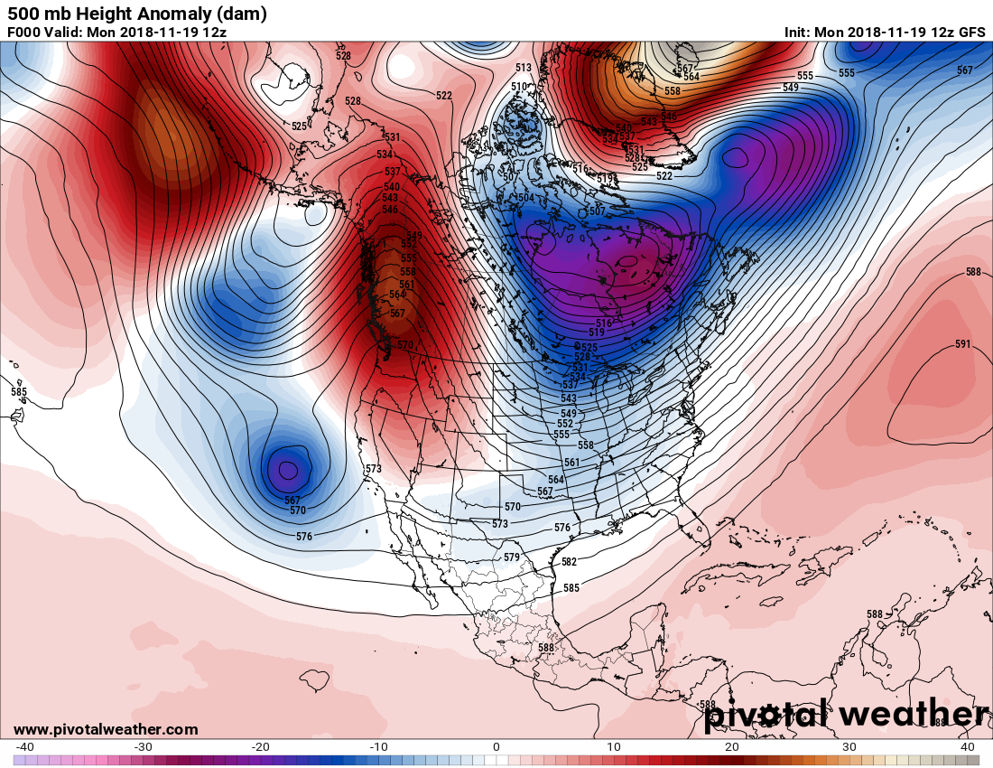
First we see again as of 11/19/2018 the most common temperature pattern that has occurred across the planet since 2013…that of a warm planet overall, with the largest cold pocket anomaly residing over eastern North America:

Notice the warmth stretching from Scandinavia westward to Greenland. This is an indication of a strong negative North Atlantic Oscillation, which usually leads to very cold weather east of the Rockies in the United States. Here is the 500 millibar pattern corresponding to the presented anomaly chart:
In North America we currently see a system approaching California, which will finally bring moisture relief to that state on Wednesday. Notice the ridge over Greenland, which in met speak will be a “block” locking in that cold vortex currently over Hudson Bay. Honestly, there is nothing really unusual, meteorologically, with this pattern, which usually leads to a colder than average December for the CONUS, but when one considers what is happening currently in Europe, climate change does come into play:
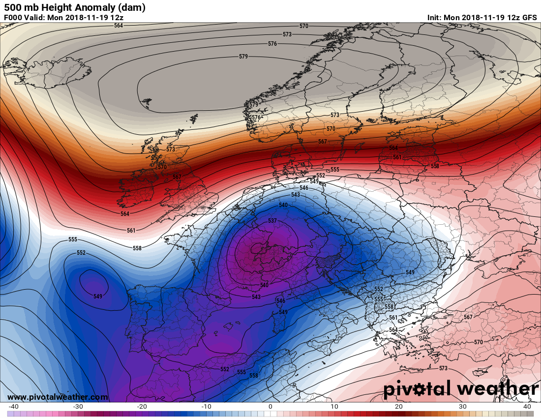
Wow! Anomalies over Scandinavia are nearly off the scale. I don’t often see 500 millibar heights this high over Scandinavia even during summer. Once again we see another “warm bubble” that has gotten lodged over the Arctic that is becoming more common as sea ice thaws and global warmth overall warps the jet. The Scandinavian ridge is feeding into the Greenland ridge strengthening the dipole configuration over North America…all are connected. On the above Pivotal chart a cold pocket is trapped south of the Scandinavian ridge producing cold wet and snowy weather in Europe.
Intense kink in the polar jet stream and warm in Greenland! https://t.co/UlB6BvUt14 pic.twitter.com/fN8f8uCZk6
— Aarne Granlund (@AarneClimate) November 17, 2018
The high amplitude meridonal jet stream flow we are now beginning to see more frequently is both a predicted effect of #ClimateChange and a factor influencing extreme weather events, including the current #CaliforniaFires h/t @MichaelEMann pic.twitter.com/ZMT34XnBQQ
— Randall Gates (@rgatess) November 11, 2018
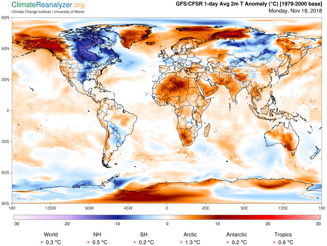
Looking at this anomaly chart again, it’s almost as if the last vestiges of predominantly cold weather on the planet are now confined to North America, climatologically. I’ve seen this broken record play over and over again this decade. Could global warming temporarily lead to North American cooling due to strengthening of the dipole going into the 2020s? We will see:
In any case the Northeast will be the first region of the country to see bitterly cold conditions going into Thanksgiving. You can see low thickness isallobars depicted on this Tropical Tidbits graphic valid for Thanksgiving in the Northeast:
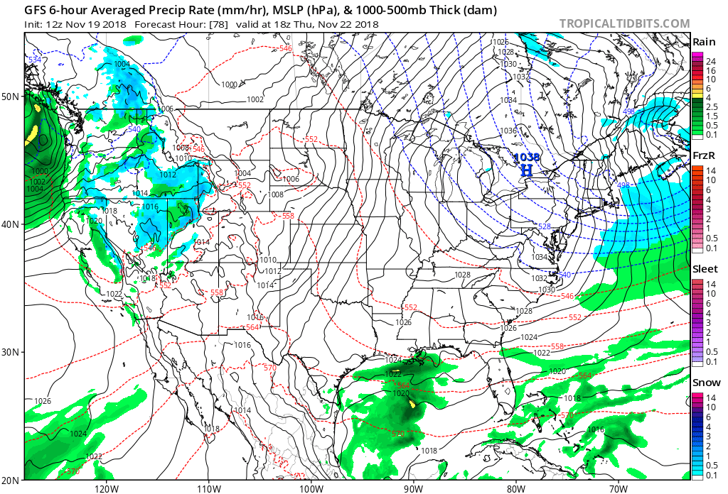
A 1038 millibar arctic high will be moving into the region while the West sees some relief. We probably will see many cold “ET” record reports coming from the Northeast through the weekend. Here we see some indications, some that are occurring as early as today:
You know it's a cold November (especially in our warming climate) when Caribou, Maine, has the earliest 0°F reading it's ever recorded. https://t.co/Q0qBlWB3Yg
— Bob Henson (@bhensonweather) November 19, 2018
Another way to look at the cold on #ThanksgivingDay, forecast departure from normal low temperatures. #frigid #nywx #nhwx #mawx #mewx pic.twitter.com/aPhtcoUAY6
— Tom Niziol (@TomNiziol) November 19, 2018
How brave are you? https://t.co/PIdzJ7OdmF
— Mike Bettes (@mikebettes) November 19, 2018
It is going to be a very chilly Thanksgiving Holiday for most of the Eastern US. pic.twitter.com/zB37uqCQ8d
— NWS Eastern Region (@NWSEastern) November 19, 2018
In the wake of the system brining relief to California, which will move through the CONUS into the Northeast, frigid air will be pouring into the Midwest headed towards the mid-South:

We’ll by watching for another nor’easter by next Monday or Tuesday, partially as a result of the system now approaching the West Coast. As I used to write in my discussions while employed at The Weather Channel, “models are sketchy this far out,” so there are lots of details to be ironed out. We probably will see a cold period from late November into December, but just how frigid? Stay tuned.
……………………………………………………………………………………………
Here is some more weather and climate news from Monday:
"We are on path to self-destruction, & yet there is nothing inevitable about our fate." The #climate news…isn't good. Those saying otherwise aren't being honest. But just as destructive is notion of distinct threshold beyond which all hope is lost. https://t.co/NgccSk03UV
— Daniel Swain (@Weather_West) November 19, 2018
The Arctic is warming faster than any other region of the planet because of Anthropogenic greenhouse gas emissions. Here’s some reasons why.https://t.co/a384JjlZPS via @physorg_com
— Randall Gates (@rgatess) November 19, 2018
‘Like a Terror Movie’: How Climate Change Will Cause More Simultaneous Disasters | Must-read article by John Schwartz (@jswatz) of The @NYTimes on latest climate change impact research: https://t.co/zm0G7ePwZ3
— Michael E. Mann (@MichaelEMann) November 19, 2018
annnnnnd it's gone. The sun just set in Utqiaġvik (Barrow), Alaska, at 1:44 p.m. AKST. It will rise again at 1:26 p.m. on January 22nd (65 days from today). @AlaskaWx pic.twitter.com/fcDAhcYGMi
— Brian Brettschneider (@Climatologist49) November 18, 2018
First wave of rain arrives Wednesday morning. 2nd wave arrives Thursday afternoon. #CAwx pic.twitter.com/EOmmM04LKh
— Rob Elvington (@RobElvington) November 19, 2018
A 50-degree day in February isn't the same as a 50-degree day in October. Your body just hasn't adjusted to the cold yet.
— The New York Times (@nytimes) November 13, 2018
These are some of the environmental crusaders that have RL Miller, founder of @ClimateHawkVote, "incredibly optimistic" about the next Congress.https://t.co/I0vf0fMVl9
— InsideClimate News (@insideclimate) November 20, 2018
Climate scientists live in a world that’s caught between where we are and where we need to be — a barometer for how thinking, feeling people with full knowledge of our society’s existential problem are coping when we’ve got 12 years to remake everything.https://t.co/HU9AeroHVa
— Eric Holthaus (@EricHolthaus) November 19, 2018
(As usual, this will be a fluid post in which more information gets added during the day as it crosses my radar, crediting all who have put it on-line. Items will be archived on this site for posterity.)
(If you like these posts and my work please contribute via the PayPal widget, which has recently been added to this site. Thanks in advance for any support.)
The Climate Guy