Wednesday evening update…
Dear diary. A mini heat wave is underway in the South, Mid-Atlantic and southern portions of the Midwest. St. Louis was very hot with a max of 103F. Their record high was 110F set in 1954, so during what is climatologically the hottest time of the year, it takes quite the heat wave to set records. I expect that only a few records will be set from coast to coast the next few days.
 Wednesday July 12th…
Dear diary. Operational models and ensembles are trending towards a big upper ridge over the nation’s heartland later this month leading to the highest temperatures, so far, of the season across the Plains and South. Today let’s take that logical conclusion step by step.
- First we need to see that model ensembles have come into agreement. Check.
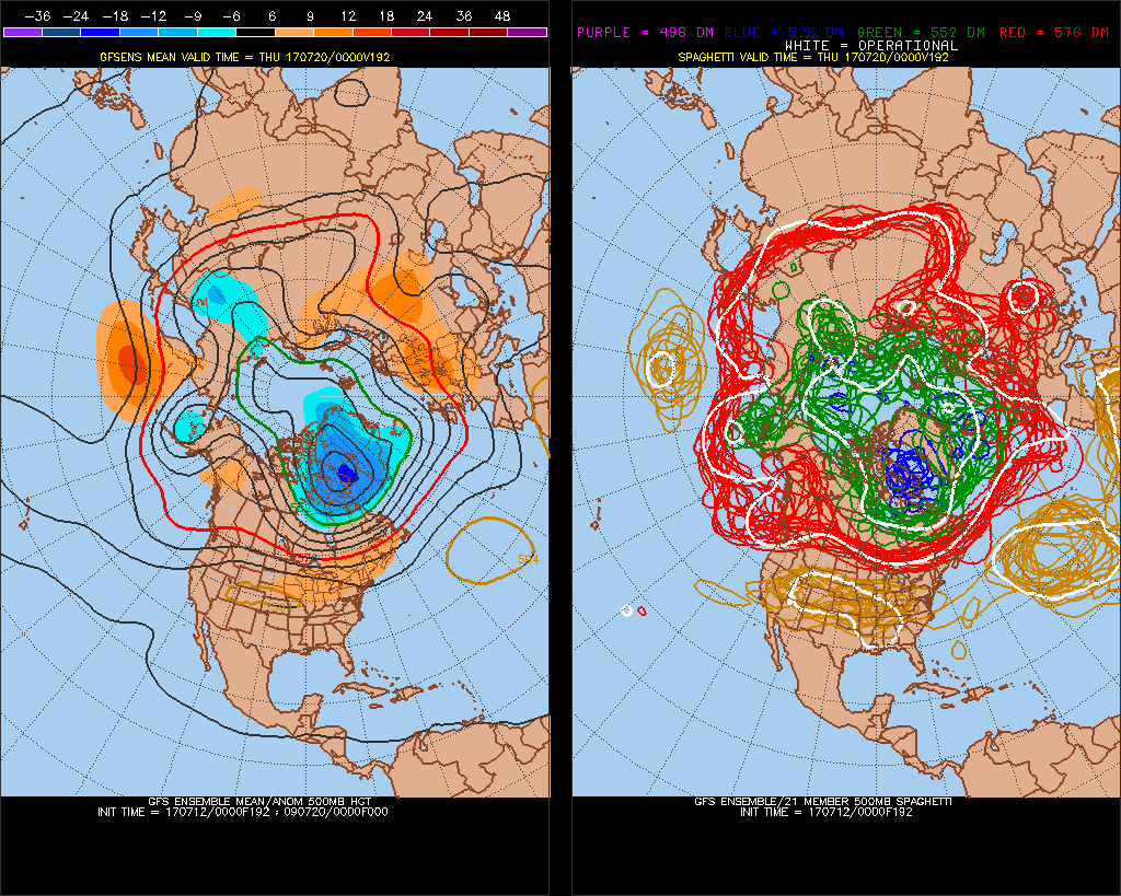
Note that this chart is valid for July 19th (00Z on the 20th). Before that time in little over a week from now an upper ridge will briefly be over the Southeast through tomorrow then build back towards the West:
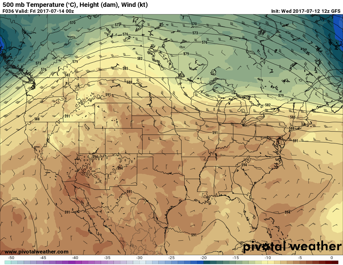
While the ridge is near the Southeast it will get hotter, but most maxes will be well below record levels. Note that Washington D.C. will be in the mid-upper 90s tomorrow:
2. Of course we need to make sure that the forecast trend comes before 240 hour “fantasy” models, and what we see here, operationally, that the following chart meets that rule of thumb criteria:
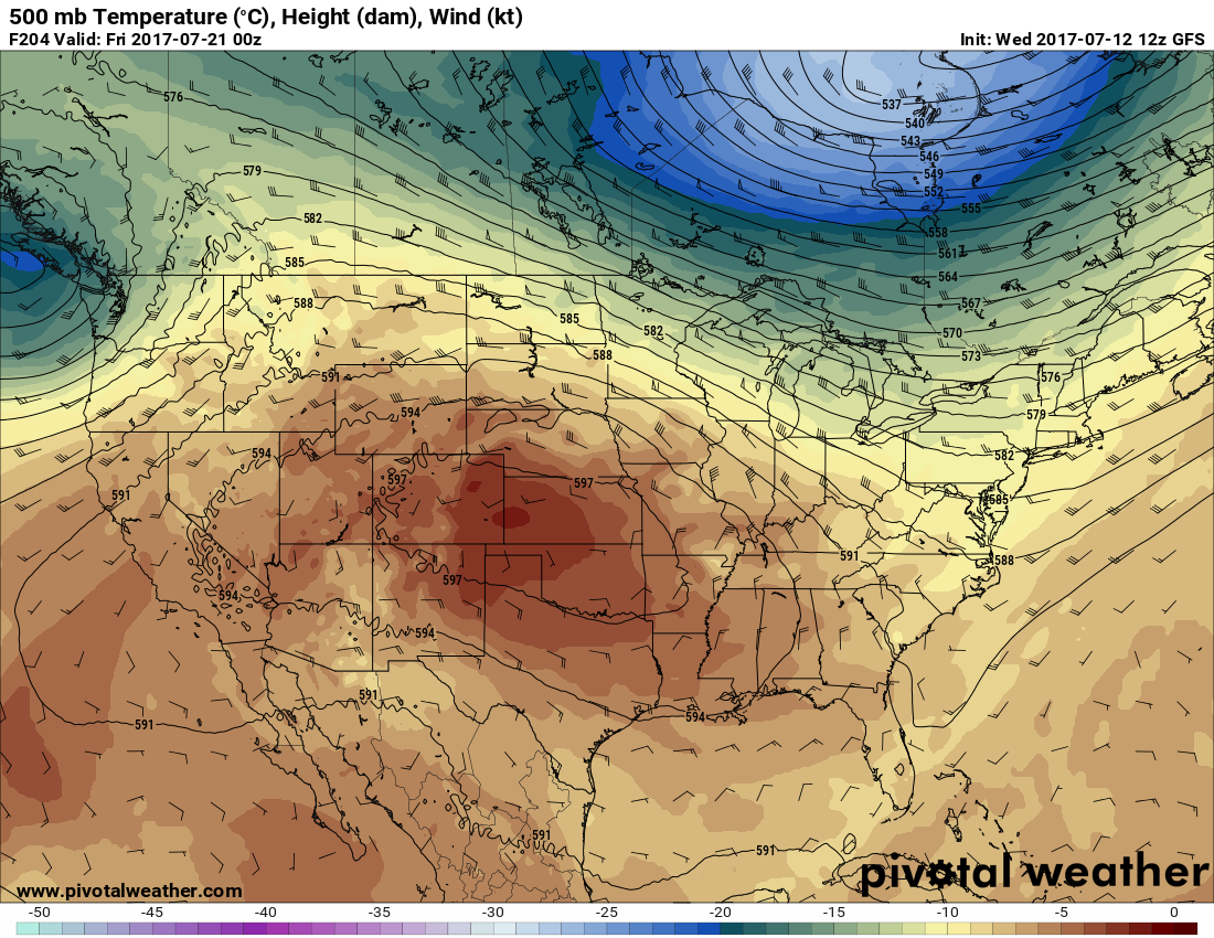
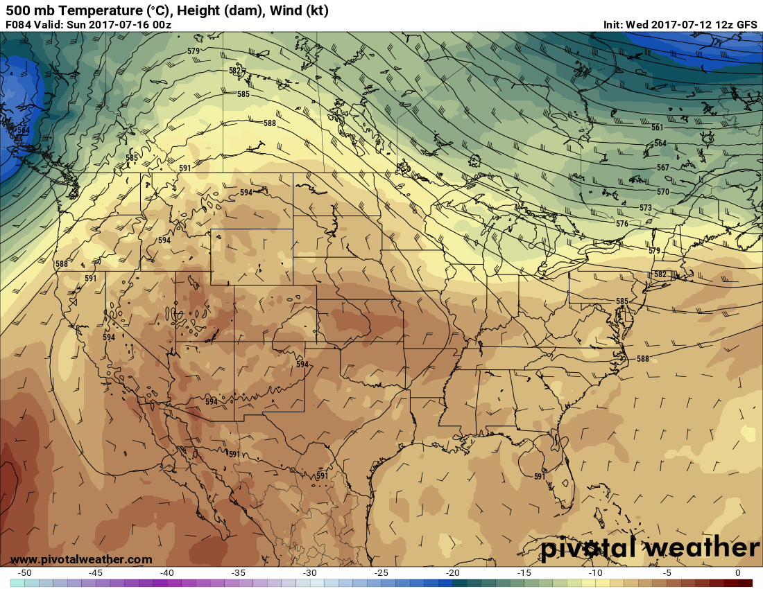
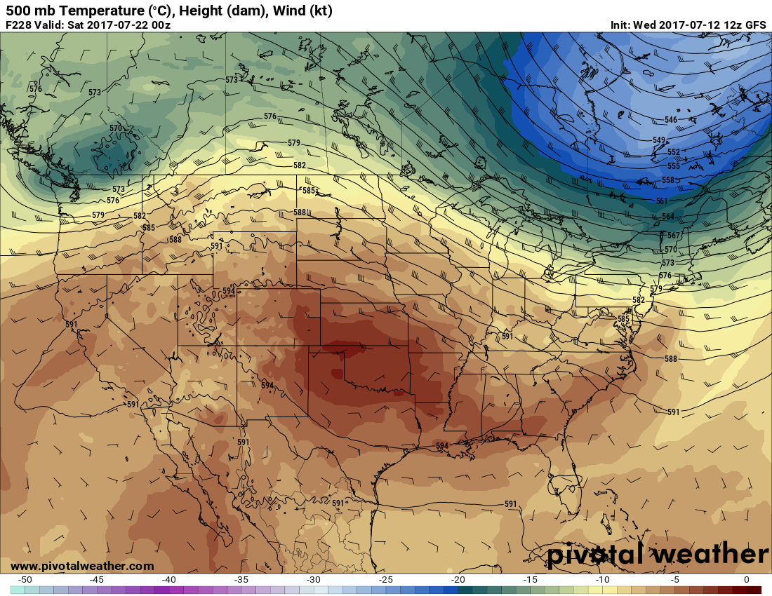
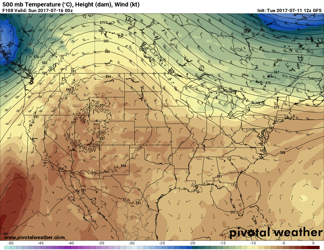
By July 20th the prognosis is that a system moving into the Pacific Northwest will nudge the western ridge into the central Plains. Forecast heights above 597 decameters in the nation’s heartland are not unprecedented, but rare. The ridge may progress further east into the Southeast by the 22nd:
I’ll stress here that the exact placement and strength of the heat ridge is in question. Good news for the West here. If this forecast scenario takes place, monsoon storms will be more widespread over the West, and extreme heat will abate. Why Phoenix may fail to reach 100F, for instance. I did note that as we go out past 240 hours into fantasy solutions the GFS strengthens the ridge over the Southeast keeping a heat wave there for a few days. It’s too early to tell if this 4th heat wave of the season will produce a lot of record temperatures. Stay tuned.
I’ll be adding to this post with updates later today.
To see all 2017 Heat Diary entries click:
https://guyonclimate.com/category/heatdiary2017/
The Climate Guy
Tuesday Evening Updates… Dear diary. I’ve got some good news to report for a change. Las Vegas finally broke a long streak of 105F+ days on the 10th:
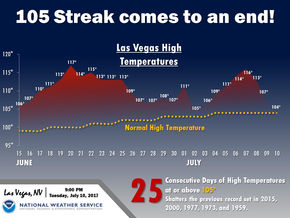
Let’s just write that in the weather department, Vegas was rolling a lot of snake eyes in the last month.😉
Tomorrow the warming trend will continue south of an upper Midwest front across much of the East. Washington D.C. will be flirting with 100F:
Unfortunately the West’s cooling trend will end at most locations on Wednesday.
Speaking of the West there is news coming out of Alaska. A heat wave will produce 90F readings as far north as the Arctic Ocean this week according to this Grist article (and you may also like the main imbedded article about electric car powertrains). I’ll credit the photo of Alaskan wildfires also to the article. Is this the picture of the ravages of climate change?
https://grist.org/briefly/this-satellite-image-captures-our-smoky-climate-changed-world/

“The NASA Terra image of Alaska shows a dramatic juxtaposition of retreating Beaufort Sea Ice to the north and smoke from wildfires in the high Arctic tundra spreading hundreds of miles into Canada.”
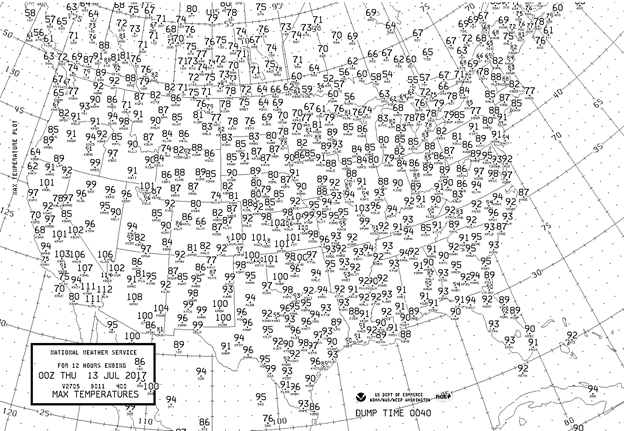
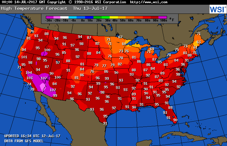
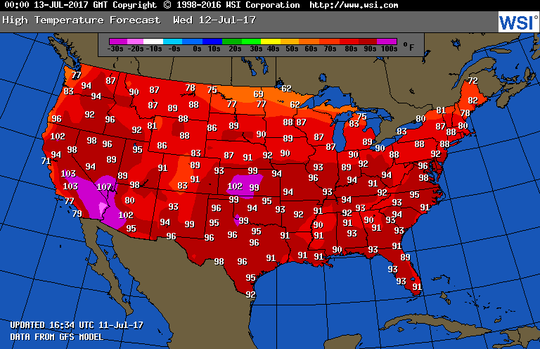
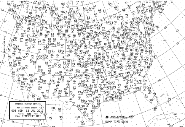
Here are the maxes for Tuesday 7/11/2017:
Hest continues from Kansas into Missouri in part due to heat indexes above 105F. The heat that was in eastern Montana and North Dakota on Monday has slipped unto South Dakota. For the second consecutive day Salt Lake City was under 100F topping out at 96F today.
The Climate Guy
Tuesday July 11th…
Dear diary. The massive heat dome, or ridge, that has plagued the West has broken down and moved off to the eastern U.S. The West, while reaming hot with above average temperatures, is at least getting a break from extreme heat. Also, monsoon storms should bring much needed rain to a few. Some of these storms will be classified as haboobs. Haboobs are one of my favorite terms in the meteorological lexicon. These are large, mainly dry, dusty storms that develop from the southwestern monsoon, that are beautiful to photograph from a distance. They can cause blinding dust storms, and can cause havoc in cities such as Tucson and Phoenix.
Here is a great picture of a haboob taken near Phoenix in 2016:

The 500 Mb pattern looks like this today:
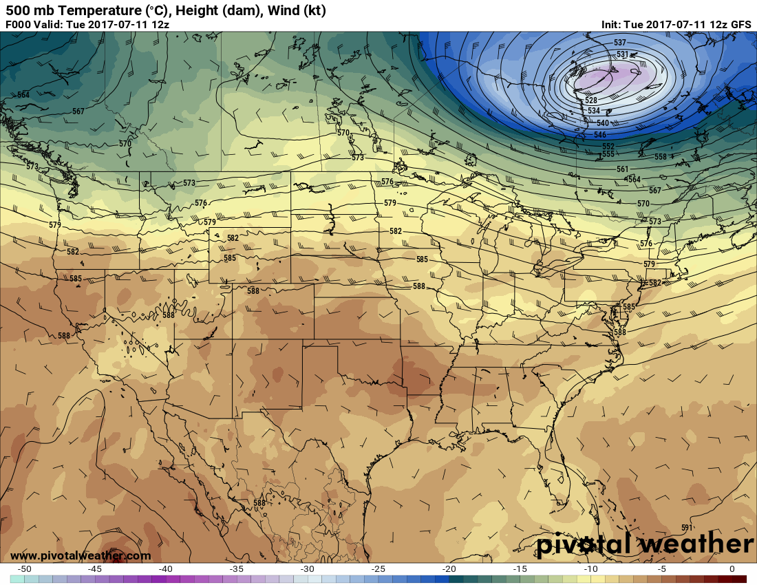
Western 500 Mb heights are the lowest in weeks, however they have risen considerably in the East. Portions of the Mid-Atlantic area will see their hottest temperatures, so far, this season with some maxes getting unto the upper 90’s to near 100.
The western relief will be brief, however, as the ridge retrogrades back to the west then restrengthens by the 14th and 15th centered on Utah once more. I’m sure that the added heat will hamper fire fighting efforts in the West in a few days, unfortunately.
Let’s once more hone in on Salt Lake City’s temperature trend. Here is the latest MRF MOS GUIDANCE:
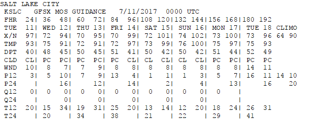
I would not be surprised if Salt Lake City got above guidance numbers.
I’ll be adding to this post with updates later today.
To see all 2017 Heat Diary entries click:
https://guyonclimate.com/category/heatdiary2017/
The Climate Guy