The main purpose of this ongoing blog will be to track planetary extreme, or record temperatures related to climate change. Any reports I see of ETs will be listed below the main topic of the day. I’ll refer to extreme or record temperatures as ETs (not extraterrestrials).😉
Main Topic: Update on Heatwave British Petroleum
Dear Diary. One of the biggest of the many elephants in the climate room is what I’ve dubbed historical Category Four Heatwave British Petroleum. Now we will see how many problems this heat episode causes and, God forbid, deaths across the U.S. South. I’ll have Heatwave BP and a new heatwave developing in the West as my main topics the next several days.
Here we the state of Heatwave BP yesterday afternoon:
Today the situation is worse in the south-central states is worse:
And smoke from Canadian wildfires was bad too:
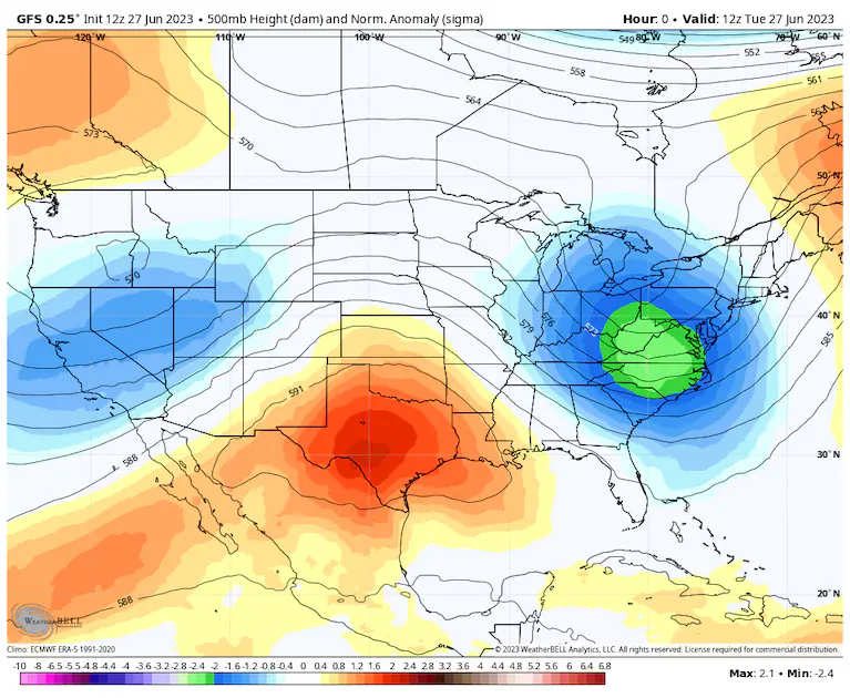
The culprit behind this stagnant weather pattern is, of course, a heat dome. This one does not look that impressive, but the fact that it is not moving lets record heat build over one area day after day after day:

Here is the latest summary and outlook on Heatwave BP from my friend Matthew Cappucci writing for the Washington Post:
Extreme heatwave continues in Texas, expands across south central U.S. – The Washington Post
Extreme Texas heat wave to swell across southern, central U.S.
Heat topping 110 degrees will be common across the Lone Star State.

June 27, 2023 at 12:55 p.m. EDT

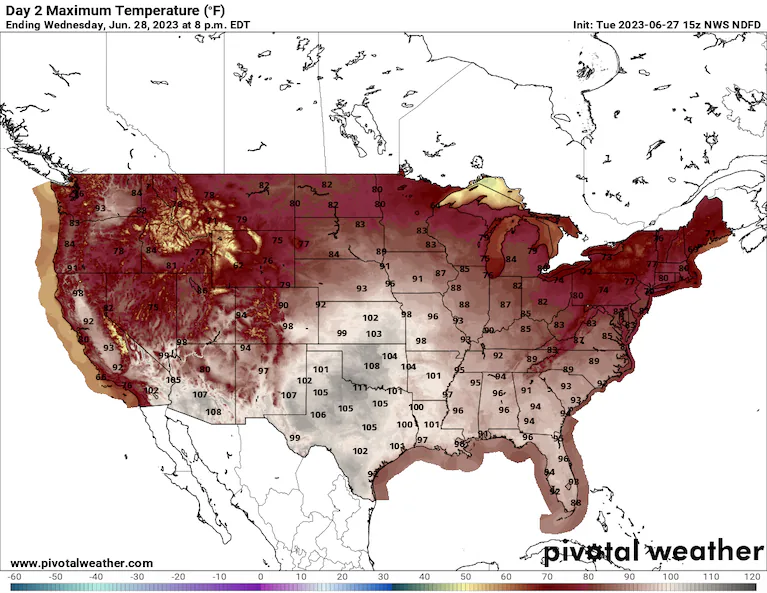
Predicted high temperatures on Wednesday as forecast by the National Weather Service. (WeatherBell)
Triple-digit temperatures are a staple of summertime in Texas, but readings are running extra high so far this June. An exceptional heat wave is continuing to bake the Lone Star State, and it will expand in the coming days across much of the southern Great Plains, the Deep South and the Lower Mississippi Valley.
Heat advisories stretch from northern Florida to southern New Mexico, and excessive-heat warnings have been issued for much of Texas and parts of New Mexico and Arizona and along the Gulf Coasts of Louisiana, Mississippi and Alabama. New Orleans is included in the zone of greatest heat risk, with actual air temperatures around 100 degrees and humidity that will push heat indexes to 115 degrees.
Texas heat wave is so bad, meteorologists are apologizing for it
Excessive-heat watches, meanwhile, have been posted for the lower Mississippi Valley and include Memphis and Nashville; Huntsville and Birmingham, Ala.; Jackson, Miss., Little Rock; and Poplar Bluff, Mo.
How bad is heat risk near you?
 We’re tracking dangerous heat waves across the United States daily. Look up your city to see extreme heat risks near you. (The Washington Post)
“Extreme heat and humidity will significantly increase the potential for heat related illnesses,” cautioned the National Weather Service, “particularly for those working or participating in outdoor activities.”
The heat will relent somewhat into early next week for portions of the Southeast and Mid-South, but there is no immediate end in sight for Texas, where blistering and brutal conditions look to continue.
What is behind the heat

A heat dome lingers over Texas. (WeatherBell)
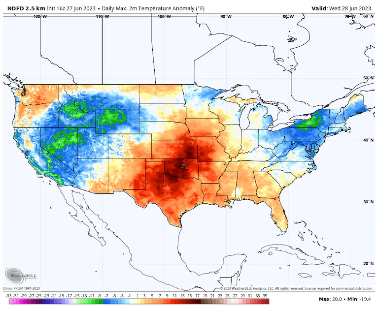
Instigating the heat has been a stagnant ridge of high pressure parked over Texas. That “heat dome” brought hot, sinking air while deflecting storm systems around it to the north. The uninterrupted sunshine helped temperatures to spike by 8 degrees to 18 degrees above average.
What set this heat dome apart was not just its magnitude, however. Its stubbornness and longevity also have been big factors in its anomalous impacts. The city of Del Rio, Tex., hit 115 degrees June 21, for instance, and could reach a 10th consecutive day of tying or breaking record highs.
Even more noteworthy have been the overnight lows in the city, which haven’t dipped below 80 degrees since the morning of June 15. The average low in Del Rio during mid- to late June is 74 degrees, but increased humidity — the same that is contributing to hazardous daytime heat indexes — is generating warm overnight lows. That is especially problematic, because high nighttime temperatures prevent the body from achieving its needed nocturnal cool-down.
Soupy humidity will continue to waft north out of the Gulf of Mexico. Dallas already logged an 80-degree dew point June 15, tying its record; this mark has been reached only five times since 1947. That oppressive sultriness will overlap with the heat until the overarching weather pattern finally breaks up late in the weekend.

High temperature anomalies as predicted by the National Weather Service. (WeatherBell)
How hot it will become
The heat is also about to expand into the Mississippi Valley. So, although Texas will experience continued highs of between 100 degrees for places including Houston, San Antonio and Austin and lower 100s in Dallas and as high as 110 degrees in San Angelo, the worst is soon to spread north and east.
Oklahoma City will experience a brief flare-up of heat. Highs are likely to touch 105 degrees Tuesday and settle back into the lower 100s Wednesday. That would tie the record of 105 set in 1980.
New Orleans may not crack 100 degrees for the actual air temperature, but tropical rainforest-like dew points in the upper 70s to around 80 will mean that every cubic meter of air will be holding about 1.5 tablespoons of moisture. That will prevent sweat from evaporating off the human body, inhibiting one’s ability to cool oneself and exacerbating heat stress. Heat indexes will range from 113 degrees to 117 degrees through at least the end of the week.
Jackson, Miss., will face highs in the upper 90s to around 100 degrees, with this level of heat likely to persist into Friday. For Memphis, triple-digit highs — and heat indexes above 110 degrees — are likely Thursday, Friday and Saturday. And Nashville also may hit 100 each day in the same window, with similarly dangerous heat indexes.
The heat should finally begin to subside from Sunday as the parent heat dome flattens.

By Matthew Cappucci Matthew Cappucci is a meteorologist for Capital Weather Gang. He earned a B.A. in atmospheric sciences from Harvard University in 2019, and has contributed to The Washington Post since he was 18. He is an avid storm chaser and adventurer, and covers all types of weather, climate science, and astronomy. Twitter
Here are some “ET’s” recorded from around the planet the last couple of days, their consequences, and some extreme temperature outlooks, as well as any extreme precipitation reports:
Here is more climate and weather news from Wednesday:
(As usual, this will be a fluid post in which more information gets added during the day as it crosses my radar, crediting all who have put it on-line. Items will be archived on this site for posterity. In most instances click on the pictures of each tweet to see each article. The most noteworthy items will be listed first.)
Today’s News on Sustainable Energy:
https://twitter.com/BrianMcHugh2011/status/1674046888230748161?s=20