I’m going to quote myself from spring, summer, and fall when I attempted to make seasonal forecasts: “Forecasting for a season is perhaps the most difficult, and as the public knows, most unreliable product put out by any group be it those, for example, from NOAA or people putting together The Old Farmers Almanac. If farmers, power companies, construction companies, those doing a lot of outdoor work, and even health professionals had a good heads up on weather and temperature trends over the course of the next three months literally billions of dollars could be saved, and perhaps some lives as well. Unfortunately, model reliability and long range forecast skill sets are not up to par with public expectations when it comes to seasonal outlooks. Weather forecasts for the next week have gotten remarkably better over the last decade, and there has been improvement in long range outlooks, but current crystal ball methods we have for forecasting seasons leave much to be desired. (Admittedly though, the ones for this year have been quite good.) Knowing the limitations of seasonal forecasting, in this post I will attempt to make a broad forecast for the winter of 2017/2018 in the United States keeping in mind trends due to carbon pollution. By no means am I a skilled seasonal forecaster, but I will give this my best shot knowing that there is a need by the public craving to know what is in store this coming winter, at least temperature wise.😊”
My fall forecast wasn’t too shabby predicting the nationally (lower 48) average ranking of temperatures to be well above average:
https://guyonclimate.com/2017/09/12/forecasting-a-warm-fall-2017/
The CONUS, or lower 48 states, saw relatively mild temperatures this fall and a ranking of 10th warmest since 1895, as would be expected as global temperatures ramp up due to carbon pollution.
As far as records go, we didn’t see a dreaded month of a 10 to 1 or more ratio of more daily high maxes than low minimums in the NCEI database this fall (in bold on the chart), but that “Streak” of consecutive months of DHMX than DLMN continued from November 2014 into November of this year (data through 11/20/17):

The above chart is a huge clue as to what to forecast for in the months ahead for a seasonal forecast showing a steady trend of warmth. Now we need to ask and answer a series of questions to make a decent seasonal forecast:
Question One. Is there any indication of a temporary planetary cool down? Answer: no, so we would expect the trend from the records chart to continue.
Question Two. What do sea surface temperature averages look like around North America? Here is the answer:
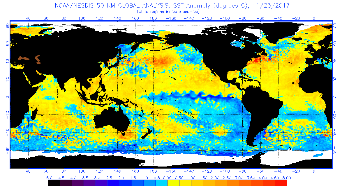
Hudson Bay and the northeast Pacific have cooled, but most waters around North America remain warmer than average. The much touted La Niña is very apparent west of South America. I have no reason to disagree with prognoses forecasting a La Niña pattern in association with temperatures this winter:

Yes there will be cold snaps from time to time across just about every corner of the CONUS, but will they be cold enough to produce widespread below average temperatures for the winter season except for perhaps the northern Plains and Pacific Northwest? Probably not.
Question Three. Will there be a strong Hudson Bay low or vortex ushering in cold air masses into the U.S. particularly as we go into December? Looking at ensembles the thing will initially be weak and displaced to the north and west of the Bay:

What’s interesting here is that typically when seeing a strong negative North Atlantic Oscillation (the positive anomalies over and around Greenland) a cold trough usually develops over the eastern U.S. This won’t be the case during the first week of December, though.
Question Four. How much snow cover is over the CONUS in late November. The answer… not much:

Of course, snow cover helps to radiate incoming solar energy out to space thereby locking in cold air. Important point: I’m discounting the idea that increased Siberian snow this fall could lead to a cold winter in the U.S. Now a strong Hudson Bay vortex could funnel in cold air from Siberia and Alaska, but the orientation of tea leaves I’m seeing at this point at the bottom of the climate cup don’t show that.
Here are NCEI rankings for every season for this decade:

A ranking of 122 would be the warmest ranking in record since 1895 in the CONUS. *Note that the last two winters have been very warm with the winter of 2015/2016 warmest on record mainly due to the influence of a near record strong El Nino.* I’ll fill in the fall 2017 blank around DEC 8th. We are way overdue to see an average or below average season across the U.S. Carbon pollution is definitely making below average seasons more rare. I’m going to guess that the winter 2017/2018 ranking will fall around 115 +or – 5, with higher than average confidence. This winter will probably be slightly cooler than the last two, though. Don’t forget, as mild as the winter is forecast, there should be winter storms from time to time at least across the nation’s northern tier of states for all you snow lovers. Given all of the warm factors shown in this post, though, it should be a mild winter for many sections of the country. Let’s see if this forecast will be a bust.😅
You can follow how the winter season is going and pick up $100 to boot by playing my Climate Lottery game here:
https://guyonclimate.com/the-climate-lottery/
Have a great winter!
The Climate Guy