Saturday December 9th… Dear Diary. Here is today’s climate change related topic:
Thawing Permafrost is Already Damaging Arctic Towns and Infrastructure:
The following USA article tells the threat from climate change to towns built on permafrost:
The only way to adapt to an increasingly warm world will be for residents to either relocate or rebuild on non-permafrost covered ground.
“Melting permafrost and higher temperatures have caused havoc here in recent years, triggering sometimes deadly avalanches on the steep mountains that flank the town. Houses have been destroyed, while roads and some areas have been closed or declared unsafe to live because of the risk.”
Here is the location of Longyearbyen from the article:

It’s been a few days since the late November/early December warm wave ended, but record reports are still coming in for that period in the NCEI database. It’s time for a “record score board” update:

The number 117 has been added to the chart representing the fact that NOV 2017 was the 7th warmest November on record on a scale from 1 to 123 since 1895. December 2017 has gotten off to a warm start only cooling off in the eastern and central states after the 6th due to what The Weather Channel is calling Winter Storm Benji. The ratio of DRHMX to DRLMN so far this month is a whopping 74 to 1, but I guarantee that due to cold outbreaks in the East it won’t be so high by the time December ends. Nevertheless, as Bob Henson noted on his post on Weather Underground yesterday, the air mass in the wake of Benji just isn’t that cold by historic standards. Here are mins valid for Sunday:

While cold and slightly below average in the South, I would not expect any records to fall tomorrow. Perhaps we will see some record cold in portions of the Northeast by the middle of next week. More record warmth could occur in portions of the West.
Oh, and P.S. on all that southern snow from Benji:
What happened w/ overperforming overrunning #snow event? Possible culprit is poorly forecasted SE ridge off EUS, shifting s/w inland & more amped. Warm SSTAs may have aided ridge amplification via LHR offshore on bc zone. Result: A consistent +500 geo height trend in GEFS & GFS. pic.twitter.com/cWFlYw6Vcz
— Philippe Papin (@pppapin) December 9, 2017
Here are some snow amounts from my neck of the woods that were not forecast too well:
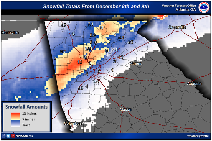
Enjoy more snow information from yesterday’s diary.
Here are a couple of records from major cities for today:
 NWS Los AngelesVerified account @NWSLosAngeles
I may add more relevant information should it cross my radar later today.
The Climate Guy
Friday December 8th… Dear Diary. Here is today’s climate change related topic:
Lower latitude snow due to climate change not so rare?
The Climate Guy is going to take a snow day today away from blogging on record heat and fire.😊 Ladies and gents heavy snow is falling across my home town of Atlanta GA and on a relatively early date…December 8th. Today we have a widespread wet snowstorm in southern tier of states that was hinted at by meteorology models up to 72 hours ago, but the event was way under forecast. Here is an eye popping image from Corpus Christi TX showing several inches of snow on palm trees (Image Credit: Briana Whitey @Briana Whitney)

Don’t forget that just about three months ago Corpus Christi was dealing with Hurricane Harvey.
Yep this is the Texas A@M Aggies stadium!
— Texas A&M Football (@AggieFootball) December 8, 2017
Here’s a shot from Jackson MS where 4-5″ fell (Image Credit Daniel Lamb):
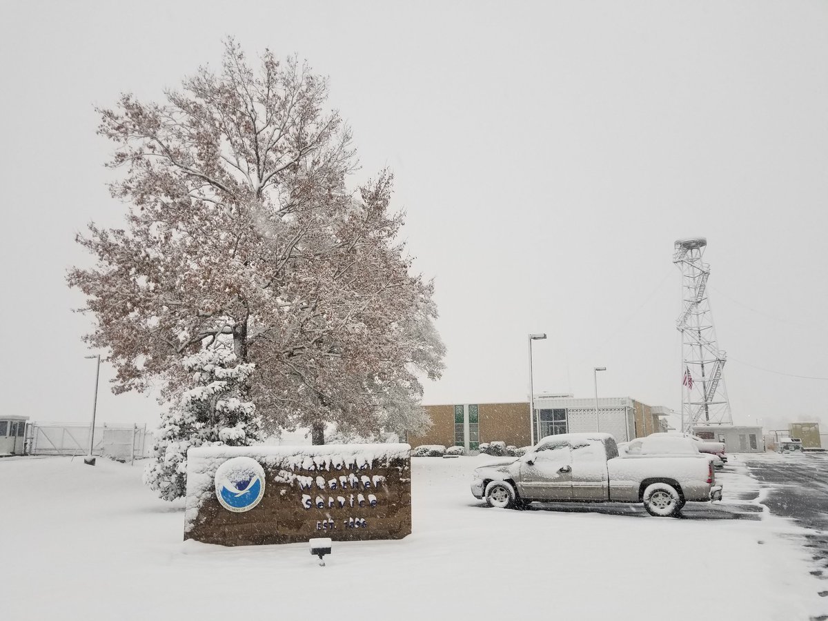
Here are some reports of how anomalous this winter event is from this morning from TWC’s Greg Diamond:

I noticed that the met models were having trouble forecasting the geopotential 500 millibar pattern over Texas. Here is what verified over North America:

I’m going to call this event the “Dipolesnow.”😀 Notice that there is a lobe around the 552 decameter line trying to pinch off around Texas. This system turned winds aloft towards the Southwest allowing for copious amounts of moisture to overrun a polar front leading to widespread heavy snow…much under forecast since the thing wasn’t supposed to decouple from the main jet that dug southward into the Midwest.
So what on Earth does snow and cold weather have to do with global warming? Off hand one would say that since this snowy event has occurred nothing is really wrong with the climate system, right? Well..wrong. This week we have seen what Daniel Swain has uncovered in association with the current Dipole system as also shown on the above Pivatol Weather cart. Stu Ostro and other meteorologists have notice since about the turn of the century more frequent “Rex Blocks”, or large cold pockets aloft, trapped south of increasingly high geopotential height ridges leading to recent snow storms from North Africa to southern China the last couple of decades. This snowstorm isn’t in association with a closed low over the South, but a cold trough forced far to the south due to the western ridge. Also, think of the entire cold vortex trapped south and west of Greenland as one giant Rex Block.
I can’t recall seeing a 585 decameter ridge over most of the West Coast in early December. As we know in science for every action there is an equal and opposite reaction until equilibrium is established. The atmosphere is trying to come into equilibrium over North America via Swain’s Dipole, thus the trough in the East has dug very far to the South in response to the mega ridge over the western U.S. and western Canada as noted by the red, orange and white colors on the chart. Eventually, according to Swain and other climate scientists, the Dipole will disappear sometime in later decades. We may see one giant ridge dominate North America every month if the year if carbon pollution remains unchecked, a prospect no one would want to deal with, trust me.
Also don’t forget that precipitation events, including snow, are getting heavier due to climate change. I can’t prove that we are seeing this effect for this system, but it’s something to keep in mind.
Here are some more meteorology dynamics in association with a heavy snow band affecting Atlanta and much of the mid-South:
Centered my #HRRR maps on #KATL to illustrate current overrunning snowfall event. #Rain/#Snow line along I-85 along bright banding axis. 700-hPa frontogenesis maintaining forcing for ascent for more precip along I-85 overnight. #ALwx, #GAwx, #SCwx
Link: https://t.co/PUugnIsJ3q pic.twitter.com/05dY9Ohqtq
— Philippe Papin (@pppapin) December 8, 2017
This weather is pure snow heaven on my side of town in Atlanta:
It is REALLY coming down here in Marietta, GA. The video doesn't do it justice.
I never thought this storm would produce snow like this here #forecastbusted #Benji pic.twitter.com/aKEtllrTQI
— Greg Diamond (@gdimeweather) December 8, 2017
From Chris Dolce of TWC near my residence: “Now up to 8” in northwest #Atlanta burbs near Acworth. I’ve lived in that ATL area 35 of my 40 years, pretty sure this is the most snow I’ve ever seen in a storm.” #gawx @NWSAtlanta

So everyone across the South enjoy your snow partially brought to you by an odd weather pattern induced by global warming. Even at my age I feel like a kid when there is a good snow.🤗
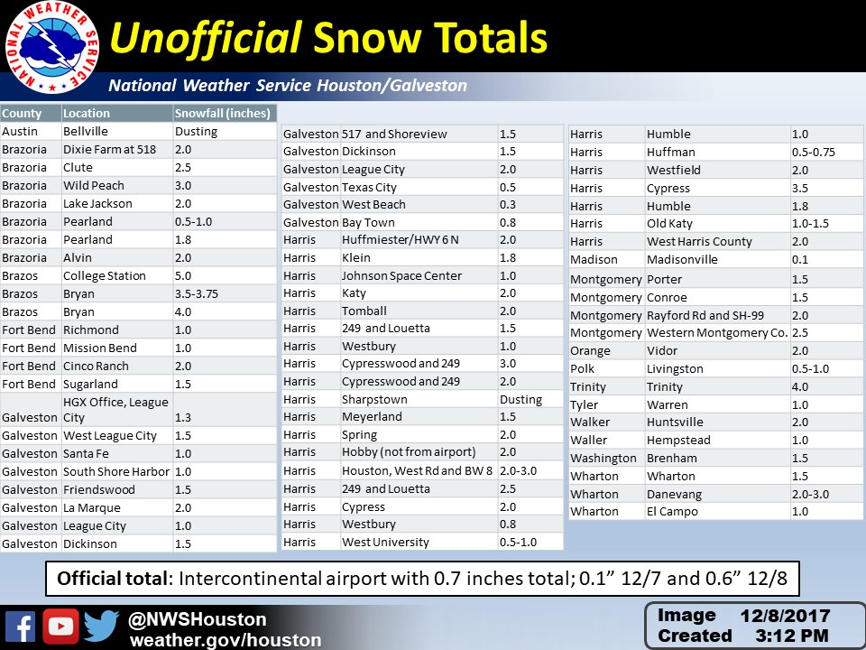
Here are some snow totals from the Houston area:
And yet more snow totals:

The mega ridge on that Pivatol weather chart extends all the way north to Alaska, so this is not too shocking, but is raising some eyebrows:
 Brian Brettschneider @Climatologist49
The Climate Guy
Thursday December 7th… Dear Diary. Here is today’s climate change related topic:
What’s the link between the California fires & climate change?
Here is a good summery from Inside Climate News in association with the current conflagration across California:
“An increasing body of research finds that the hot and dry conditions that created the California drought were brought on in part by human-caused warming.
Higher temperatures pull moisture out of soil and vegetation, leaving parched landscapes that can go up in flames with the slightest spark from a downed utility wire, backfiring car or embers from a campfire.
California’s average temperature has risen about 2 degrees Fahrenheit during the second half of the 20th century. Altogether this has led to more “fuel aridity”—drier tree canopies, grasses and brush that can burn.
“There’s a clear climate signal in these fires because of the drought conditions connected to climate change,” said Daniel Swain, a climate scientist at UCLA.”
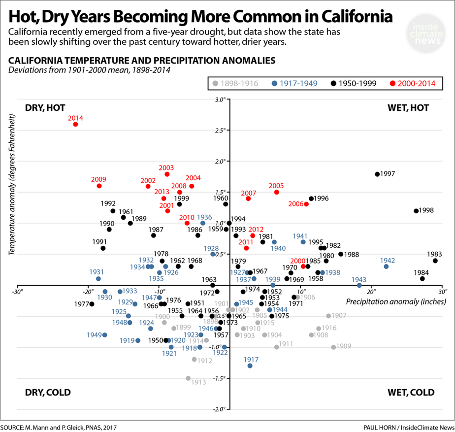
(Chart from the Inside Climate News article.)
Today instead of record temperatures let’s report some peak wind gusts, which fanned more flames this morning:
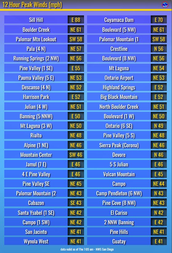
Still Hill reached 88 mph! There was a little good news in that winds did not reach forecast values in a few areas from Daniel Swain:
 Daniel SwainVerified account @Weather_West
 NWS Los AngelesVerified account @NWSLosAngeles
