Friday February 23rd… Dear Diary. The main purpose of this ongoing post will be to track United States extreme or record temperatures related to climate change. Any reports I see of ETs will be listed below the main topic of the day. I’ll refer to extreme temperatures as ETs (not extraterrestrials)😊. Here is today’s climate change related topic: February Flood and Warm Wave of 2018 Day Four
(If you like these posts and my work please contribute via the PayPal widget, which has recently been added to this site. Since I am a paraplegic I can definitely use any funds for medical expenses. Thanks in advance for any support.)
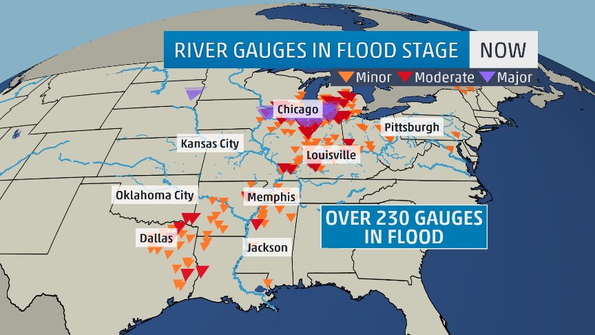
Unfortunately met models were correct forecasting rain along and near our stalled front to train over the same flooded areas. Some places from Arkansas eastward though the Ohio Valley will indeed see a once in a hundred year flooding event. Here is what I am seeing today from TWC’s Greg Diamond:

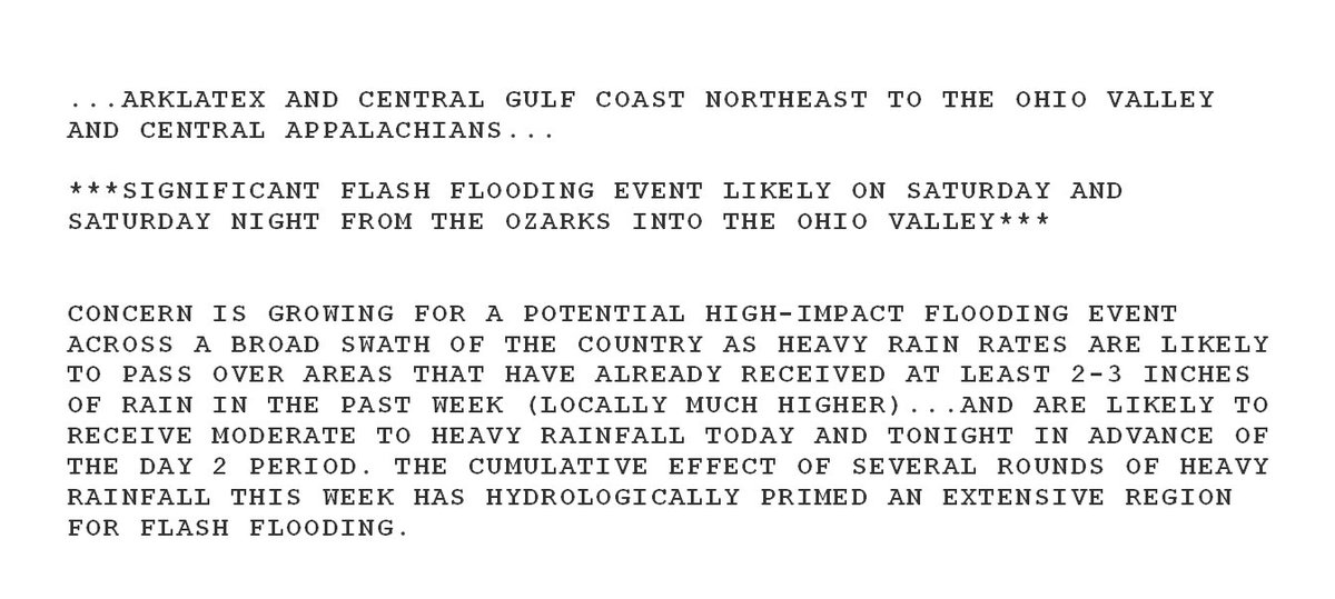
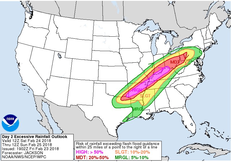
Quote below taken from @NWSWPC

Wow! Dr. Jeff Masters has written another great, intricate piece on the flooding:
https://www.wunderground.com/cat6/record-atmospheric-moisture-feeding-central-us-flooding
Yesterday I presented an excerpt of Dr. Master’s post on record 500 mb geopotential heights. Today I’ll show his record precipitable water data:
Record atmospheric moisture fed the flood
Accompanying the exceptional February warmth this week were record levels of February moisture, as a flow of unusually moist air rode northwards from the Gulf of Mexico, where water temperatures were about 1.0°C (1.8°F) above average. Meteorologists use a term called “precipitable water” to discuss how much water vapor is in the atmosphere. Precipitable water is defined as how much rain would fall on the ground if one took a vertical slice of the atmosphere above a given location and condensed all the water vapor into rain. Precipitable water levels tend to be higher when the temperature is warmer, since warm air holds more water vapor. This week, an extraordinarily large number of upper air balloon soundings set all-time records for February moisture. There are 73 radiosonde stations in the contiguous U.S. that take routine measurements twice per day, and six of them set all-time February precipitable water records this week; four of these stations broke their previous February record multiple times. That is a very rare occurrence, as radiosonde data goes back 70 years. Here are the new February precipitable water records set this week:
Detroit, MI, 3 new records: 1.38” at 0Z 21 Feb, 1.36” at 12Z 20 Feb, and 1.29” at 0Z 20 Feb; Old record: 1.15″, 2/23/1985
Lincoln, IL, 2 new records: 1.47″ at 12Z 2/20 and 1.36” at 0Z 2/20; Old record: 1.34″, 2/25/2001
Colombia, MO, 2 new records: 1.44″ at 0Z 2/20 and 1.39” at 12Z 2/19; Old record: 1.33″, 2/21/1997
Shreveport, LA, 3 new records: 1.75″ at 0Z 2/21, 1.69” at 12Z 2/21, and 1.75” at 0Z 2/23; Old record: 1.66″, 2/21/1974
Alpena, MI, 1 new record: 1.11” at 0Z 2/21; Old record: 1.09”, 2/12/1999
Davenport, IA, 1 new record: 1.18” at 12Z 2/21; Old record: 1.09”, 2/25/2001
 Jack Sillin | weather.us @JackSillin
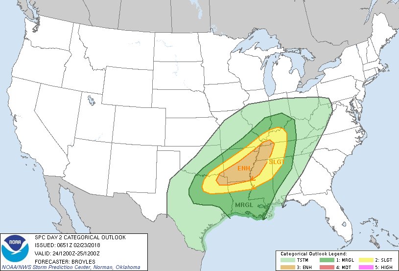
Today there will also be a severe component of this very spring like system:

The front has cleared the Northeast so record heat will be confined to the Southeast through Saturday, but remaining remarkable:
 Ryan Maue | weather.usVerified account @RyanMaue
Highs in the 70s and 80s from Key West to #Atlanta to West Virginia.
(https://weathermodels.com )


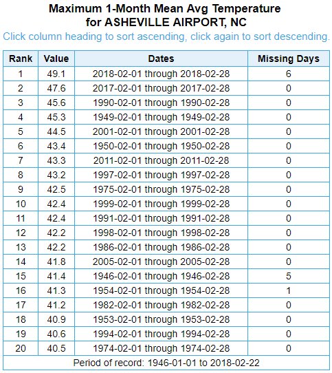
The previous warmest Feb was set last year FWIW.
 Stu OstroVerified account @StuOstro
The @CAEAirport tied its record high temperature today with a high of 82 degrees. The previous record was last set in 1962. This is the 3rd consecutive day that #ColumbiaSC has tied or broken a record high temperature. #scwx
NATIONAL WEATHER SERVICE GREENVILLE-SPARTANBURG SC
430 PM EST FRI FEB 23 2018…RECORD HIGH TEMPERATURE SET AT GREENVILLE-SPARTANBURG SC…
THE HIGH TEMPERATURE TODAY AT THE GREENVILLE-SPARTANBURG AIRPORT WAS
78 DEGREES. THIS BREAKS THE PREVIOUS RECORD HIGH TEMPERATURE FOR
THIS DATE OF 76 DEGREES WHICH WAS LAST SET IN 2017.
IN ADDITION, THE LOW TEMPERATURE SO FAR TODAY HAS BEEN 57 DEGREES.
THIS WOULD EQUAL THE HIGHEST MINIMUM TEMPERATURE ON RECORD FOR
FEBRUARY 23. THE PREVIOUS RECORD HIGHEST MINIMUM TEMPERATURE FOR
THIS DATE WAS SET IN 1922.