Wednesday October 3rd… Dear Diary. The main purpose of this ongoing post will be to track United States extreme or record temperatures related to climate change. Any reports I see of ETs will be listed below the main topic of the day. I’ll refer to extreme or record temperatures as ETs (not extraterrestrials)😊. Here is today’s main climate change related topic:
Holy Amplified Weather Pattern Batman! October Will Be Very Weird For The United States
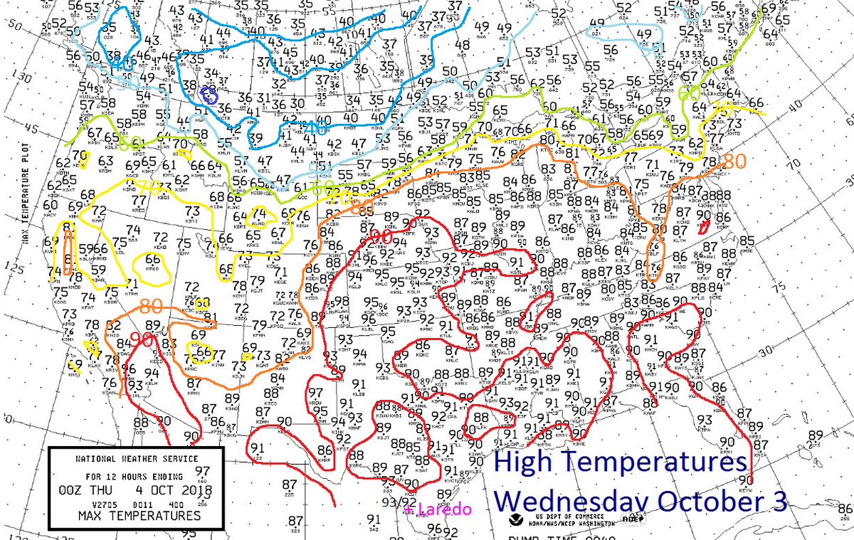
In October many of us are thinking about what to don for many a Halloween party or Trick or Treat outing with kids. A few kids may want to wear Batman or Robin costumes. Well, for a good chunk of the month one would think that the Joker from Batman or some other fictitious fiend will be playing many tricks on the weather from coast to coast across the country. Mr. Freeze will be paying an early visit on the West producing an instant winter while some sort of heat monster will take up residence in the East extending a seemingly endless summer. The battle ground area of the Plains will see all measure of super moist conditions where the Penguin would be right at home. Seriously, though, climate change signatures are starting to appear all over the U.S. map.
I first alluded to this coming weather pattern here:
Since posting this Rosa has left its unusual wet mark on the Southwest the first few days of this month, dumping several inches of rain on the deserts. For specifics see this new Bob Henson post:
https://www.wunderground.com/cat6/Rosas-Rains-Drenching-Southwest-US-Caribbean-System-Bears-Watching
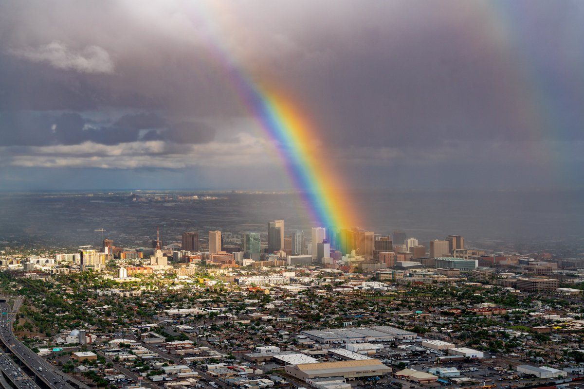
The rain wasn’t all bad falling in drought parched areas in the Colorado River Basin. Rosa left a treat over Phoenix. I wish that I could find a pot of gold at the end of this rainbow.😉:

Check out one of the most intense rainbows we’ve ever seen above Phoenix, AZ #azwx Photo: @geraldferguson

Impressive. The jetstream dip over the West is predicted to make it all the way into Baja California. This is not common.
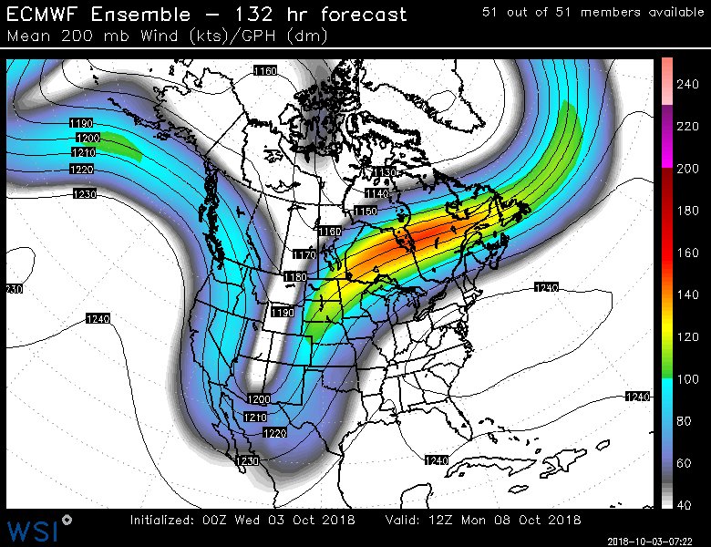
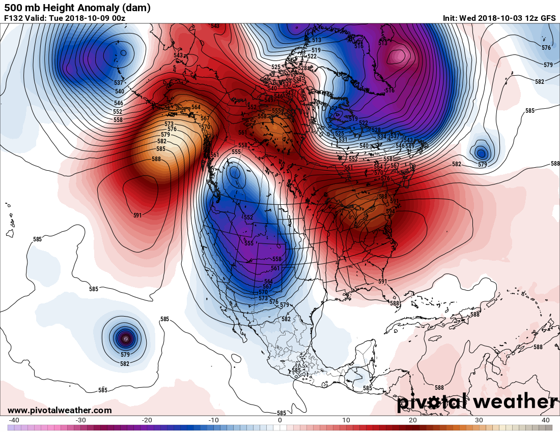
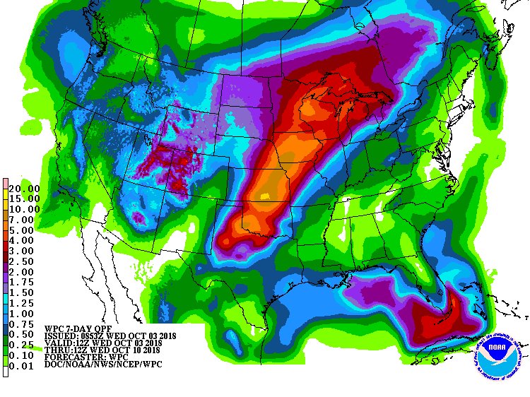
I contend that such a forecast pattern as depicted on the above Pivotal chart is highly indicative of climate change. Not only are 500 millibar heights at record warm levels in the East, but the cold pocket in the West is one giant, cold closed low. As long as the polar vortex remains over the Northern Hemisphere we will continue to occasionally see cold pockets getting squeezed southward producing all sorts of anomalous and sometimes unwanted severe weather. In this case there will be snow in the Rockies, which for most will be welcome and a skiers delight. In the Plains, though, we probably will see some severe weather with flooding, as well.
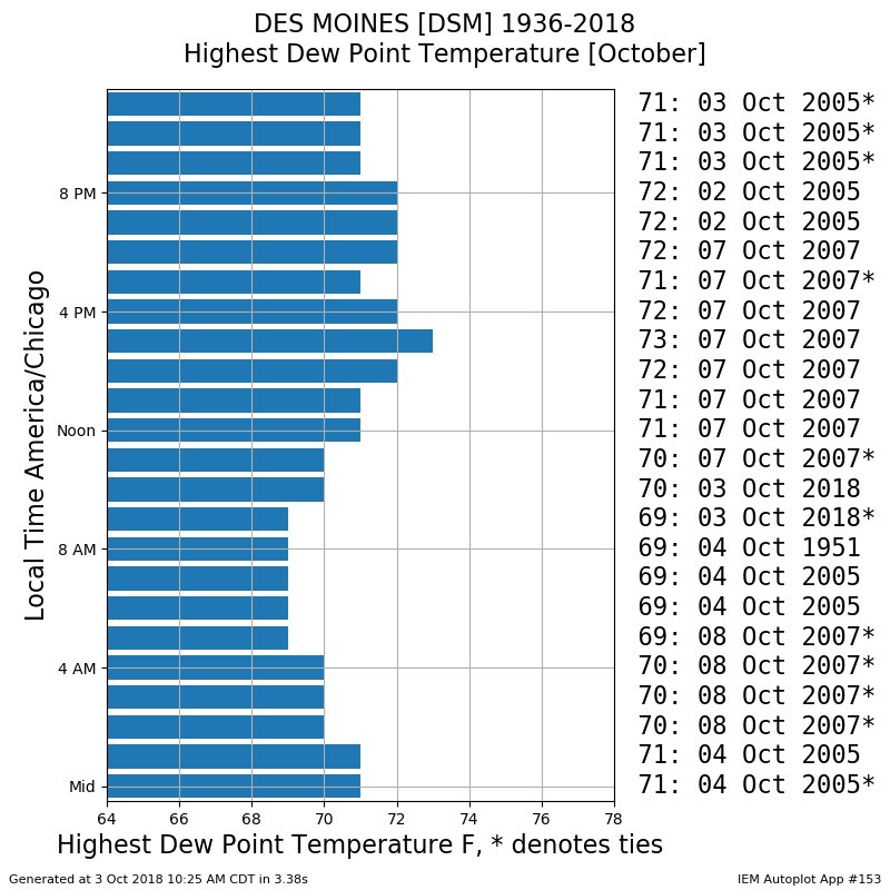
based on my unofficial hourly archives, Des Moines KDSM setting hourly dew point records in October so far today. https://mesonet.agron.iastate.edu/plotting/auto/?_wait=no&q=153&network=IA_ASOS&zstation=DSM&month=oct&var=max_dwpf&dpi=100&_fmt=png…

After Phoenix’s wettest October day on record, torrential rains will head for the Plains this weekend. Some places could rack up storm totals of 10″ or more. https://bit.ly/2DV5s4w

 Jonathan ErdmanVerified account@wxjerdman

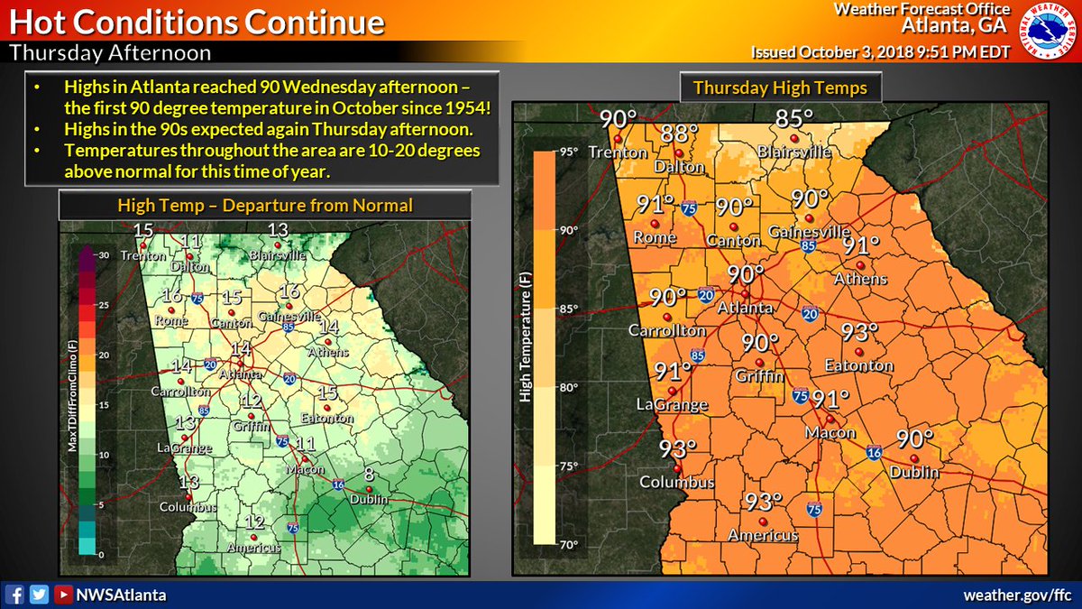
The 90 degree high temperature in #Atlanta this afternoon was the first time a high in the 90s was observed in Atlanta in October since 1954! Highs are expected to reach into the 90s again throughout much of our area on Thursday afternoon, as well. #gawx

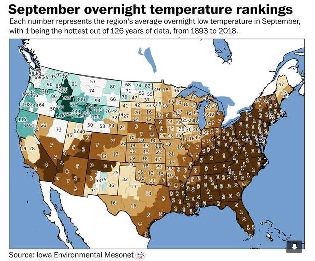
This ugly map encapsulates the weather on the East Coast during the month of September.
“It was hot, steamy, oppressive and smelly. The mud was never-ending. The most generous thing I can say for the month is that it’s finally over.” — @angelafritz https://www.washingtonpost.com/weather/2018/10/02/this-swampy-brown-map-sums-up-september-eastern-us/?utm_term=.c8656be907dd&wpisrc=nl_energy202&wpmm=1…

Where is our snow? #Fairbanks is on track to have one of the latest “first autumn snows” of record. Over the past century, the first snow (any amount, even just a flurry) typically occurs in the second half of Sept. Not this year though. #akwx #snow @Climatologist49 @newsminer


Tropical air Mid-Atlantic states to southwest Great Lakes to southern Minnesota to southern South Dakota southward. Polar air North Dakota, Montana north into Canadian Prairies. Cool air will track north of our tropical air through 7 day forecast time frame. #MYKGNSNEWS
CMC model 10 day Forecast for the Western Atlantic 10/3 12 am While T.S. Leslie meanders about the Atlantic. A low forms off the Coast of Honduras, moves North & strengthens to a T.S. continues through the Gulf & makes landfall on the MS & FL border, then moves NE into the U.S. pic.twitter.com/IR0wvISb8g
— Scott Cook (@scook2214) October 3, 2018
As of this writing most models have backed off on a storm in the Gulf, but the situation there needs to be watched….and I will.
Like taking a trip in the Batmobile most folks will have a wild ride from the weather this month across the U.S. Stay tuned to this site for much more bat crazy weather reports.
(As usual, this will be a fluid post in which more information gets added during the day as it crosses my radar, crediting all who have put it on-line. Items will be archived on this site for posterity.)
(If you like these posts and my work please contribute via the PayPal widget, which has recently been added to this site. Thanks in advance for any support.)
The Climate Guy