Tuesday November 6th… Dear Diary. The main purpose of this ongoing post will be to track United States extreme or record temperatures related to climate change. Any reports I see of ETs will be listed below the main topic of the day. I’ll refer to extreme or record temperatures as ETs (not extraterrestrials)😊.
Return Of The Dipole, Polar Vortex, and Chill For United States
Happy Voting Day in capital letters everyone. I hope that by the time you are reading this post you have voted for progress and science. If not, do so ASAP.
Over the weekend and Monday meteorological models have been trending towards the solution of a very cold pattern by November standards. The orientation of the dipole related western ridge and the extension of the polar vortex developing around Hudson Bay usually spells cold weather for the eastern 2/3rds of the United States, which is not too unusual, but more often than not occurs later in the winter season. Here is what we see from the European model by a week from today:
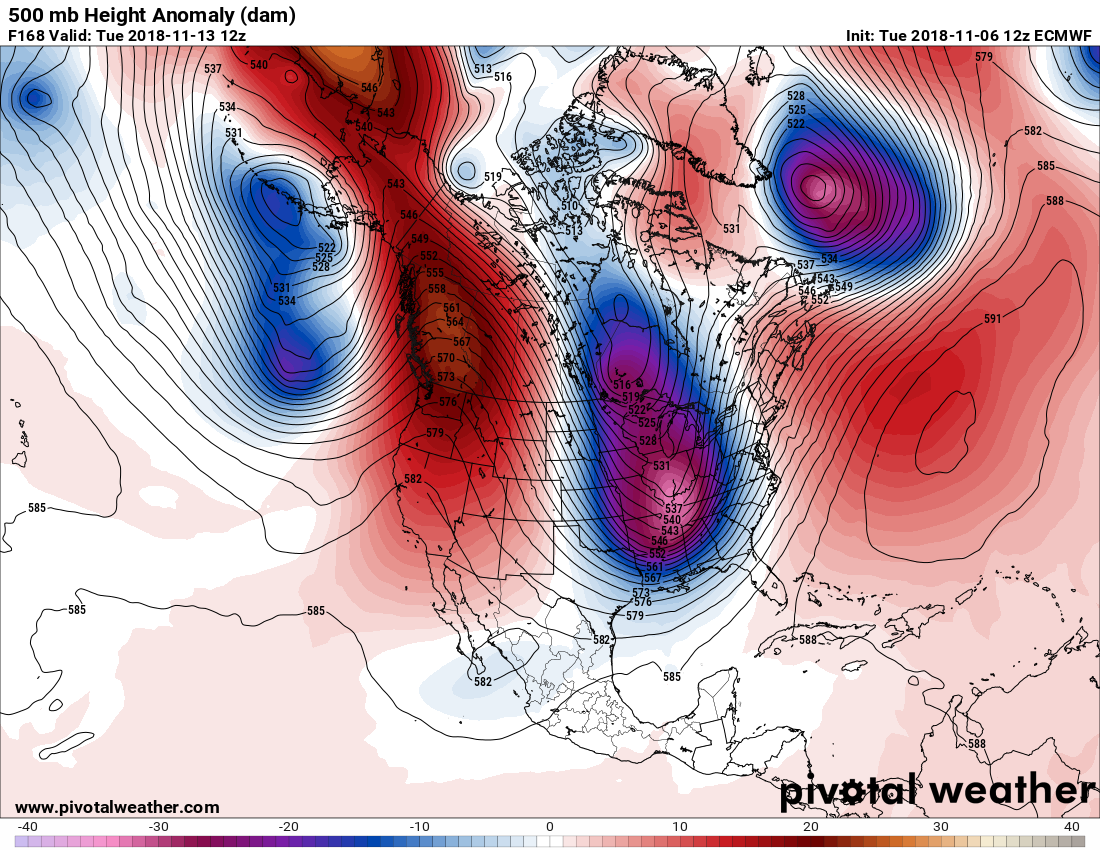
We see an extreme case of amplification with both a western North American ridge and an Atlantic ridge spiking northward to the Arctic and a deep trough in between these features . The jet, at least temporarily, is oriented north-south such that Arctic air building in northern Canada has a clear shot southward to the southeastern U.S. The GFS does forecast a “polar roller,” as we used to call it at The Weather Channel, to move into the Plains at near 1040 millibars ushering very cold air southward through the Ohio Valley towards the South and eventually the Gulf Coast:

A storm system could produce snow in the Appalachians and Northeast, and the old winter lake effect snow machine will definitely turn on. Watch for thundersnow at a few locations around favored lake effect snow zones due to in met speak strong lapse rates. Notice on the above chart a large area within the 522 decameter thickness line from the Upper Midwest into the Ohio Valley. Eyeballing this chart it looks like there will be many record lows established from the Midwest into the Deep South, which I will tabulate for all. So far in November I count about 50 daily record high maxes established in the West from minor stations in association with the western ridge, which is already in place. Look for more record warmth there from this pattern.
So how does cold weather fit in with overall global warming? Climatologists have to explain why every cold season. My take is that so long as there are polar ice caps the planet will spit out cold pools of air southward, thermodynamically balancing out the climate system. As the ice caps shrink and become more unstable during the typical cold season we should see fewer cold outbreaks, and they won’t cover areas nearly as large as those of today and in the past.
The dipole pattern is intriguing, though, because more often than not since about 2012 we are seeing this jet stream configuration leading to very dry weather in California and much of the West with what remains of the last cold spots on the planet in eastern and central North America. November 2018 will definitely be another month of the North American dipole.
…………………………………………………………………………………………………………..
I’ll be adding more weather and climate news to this post as I watch election coverage this evening and night:
(As usual, this will be a fluid post in which more information gets added during the day as it crosses my radar, crediting all who have put it on-line. Items will be archived on this site for posterity.)
"Frightening article that's relevant today" The Arctic needs $1 trillion in investment to mine its riches. Who's good for it? https://t.co/qH0t3tjGEb via @bbgvisualdata
— Scott Cook (@scook2214) November 5, 2018
October sea ice extent in the Arctic ranks third lowest in satellite record. Extent remains especially low on the Atlantic side of the Arctic in the Barents and Laptev Seas, which may relate to the "Atlantification" of the Arctic Ocean. https://t.co/zpByEBSMdx pic.twitter.com/erSCCGlBkC
— National Snow and Ice Data Center (@NSIDC) November 6, 2018
Today was the warmest November day ever, here in central NL; a high of 19.0°C at main met station De Bilt!
In the first 104 years, temperature never exceeded 17.7°C in November. It exceeded 18°C four times since 2005. And now it hit 19°C… pic.twitter.com/5cd2uaOV9e
— Kees van der Leun (@Sustainable2050) November 6, 2018
Is someone compiling a list of hilariously poor weather-related excuses for voting problems today, because…. https://t.co/zb0t4k5Zx8
— Matt Lanza (@mattlanza) November 6, 2018
Exxon loses another round in court; it's got to be a bit unnerving for them, since they're used to total controlhttps://t.co/qUlF0UwcKx
— Bill McKibben (@billmckibben) November 6, 2018
(If you like these posts and my work please contribute via the PayPal widget, which has recently been added to this site. Thanks in advance for any support.)
The Climate Guy