Monday April 29th… Dear Diary. The main purpose of this ongoing post will be to track United States extreme or record temperatures related to climate change. Any reports I see of ETs will be listed below the main topic of the day. I’ll refer to extreme or record temperatures as ETs (not extraterrestrials).😉
First Dangerous Heat For U.S. In 2019
Well, we are seeing a taste of summer a tad early this year across the Southeast, but admittedly the chances for having health problems from any dangerous heat will be low through this week. Only active but unhealthy people who don’t hydrate, and people and animals locked in hot cars may encounter problems. Still, Monday marked the first day of enough widespread maxes above 85F to peg as the first unofficial day when heat could be at least a slight problem for the U.S. in 2019. Some might argue, though, that the first unofficial day may have occurred earlier due to Southwestern Desert heat.
Anyway, as most of my readers know, we refer to 500 millibar height anomaly charts to see how strong heat domes are over a given area. At the “height” of this mini heat wave, which should be on Tuesday and Wednesday, here is what we see from the GFS:

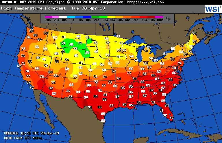
While not unprecedented to my recollection, it’s awfully early in the warm season to see +588 decameter heights over such a large area over the Southeast and Florida. At the surface forecast maxes will be close to record values in the Southeast tomorrow:

Values of maxes from San Antonio to Memphis to Nashville to Richmond and south will be more like those of June than late April. Winter will be hanging on in the northern Rockies.
Here is what Florida temperatures were like on Monday:
The big ridge will be stuck in place for a few days holding a series of fronts in place over the Midwest, setting up another potential flooding situation over a very water logged area:
This early heat will persist until this weekend when the ridge will weaken some allowing a front to move south and east. The front will produce showers and storms through much of the South cooling some, but raising humidity values. Florida will remain toasty, though, south of the boundary.
That’s about it for this first minor heat alert. Of course, due to climate change the U.S. will be very fortunate to be totally unscaved from dangerous heat during this warm season. As always, I’ll report on any forecast heat waves, and at the bottom of each daily post, add “extreme temperature” reports, both hot and cold, or ET’s.
……………………………………………………………………………………………….
Here is some more climate and weather news from Monday:
(As usual, this will be a fluid post in which more information gets added during the day as it crosses my radar, crediting all who have put it on-line. Items will be archived on this site for posterity. In most instances click on the pictures of each tweet to see each article.)
(If you like these posts and my work please contribute via the PayPal widget, which has recently been added to this site. Thanks in advance for any support.)
Guy Walton- “The Climate Guy”