Saturday June 20th… Dear Diary. The main purpose of this ongoing blog will be to track United States extreme or record temperatures related to climate change. Any reports I see of ETs will be listed below the main topic of the day. I’ll refer to extreme or record temperatures as ETs (not extraterrestrials).😉
Main Topic: A Strange And Ominous Case…The Northern New England Heat Wave
Dear Diary. We will officially be in summer across the Northern Hemisphere today with the solstice occurring at 5:43 PM EDT. A few days before the solstice a relatively small area of the United States and Canada experienced an unusual heat wave while most of the rest of the North American continent saw typical late spring temperatures. One tweet I sent out about this odd temperature pattern caused quite the stir:
We had a very atypical 500 millibar pattern set up across the eastern U.S. with an upper low pinching off from the main jet with a strong heat done developing to the north:
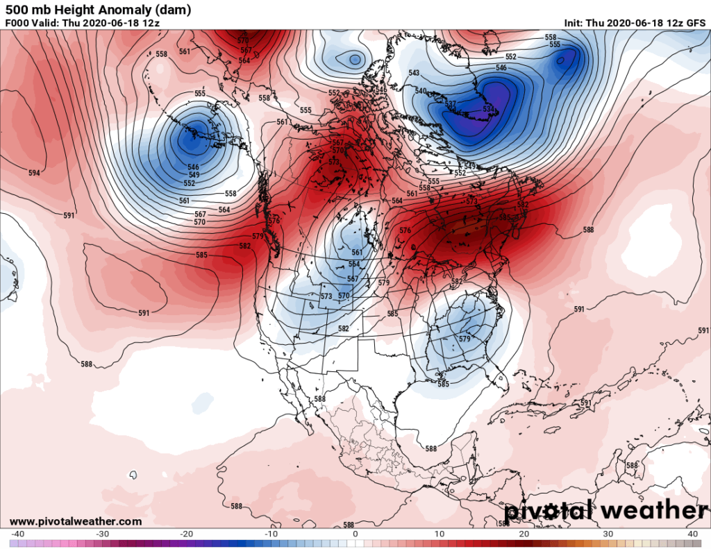
The end result was some remarkable heat at the surface in the far northeastern U.S. For many more details on this here is Matthew Cappucci’s article from the Washington Post.
https://www.washingtonpost.com/weather/2020/06/19/record-heat-maine/
Sizzling heat engulfs northern New England, challenging modern records
Caribou, Maine, hit 96 degrees tying its highest temperature since at least 1939

Potential high temperatures Friday as forecast by the National Weather Service. (WeatherBell) By Matthew Cappucci June 19 at 3:58 PM
One of the Northeast’s northernmost cities experienced its highest temperature recorded Friday, part of a surge of heat sizzling northern New England and eastern Canada. Temperatures soared into the mid- to upper 90s for a second straight day, some 20 or more degrees above average for this time of year.
Signs show the anomalous warmth isn’t soon to relent, a renewed shot of toasty temperatures likely to arrive by next week.
Caribou, Maine, spiked to 95 degrees Thursday afternoon, a record high for the date and a degree shy of the highest temperature observed since at least 1939 on any day, 96 degrees. Then on Friday, it made it to 96, matching the all-time mark first set June 29, 1944 and again on May 22, 1977.
In fact, northern Maine was the hottest location anywhere on the East Coast on Friday.
It comes amid blistering heat that has funneled east of the Appalachians. On Thursday, temperatures climbed into the mid-90s in Fryeburg, Maine, and to 91 in nearby Augusta. Even Bangor, Maine, climbed to 92 on Thursday afternoon.
On Friday, much of northern and eastern Maine topped 90 degrees.
The extreme heat also swelled into eastern Canada, where more than a dozen locations set record highs Thursday. Some locations not only set records for June 18 but approached or exceeded the highest temperatures recorded for any day of the year. The temperature in Bathurst, a town in New Brunswick, Canada, soared to 99 degrees (37.2 Celsius), nearly matching its highest temperature since 1872 of 99.3 degrees (37.4 Celsius). Sept-Îles, a city in eastern Quebec, topped its highest temperature on record by 7 degrees, surging to 97.9 degrees.
Heat of this magnitude is made more likely due to climate change, which has pushed temperatures upward for decades. The University of Maine notes the state’s average temperature has increased 3.2 degrees in the past 124 years, with the rate of warming increasing since 1960.
Temperatures in Southern New England were slightly cooler Thursday, thanks to a flow off the ocean that has held temperatures back into the 70s and lower 80s. It’s nothing in comparison with how cool it has been as of late in parts of the Mid-Atlantic and the Southeast, where a stagnant “cutoff low” has brought persistent cloudiness and below-average temperatures.
[Southwest Virginia, Carolinas see downpours, flooding from stalled weather system]
Exceptional heat in interior New England

Potential high temperatures Friday, as predicted by the National Weather Service. Note that the warmest locations on the East Coast are simulated to be in extreme northern New England. (WeatherBell)
While somewhat localized within the eastern United States, the heat in northern New England and the Merrimack Valley is certainly intense.
“Our average high is only 72, so this is pretty hot,” said Corey Bogel, a meteorologist at the National Weather Service office in Caribou. “A lot of people up here do not have air conditioning, so when you have a stretch here of [several] days with hot weather, a lot of old farm houses can really heat up. And when you have an elderly population, that is always a concern.”
Records at Caribou date back to 1939. Bookkeeping at nearby Presque Isle does extend back a little further, and Bogel noted that station had previously been into the upper 90s.
“They hit 99 back in the 1930s,” Bogel explained. In Caribou, “the 96 is a sort of weaker record … since we don’t have records to cover the entire 20th century.”
Regardless, breaking a temperature record that has stood for more than 80 years is no small feat, especially considering it’s the all-time high for any month that’s at stake. Bogel’s team looked back to find which conditions have historically been most prone to spelling hot temperatures.
“Sometimes when we get air this hot, it’s a case of it coming down from the west northwest over the Canadian prairie,” explained Bogel. “But this is a case where air is just so warm overhead [due to high pressure].”
Dry air primes the atmosphere for toasty temperatures

The European model simulates temperature anomalies Friday, highlighting well-above-average temperatures in northern New England, and atypically cool weather beneath a “cutoff low” in the Mid-Atlantic. (WeatherBell)
A major contributor to the heat has been how exceptionally dry the weather has been lately. More than three-quarters of Maine is considered “abnormally dry” by the U.S. Drought Monitor.
With less moisture in the air, the atmosphere has a lower specific heat capacity — meaning it’s easier for the addition or absence of sunlight to spur hefty temperature swings.
Also instrumental is a westerly component to the wind, explained Bogel, which results in a phenomenon called “downsloping.” When air cascades down a hill or mountain range, increasing atmospheric pressure altitudes compresses the air, causing it to warm. That could give any air mass a bit of a “turbo boost” in terms of warming as it rides into Caribou.
Bogel stated that there are usually three inhibitive factors that can stand between Caribou and a temperature record, but he believed that two of them wouldn’t come into play.
“If there’s a fair amount of wildfire activity in the western U.S. and Canada,” its smoke can filter out some of the sun’s rays, said Bogel. “But we’re not expecting much smoke, which can be a factor here.”
He also said that some afternoons can feature the bubbling up of cumulus clouds, which produce just enough shade to occasionally offset warming. But with the dry air in place, his office is not forecasting much low-level cloudiness.
The only potential fly in the ointment for those eager to get a record?
“I suspect if something goes wrong, it would be us getting some cirrus,” said Bogel, referencing the diaphanous, wispy ice clouds that soar 30,000 to 40,000 feet overhead. They’re quite common and often wafer-thin, but their subtle effects could acutely trim back daytime heating Friday.
“That would be tough at this time range to predict. But I think if we get full sunshine, we have a good potential to exceed that record of 96,” noted Bogel.
A taste of what’s to come

High temperatures Tuesday, as forecast by the National Weather Service. (Pivotal Weather)
Meanwhile, model guidance shows temperatures could be at least 10 to 20 degrees above normal next week over much of interior New England.
Mid-90s are possible for much of the Connecticut River Valley by the start of the workweek, with a bona fide heat wave likely for many. Hartford could hit 95 on Tuesday, Boston may see the lower 90s, and Concord, N.H., could wind up with mid-90s.
Where a “cutoff low” has kept cities unusually chilly

Water vapor satellite image showing the cutoff zone of low pressure centered over northern North Carolina, spreading heavy rainfall over Southwest Virginia on Wednesday. (CIRA/NOAA)
It comes in stark contrast to parts of the Carolinas and southern Mid-Atlantic, where relentless cloudiness and locally prolific rains have accompanied a stubborn dome of mid-level cold air that’s languished over the area all week.
Greensboro, N.C., didn’t break 58 for the high Tuesday, after a Monday that failed to climb above 63. In fact, it marked the third-chilliest three-day period this deep into meteorological summer on record.
Even Richmond hung in the 60s on Monday and Tuesday, as did Raleigh, N.C. In fact, Raleigh’s high temperature Wednesday was only 62 degrees — cooler than their average low.
That bowling ball of cold is disintegrating now though, relinquishing its grip on the Piedmont and the Mid-Atlantic. And much like in many locales along the East Coast, temperatures are likely to build to 90 or even higher for much of next week.
Jason Samenow contributed to this report.
…………………………………………………………………
By Monday models will have a better handle on an impeding heat wave slated for the last few days of June and early July, which we will look at in more detail. We will see if the small heat wave in New England is a precursor to something monstrously large, hot, and prolonged once the timeframe for any such event gets well within my 240 hour out threshold of reliable guidance.
Here is more climate and weather news from Saturday:
(As usual, this will be a fluid post in which more information gets added during the day as it crosses my radar, crediting all who have put it on-line. Items will be archived on this site for posterity. In most instances click on the pictures of each tweet to see each article. The most noteworthy items will be listed first.)
Here are some “ET’s” from Saturday:
Now here are some of today’s articles and notes on the horrid COVID-19 pandemic:
(If you like these posts and my work please contribute via the PayPal widget, which has recently been added to this site. Thanks in advance for any support.)
Guy Walton “The Climate Guy”