Saturday July 4th… Dear Diary. The main purpose of this ongoing blog will be to track United States extreme or record temperatures related to climate change. Any reports I see of ETs will be listed below the main topic of the day. I’ll refer to extreme or record temperatures as ETs (not extraterrestrials). 😉
Main Topic: Historic Heat Wave Will Compound COVID-19 Issues For U.S. In July
Dear Diary. Happy 4th of July everyone. Get out and enjoy the outdoors today for the holiday if it is not too hot in your area because very soon it may be too torrid for many across the country to want to venture away from air conditioning.
Before we delve into the details of this forecast historic heat episode, today we are starting with a clean slate from coast to coast with very few National Weather Service advisories out for any given location:

Some places like Washington D.C. have been experiencing a low level heat wave, but there are not any blistering conditions widespread enough to warrant describing what we have as a CAT 1 heatwave:
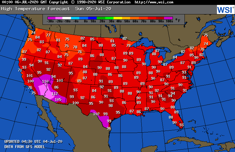
As far as heat goes across the United States, the most eye opening major location continues to be Miami, mainly because that city is surrounded by record breaking warm ocean waters exacerbating their heat wave:
On Sunday the 5th we will not have many atypical heat issues from coast to coast, just run of the mill early July weather:
Now we come to the bad news. For about a week I have been eyeballing met charts, which have been consistently forecasting a major heat episode developing in the Plains, which will likely spread east starting late this coming week and continuing for many days, perhaps weeks thereafter.
By Thursday a major heat dome will start to build from the Southwest into the Plains:
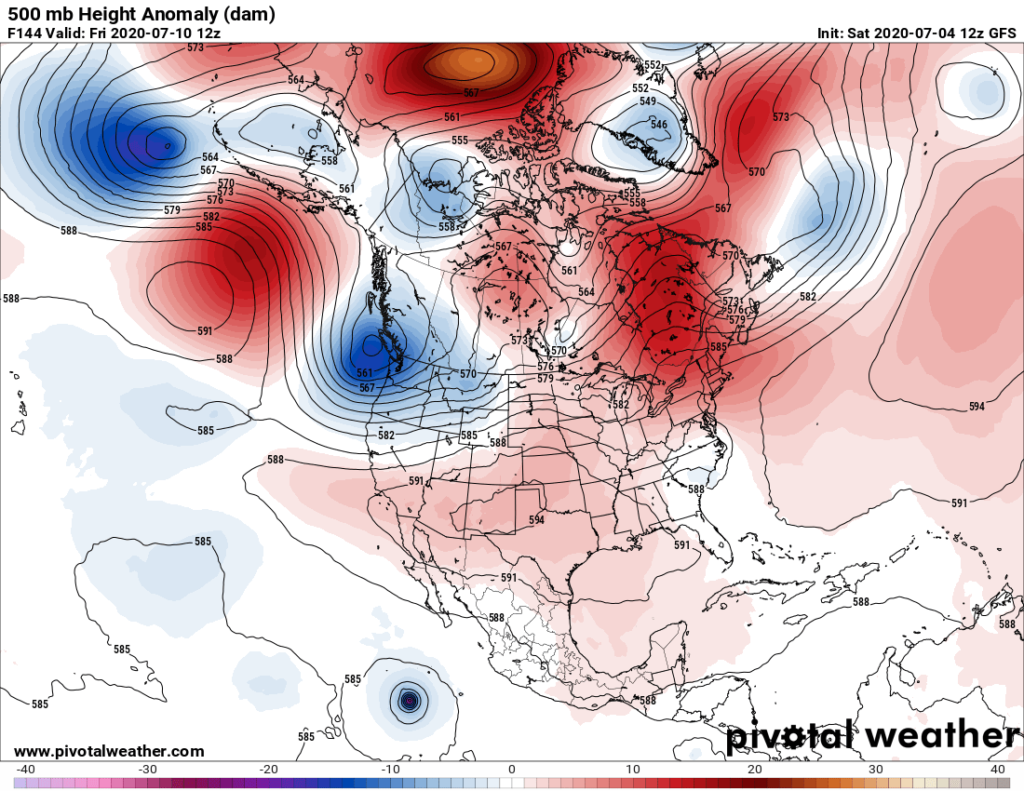
At its zenith the thing could be approaching 600 decameters by the following Monday:

I’ve been hesitant to forecast this heat wave until seeing met models showing consistency from model run to model run, well within the 240 hour out timeframe. Truth be known in June it looked like such a heat wave would start, but an unforseen by most models upper low developed over the Northeast and mid-Atlantic keeping record heat at bay.
This time around model consensus, as noted by ensembles, gives me confidence that a historic event is likely. (Note all of the model runs forecasting a 594 decameter ridge over the heart of the U.S. as indicated by the many brown circles. The current operational model’s 500 millibar height line is depicted using white lines on the following Penn State ensemble chart.):

Jeff Berardelli of CBS has already picked up on what met models are telling us, posting this report:
I’m sure that any severe heat wave will just compound COVID-19 issues as people huddle inside in AC to keep cool. Yesterday I did post an NBC article about the science behind AC potentially spreading coronavirus among folks:
The only area of the country that will escape above average heat will be the immediate West Coast and the Pacific Northwest going out in time a full two weeks.
Instead of posting a usual highlighted climate crisis related article as the main topic of the day from here on out I will be updating all on this impending heat wave, ceasing when the heat episode has ended.
Here is more climate and weather news from Saturday:
(As usual, this will be a fluid post in which more information gets added during the day as it crosses my radar, crediting all who have put it on-line. Items will be archived on this site for posterity. In most instances click on the pictures of each tweet to see each article. The most noteworthy items will be listed first.)
Now here are some of today’s articles and notes on the horrid COVID-19 pandemic:
(If you like these posts and my work please contribute via the PayPal widget, which has recently been added to this site. Thanks in advance for any support.)
Guy Walton “The Climate Guy”