Wednesday August 12th… Dear Diary. The main purpose of this ongoing blog will be to track United States extreme or record temperatures related to climate change. Any reports I see of ETs will be listed below the main topic of the day. I’ll refer to extreme or record temperatures as ETs (not extraterrestrials).😉
Main Topic: A New Western Heat Wave That Gets A Name…Beelzebub
Dear Diary. The push is on to name severe, prolonged weather events in the meteorological world in order to focus the public on associated danger. Hurricanes were named first starting in the mid 20 century. Last decade The Weather Channel began naming winter storms. In Europe heat waves are now getting names. “Lucifer” was devilishly hot last year:
So, it is not too much of a stretch for heat waves in the United States to get names. Of course, many people involved with weather will debate criteria for a heat wave to get a name. It’s my opinion that these heat episodes need to at least produce some hot record reports and be prolonged, not here today and gone tomorrow events, in order to get a name.
Early in July before an unnamed heat wave I did come up with heat wave categorization criteria:
I now propose that once a heatwave reaches my “CAT 2” status in the United States it deserves a name:
“CAT 2: Medium level heat wave in which areas have been subjected to temperatures and humidity sufficient to produce NWS heat advisories and warnings for at least three consecutive days over a widening area about the size of Texas. Temperatures may get close to record levels for a couple of days.“
We now have a western heatwave that will be quite severe and prolonged going into August and has now reached my CAT 2 status. There is danger that the thing go to CAT 3 status or worse as we move through this month. My first name revolving around a hellish theme for this event is “Beelzebub.”
The West over the last few years has be no stranger to heatwaves due to a tendency for the jet stream to kick into a “dipole” pattern. Conversely, this is one reason why in 2019 and 2020 the Midwest has seen some heat relief. Prior heat domes in 2020 have had a tendency to build directly over the Southwest severely limiting the traditional climatological monsoon. If these were to build over the southern Plains Gulf moisture would be funneled westward on easterly winds into the Southwest, producing refreshing thunderstorms, which limit excessive temperatures. A drought is now evident over much of the West:

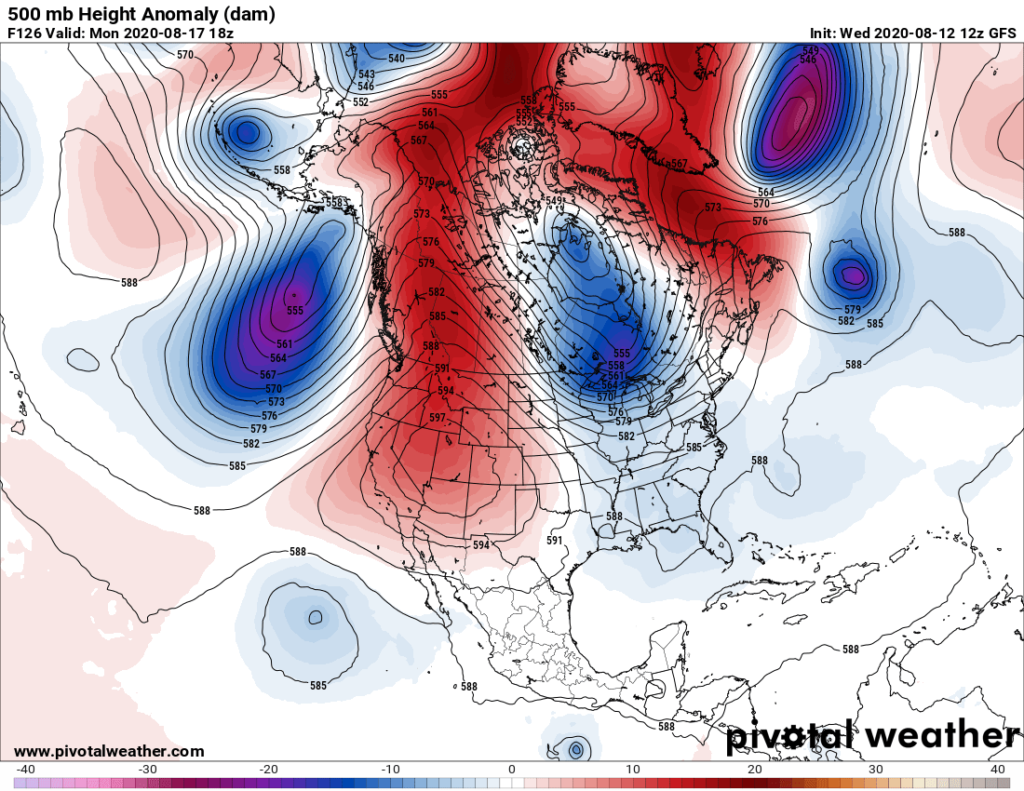
Drought breeds drought and above average temperatures in a devilishly hot feedback loop. My eyebrows have been raised looking at how strong the ridge will get over this drought area, which is forecast to be at its zenith on Monday:
The ridge is forecast to be in place directly over the West through next week producing this temperature regime:

Thursday’s maxes will be at near record levels in spots from Texas westward through California:

In the space below I will be adding some National Weather Service tidbits on Beelzebub. Let’s see how devilishly hot this beast will get.
Here are some “ET’s:”
Here is more climate and weather news from Wednesday:
(As usual, this will be a fluid post in which more information gets added during the day as it crosses my radar, crediting all who have put it on-line. Items will be archived on this site for posterity. In most instances click on the pictures of each tweet to see each article. The most noteworthy items will be listed first.)
Now here are some of today’s articles and notes on the horrid COVID-19 pandemic:
(If you like these posts and my work please contribute via the PayPal widget, which has recently been added to this site. Thanks in advance for any support.)
Guy Walton “The Climate Guy”