Saturday September 5th… Dear Diary. The main purpose of this ongoing blog will be to track United States extreme or record temperatures related to climate change. Any reports I see of ETs will be listed below the main topic of the day. I’ll refer to extreme or record temperatures as ETs (not extraterrestrials).😉
Main Topic: Fire And Ice…The Strange Western Weather Pattern That Could Lead To Deadly Results
Dear Diary. By now if you are a reader of this blog you know that over the last few days I’ve started to emphasize the seriousness of the latest western heatwave named Chort, which was a medieval eastern European demon. We do see quite the devilish predicament building across the western third of the United States, particularly in California:
Just about all Weather Service advisories on this Saturday have to do with either heat or fire…not something good for the holiday weekend:

What I haven’t emphasized, so far, is a record setting early September cold shot heading southward through the Rockies that will produce a tight surface pressure gradient from the Great Basin into California which will cause…you guessed it…the first Santa Anas of the season in California.
These strong easterly winds will be interacting with record heat over the area to produce tender box conditions over much of California. Large fires already burning over the state will jump lines, becoming larger conflagrations and may even consolidate by early next week.
Obviously, officials are already in high alert for more deadly, historic fires that could potentially get out of hand, killing many and burning thousands of structures. Today let’s break down some synoptic meteorology leading to this alarming situation.
First:
There hasn’t been any change, unfortunately in Tuesday’s forecast from yesterday. At the surface here is what we see across the United States for Tuesday morning:
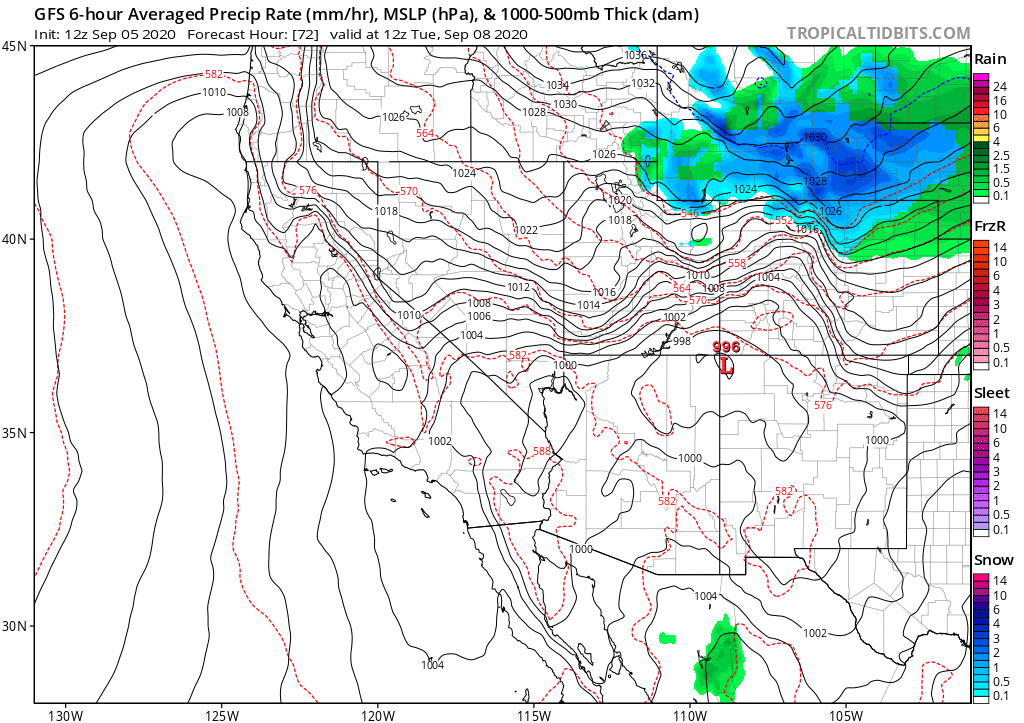
A very early for the fall season snowstorm will be moving through Wyoming and Colorado’s Front Range. You can see a tight pressure gradient building from Utah into Northern California where Diablo winds will be kicking in, stirring up a lot of trouble.
And by the way, despite anomalously high levels of heat across the planet due to carbon pollution, we are way overdue for a cold shot in a section of the U.S. that will produce many records, and this will be it. This winter I’ll come up with criteria to name cold outbreaks, similar to what I now have for heatwaves.
By Wednesday morning the gradient will be lessening, but Santa Ana winds of more than 30 mph will still play havoc with firefighting efforts:

Here are more notes from experts on this developing deadly western situation:
Here are some more of the most recent “ET” reports:
Here is more climate and weather news from Saturday:
(As usual, this will be a fluid post in which more information gets added during the day as it crosses my radar, crediting all who have put it on-line. Items will be archived on this site for posterity. In most instances click on the pictures of each tweet to see each article. The most noteworthy items will be listed first.)
Now here are some of today’s articles and notes on the horrid COVID-19 pandemic:
(If you like these posts and my work please contribute via the PayPal widget, which has recently been added to this site. Thanks in advance for any support.)
Guy Walton “The Climate Guy”