The main purpose of this ongoing blog will be to track United States extreme or record temperatures related to climate change. Any reports I see of ETs will be listed below the main topic of the day. I’ll refer to extreme or record temperatures as ETs (not extraterrestrials).😉
Global Warming Manipulating The Polar Vortex…One Ironic Reason For Spain’s Recent Heavy Snow
Dear Diary. It’s now the dead of winter in mid January, and I’m glad to report that climate change hasn’t gotten so bad that typical winter events, such as cold weather and snow, haven’t gone the way of the dinosaurs. Many times since the 1980s climate change denialists have pointed to extreme winter events as proof that global warming is not occurring, but looking at NOAA and NASA charts we know that what they state is not true. So what gives? How can we continue to see harsh wintry weather in a warming world? The answer lies in what is happening to the polar vortex, which controls the jet stream.
Yesterday I posted plenty of pretty pictures and video of heavy snow that has recently fallen in Spain. Here are those tweets again:
By most accounts Spain has not seen snow this heavy in about seventy years. Well, if the planet was warming at a good rate Spain should not see a snow event as heavy as seventy years ago for millennia to come, right? Well, wrong considering what is happening to the polar vortex.
I also posted my main reason for why this event occurred:
In the last couple of weeks a well forecast event happened to the atmosphere that made areas located in mid latitudes more susceptible to heavy snow than average. This would be sudden stratospheric warming. Jeff Berardelli has a good explanation for that here:
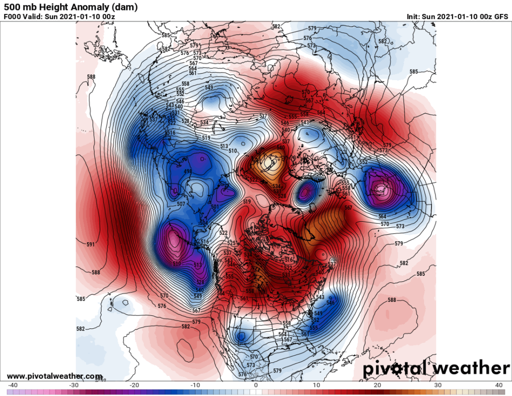
Here is another shot of the closed low that produced Spain’s snow:
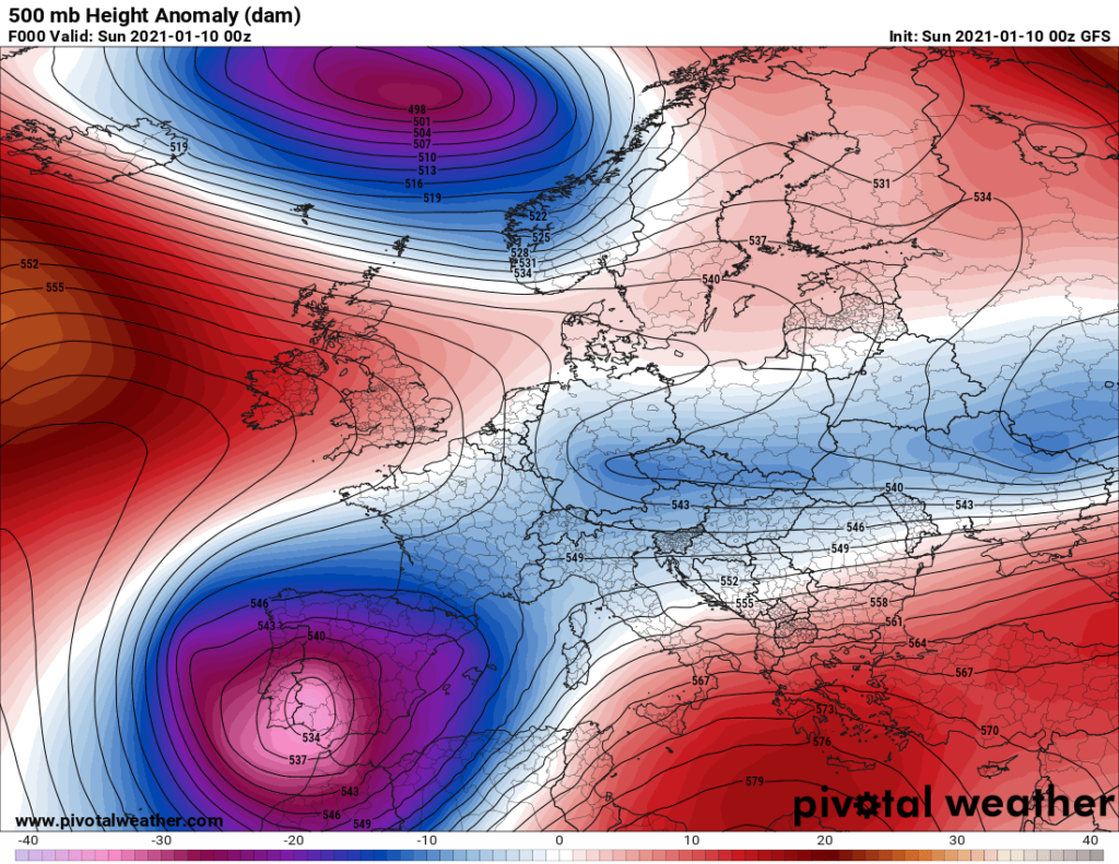
Now let’s zoom out to see what was going on with the polar vortex around the Northern Hemisphere:
Wow! This is about as disturbed of a January pattern as I have seen in my nearly fourty years of being a meteorologist. Stratospheric warming has also warmed the lower level troposphere such that we see a huge warm anomaly over the North Pole with many smaller cold pockets meandering around mid-latitude areas. One is the strongest was occurring around the Iberian Peninsula on Friday into Saturday.
This should be another “drunken meandering jets stream” textbook case for Dr. Michael Mann. It’s well worth reprinting his explanation of what can happen when global warming interacts with the polar vortex:
https://www.ecowatch.com/does-polar-vortex-mean-so-much-for-global-warming-1881858449.html
Does Polar Vortex Mean ‘So Much for Global Warming’?
Jan. 30, 2014 08:39AM EST

Over the past couple of months, the U.S. has seen the return of something many believed had been lost for good: cold weather.
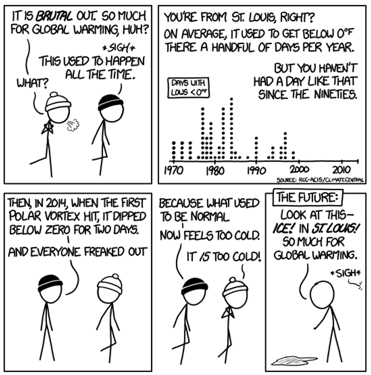
Although the current temperatures in the eastern U.S. may seem unusually cold, in the context of our history they really aren’t. In fact, most of the cold that has made the news lately hasn’t been all that chilly compared what was “normal” for the 20th century. The AP explained our short-term memory loss in this article, Scientists: Americans are becoming weather wimps, the nerdy web comic XKCD captured the sentiment even more concisely.
The bottom line? Because the last decade was the hottest on record (and just a year ago, the U.S. saw its warmest year ever) Americans have grown accustomed to warmer winters that make normal cold feel extreme.
Some then wonder why this winter has been so (normally) cold and why temperatures in Peoria this winter have not been warmed by climate change to, say, a balmy 60 degrees F. The climate denial bubble claims that the cold winter weather means that surely CO2 cannot be warming the atmosphere. How can there be global warming if it’s snowing outside, after all?
Well, the short answer is that cold winters still happen even in a warmed world, but that doesn’t mean it’s cold everywhere. In fact, we don’t even have to leave the U.S. to find a very striking image of warming. We just have to shift our attention from the East to the West Coast. Alaska, usually snowy and frigid, has had two weeks of record high temperatures. Amazingly, the second half of January has averaged 40 degrees F above normal during some days in the central and western parts of the state.
The persistently jagged jet stream we have witnessed in recent weeks has led most recently to what some have termed a “Drunken Arctic.” Stumbling south with polar winds and snow, this unexpected meteorological event seems to have caught our collective attention. And why shouldn’t it? It is an unusual enough, if not unprecedented, event. And it has rekindled curiosity over how human-caused climate change may be impacting the jet stream and the weather systems associated with it.
So, is there a climate connection to this strange occurrence? While more study is certainly needed, I have been increasingly impressed by the growing body of evidence supporting the hypothesis that climate change may lead to more persistent meanders in the jet stream. In a world without global warming, the temperature difference between the freezing Arctic and warmer lower latitudes creates a pressure field that confines the jet stream to a relatively tight band around the Arctic, with wave-like meanders characterized by ephemeral “ridges” and “troughs.” As the Arctic melts and warms, however, that temperature difference is reduced, and the meanders of the jet stream potentially become more pronounced and more sluggish. The more sluggish and persistent those meanders, the more persistent the patterns of regional warmth where the jet stream pulls warm air northward, and the regional cold where it pulls arctic air south.
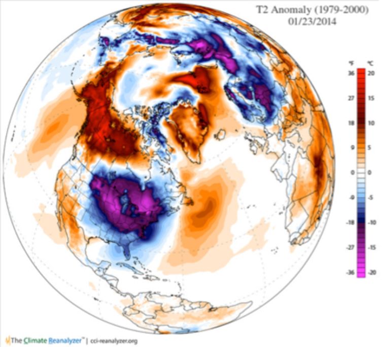
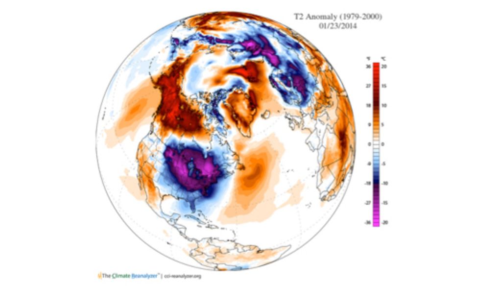
Looking at this image of temperature deviations we can see how the Arctic, in its “drunken” meandering, has fallen head over heels, hitting the southeastern U.S. like an over-enthusiastic reveler face-planting in the gutter shortly after closing time. The large purple region over the eastern U.S. represents weather 20 degrees F colder than the 1979-2000 average. Compare that to the massive red expanse over Alaska and Canada, which indicates weather 20 degrees F warmer than the same baseline.
Perfectly encapsulating the upside-down, hung-over Arctic is this remarkable observation, courtesy of Jeff Masters of the popular Weather Underground blog: At 10 p.m. on Jan. 26 the temperature in Homer, Alaska (54 degrees F) was warmer than any other place in the contiguous U.S. except southern Florida and southern California.
As we approach Groundhog Day, celebrated in the iconic nearby town of Punxsutawney, the question we’re all asking here in central Pennsylvania of whether or not we’ll see an extended winter may in fact depend on what is happening instead thousands of miles to the north in the melting Arctic.
And the very same jet stream configuration responsible for the southward plunging Arctic air mass that chilling the eastern U.S. is associated further to the west with a “ridge” of high pressure that is pushing the warm, moist subtropical Pacific air masses that would normally deliver plentiful rainfall (and snowpack) to California well to the north.
Climate scientists were beginning to suspect a decade ago that the dramatic loss of Arctic sea ice might alter the jet stream in precisely this way, favoring conditions eerily like what we are seeing right now in California: unprecedented and devastating drought.
So to conclude, I propose a toast to the Arctic, whose instability should serve as a wake-up call to those steeped in denial. When it comes to kicking our “fossil fuel addiction” (as former president George W. Bush referred to it), let’s hope we’re not much further from hitting rock bottom. Because when a drunken Arctic leaves Alaska warmer than Georgia in mid-winter, and California as high and dry as it has ever been, we should know we may have a problem.
Visit EcoWatch’s CLIMATE CHANGE page for more related news on this topic.
Nevertheless, it can be argued that since we’ve always seen snow at times as far south as Madrid for as long as humans have been on this planet that global warming did not play much of a part this go round. That’s what attribution studies are for.
Will this pattern lead to a snow event (preferably on a weekend to avoid a traffic nightmare for adults) in Atlanta later during the winter for kids around here to remember? I hope so. We haven’t seen a significant snow event here since December 2017.
Will global warming eventually snuff out any residual cold pockets within our weakening polar vortex? If trends continue and we don’t do more to control carbon pollution, probably so. Just when in the future will it be too warm for snow to occur at latitudesas far south as Madrid? That’s s question for climate scientists to begin to answer.
Related:
………………………………………………………
Here are some “ET’s” from Sunday:
Here is more climate and weather news from Sunday:
(As usual, this will be a fluid post in which more information gets added during the day as it crosses my radar, crediting all who have put it on-line. Items will be archived on this site for posterity. In most instances click on the pictures of each tweet to see each article. The most noteworthy items will be listed first.)
Now here are some of today’s articles and notes on the horrid COVID-19 pandemic:
(If you like these posts and my work please contribute via the PayPal widget, which has recently been added to this site. Thanks in advance for any support.)
Guy Walton “The Climate Guy”