The main purpose of this ongoing blog will be to track United States extreme or record temperatures related to climate change. Any reports I see of ETs will be listed below the main topic of the day. I’ll refer to extreme or record temperatures as ETs (not extraterrestrials).😉
Main Topic: California To See Another Case Of “Precipitation Whiplash”
Dear Diary. It’s been a while since I’ve written a weather post, mainly because the weather has been very tranquil with mild temperatures by winter standards occurring since December 1st across most of the United States. That’s about to change this week as a deep cold trough aloft mills around the western United States, ejecting storm after storm through the Midwest and East.
Most of you know that I follow Bob Henson’s messages on Twitter religiously so that I can bring to you the latest pressing climate and weather news. Here is one that really caught my eye yesterday:
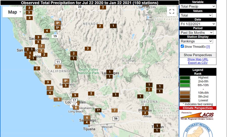
First, as we know California and much of the western half of the country is going through a historic drought. Here are current conditions:

Now let’s blow up Jeff Berardelli’s graphic:
So, to start off this week we have drought at historic levels across the Southwest, in some locations the worst in recorded history. A big change towards wetter weather would be welcome, right? Well yes, but not a deluge as is expected this week. Here is more from my go to guy for all things West, Dr. Daniel Swain:
Precipitation this heavy will put a huge dent in the drought but can be very damaging, causing mudslides in burn scar areas that unfortunately were hit with wildfires in the last several months. Obviously flooding and flash flooding will be a problem.
So, what is the climate change angle on this weather “whiplash” pattern going from extremely dry to excessively wet at near the snap of one’s fingers? Let’s circle back around to Bob’s 2018 post, which technically describes dynamics at play so that we get “precipitation whiplash.” This one is well worth a reprint in light of what will be happening across California this week:
New Study: Precipitation Whiplash is Hitting California, and It’ll Get Worse
Bob Henson · April 23, 2018, 7:09 AM EDT

| Above: Robert Drenic carries a painting from a family member’s home destroyed by a mudslide on January 11, 2018 in Montecito, California. At least 21 people were killed and hundreds of homes were destroyed or damaged. Heavy rain falling atop fire-scorched land upstream from Montecito triggered the mudslides. Image credit: Justin Sullivan/Getty Images. |
Abrupt transitions in California from a parched winter to a soggy one, as observed in the mid-2010s, will become more common if greenhouse gases continue to increase, according to a study published Monday in Nature Climate Change. This “precipitation whiplash” has implications for both wildfire and flood risk. The research also suggests that California’s wet season is likely to contract, and the shorter wet seasons will become more variable, with an increase in both extra-dry and extra-wet winters.
Led by Daniel Swain (University of California, Los Angeles), the study employed 40 climate simulations from the NCAR Community Earth System Model. This large ensemble (CESM-LENS) has been used to simulate climate in preindustrial times as well as the 21st century. Swain and colleagues examined output for the high-emissions or “business as usual” scenario (RCP8.5). It assumes that fossil fuel burning will continue to add ever-increasing amounts of greenhouse gas to the air until the late 21st century.
Ominous hints of an increase in megaflood-prone winters
One of the most worrisome findings is an enhanced risk of extremely wet winters. The modeling indicates that 40-day-long rainfall stretches on par with those observed during the “Great Flood” winter of 1861-62 will be more than three times more likely by the 2070s-2090s than they were prior to human-produced greenhouse gases. A large swath of California’s Central Valley was inundated in early 1862 by torrential rains that produced more than 10 feet of flooding, putting downtown Sacramento under water. A study called ARKstorm found that a repeat of this event could produce hundreds of billions of dollars in damage.
California’s ongoing flood control improvements may not be enough to handle this type of megaflood, as reported by Eric Zerkel in weather.com’s “United States of Climate Change” series.

| Figure 1. A lithograph of K Street in Sacramento during the Great Flood of 1862. Image credit: A. Rosenfield, via Wikimedia Commons. |
Although wet seasons are expected to get shorter on average—pinched between drier autumns and drier springs statewide—the study also projects that the midwinter jet stream will tend to carry more moisture, a well-understood byproduct of a warming climate. At certain times, this juiced-up jet stream could pack a very big wallop. More than two-thirds of the 40 ensemble members indicate that two or more 1862-magnitude rain events could occur in this century across the state.
“On a statewide basis, the overall frequency of 1862-magnitude events increases on the order of 300–400% by the end of the twenty-first century,” write the authors. “Strikingly, these findings suggest that California’s major urban centers (including San Francisco and Los Angeles) are more likely than not to experience at least one such extremely severe storm sequence between 2018 and 2060 on a business-as-usual emissions trajectory.”

| Figure 2. The wet season gets scrunched: Changes in California’s monthly average precipitation at the end of the twenty-first century (2070–2100) as compared to preindustrial conditions, both assessed from the NCAR Community Earth System Model Large Ensemble. Results are shown for each calendar month for a range of latitudes spanning the California coast from 32.5°N to 41.9°N, with the latitudes color-coded. Percentages in the legend denote relative changes in mean “seasonal sharpness” at each latitude, defined as the ratio between precipitation falling during the core rainy season (November–March; blue background shading) to that cumulatively falling during the shoulder seasons (September–October, April–May; red background shading). Image credit: From Swain et al., “Increasing precipitation volatility in twenty-first-century California,” Nature Climate Change 2018, courtesy Nature Publishing Group. |
Digging into the details of precipitation swings
The new study builds on previous work that focused on long-term trends in average California precipitation. For example, a major NOAA report in 2014, “Causes and Predictability of the 2011-14 California Drought,” attributed that prolonged drought (which ended up going into 2016) to natural variability—though the authors noted that the record-setting heat accompanying the drought was likely made more extreme due to human-induced global warming, thus worsening the drought impacts.
NOAA’s 2014 study noted that models used for the most recent IPCC assessment predict an increase in California’s average midwinter precipitation, as does the NCAR model in the new study. However, the 2014 report did not examine trends in year-to-year precipitation whiplash.
According to Swain, changes in the long-term yearly average alone can obscure important year-to-year variability. “Folks would say, ‘There’s no real trend in annual precipitation in the observational record and in climate model simulations, even under pretty significant warming, so what can we say about drought?’ With our approach, we can see that the mean trend masks all the interesting changes that are going on at opposite ends of the precipitation spectrum.”
The new study examined trends in dry-to-wet whiplash from one year to the next, but not in wet-to-dry whiplash. Swain said he would expect both types to increase.
Wet-to-dry whiplash is a recipe for fire trouble. A wet winter in California can foster a richer-than-usual carpet of grasses and shrubs. The bumper crop, along with forests, may then be dried out quickly by very high summer temperatures—which are occurring more often with California drought, exacerbating its impacts. In 2016-17, the second-wettest winter in California history was followed by the hottest summer on record, and then by one of the slowest-starting wet seasons on record. The lack of autumn moisture set the stage for deadly wildfires that devastated parts of northern California in October 2017 and the Santa Barbara/Ventura area in December.

| Figure 3. The glow of approaching flames is seen at the gates of a home in Montecito, California, as the Thomas Fire continued to grow on December 12, 2017. Eventually spanning more than 281,000 acres, the fire was the largest in modern California records, destroying more than 1000 structures. Only a month after this photo was taken, Montecito was ravaged by flash floods that took at least 21 lives. Image credit: David McNew/Getty Images. |
One caveat to the new study is that NCAR’s large-ensemble runs are at standard resolution for global models, so they do not have high enough resolution to depict atmospheric rivers and other such features in fine detail. As a result, Swain said, “We can’t be specific about precipitation amounts.” Instead, the study used an 1800-year-long control run with preindustrial conditions, then determined the most intense storm one might expect every 200 years (analogous to the 1862 event) and assessed how much more often such a storm occurred in the 21st-century runs.
According to Swain, “the increase in extreme precipitation appears to be largely a product of the dramatic increase in water vapor.”
Pulled in both directions: Adapting to enhanced risk of both drought and flood impacts
The new analysis did not find any increase in the frequency of multiyear dry spells in California until very late in the century over far southern California. Even so, rising temperatures would still tend to make the impacts of any single-year drought worse, and the contracting wet season implies a longer period each year when dryness will prevail.
“It looks like we’ll probably have more individual dry years, yet perhaps not more multiyear periods of drought,” Swain said. “Since the adaptations to drought are in many cases the opposite of what you’d do for flood risk, there’s a potential for maladaptation if you focus on one but not the other.”
Based on the new analysis, Swain says the likelihood of an 1862-style megaflood “goes from extraordinarily rare to just very unusual, and that’s a very big problem. We haven’t built any of our infrastructure to accommodate an event like [the flood of] 1861-82, even though we know it can happen because it already did.”
A paper published online last September in the International Journal of Climatology reported on an increase in both wet-to-dry and dry-to-wet whiplash from one winter to the next across California and Nevada since 1895. The study, by Michael Marston and Andrew Ellis (Virginia Tech), defined this phenomenon as “extreme precipitation reversal” and found greater EPR values in the second half of the historical record.
Oklahoma has also been plagued by wild swings in precipitation in recent years, as we discussed in a recent post on a massive wildfire in mid-April. The state experienced its wettest year on record in 2015, and far northwest Oklahoma saw its driest winter on record in 2017-18.
WU weather historian Christopher Burt has a post with meteorological background on California’s Great Flood of 1862. The Los Angeles Times investigated the risks of catastrophic California flooding in a report on March 25.

Bob Henson
Bob Henson is a meteorologist and writer at weather.com, where he co-produces the Category 6 news site at Weather Underground. He spent many years at the National Center for Atmospheric Research and is the author of “The Thinking Person’s Guide to Climate Change” and “Weather on the Air: A History of Broadcast Meteorology.”
More forecasts for this week:
I’ll be posting more notes on the western weather situation this week, as well as what will be occurring across the rest of the United States coming from this very volatile and dangerous pattern.
Here is some more weather and climate news from Sunday:
(As usual, this will be a fluid post in which more information gets added during the day as it crosses my radar, crediting all who have put it on-line. Items will be archived on this site for posterity.
Now here are some of today’s articles and notes on the horrid COVID-19 pandemic:
(If you like these posts and my work please contribute via the PayPal widget, which has recently been added to this site. Thanks in advance for any support.)
The Climate Guy