Dear Diary. The main purpose of this ongoing blog will be to track global extreme or record temperatures related to climate change. Any reports I see of ETs will be listed below the main topic of the day. I’ll refer to extreme or record temperatures as ETs (not extraterrestrials).😉
Main Topic: Major Midwest Flooding…The Next Big U.S. Climate Crisis Weather Disaster?
Dear Diary. Some portions of our south-central states are still reeling from the historic cold outbreak from mid February, which may tally as a more expensive climate crisis related weather disaster than Hurricane Harvey in 2017. In this day and age of increasingly rapid climate change we are seeing a decrease in the time of relative calm periods in between extreme events. Only about two weeks after the big freeze of 2021, or in my book “Yeti,” my meteorological tea leaves are telling me that we have the potential for a whopper of a storm, which probably will bring significant flooding to portions of the Plains and Midwest late this week…a system influenced by the climate change signature of a warmer than average atmosphere.
We will see a big warmup early this week ahead of our storm. We may see a number of warm records ahead of a developing front in the northern Plains looking at thickness values in a huge area of southwest flow. As usual, this would be a climate change signature :

By Thursday into Friday a strong closed low will have developed in the Southwest surrounded by very warm anomalous 500 millibar heights for mid-March:
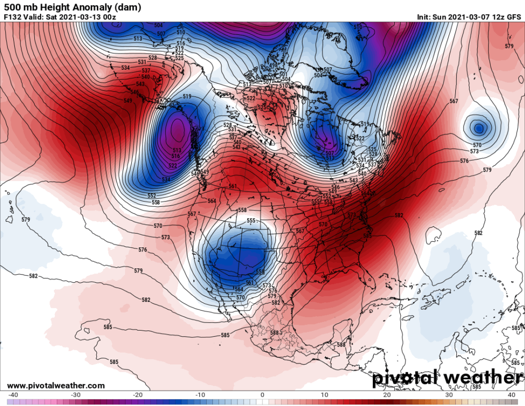
Here we see an example of Dr. Michael Mann’s weakened polar vortex with many warm anomalies protruding northward into the Arctic. The warmth surrounding our Southwest cold low anomaly will serve as a “block,” preventing our storm system from moving eastward at a typical spring clip. As our system starts to interact with a front moving southward through the Midwest storms and heavy rain will result starting on Thursday:

Unfortunately, due to the sluggishness of the system, the front will stall over the central and southern Plains and mid-Mississippi Valley leading to wave after wave of heavy rainfall. At this point we don’t know if this will be a more localized flooding event or something truly historic.
There will be other aspects of this storm system, as well. On the warm side of the thing there is the potential for severe storms with embedded tornadoes. As indicated on the above chart, there will be some heavy snow on the cold side of the system in the Rockies, which would be typical for March, though.
I’ll have many updates of this system as the week progresses.
Here is some more February climatology:
Here is more climate and weather news from Sunday:
(As usual, this will be a fluid post in which more information gets added during the day as it crosses my radar, crediting all who have put it on-line. Items will be archived on this site for posterity. In most instances click on the pictures of each tweet to see each article. The most noteworthy items will be listed first.)
Now here are some of today’s articles and notes on the horrid COVID-19 pandemic:
(If you like these posts and my work please contribute via the PayPal widget, which has recently been added to this site. Thanks in advance for any support.)
Guy Walton “The Climate Guy”