The main purpose of this ongoing blog will be to track planetary extreme, or record temperatures related to climate change. Any reports I see of ETs will be listed below the main topic of the day. I’ll refer to extreme or record temperatures as ETs (not extraterrestrials).😉
Main Topic: Update on Heatwave Drako, Which Peaks in the Northeast Today
Dear Diary. Heatwave stats have been amazing this year coming from many corners of the planet. With every record set let’s remember that during the summer this represents a health problem for a local community. Today let’s focus on best coming from dangerous U.S. CAT3 Heatwave Draco (as I’ve personally pegged it), which will peak in the Northeast today:
https://www.washingtonpost.com/climate-environment/2022/08/04/northeast-midatlantic-heat-wave/
Heat triggers alerts for more than 80 million in central, eastern U.S.
Temperatures over 95 degrees will span from Texas to Montana and from the Mid-Atlantic to Maine on Thursday

August 4, 2022 at 11:35 a.m. EDT

Forecast highs on Thursday from the National Weather Service. (PivotalWeather)
More than 80 million Americans in the central and eastern United States are under heat alerts Thursday because of a punishing combination of temperatures from 95 to 105 degrees and oppressive humidity levels.
10 steps you can take to lower your carbon footprint
“Dangerously hot summer conditions persist in several spots across the U.S.,” the National Weather Service wrote early Thursday.
The most intense heat is situated over two sprawling zones: 1) From the Mid-Atlantic to eastern Maine — which is forecast to reach 95 to 100 degrees. 2) From interior Texas to northern Montana and North Dakota — which is forecast to reach 95 to 105 degrees.

Forecast highs Thursday in the Northeast from the National Weather Service. (WeatherBell)

Forecast highs in the central United States on Thursday. (WeatherBell)
While the highest temperatures will concentrate in the central United States, the most oppressive humidity levels will be found along the East Coast. Heat indexes, a measure of how hot it feels factoring in the humidity, will be comparable in both zones — ranging from 100 to 105 degrees, although a few spots in South Texas may exceed that.
The Weather Service has placed much of the eastern Mid-Atlantic and large areas of the Northeast under heat advisories, including Norfolk, Washington, Philadelphia, Albany, New York City and Boston.
“We encourage everyone to practice appropriate heat-related precautions such as staying hydrated, taking frequent breaks in air-conditioned rooms, and making sure pets and children are not left alone in cars for any length of time,” wrote the Weather Service office serving Boston in a forecast discussion.

Heat advisories in effect on Thursday. (National Weather Service)
Parts of the southern Plains, including San Antonio, Austin, Dallas, Oklahoma City and Wichita — which have endured a historically hot summer — are also under advisories.
San Antonio, which has seen a record 54 days reach at least 100 this year, will add another to that tally. The historical average through Aug. 3 is just five such days.
Hot weather even extends into the northern Plains and northern Rockies, prompting heat advisories and excessive-heat warnings for portions of western Nebraska, western South Dakota and eastern parts of Wyoming and Montana.
Over central and eastern Montana, the combination of hot and dry weather is escalating the fire danger, prompting red flag warnings.
Fire and rain: As McKinney blaze rages, floods hit Northern California
Records could fall
The Weather Service predicts more than a dozen record highs for Aug. 4 could be challenged across the Lower 48 on Thursday.
A few could be in jeopardy in the central United States, where high temperatures will generally be 5 to 15 degrees above normal. San Antonio is predicted to hit 102 — near the record of 103 set in 2011. Houston, which is forecast to reach 101, would be just 1 degree shy of the record high from 1951.
The Weather Service is predicting two records in the Northern Rockies. It’s calling for Sheridan, Wyo., to hit 100, matching the record from 1964, and Glasgow, Mont., to reach 104, surpassing the previous high mark of 102 from 1964.
In the Northeast, numerous records are expected to be threatened:
- Philadelphia is forecast to be 1 degree shy of the record 98 from 1995.
- New York John F. Kennedy Airport is forecast to hit 94, breaking the 2006 record of 93.
- Albany is forecast to be 1 degree shy of the record 98 from 1955.
- Boston is forecast to tie the 1928 record of 96.
- Concord, N.H., is forecast to tie the 1944 record of 97.

How long will the heat last?
In the Northeast, this is a short-lived blast of heat, with substantially above-average temperatures persisting only into Friday. A slow-moving cold front, which will set off heavy thunderstorms Friday, will drop temperatures somewhat over the weekend.
The duration of the heat will also be cut short in the north-central United States by another cold front. Temperatures will drop in the Northern Rockies on Friday and then into the northern Plains by Saturday.
However, the heat will not relent over much of the southern and central Plains, including Texas. This zone will swelter through the weekend, with highs continuing to hover near 100 degrees.
‘Gigantic jet’ lightning is a mystery. These researchers are solving it.
Monday through Wednesday next week, highs in Oklahoma and Texas are forecast to range from 90 to 100 degrees, only a slight improvement.

The American modeling system shows a large area of high pressure, or a heat dome, centered over Kansas on Aug. 11-16. (WeatherBell)
Through the end of next week, the Weather Service projects high chances of above-normal temperatures for much of the central United States in its eight- to 14-day outlook, while the Northeast and Mid-Atlantic catch a break.
This outlook reflects the persistence of a zone of high pressure, or a heat dome, over the middle of the country that has held in place much of the summer.
Human-caused climate change is making these heat domes larger and more intense.

By Jason Samenow Jason Samenow is The Washington Post’s weather editor and Capital Weather Gang’s chief meteorologist. He earned a master’s degree in atmospheric science and spent 10 years as a climate change science analyst for the U.S. government. He holds the Digital Seal of Approval from the National Weather Association. Twitter
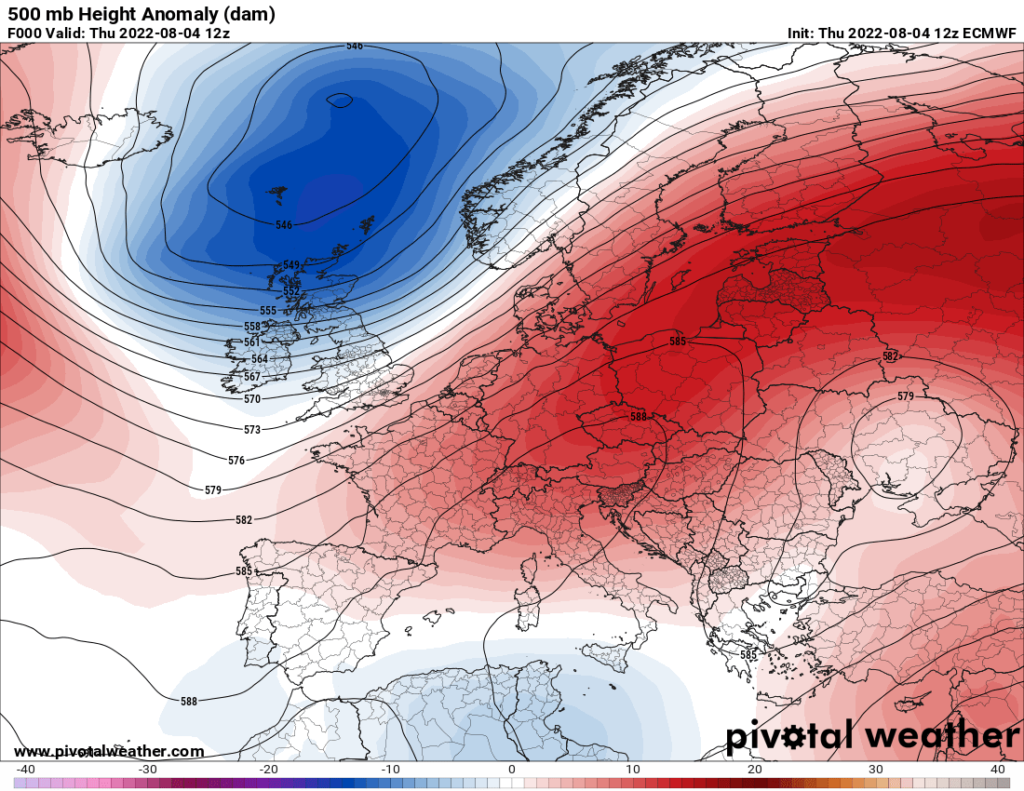
While portions of the United States have been sizzling, let’s not forget that our European friends have been experiencing a heatwave, as well. Here is the heat dome over Europe as of 8/4/2022:
Below you can read some hot stats coming from Europe and the United States:
Here are more “ET’s” recorded from around the planet the last couple of days, their consequences, and some extreme temperature outlooks:
Here is some more July 2022 climatology:
Here is more climate and weather news from Thursday:
(As usual, this will be a fluid post in which more information gets added during the day as it crosses my radar, crediting all who have put it on-line. Items will be archived on this site for posterity. In most instances click on the pictures of each tweet to see each article. The most noteworthy items will be listed first.)
(If you like these posts and my work, please contribute via this site’s PayPal widget. Thanks in advance for any support.)
Guy Walton “The Climate Guy”