The main purpose of this ongoing blog will be to track planetary extreme, or record temperatures related to climate change. Any reports I see of ETs will be listed below the main topic of the day. I’ll refer to extreme or record temperatures as ETs (not extraterrestrials).😉
Main Topic: Global Temperatures “Breaching the Climate Threshold”
Dear Diary. Let’s state that this will be the second part of what I presented on yesterday’s diary post. Today I spotted yet another new article warning that the world may soon breach the first global average temperature line in the sand of +1.5°C (2.7 degree Fahrenheit) above preindustrial conditions due to a burgeoning super El Niño. Climate folks are increasingly becoming more worried about where we are headed this year due to effects from this El Niño.
Here is a little more context:
Already at about +1.2° to 1.3°C we are seeing some horrific effects during 2023, with some of the biggest events being an eye-opening Asian heat wave and what I’ve dubbed Heatwave Amoco, which continues to stew from the Pacific Northwest into western and even northern Canada.
Here is that article I read that was posted early this afternoon by my friend Matthew Cappucci writing for the Washington Post:
Global temperatures could soon briefly breach climate threshold, scientists warn

May 17, 2023 at 12:43 p.m. EDT

A woman shelters from the sun with an umbrella in Chennai, India, on Tuesday. (R. Satish Babu/AFP/Getty Images)
The World Meteorological Organization virtually guarantees that one of the next five years will be the warmest on record, announcing Wednesday that a developing El Niño pattern will overlap with worsening human-caused climate change to push Earth’s temperatures into uncharted territory.
While Earth’s temperatures have fluctuated wildly over its 4.5 billion year history, it’s well established that human emissions are accelerating warming at a breakneck pace, the rapidity of which is distinct from natural processes.
After disasters at coal ash dumps, Biden EPA seeks to tighten loopholes
Experts at the World Meteorological Organization (WMO) anticipate that global temperatures at some point in the next five years will, at least temporarily, spike above the 1.5 degree Celsius (2.7 degree Fahrenheit) benchmark outlined in the Paris Climate Accords, an agreement signed by 196 countries at the United Nations Climate Change Conference on Dec. 12, 2015. That 1.5 degree Celsius number is compared to preindustrial levels.
“WMO is sounding the alarm that we will breach the 1.5 [degree Celsius] level on a temporary basis with increasing frequency,” said WMO secretary general Prof. Peter Taalas in a news release.
Although the WMO suggests the global temperature could temporarily reach that level, separate analyses have previously suggested a more permanent arrival above the 1.5 degree Celsius threshold is more likely to arrive in the 2030s. The WMO suggests there’s a 1 in 3 chance that it will occur in the next five years.
What the WMO is predicting
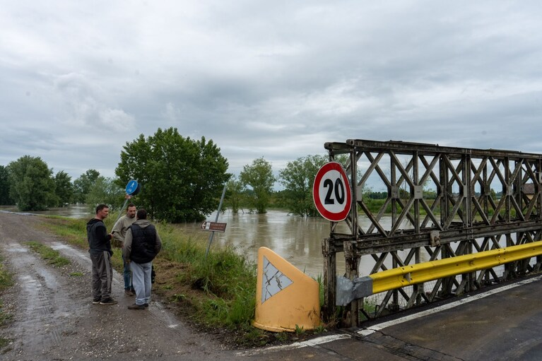
After torrential rain, a branch from the Po River in Modena, Italy, is at a high water level on Wednesday. (Francesca Volpi/Bloomberg News)
The World Meteorological Organization is warning of the following:
- A 66 percent chance, or roughly 2 out of 3 odds, that Earth’s global temperature exceeds the 1.5 degree Celsius (2.7 degree Fahrenheit) above preindustrial levels benchmark at least once in the next five years.
- A 98 percent likelihood, or essentially a guarantee, that at least one of the next five years will go down as Earth’s warmest on record. Records date back to around 1850.
- There is also a 98 percent chance that the upcoming five-year block, 2023 to 2027, could average as the hottest five-year window on record. (The past eight years were the eight warmest on record.)
- Heating of the Arctic is predicted to triple average warming globally. Some peer-reviewed research indicates that a disproportionate warming of the poles can increase the amplitude, or waviness, of the jet stream, leading to more extreme weather patterns. There is also research to suggest reduced periodicity of the jet stream, or a slowing of its west-to-east propagation. That allows weather patterns to become “stuck” for longer.
Emerging research challenges link between jet stream waviness and climate change
Climate change and El Niño overlap
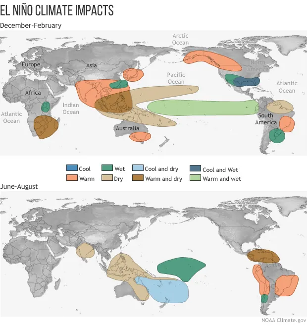
El Niño is known for having impacts on weather around the world, sparking drought in some areas and inundating others with increased precipitation. (NOAA)
The past three years have featured a “triple dip” La Niña, or a global weather pattern born from a cooling of the waters in the eastern tropical Pacific. That fostered sinking motion in the air over the Pacific, in turn allowing rising motion and enhanced hurricane seasons in the Atlantic.
Now meteorologists are anticipating a flip-flop, with an abrupt warm-up of waters in the eastern Pacific. The Climate Prediction Center at the National Weather Service predicts an 80 percent chance of a moderate El Niño developing in the coming months, with a 55 percent likelihood it will be “strong.” There’s also a 90 percent shot it sticks around into the Northern Hemisphere’s winter months.
Earth’s temperature is known to warm during an El Niño. That’s why scientists are concerned about it exacerbating the effects of climate change, which continue to grow.
El Niño is looming. Here’s what that means for weather and the world.
For six of the past seven decades, the warmest year of each of said decades was an El Niño year.
That’s why it’s highly probable that at least one of the next several years, which will inevitably feature an El Niño, will be catapulted above the 1.5 degrees Celsius threshold.
Fitting into a larger pattern
Since 1850, or before the Industrial Revolution, global temperatures have warmed about 1.1 degree Celsius, or about 2 degrees Fahrenheit. That may seem inconsequential, but subtle changes in temperature can have cascading ripple effects on the fundamental behaviors of the atmosphere and the innumerable land, water, ice and ecological cycles that interact with it.
For each degree Fahrenheit the air temperature warms, the air can hold 4 percent more water. (For each degree Celsius, it can hold 7 percent more water.) That means temperature rises are accompanied by an exponential increase in the atmosphere’s moisture-storing capacity. Where moisture is available, flooding rains are becoming increasingly common. Where and when it’s not, drought is becoming more severe and more deeply entrenched.
The warming climate has also been tied to more extreme wildfire behavior and increased areal coverage of land burned, stronger and more rapidly intensifying tropical cyclones/hurricanes, cold-season tornado outbreaks and a litany of other hazards.
While 2016, an El Niño year, still holds the record for the warmest year catalogued by WMO data sets, the past eight years are the eight warmest on record. While it’s impossible to say with certainty where 2023 will end up, the year is already off to an alarming start.
The National Oceanic and Atmospheric Administration has said there’s a greater than 1 in 4 chance that 2023 becomes the new warmest year on record, and a 9 out of 10 chance of it being a top-five year.
After setting a record in 2022, for example, global ocean temperatures are running 0.1 to 0.2 degrees Celsius higher than ever observed by satellites this time of year. That’s mirrored by record global ocean heat content — a known fuel for strong hurricanes.
In just the past few weeks, air temperature records have abounded worldwide. That’s been especially true in Southeast Asia, one of the most densely populated places in the world. On May 6, Luang Prabang in Laos made it to 110.3 degrees, beating out its 108.9-degree all-time record set just last month. Vietnam also broke a national heat record, hitting 111.6 degrees in Tuong Duong. Bangkok got to 104.9 degrees, its all-time record, and Cambodia, as well as parts of China, set records for the month of May.
Heat records have been smashed in the U.S. Pacific Northwest and historic wildfires are burning unusually early in British Columbia and Alberta, Canada, suffocating the city of Calgary in a toxic orange shroud.
And on Wednesday, 35 weather stations in Japan logged their hottest May day on record.
Each of the events is made more likely and intense by the effects of human influence.
By Matthew Cappucci Matthew Cappucci is a meteorologist for Capital Weather Gang. He earned a B.A. in atmospheric sciences from Harvard University in 2019, and has contributed to The Washington Post since he was 18. He is an avid storm chaser and adventurer, and covers all types of weather, climate science, and astronomy. Twitter
Much More:
Here are some more “ET’s” recorded from around the planet the last couple of days, their consequences, and some extreme temperature outlooks, as well as any extreme precipitation reports:
Some More April and May 2023 Climatology (Climatology Presented Daily on This Blog):
Here is more climate and weather news from Wednesday:
(As usual, this will be a fluid post in which more information gets added during the day as it crosses my radar, crediting all who have put it on-line. Items will be archived on this site for posterity. In most instances click on the pictures of each tweet to see each article. The most noteworthy items will be listed first.)