The main purpose of this ongoing blog will be to track planetary extreme, or record temperatures related to climate change. Any reports I see of ETs will be listed below the main topic of the day. I’ll refer to extreme or record temperatures as ETs (not extraterrestrials).😉
Main Topic: Heatwave Chevron to Persist Across the South This Week
Dear Diary. First, I do have to thank my followers and some climate scientists for supporting my efforts for naming heatwaves A) to help focus the public on heat dangers and B) to blame oil companies for their exacerbation this century due to carbon pollution:
Dangerous and historic Heatwave Chevron just goes on and on. After briefly making inroads across the Midwest and Northeast, the thing has set up camp across the U.S. South where it will stay this week.
As an aside, as opposed to during a bad tropical season in which there are numerous named hurricanes, during the worst heatwave seasons there will only be one or two named heatwaves using my system because there won’t be any break from these systems. If we can follow one anticyclonic ridge along, and it doesn’t collapse, its name will continue to be used. Once it collapses and another strong heat dome pops up, I’ll use the next name on my list.
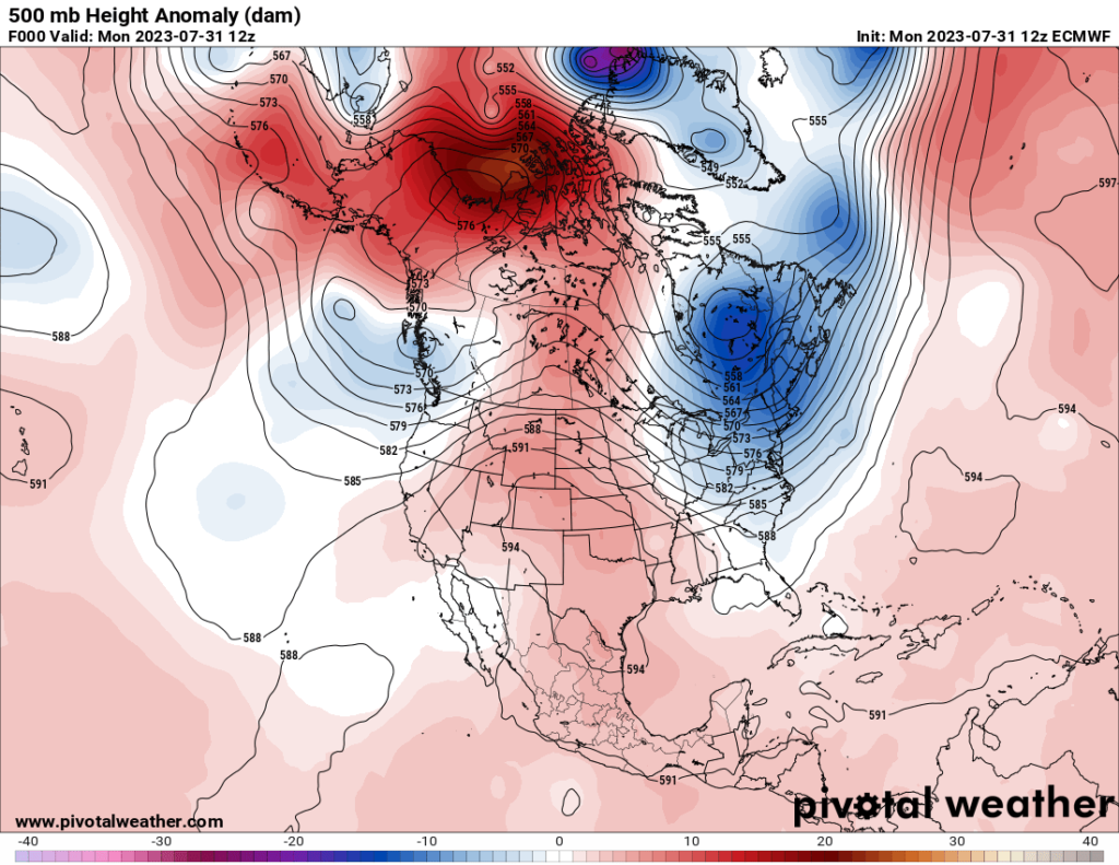
So, to start out this Monday the center of Heatwave Chevron had about a 597-decameter ridge over and was located over the Southern Plains:
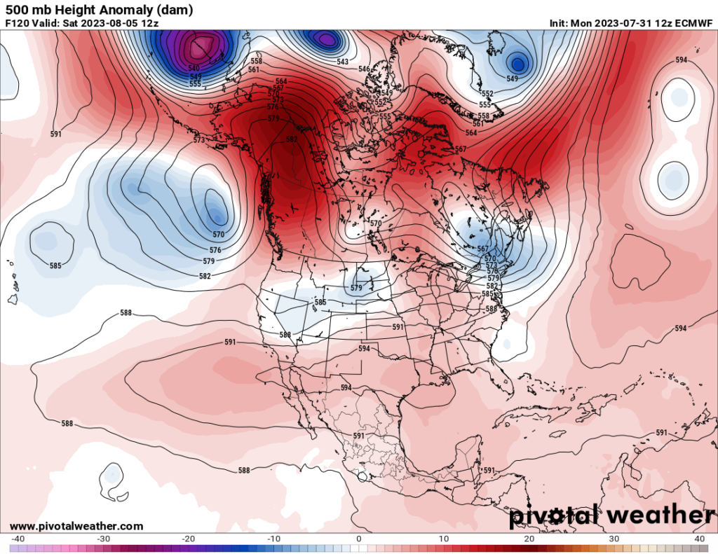
By the end of this week the center of the heatwave will flatten and reside over Texas:
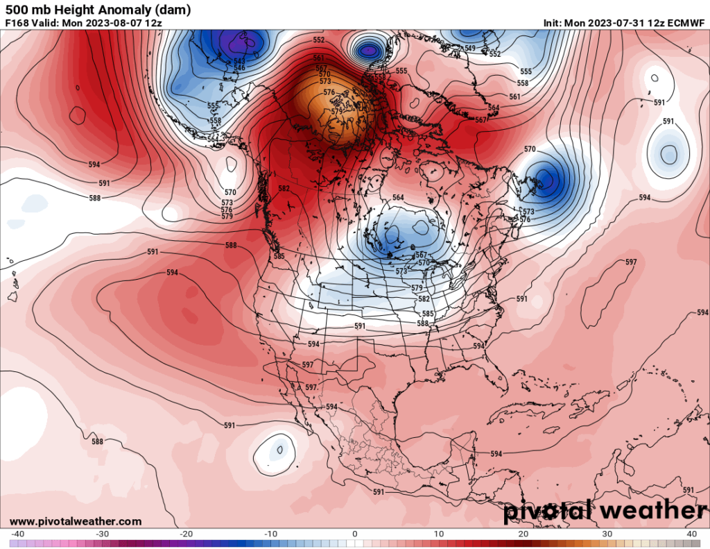
Going into next week there are signs that Heatwave Chevron will retrograde into the Southwest and intensify there:
For more details, here is a new Washington Post article from Dan Stillman:
Endless-seeming heat wave to keep broiling the southern U.S. this week
Record heat is forecast in Dallas, Houston and New Orleans, while Phoenix’s record-long streak at or above 110 degrees may finally end

By Dan Stillman
Updated July 31, 2023 at 2:28 p.m. EDT|Published July 31, 2023 at 1:16 p.m. EDT
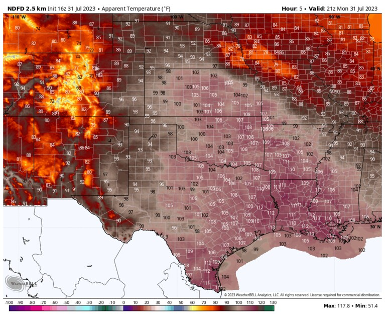
Heat index forecast for Monday afternoon. (WeatherBell.com)
The endless summer heat wave in the southern United States, now entering its third month, continues this week, scorching millions of Americans with record heat and high humidity. While portions of the Desert Southwest will see the searing heat ease ever so slightly early this week, it’s getting hotter along the Gulf Coast, especially in Louisiana and central to eastern Texas.
How Bad Is Heat Risk Near You?
 (The Washington Post)
We’re tracking dangerous heat waves across the United States daily. Look up your city to see extreme heat risks near you.
The week’s dangerous heat will focus on the Central and Southern Plains, the Lower Mississippi Valley and the Gulf Coast states where heat alerts were in effect Monday for more than 55 million people. Excessive heat warnings were issued for areas expecting the most extreme heat and humidity, covering northeast Texas, including Dallas; northern and southeast Louisiana, including New Orleans; southwestern Mississippi; and southeast Kansas.
New Orleans, a city accustomed to punishing levels of heat and humidity, could see some of its most extreme conditions on record with heat indexes over 115 degrees. Much of Texas, which is enduring a historically hot month, will roast for yet another week. According to The Washington Post’s heat tracker, Austin and Dallas will be the nation’s two hottest large cities this week, with heat indexes near or above 105 degrees all week.
“These temperatures and heat indices will pose a health risk to those without an effective cooling method and/or adequate hydration,” the National Weather Service said. “It is essential to have ways to cool down and limit your heat exposure.”
Numerous heat records, both for hot daytime high temperatures and warm nighttime lows, have fallen during the heat wave and more are expected this week. Dallas, Houston, San Antonio and Austin are all forecast to challenge records Monday and Tuesday.
Slight, but temporary break in the heat for Desert Southwest
The zone from Arizona to West Texas is seeing its first slight break in the heat since June, although it probably won’t last long.
In El Paso, the 44-day streak of days reaching 100 degrees or higher ended when Sunday maxed out at 97 degrees. The previous longest streak was 23 days in 1994. A new streak of triple-digit temperatures could begin by midweek.
The heat is finally relenting just a bit in Phoenix. Its streak of days climbing to 110 degrees or higher could end at 31 days, shattering the previous record of 18 straight days in 1974, if Monday’s high only reaches around 108 as forecast. Highs are forecast to be around 105 to 108 through Wednesday, but could climb to 110 or higher again starting Thursday.
In Las Vegas, the past two weeks have been hotter than any other 14-day stretch on record, with an average high of 112 degrees and average low of 89. Forecast highs this week are around 100 to 105, but could trend hotter again by the weekend.
Relentless heat continues for much of Texas
Texas has barely seen the heat let up all summer, and for most of the state, there’s no relief in sight this week.
Houston will continue to see highs near 100 through the weekend and heat indexes near or over 105. In Austin, high temperatures are predicted to reach near 105 all week and this weekend. The city has reached 100 degrees or higher on 23 consecutive days and could tie or break the record of 27 straight days set in 2011. The heat has even prompted a water park near Austin to dump ice into the water to keep guests cool.
Around Dallas-Fort Worth and Waco, forecast highs are around 105 to 107 all week and this weekend, with no rain in the forecast until at least the end of the weekend. The hot, dry and breezy conditions have elevated the fire threat along and west of Interstate 35. Waco hasn’t recorded measurable rain for 43 straight days, seven days short of the record 50-day rainless streak in 2015.
Especially hot and humid in Louisiana
New Orleans and Baton Rouge are bracing for highs in the upper 90s to near 100 all week and this weekend. Extremely high humidity could push heat indexes as high as 115. Both cities could tie or break the record high for the date each day, while New Orleans could crush its previous record of three straight days reaching 99 degrees or higher.
“The first half of this workweek will just be brutal,” the National Weather Service in New Orleans said. “Please take precautions to stay safe from the heat and be sure to check on those who are more vulnerable, too.”
Will the heat ever end?
Eventually, yes, but it may not be anytime soon. The heat dome responsible for the prolonged and punishing heat developed in June. While it has expanded and contracted, persistent and intense heat has centered on a zone stretching from Arizona to Florida, and it should continue to do so during the next few weeks.
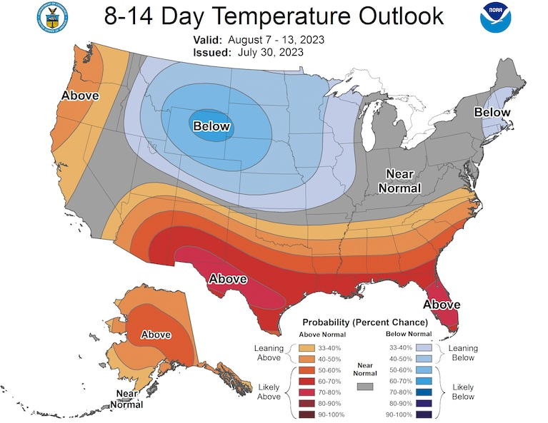
The Climate Prediction Center’s eight-to-14-day outlook for Aug. 7 to 13 calls for a high chance of temperatures well above normal across most of the nation’s southern tier.
Jason Samenow contributed to this report.
More on extreme heat
Our warming climate: Heat waves are ramping up the global burning of fossil fuels, asJuly will be Earth’s hottest month on record.Here’s why the sweltering heat wave isn’t moving anytime soon. At Earth’s hottest spots, heat is testing the limits of human survival. Use our tracker to see your city’s extreme heat risk. Take a look at what extreme heat does to the human body.
How to stay safe: It’s better to prepare for extreme heat before you’re in it. Here’s our guide to bracing for a heat wave, tips for staying cool even if you don’t have air conditioning, and what to know about animal safety during extreme heat. Traveling during a heat wave isn’t ideal, but here’s what to do if you are.
Understanding the science: Sprawling zones of high pressure called heat domes fuel heat waves. Here’s how they work. You can also read more about the link between weather disasters and climate change, and how leaders in the U.S. and Europe are responding to heat.
By Dan Stillman Dan Stillman is a meteorologist and editor for the Capital Weather Gang. He earned an M.S. in Meteorology from Texas A&M University, and a B.S. in Atmospheric, Oceanic and Space Sciences from the University of Michigan. Twitter
Here are some other “ET’s” recorded from around the planet the last couple of days, their consequences, and some extreme temperature outlooks, as well as any extreme precipitation reports:
Here is more climate and news from Monday:
(As usual, this will be a fluid post in which more information gets added during the day as it crosses my radar, crediting all who have put it on-line. Items will be archived on this site for posterity. In most instances click on the pictures of each tweet to see each article. The most noteworthy items will be listed first.)