The main purpose of this ongoing blog will be to track planetary extreme, or record temperatures related to climate change. Any reports I see of ETs will be listed below the main topic of the day. I’ll refer to record temperatures as ETs (not extraterrestrials).😉
Main Topic: Welcome Pattern Change to Usher in Fall Temps and Tropical Protection for Eastern U.S.
Dear Diary. I have some great news for a change today. As warm as the planet has become during 2023, the climate still has not become so broken that a weather system can’t produce cooler than average temperatures for at least a couple of weeks across a given portion of Earth. The eastern half of the United States will soon see such a welcome change late this week after experiencing yet another “late fall” due to effects from climate change.
We will go from a heat dome pattern that has produced numerous records across the eastern half of the United States and Canada:

To one which actually might produce some record chill in areas that will see record warmth in the 80’s in the Northeast and Canada today:

A bonus from the pattern change will be protection from strong organized tropical systems, probably all the way through the remainder of October. Remember Hurricane Michael? That October 2018 CAT 5 Hurricane devastated portions of the Florida Panhandle and South Georgia. Remember Hurricane Sandy from 2012? That system devastated much of the Northeast in late October of that year. Many forecasters and climatologists contend that it would not have come as far west as the northeastern U.S. if it wasn’t for the effects of climate change. Michael also would not have been as strong if it weren’t for late season record heat ahead of the system occurring over the southeastern U.S. during October 2018.
Many in the climate and weather world have been astounded of record warm Gulf and Atlantic waters this year, fearing that they could lead to more late season tropical monsters affecting the U.S. While we can’t entirely rule one out a U.S. landfall going into November, at least this coming pattern change will afford the U.S. much needed protection via ushering southward and eastward dry cool air, jet steering currents that deflect systems away from the U.S. mainland, and jet steam winds that shear apart any systems that will try to organize.
Here are more details on the weather pattern transition from Matthew Cappucci:
A strong fall front is marching east, bringing storms and tropical trouble – The Washington Post
Fall front sweeping across U.S. to drop temperatures by up to 40 degrees
After delivering severe weather to the Plains, the front might draw former Tropical Storm Philippe toward Maine and the Canadian Maritimes this weekend

Updated October 4, 2023 at 12:15 p.m. EDT

The cold front’s position on Wednesday morning. (NOAA/WPC)
The week began with record-breaking warmth over the northern Plains, Upper Midwest and much of the Great Lakes, but a strong autumn cold front is bringing a major change-up of the seasons. A shot of cool air from Canada is descending over the Lower 48, kicking up severe storms and heavy rainfall over the southern United States as temperatures plummet by as much as 40 degrees in some areas.
Across the nation’s heartland, the battling seasons will bring the risk of flooding rains and windstorms, along with large hail and a few tornadoes in Texas.
The same front will arrive in the Northeast late in the week, interacting with Tropical Storm Philippe as it transitions into a nontropical storm. Heavy rain and gusty winds are possible in portions of northern New England and Maritime Canada.
Thereafter, the pattern looks to favor continued cool weather over the eastern United States, with a renewed warm-up over the western and central states deeper into October.
Fall feel replacing record warmth
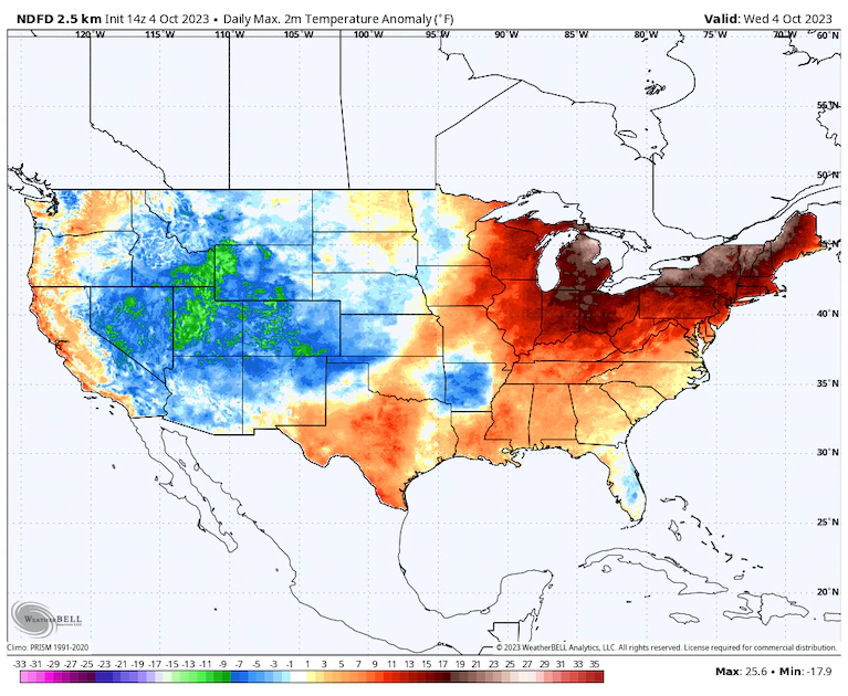
High temperature differences from normal Wednesday as predicted by the National Weather Service. (WeatherBell)
The calendar flipped to October amid record-high temperatures over the Corn Belt, Upper Midwest and Great Lakes, while extending north into Canada. Some of the heat expanded into the Northeast on Tuesday.
On Sunday, Sioux City hit a staggering 97 degrees, tying the Iowa October record. Minneapolis climbed to 92 degrees, beating its previous October record by 2 degrees. Across the central and southern Plains, highs in the 90s were widespread.
International Falls, Minn., near the Canadian border, had a record-tying high of 87 degrees on Monday, and a number of sites in Minnesota and North Dakota never fell below 70 degrees. Sault Ste. Marie, Mich., hit 83 degrees, its highest October temperature on record.
On Tuesday, record-challenging highs in the 80s stretched from eastern Minnesota to New York state; Duluth and Albany set record highs of 82 and 85 degrees, respectively. The National Weather Service predicts record highs on Wednesday from northern Michigan to Vermont, with forecast highs in the mid-to-upper 80s. Alpena, Mich., Buffalo and Burlington, Vt., are forecast to set records.
But a cold front is surging east. As of Wednesday morning, it stretched from the Permian Basin and Big Bend of West Texas to the Oklahoma-Texas border to near Kansas City to Madison, Wis. It had already blown through Minneapolis, but the coldest air is lagging several days behind the front; while highs should peak in the 60s on Wednesday and Thursday, the Twin Cities won’t make it out of the mid-50s on Friday and Saturday.
The same is true in Sioux City. After several days in the 90s, Friday’s highs should be only in the mid-50s. And even Sioux Falls, S.D., which made it to a record 93 degrees on Monday, shouldn’t climb above 51 degrees on Friday.
A cool high-pressure system from Canada will settle over the eastern Lower 48 into this weekend but should push east beginning Sunday. Winds on the backside of the clockwise-spinning high will turn southerly, reintroducing a warmer air mass over the Plains early next week.
Severe storms over the Plains
Storms erupted along the cold front across the Plains on Tuesday, bringing hail up to baseball size in Kansas. Osborne, Kan., also reported a wind gust to 80 mph, while Fairbury, Neb., gusted to 82 mph.
More storms are in the offing on Wednesday. A Level 3 out of 5 enhanced risk of severe weather was drawn by the National Weather Service Storm Prediction Center and includes portions of the Red River Valley along the southwest Oklahoma/north-central Texas border. The southern suburbs of Oklahoma City are in the bull’s eye, which stretches southwestward toward Lubbock and encompasses Lawton-Fort Sill and Wichita Falls.
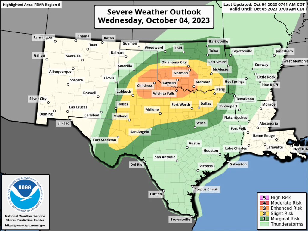
The Storm Prediction Center’s outlook for severe thunderstorms on Wednesday. (NOAA/SPC)
The main concern will be large, destructive hail up to egg size with initial rotating thunderstorms that form. That threat will transition to damaging straight-line winds as storms merge into the evening hours and collapse southeast toward the Dallas-Fort Worth area. Both Dallas and Oklahoma City are under a Level 2 out of 5 slight risk. An isolated tornado can’t be ruled out.
Dallas could also be at risk of flooding rains, particularly given how poorly the city’s impermeable surfaces handle heavy rainfall. Rainfall rates of 1 to 2 inches per hour could accompany Wednesday evening’s squall line.
Philippe to become a weekend concern as it interacts with front

Tropical Storm Philippe as seen on Wednesday morning. (Tropical Tidbits)
The front will not only trigger severe weather in central states but may also interact with former Tropical Storm Philippe this weekend, drenching parts of Maine.
On Wednesday morning, Philippe was located 200 miles north-northwest of St. Thomas, or 770 miles south of Bermuda. It had 45 mph winds and was drifting north-northwest at 7 mph.
Philippe has lived its life confusingly, defying forecasts and progressing much farther west in the Atlantic than initially predicted, bringing flooding to parts of the northern Leeward and Virgin islands. Now, meteorologists are calling for the storm to turn north — bringing tropical storm conditions to Bermuda on Friday — before undergoing “extratropical transition” and becoming a “post tropical” storm over the weekend. By then, it will begin deriving energy from the jet stream.
Tropical Storm Philippe forecast track:
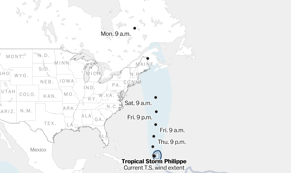
The cold front sweeping toward the East Coast should draw post-tropical Philippe toward Maine and/or the Canadian Maritimes over the weekend, by which point it should have winds in the 50-to-60-mph range. While the storm’s long-term path is uncertain, heavy rains and gusty winds are a good bet in Maine as well as Nova Scotia and New Brunswick, with effects not unlike those seen during Tropical Storm Lee but probably somewhat less intense.
Atlantic hurricane season has slowed, but beware of October
The storm is forecast to curl northwestward over Quebec early next week, and its rain could help extinguish still-burning wildfires.
By Matthew Cappucci Matthew Cappucci is a meteorologist for Capital Weather Gang. He earned a B.A. in atmospheric sciences from Harvard University in 2019, and has contributed to The Washington Post since he was 18. He is an avid storm chaser and adventurer, and covers all types of weather, climate science, and astronomy. Twitter
Here are some other “ET’s” recorded from around the planet the last couple of days, their consequences, and some extreme temperature outlooks, as well as any extreme precipitation reports:
Extreme heat today in the Canary Islands up to 40.5C at Frontera (Hierro Island). [map by AEMET]
— Extreme Temperatures Around The World (@extremetemps) October 4, 2023
Yesterday another record in Spain with 33.6C at Albacete.
A new warm spell will sweep Europe with potential record breaking conditions specially in UK and Ireland.
Stay tuned. pic.twitter.com/EkxKAM2eCx
Never ending record heat in North Africa and Middle East
— Extreme Temperatures Around The World (@extremetemps) October 4, 2023
Today an exceptionally late 46.0C at Swiehan in the Emirates and almost 43C at Al Ain
In Sahara yesterday 42.4C at El Aioun ,Atlantic coast, pulverizes the October record
In Cape Verde warmest nights on records up to 27.7C pic.twitter.com/qp6qP5bKkR
Wild weather in #Australia.
— Extreme Temperatures Around The World (@extremetemps) October 4, 2023
Incredible heat in the SE, despite October is starting , monthly records of highest Tmins are being broken.
Severe rainfalls too: see details below of temperatures and rainfall records broken. https://t.co/t2UpD8q4fs
Exceptional heat in #China,dozens of monthly records are falling in several provinces with temperatures up to 38C
— Extreme Temperatures Around The World (@extremetemps) October 4, 2023
Among them,Luodian in Guizhou,Panzhihua,Yanbian and Batang in Sichuan,Mangkang in Tibet,Yongren,Yaoan and Zhanyi in Yunnan
See list courtesy of meteorologist "Xinxin" pic.twitter.com/zXGGpAY2sB
Record heat US/Canada
— Extreme Temperatures Around The World (@extremetemps) October 4, 2023
88F Presque Isle
83F at Sault St Marie
Canada 32.2C/90F at Lagoon City and dozens of records broken including 30.9C Ottawa-see list of highest Temp 👎
Record warm nights:Tmin 20.3C Fort Frances
1 October 97F Sioux City AP TIES IOWA HOTTEST OCTOBER DAY pic.twitter.com/owYSwYLOW9
Burlington Vermont has posted its hottest October day on record joining Minneapolis, Sioux City, Ia. and Sault Ste. Marie, Mich, among others, which have accomplished this feat this week. https://t.co/vpfbHSxkYw
— Capital Weather Gang (@capitalweather) October 4, 2023
Wednesday 2:22 pm: Just Because Department: 86F as far north as Moosonee, Ontario on the shore of James Bay. Hottest temperature on record for and October day (84F was previous record). Average high this time of year is ~53F. pic.twitter.com/bPr9vZ2VAw
— Richard Heatwave Berler (@HeatwaveKGNS) October 4, 2023
Here is some more new September 2023 climatology:
September 2023 in #Poland was exceptional:
— Extreme Temperatures Around The World (@extremetemps) October 4, 2023
Temperature anomaly was a whopping +4.0C above the 1991-2020 normal and was the warmest September on records,beating 1866. https://t.co/n3w5rfxSDh
September 2023 in @Sweden was very warm with temperature anomalies between +1.5C and +3.5C above average.
— Extreme Temperatures Around The World (@extremetemps) October 4, 2023
It was wet in the North with record snowfalls and drier than average in the South.
Maps by SMHI. pic.twitter.com/LsMgBBB85M
September 2023 in #Norway had a temperature anomaly of +1.8C above average and was the 5th warmest on records.
— Extreme Temperatures Around The World (@extremetemps) October 4, 2023
44 records of monthly highest temperatures were broken including a national record with 28.3C.
Precipitations were 35% above normal. https://t.co/Mt1k8es27p
September 2023 both in the South Pole and Vostok were way above average with anomalies of +2.4C and +2.1C.
— Extreme Temperatures Around The World (@extremetemps) October 4, 2023
The month started cold and turned much warmer than average. https://t.co/5h8uvXx7c8
#Arctic air temperature rank by month over the satellite era – now updated through September 2023…
— Zack Labe (@ZLabe) October 4, 2023
+ Ranks: 1=warmest (red), 44/45=coldest (blue)
+ Download visual: https://t.co/QEaNIX4OBe pic.twitter.com/KVaFLl0lkb
Here is More Climate and Weather News from Wednesday:
(As usual, this will be a fluid post in which more information gets added during the day as it crosses my radar, crediting all who have put it on-line. Items will be archived on this site for posterity. In most instances click on the pictures of each tweet to see each article. The most noteworthy items will be listed first.)
Great video makes clear that Stanford is subcontracting 'sustainability' education to Big Oil.
— Bill McKibben (@billmckibben) October 4, 2023
A 'fireside chat' with the ceo of Exxon….. https://t.co/bMmwZvEp9Q
Pope urges rich world to make profound changes to tackle climate crisis https://t.co/RBA3IInjDS
— Guardian Environment (@guardianeco) October 4, 2023
I keep trying to point out the massive area of open water on the western side of the #Arctic right now. This is very much reflected in looking at last month's sea-ice concentration anomalies…
— Zack Labe (@ZLabe) October 4, 2023
Data from https://t.co/ydZwSgdVlI. Concentration = fraction of sea ice in a location. pic.twitter.com/JDlBEppJdv
The Pope has issued a blistering, lengthy attack on climate deniers – and what needs to happen at COP28
— Leo Hickman (@LeoHickman) October 4, 2023
"a broad change in the irresponsible lifestyle connected with the Western model would have a significant long-term impact"https://t.co/BBNsrex4f6 pic.twitter.com/GB2XxQfW1M
A big project I've been on: NPR's first Climate Solutions Week. From the Philippines to north India to Uruguay to San Jose, CA, it's about the agency and ingenuity people have shown–just regular people–in coping with a hotter planet. Feedback welcome. https://t.co/1x0W4UOW5p
— Neela Banerjee (@neelaeast) October 3, 2023
"The Science & Morality of Climate Change: A Conversation on Our Relationship to Life on Earth" | #OurFragileMoment conversation and book-signing (courtesy of @SeminaryCoop bookstores) at the @ChiHumanities Fall Festival, Sat Oct 21 in Chicago: https://t.co/wQIctxpPcK
— Prof Michael E. Mann (@MichaelEMann) October 4, 2023
Temperatures during the last few months have been frankly… crazy.
— Dr. Robert Rohde (@RARohde) October 4, 2023
A confluence of man-made and natural factors is currently making an extreme anomaly.
But you should also see it as a preview of what could become normal weather with another decade or two of global warming. https://t.co/4D6MOHpb3D
In case you missed it yesterday, you can view the full recording of my live discussion of our new research on prescribed fire and climate change in the American West. A bonus for late-comers: embedded links to paper and blog! #CAwx #CAfire #CAwater https://t.co/NBySZmg4Iy
— Dr. Daniel Swain (@Weather_West) October 4, 2023
Researchers call for urgent emissions cuts as Antarctic sea ice 'drops off a cliff' https://t.co/ob464M4WgV
— Julian Cribb (@JulianCribb) October 4, 2023
Watch @bob_moritz, Global Chair @PwC, talk about the importance of building a trusted society that drives climate action and motivates others to tackle climate change. https://t.co/6xtLHFjQWD
— Climate Group (@ClimateGroup) September 20, 2023
Today’s News on Sustainable, Traditional Polluting Energy from Fossil Fuel, and the Green Revolution:
Great video makes clear that Stanford is subcontracting 'sustainability' education to Big Oil.
— Bill McKibben (@billmckibben) October 4, 2023
A 'fireside chat' with the ceo of Exxon….. https://t.co/bMmwZvEp9Q
Mexico built a #solar farm to power 1.3 million homes setting a world record by installing 18,990 #solarpanels in a single day.
— Mike Hudema (@MikeHudema) October 4, 2023
We have solutions to the #climatecrisis. The only thing missing is the political will to implement them. #ActOnClimate #climate #renewables pic.twitter.com/ygsF5yaHiA
More from the Weather Department:
Typhoon Koinu just slammed into Orchid Island, Taiwan, where a wind gust of 213 mph (342 km/h) was reported.
— Colin McCarthy (@US_Stormwatch) October 4, 2023
If confirmed, this would be one of the top 5 highest wind gusts ever recorded on Earth. pic.twitter.com/9yyowuA0g3
Typhoon 🌀 Koinu going to spin over extreme southern Taiwan 🇹🇼 then to head toward Eastern China 🇨🇳 and will impact Shantou to Hong Kong. Be safe in this big system! pic.twitter.com/rktCJ4MSQG
— James Wilson (@tornadokid3) October 4, 2023
#ICYMI Our latest ENSO blog dives into how this year's robust El Niño could impact winter weather and climate across North America. https://t.co/DWJHHyfRpD pic.twitter.com/onnXbkyio3
— NOAA Climate.gov (@NOAAClimate) October 4, 2023
More on the Environment:
Alaskan boglands in full glory. Peatlands cooled our climate by taking up and storing carbon from the atmosphere. We need to respect and protect them as climate heroes. Please share for awareness. pic.twitter.com/WpNDcsRojY
— Dr. Merritt Turetsky (@queenofpeat) October 4, 2023
Drinking water supplies are decimated in communities south of New Orleans as the Mississippi River is overwhelmed by salty Gulf of Mexico waters pushing north. https://t.co/u4KZ7xwZsJ
— Rocky Kistner (@therockyfiles) October 4, 2023
More on Other Science and the Beauty of Earth and this Universe:
This video of an octopus changing colors in her sleep might be an indication she's dreaming.
— Mike Hudema (@MikeHudema) October 4, 2023
Nature is amazing. Protect it.#ActOnClimate #climate #biodiversity #rewilding #protectTheOceans pic.twitter.com/uv7aelDSZZ