The main purpose of this ongoing blog will be to track extreme, or record temperatures related to climate change. Any reports I see of ETs will be listed below the main topic of the day. I’ll refer to extreme or record temperatures as ETs (not extraterrestrials).😉
Main Topic: Australia Roasts from Their First Summer Heatwave
Dear Diary. As early as nine months ago due to El Niño, Australia was forecast to have a much hotter than average summer. This would be on top of anomalous heat climate change would probably have brought to the island continent. Right on que at the beginning of the Southern Hemisphere meteorological summer we have a strong heat dome over Australia centered on New South Wales:
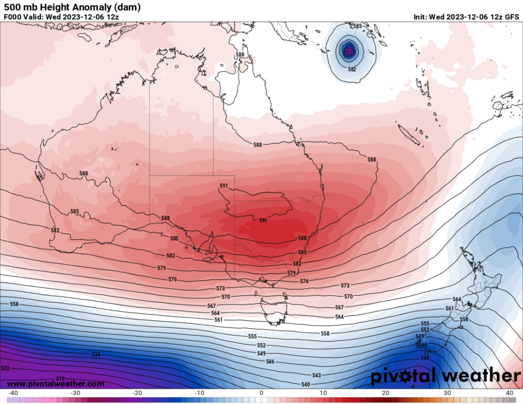
🌡️ #NSW #Heatwave is ramping up and extending gradually east. Currently rated Severe over much of the inland as daytime temperatures reach into the 40s.
— Bureau of Meteorology, New South Wales (@BOM_NSW) December 6, 2023
See warning details at https://t.co/zKDGvCXmft
and consult #NSWHealth for community advice in the heat. pic.twitter.com/rQ2Yp3fweH
AUSTRALIA HEAT WAVE
— Extreme Temperatures Around The World (@extremetemps) December 6, 2023
Exceptional heat with temperatures 44C+ in 5 States:
46.4 in South Australia (at Marree)
45.7 Western Australia
44.8 New South Wales
44.7 Queensland
43.9 Northern Territory
It can get even worse next 2 days. https://t.co/wO2TCGDJLG
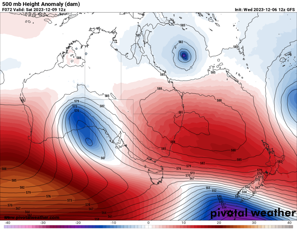
A cold front should bring relief to southwestern and southcentral Australia in a couple of days, but very hot conditions with maxes near or above 40°C/104°F should persist in the east through this week:
For more detail here is an article from the Guardian:
Heatwave to spread across Australia this week with 40C temperatures expected in some areas
Extremely hot weather not expected to break records but half the country can expect unrelenting high temperatures, especially SA and WA
- Follow our Australia news live blog for latest updates
- Get our morning and afternoon news emails, free app or daily news podcast
By Emily Wind
Tue 5 Dec 2023
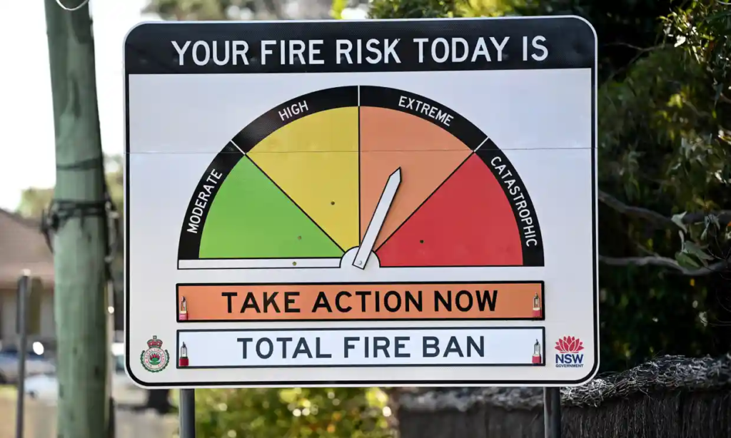
Heatwave conditions in much of Australia this week are likely to push the bushfire risk into the red zone, including in Queensland and NSW. Photograph: Dan Himbrechts/AAP
Half of Australia will be blanketed in a widespread heatwave by the end of this week, enduring days of high temperatures with little reprieve.
A cool change will begin making its way across the country at the weekend but high temperatures will continue for much of inland New South Wales.
The Bureau of Meteorology’s three-day heatwave map shows that until Thursday, an extreme heatwave is likely at the South Australia and Western Australia border, and through parts of the Kimberley.
For Wednesday to Friday the temperature map shows a low-intensity heatwave spreading across large swathes of the country – from Broome in WA across parts of the Northern Territory, South Australia and Queensland, and east to Canberra and Sydney.
Severe heatwave conditions will also be felt across these states but will be concentrated in most of NSW, all of inland South Australia and southern Queensland.
A BoM senior meteorologist, Miriam Bradbury, said remote parts of SA and WA were feeling the heat on Wednesday, with some locations expected to reach at least 40C, “if not pushing towards the mid to high 40s”.
These high-40 temperatures were already beginning to spread into northwestern NSW and southern Queensland on Wednesday.
“We do measure [heatwaves] over a three-day period because one hot day most people can manage but it’s when it’s persistent for days on end that it starts to get really intense,” Bradbury said.
The hot conditions in NSW and Queensland will intensify over the coming days, with severe heatwave conditions reaching the east coast by the end of the week – across parts of Sydney, the Illawarra and Newcastle.
Bradbury said temperatures in these areas will reach the low 30s before pushing into the high 30s and low 40s by Friday.
Capital cities are expected to avoid the worst of the heatwave, with rural and remote areas to be hit hardest.
The BoM isn’t expecting any temperature records to be broken. Bradbury explained that while a hot summer day brings spikes in temperatures, a heatwave is more about days of unrelenting heat.
She said people may see a temperature reading in the late 30Cs and think “you know, last summer we had a 42-degree day and we managed” but the difference was that this heat would persist.
“It just takes a real toll on the body and the health system, and you can’t recover overnight because the nights themselves are sitting in the mid 20s,” she said. “There’s no recovery period, which really does take a toll.”
A cool change is expected to reach southern WA on Friday. This will shift temperatures to below-average, and sweep across much of SA, Victoria, Tasmania and south-west NSW on Saturday.
In SA, Woomera is set to drop from 46C on Friday to 24C on Saturday.
In the outback NSW town of Broken Hill, temperatures are forecast to fall from 43C on Friday to 33C on Saturday, while Penrith in western Sydney will fall from 42C on Saturday to 28C on Sunday.
The cool change won’t come to all of NSW. Bradbury said the heat could persist until early next week.
“There is some relief for coastal parts but inland parts of the state [will] really, really [struggle] to cool,” she said. “They might be going from the low 40s on Saturday and Sunday back to the high 30s early next week, so very little relief.
“We do expect those heatwave conditions to persist through NSW into next week, even as they ease in other parts of the country.”
The BoM is expecting some showers and possible thunderstorms as the cool change moves across the country from the weekend. This is expected to reach Victoria, Tasmania and south-east SA from Friday.
Patchy showers may hit the NSW coast at the weekend before the cool change but rainfall totals will be fairly low compared with last week’s heavy rain, Bradbury said.
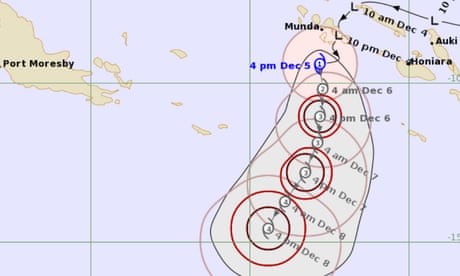
Tropical cyclone Jasper has formed over the Coral Sea, with the potential to reach the Queensland coast at the weekend or early next week.
The cyclone, which is moving away from the Solomon Islands, is expected to reach category three this evening and intensify to category four late on Thursday.
The BoM said the highest risk area was in the region north of Mackay, with alerts to be issued when it reached the coast.
Here are more “ET’s” recorded from around the planet the last couple of days, their consequences, and some extreme temperature outlooks, as well as any extreme precipitation reports:
Records are falling allover Asia every single day from Indonesia to Saudi Arabia.
— Extreme Temperatures Around The World (@extremetemps) December 6, 2023
MINIMUM Temps. >28C in MALDIVES,27C in Saudi Arabia
36.4C at Bangkok THAILAND,records in INDIA 36.6C Madurai AP, 34.3C Minicoy Island
37C in Myanmar.
25C in Central Asia, +10C in Siberia! Insane. pic.twitter.com/249Ep6Pagv
Very high temperatures today in #Alberta & #Saskatchewan 🇨🇦, near records for early December.
— Thierry Goose (@ThierryGooseBC) December 6, 2023
AB
18.6°C Bow Island
18.2°C Irvine
18.0°C Etzikom & Medicine Hat
17.9°C Pakowki Lake
17.5°C Foremost
17.3°C Claresholm
17.2°C Fincastle
17.0°C #Calgary
SK
18.0°C Maple Creek#ABstorm pic.twitter.com/xmqfYV7JbN
Relentless Record heat in Southeast Asia:
— Extreme Temperatures Around The World (@extremetemps) December 6, 2023
Today the MINIMUM temperature at Roxas in the PHILIPPINES was 27.8C a new record for December and 0.1C from the National record of December highest minimum temperature. pic.twitter.com/5NQ2cSklXX
More and more records in the MALDIVES.
— Extreme Temperatures Around The World (@extremetemps) December 6, 2023
Today Hanimadhoo rose to 34.6C HIGHEST DECEMBER TEMPERATURE IN MALDIVEAN HISTORY.
That's after beating its November highest minimum,highest maximum and December highest minimum. https://t.co/T2r0E8WmKc
Here is more new November 2023 climatology:
According to ERA5 reanalysis, November 2023 was the 2nd least snowy November since 1940 in the Contiguous U.S. pic.twitter.com/E2LTaDBT3M
— Brian Brettschneider (@Climatologist49) December 7, 2023
November temperature highlights from #CopernicusClimate Change Service. Last month:
— Copernicus ECMWF (@CopernicusECMWF) December 6, 2023
🌡 was the warmest November on record globally 0.85°C above average
🌡 average sea surface temperature over 60°S–60°N was the highest on record for November at 0.25 °C
👉 https://t.co/hVcTtHnTRN pic.twitter.com/tu1MaKUoQl
November 2023 in the #Philippines was a record warm month.
— Extreme Temperatures Around The World (@extremetemps) December 6, 2023
In particular, night temperatures remained at record level the whole month throughout the country.
It was very dry in the North and normal rainy in central/Southern areas.
Maps by Pagasa. pic.twitter.com/U0p7v1OpvN
November 2023 in #Romania was warmer than normal in the East (up to -2C) and normal in the West with some scattered negative anomalies (left).
— Extreme Temperatures Around The World (@extremetemps) December 6, 2023
It was very rainy from normal to +300% more than normal. (right map).
Maps by Meteo Romania pic.twitter.com/EddsVgvSvE
November 2023 in #Moldova had temperature anomalies between +2C and +3C above normal.
— Extreme Temperatures Around The World (@extremetemps) December 6, 2023
It was dry in the North and very wet in the South with precipitations anomalies 45% to 375% of normal.
Maps by SHS. pic.twitter.com/EEr5dAeVNL
November 2023 in Croatia had temperature anomalies between +0.1C and +2.2C above average.
— Extreme Temperatures Around The World (@extremetemps) December 6, 2023
It was also very wet except in Lestovo (37% of normal) with precipitation totals up to 220% of normal in the East.
Maps by DHMZ. pic.twitter.com/iwE8n6cM0G
November 2023 in Serbia relative to 1991-2020:
— Milos Milic (@skomimaster) December 5, 2023
– temp. anomaly from -0.2C to +2.2C 🌡️
– % of normal precip. from 163% to 373% 🌧️
– the wettest November in Serbia since 1951 ☔️
– half of synoptic stations had 1st or 2nd wettest NOV
– record 38cm of snow for NOV in town Vranje pic.twitter.com/pg5XDsY8pX
November 2023 in #Kenya had an average temperature of 22.3C which is 0.5C below normal.
— Extreme Temperatures Around The World (@extremetemps) December 6, 2023
It was a very rainy month,with above average rainfall allover except in the Northwest,very wet on the coast after years of drought.
See rainfall anomalies map by Meteo Kenya. pic.twitter.com/I7M17xk0CN
November 2023 in New Zealand had an average temperature of 14.1C, +0.4C above normal (left)
— Extreme Temperatures Around The World (@extremetemps) December 5, 2023
26.4C Whangaparāoa and 29.7C Waikeria were new their monthly heat records
Most of the country was dry except the Northeast with locally 2/3 times the normal rainfalls (right)
Maps by NIWA pic.twitter.com/ZUl7Q63N7A
Carbon dioxide (CO₂) averaged about 420 ppm in November 2023
— Zack Labe (@ZLabe) December 6, 2023
10 years ago November averaged about 395 ppm
+ Preliminary data (@NOAA_ESRL): https://t.co/81JQavZVWZ pic.twitter.com/G1Zzcsygi4
We just observed the warmest November on record for the global average temperature.
— Scott Duncan (@ScottDuncanWX) December 6, 2023
We can still find areas of extreme cold in a warming world. pic.twitter.com/fkHGHhDdod
Well November 2023 is now the 6th consecutive month of new global temperature records… not surprised sadly 🥴
— Zack Labe (@ZLabe) December 6, 2023
More info on November's climate summary from @CopernicusECMWF ERA5 data: https://t.co/IyMvdfbRXW pic.twitter.com/UkQar50ZrN
45 years of #Arctic sea ice thickness during the month of November. The trend is obvious.
— Zack Labe (@ZLabe) December 7, 2023
Graphic available at https://t.co/qXpJKsA27B pic.twitter.com/p6tKYflQvf
More news and notes from COP28:
Attendees at #COP28 are breathing in the pollution from fossil fuels that kills millions around the world each year. May it highlight the urgency of action not only for climate targets but also for the lives of real people today.
— The Real Prof. Katharine Hayhoe (@KHayhoe) December 6, 2023
From @GernotWagner pic.twitter.com/Ibl9y1RoaM
Did you know? Indigenous Peoples safeguard an estimated 80% of the world's biodiversity.
— UN Climate Change (@UNFCCC) December 5, 2023
🦜🐞🌳🐟
Day 6 at #COP28 focused on Indigenous Peoples and the important role they play for climate action. pic.twitter.com/YVhsqUFoqL
Vanessa still doing an excellent job.
— Alex Hale 🌒 (@NBPTROCKS) December 6, 2023
💚✊🪧 https://t.co/wzirNHt6aX
🌊 Ocean warming and melting 🧊 ice sheets and 🏔️ glaciers all contribute to overall rise.
— World Meteorological Organization (@WMO) December 6, 2023
📊 Between 2011-20, sea levels rose at a rate of approximately 4.5mm/yr. This is the #StateOfClimate. These insights are pivotal for deliberations at #COP28.
📑https://t.co/zLJHllg4Pe pic.twitter.com/GkJMGZ6mji
"Lettre ouverte au nom du climat au Sultan Al Jaber: les lignes rouges ultimes pour la COP28" | Our (@JPvanYpersele & my) letter published (en francais) via @LeSoir: https://t.co/u3UUrzYVpo
— Prof Michael E. Mann (@MichaelEMann) December 6, 2023
There are 2,456 fossil fuel representatives at #COP28 – FOUR times higher than ever before -more than the 10 most vulnerable countries combined.
— Mike Hudema (@MikeHudema) December 6, 2023
The ones that got us into the problem and continue to profit from it aren't going to help us solve it.#ActOnClimate #emissionscap pic.twitter.com/hnyx3ShQhY
The world is – literally – on fire.
— Assaad Razzouk (@AssaadRazzouk) December 6, 2023
Either the #COP28 UN climate talks – with 1 week to go – deliver a timetable for a rapid and just (and entirely doable) phase-out of 95% of fossil fuels by 2035, or it will the year the rich few told the other 7 billion to go eat cake and fry pic.twitter.com/PnN6cLoYTk
Here is More Climate and Weather News from Wednesday:
(As usual, this will be a fluid post in which more information gets added during the day as it crosses my radar, crediting all who have put it on-line. Items will be archived on this site for posterity. In most instances click on the pictures of each tweet to see each article. The most noteworthy items will be listed first.)
There we have it.
— Brian McHugh 🌏🏳️🌈 (@BrianMcHugh2011) December 6, 2023
2023 warmest year in recorded history #ClimateCrisis#ClimateChange https://t.co/21JSwvTOAS
A major new report on climate tipping points was published today, produced by 200 researchers from 90 organisations in 26 countries.
— Prof. Stefan Rahmstorf 🌏 🦣 (@rahmstorf) December 6, 2023
Read the brief summary in the Guardian:
Earth on verge of five catastrophic climate tipping points, scientists warn https://t.co/GK0jzAN5C2
Important new report: Just as in the IPCC, it shows that if we go beyond 1.5, we enter a high-risk zone of crossing tipping points. We need to move fast to avoid moving to a point where the Earth system takes over & pushed us in a direction with unmanageable conditions. https://t.co/eOdrCQIEw0
— Johan Rockström (@jrockstrom) December 6, 2023
I'll be live in studio at 30 Rock talking about the #COP28 climate summit and #OurFragileMoment with the awesome @KatyTurNBC on @MSNBC @KatyOnMSNBC TOMORROW (Thurs) during the 3pm ET hour. Stay tuned for further details…https://t.co/CDPgXrsvfB
— Prof Michael E. Mann (@MichaelEMann) December 6, 2023
Here's a thread in pictures about the Atlantic overturning circulation #AMOC which is making headlines this week. I've studied this topic since 1991 and will show key data and models & some video.
— Prof. Stefan Rahmstorf 🌏 🦣 (@rahmstorf) July 28, 2023
Let's go: observed temperature trend since 1901 from https://t.co/jGHxmrjzLG 🧵1/x pic.twitter.com/TdnNt1OYeT
“A reversal of the current cooling trend in the E Pacific over the next few decades could lead to a period of global-mean warming with a 60% higher rate than currently projected. …destabilization of the shortwave cloud feedback to affect temperature…” https://t.co/IcaEyfkwek
— Jeff Berardelli (@WeatherProf) December 6, 2023
Why are temperatures so extreme in 2023? Over at The Climate Brink @AndrewDessler explores some of the potential drivers of this year's record temperatures, and comes away with more questions than firm answers: https://t.co/lfMPAFyLKJ
— Zeke Hausfather (@hausfath) December 6, 2023
“Tipping points in the Earth system pose threats of a magnitude never faced by humanity,” said Tim Lenton, from the University of Exeter’s Global Systems Institute. https://t.co/vRxkWbneIh
— David Wallace-Wells (@dwallacewells) December 6, 2023
Your 'moment of doom' for Dec. 6, 2023 ~ The Magic 8-ball says "f&%kery ahead!"
— Prof. Eliot Jacobson (@EliotJacobson) December 6, 2023
"We are now in a flat out race between tipping points. Will global society wake up and act before our impacts on the climate trigger devastating changes beyond our control?"https://t.co/q8L4vJzqPj
Its not just methane from melting perma frost on land we should be worried about
— GO GREEN (@ECOWARRIORSS) December 6, 2023
But also frozen methane on deep sea floor
Study finds climate change can cause frozen methane which is trapped as a solid under our oceans being released from the deep oceanhttps://t.co/5P25VblOuK
Revealed: How colonial rule radically shifts historical responsibility for climate change | @DrSimEvans @VernerViisas
— Carbon Brief (@CarbonBrief) December 6, 2023
Read here: https://t.co/2PIyVDLcqP pic.twitter.com/d45HigkGjD
Cyclone Freddy, the strongest tropical cyclone ever recorded, has devastated Malawi's small farmers.
— Yale Environment 360 (@YaleE360) December 7, 2023
Experts say that climate change could force Malawi into a constant state of response and recovery.https://t.co/mPmplSlwZm
“You would think the extreme events around the world would be sparking action but governments appear oblivious, somehow thinking treading water will deal with the flood of impacts.”
— Greenpeace International (@Greenpeace) December 6, 2023
Fossil fuel emissions are set to hit a record high in 2023.#COP28 https://t.co/sRjNkMS0A3
Watch till the end. Notice a pattern? Global temperature change – 1850 to June 2023. We're quickly spiralling out of control.
— Mike Hudema (@MikeHudema) December 6, 2023
No time to wait. #ActOnClimate #climate #energy #renewables #Cop28 pic.twitter.com/8IUgSgLe3I
Today’s News on Sustainable Energy, Traditional Polluting Energy from Fossil Fuel, and the Green Revolution:
Indian CO2 emissions are skyrocketing, across all fossil fuels.
— Glen Peters (@Peters_Glen) December 6, 2023
Even though India is deploying record solar & wind, it would seem coal use is accelerating.
Learn more about India here: https://t.co/erarnLSWcj
Figure from: https://t.co/1zWWaxSaTQ pic.twitter.com/dHZZRTvsi9
Analysis: Growth of Chinese fossil CO2 emissions drives new global record in 2023 | @hausfath @PFriedling
— Carbon Brief (@CarbonBrief) December 7, 2023
Read here: https://t.co/QAd9JVMt25 pic.twitter.com/Qo6jukZ06c
YES COLORADO YES https://t.co/gOGQPml2vA pic.twitter.com/jCvxabpu2e
— Hayden Clarkin (@the_transit_guy) December 6, 2023
“Is now the time to explore more oil and gas projects or is now the time to take action?” – @GreenpeaceAR Campaigns Lead Shady Khalil at #COP28 pic.twitter.com/slVSPPZ3zm
— Greenpeace International (@Greenpeace) December 5, 2023
The oil industry needs to:
— Ceres (@CeresNews) December 6, 2023
🌎Rapidly decarbonize its own operations
🔥Reckon with the unavoidable truth that it is the burning of fossil fuels that is driving the climate crisis.
Read more from @ALoganCeres:https://t.co/tRGvlQ61Gl #COP28UAE #Cop28
Downward: EVs already avoid 1.8 mbpd.
— John Raymond Hanger (@johnrhanger) December 6, 2023
That puts downward pressure on oil demand & price. Today, U.S. crude dropped ~4% with retail gasoline prices at lowest point since January."
WTI fell below $70, down $2.80. Brent fell too.https://t.co/2s0Z52wwPM
Credit @colinmckerrache pic.twitter.com/3jDSPyKZNA
Madrid is building 74km forest belt of half a million trees 🌳 around the city to fight extreme heat, air pollution & climate change.IPCC
— Mike Hudema (@MikeHudema) December 6, 2023
We have so many solutions. Implement them. #ActOnClimate #ClimateCrisis #climate #energy #renewables #biodiversity #IPCC #Cop28 pic.twitter.com/exkpD3GBnY
California is requiring all new homes to be built with #solar panels, all public buses to be zero emissions, & building massive batteries to provide 24 hr #renewableenergy.
— Mike Hudema (@MikeHudema) December 7, 2023
We have solutions, implement them. #ActOnClimate #climateaction #climate #energy #GreenNewDeal #Cop28 pic.twitter.com/sG2rmSc70O
More from the Weather Department:
The impressive rain and snowmelt has caused several rivers to flood. This is the Stillaguamish river showcasing flooding in Western Washington. Thankfully it has now crested and receding. But it hit the highest flood stage before coming down. More rain and snow still pic.twitter.com/6YhWxs9T7E
— Jordan Steele (@JordanSteele) December 6, 2023
The Stillaguamish River in Granite Falls, WA raging this afternoon. Heavy rain from the Atmospheric River has caused a rise in river levels #WAwx pic.twitter.com/kX3f88UilU
— WeatherNation (@WeatherNation) December 6, 2023
Still watching a big weather system this weekend. Radar here Saturday/Sunday showing heavy rains and possible snow to the north. Severe storms upper Gulf Saturday. Sneaky squall line into Florida and east coast Sunday to watch. https://t.co/Hk3pbO7x8H pic.twitter.com/Moew0JL0z4
— Mike's Weather Page (@tropicalupdate) December 6, 2023
⚠️ The potential for a widespread strong-to-damaging wind event is increasing along the U.S. eastern seaboard from Sunday into Monday 😬
— Ben Noll (@BenNollWeather) December 6, 2023
🟠+🔴+🟣 colors indicate where winds aloft (5000 ft) are forecast to reach 60 mph, potentially translating to severe gusts on the ground 🌬️ pic.twitter.com/krPSw1MYnc
The drought situation improves in 60 days, but the situation is still alarming: https://t.co/nKwoQE1dMG
— Jake Reyna (@iJakeReyna) December 6, 2023
Happy #IndependenceDay!
— Mika Rantanen (@mikarantane) December 6, 2023
The ice coverage in the Baltic Sea is off to a healthy start. The extent today was 39 000 km², the highest for this date in the 2007-2022 statistics.
The extent today is even higher than the overall maximum for the 2019-2020 winter (37 000 km²). pic.twitter.com/4MkqvjjYpW
More on the Environment and Nature:
The growing market for rubber is a major, but largely overlooked, driver of deforestation.
— Yale Environment 360 (@YaleE360) December 6, 2023
Experts warn the transition to EVs, which wear out tires faster than conventional cars, could intensify rubber demand.https://t.co/0mUqbJdr9M
A gorgeous Oak still hanging onto its leaves on the edge of South Belfast ❄️🍂.
— 🌳Magical Trees & Mythology🌳 (@ReWild_Belfast) December 6, 2023
Oak trees were once sacred in Rome. As they seem to have been in most other ancient European civilizations.
They were the sacred 🌳 of Jupiter, the King of the Gods with Roman Generals & Commanders… pic.twitter.com/9CqFUBjTV8
The urgency of reforestation worldwide:
— Green is a mission (@Greenisamissio1) December 6, 2023
Forest restoration, when implemented appropriately, helps restore habitats and ecosystems, create jobs and income and is an effective nature-based solution to climate change.💚🌱☘️🌿🌲🌳🍀💚 pic.twitter.com/Ot5edRhGUp
Marine heatwaves are becoming increasingly common as climate change accelerates. But now, scientists may have figured out a way to forewarn how these acute ocean warming events will affect whale and sea turtle habitats.https://t.co/XGx4M4ISXQ
— Inside Climate News (@insideclimate) December 6, 2023
Have you heard any pileated woodpeckers lately? As young are venturing off on their own, calls and drumming tend to increase as territories are established and defended!
— U.S. Fish and Wildlife Service (@USFWS) December 6, 2023
📷 Grayson Smith/USFWS pic.twitter.com/JxNIfj6gpf
Researchers find that pollution, through exposure to certain heavy metals, feminizes sea green turtle embryos, increasing their risk of extinction given the current lack of male hatchlings.
— Frontiers (@FrontiersIn) November 20, 2023
Explore the study in @FrontMarineSci: https://t.co/WS9jth1H3I, or our news story ⬇️
More on Other Science and the Beauty of Earth and this Universe:
What a breathtaking rainbow in Italy! 🌈😍 pic.twitter.com/QVRmLrTtLo
— AccuWeather (@accuweather) December 6, 2023
Did you know that the dandelion seed decides for itself where it lands? Rising air also carries water molecules, from evaporation, upwards. If there is enough moisture, the seed closes its umbrella and falls to the ground; if not, the umbrella remains open and the seed flies on💚 pic.twitter.com/DQFQ4maoub
— Green is a mission (@Greenisamissio1) December 6, 2023