The main purpose of this ongoing blog will be to track planetary extreme, or record temperatures related to climate change. Any reports I see of ETs will be listed below the main topic of the day. I’ll refer to extreme or record temperatures as ETs (not extraterrestrials).😉
Main Topic: Heatwave Exxon Forecast to Become a Historic CAT4 Across the Northeast
Dear Diary. As widely anticipated looking at all guidance, the heatwave that I’ve dubbed Exxon will reach historic and possibly deadly proportions across the eastern Midwest, all of New England, and points south into the mid-Atlantic area later this week.
Most of my readers and followers know that for the last couple of years I have dubbed major heatwaves after oil companies since fossil fuel corporations are responsible for turning up the heat on the surface of our planet. We need to get “riled up” over this fossil fuel heat, and naming hesteaces after oil companies is one way to do so. Here is my current criteria for both naming and categorizing heatwaves:
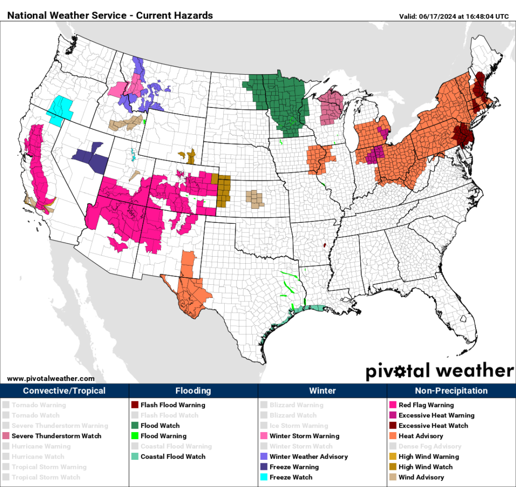
As of this writing Exxon is a major CAT3 in the Northeast looking at the extent of National Weather Service Advisories and rapidly gaining strength. The good news is that most heat advisories have been dropped in the West, but high fire danger remains due to high winds in association with a front:
A near 600 decameter ridge in association with Exxon should build over the Northeast and peak on Wednesday or Thursday:
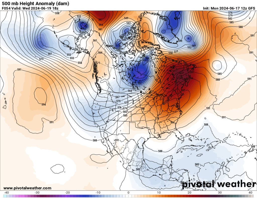
Will we see a record 500 millibar height for June across the Northeast? Stay tuned.
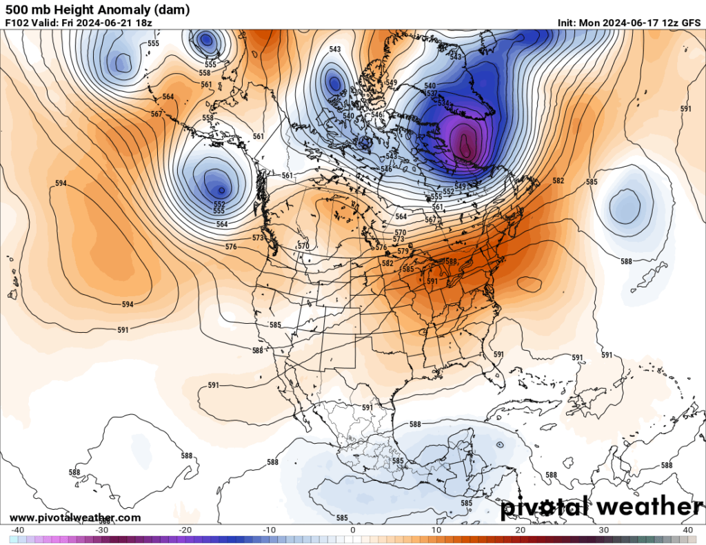
Gradually Exxon’s heat dome will shift south and west and start to decrease by this weekend, allowing the worst of any extreme heat to end across most of the Northeast:
For many more details on Heatwave Exxon’s latest surge, here is a Washington Post article from my buddy, Matthew Cappucci:
Eastern U.S. braces for extreme, long-lasting heat wave: How hot it will get – The Washington Post
Eastern U.S. braces for extreme, long-lasting heat wave: How hot it will get
The Ohio Valley, Northeast and Mid-Atlantic will be particularly hard hit. Heat indexes over 100 will stretch from the Gulf Coast to Canada.

Updated June 17, 2024 at 8:37 a.m. EDT|Published June 16, 2024 at 12:51 p.m. EDT
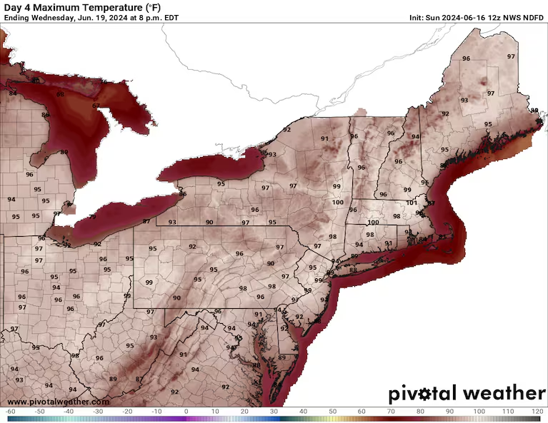
Forecast highs on Wednesday from the National Weather Service. (PivotalWeather)
An exceptional heat wave is about to build into the Midwest, the Northeast and the Mid-Atlantic, with widespread record high temperatures occurring over multiple days. Triple-digit heat index values will stretch from the Gulf Coast to Nova Scotia, representing a combination of dangerous heat and stifling humidity that will be hazardous for vulnerable groups.
The National Weather Service is predicting a “prolonged period of dangerously hot conditions” with “intense heat and high humidity.”
“Heat related illnesses increase significantly during extreme heat and high humidity events,” the agency wrote, “particularly for those working or participating in outdoor activities.”
How bad is heat risk near you?
We’re tracking dangerous heat waves across the United States daily. Look up your city to see extreme heat risks near you.
The heat expanded over the Midwest and South Sunday, with highs of 96 in Chicago and Atlanta and 97 in Little Rock and St. Louis. And that was just a preview of what’s to come.
Highs in the upper 90s to around 100 could reach as far north as southern Canada, with cities such as Boston, Pittsburgh and Washington flirting with 100 degrees as the workweek progresses. Heat index values — which take into account the humidity — will easily top 100 degrees, and could do so several days in a row.
The heat will be exceptional in southeastern Canada and northern New England — setting not only calendar-day records, but also monthly and all-time marks, meaning unsurpassed on any day on record. Highs could exceed normal values by 15 to 25 degrees.
Fort Kent, one of the northernmost cities in Maine and the site of a Canadian border crossing, is predicted to hit 101 degrees Wednesday. Caribou, Maine, could jump to 99, blasting past the city’s all-time record of 96 degrees.
The Weather Service office in Caribou is considering issuing its first excessive heat watch, which can only be hoisted when heat index values are expected to reach 105 degrees on two consecutive days, and overnight temperatures aren’t anticipated to dip below 75 degrees.
The Weather Service office in Burlington, Vt., said the week could bring “the hottest 3-day stretch for some in 30 years.”
Heat advisories and excessive heat warnings cover parts of the Upper Midwest and most of the Ohio Valley and Northeast, affecting about 65 million people. Excessive heat watches are in effect for another 16 million, mainly in in the Northeast.
The unusually long-duration heat wave will expand in coverage and intensify on Monday before dominating Tuesday through Friday. On Saturday, the core of the heat may shift south back into the Mid-Atlantic, including the nation’s capital, which could hit 100 degrees for the first time since 2016. The lengthy spate of heat will itself be a problem, exacerbating heat stress.
Even more impressive is the strength of the instigating “heat dome,” which models indicate will reach a key atmospheric threshold never observed before.
Unsurprisingly, the National Weather Service is highlighting multiple consecutive days of “extreme” heat risk across the Ohio Valley, Mid-Atlantic and Northeast, representing a top-tier level 4 on their 0-to-4 scale.
“This level of rare and/or long-duration extreme heat with little to no overnight relief affects anyone without effective cooling and/or adequate hydration,” the Weather Service wrote.
How hot it will get
Monday
On Monday, things will begin to heat up from roughly Lake Michigan east to Ohio and along the western slopes of the Appalachians. A few 90s may also spill toward the Eastern Seaboard.
- Chicago’s O’Hare International Airport is predicted to hit 95 degrees, falling just shy of the 96-degree record set in 1957. Records there date to 1872.
- Lansing, Mich., is predicted to hit 95 degrees, tying the record set in 1994. Records there date to 1863.
- Toledo is predicted to hit 98 degrees, exceeding the 97-degree record set in 1994. Records there date to 1873.
- Cleveland is predicted to hit 96 degrees, exceeding the 94-degree record set in 2018. Records there date to 1871.
Tuesday through Thursday
The heat dome will reach a punishing crescendo Tuesday through Thursday, with temperatures maxing out near 100 degrees from Illinois to Maine. Interestingly, humidity may be greater in New England than in the Mid-Atlantic region to the south, meaning some of the highest heat index values could be in Massachusetts, New Hampshire, Vermont and Maine.
- Temperatures will reach the mid-90s or so in D.C.; while that will fall just shy of records, heat index values near 100 degrees could be dangerous to older adults and other vulnerable populations.
- In Newark, highs are forecast to reach 97, 99 and 99 degrees on Tuesday, Wednesday and Thursday, respectively. That would tie a record on Tuesday and break records by 5 degrees on Wednesday and 1 degree on Thursday.
- New York City won’t set records, as temperatures will stay in the lower 90s Tuesday and Wednesday, with mid-90s on Thursday. A subtle sea breeze will keep the Big Apple slightly cooler. In the unlikely event that the sea breeze doesn’t make it west to Central Park, the high could reach 96 degrees — which happens during the month of June only 20 percent of the time, according to research meteorologist Tomer Burg.
- Hartford, Conn., is predicted to hit 96 degrees on Tuesday, 99 on Wednesday and 101 on Thursday. All three days would break records. Similar temperatures are expected farther north in the Connecticut River Valley too, and could affect Springfield, Mass.
- Boston’s Logan International Airport probably won’t set any records because it’s located on the immediate coastline, and afternoon sea breezes will probably knock temperatures down by a few degrees. But at the Blue Hill Observatory in Milton, just a few miles inland, highs could reach 98 degrees by Thursday. That would beat the record of 94 set in 1953. Bookkeeping dates to 1893.
- Manchester and Concord, N.H., both in the Merrimack Valley, are predicted to hit 97 degrees on Tuesday and 98 or 99 on Wednesday and Thursday. That will tie or break several records.
- Mid- to upper 90s will be common across Lower Michigan, Ohio, Pennsylvania and New York each day, tying or breaking records in places like Toledo, Columbus and Pittsburgh.
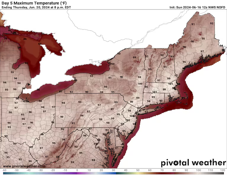
Forecast highs on Thursday from the National Weather Service. (PivotalWeather)
Friday
By Friday, the heat will be focused most intensely from St. Louis and parts of the Midwest and northern Tennessee Valley up the Appalachians and into southern New England, with minor improvement in extreme northern areas. The Interstate 95 corridor in the Mid-Atlantic will be especially hot.
- Louisville is predicted to hit 98 degrees, tying a record set in 1988. Records there date to 1872.
- Pittsburgh is predicted to hit 97 degrees, exceeding the 95-degree record set in 1933. Records there date to 1875.
- D.C., is predicted to hit 98 degrees, just shy of the 99-degree record set in 2012. Records there date to 1872.
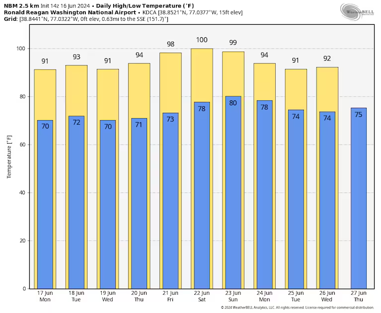
Predicted temperatures for Washington, D.C., over the next 10 days, with highs in yellow and lows in blue, from an average of computer models. (WeatherBell)
- Philadelphia is predicted to hit 99 degrees, tying the record set in 1923. Records there date to 1873.
- Hartford is predicted to hit 97 degrees, exceeding the 96-degree record set in 2012. Records there date to 1905.
The weekend
By Saturday, the greatest actual air temperatures, and chance of breaking records, will become centered on the Mid-Atlantic as the heat dome begins to break down some. But the greatest heat index values, and subsequently the most severe heat risk, may actually be in the Midwest, due to slightly greater moisture.
- Washington Dulles International Airport, west of D.C., is predicted to hit 99 degrees, tying a record set in 1988. Records there date to 1960. Some models are projecting triple-digit highs both weekend days around Washington.
- Georgetown, Del., on the Delmarva Peninsula, is predicted to hit 98 degrees, exceeding the 97-degree record set in 2012. Records there date to 1945.
- Philadelphia is predicted to hit 100 degrees, tying a record set in 1988. Records there date to 1873.
The heat dome
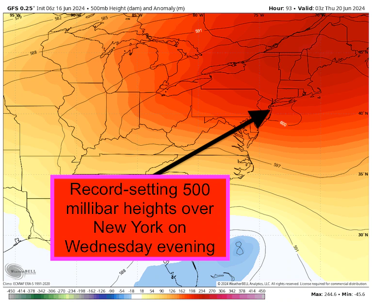
The American GFS model projects record-setting 500 millibar heights over the Northeast on Wednesday evening. (WeatherBell)
Spawning all the heat is a massive heat dome, or ridge of high pressure, that will stagnate for days across the northern U.S. Heat domes are akin to force fields in the atmosphere, deflecting inclement weather. Sinking air warms and dries out, squashing potential cloud cover. The result? Hot, sun-baked air that’s usually cloud-free, which allows for even more dramatic heating.
Warm air expands. If you warmed a balloon, its volume would grow. The same is happening with the atmosphere. The extreme heat is causing the atmosphere to bulge vertically — to a record extent.
Atmospheric scientists look to the “500 millibar level,” or halfway point of atmospheric mass, to see how much an air column has expanded. As far back as records go, that level has never reached 600 dekameters, which is 6,000 meters or 19,685 feet. But that’s probably in the cards this upcoming week.
The American GFS model is indicating that 500 millibar heights could reach 600 dekameters over New York City on Wednesday evening. There has never been a weather balloon launched from New York City/Long Island that has encountered a 500 millibar height greater than 598 dekameters.
There exists a firm link between human-induced climate change and the frequency, intensity and duration of heat events. Heat domes, like this one, are projected to continue becoming more frequent, stronger and more expansive as Earth’s climate warms.
Jason Samenow contributed to this report.
More:
Here are more “ETs” recorded from around the planet the last couple of days, their consequences, and some extreme temperature outlooks, as well as any extreme precipitation reports or outlooks:
Here is some more May 2024 climatology (Prior reports are listed on older daily diary blogs for each calendar day.):
Here is More Climate News from Monday:
(As usual, this will be a fluid post in which more information gets added during the day as it crosses my radar, crediting all who have put it on-line. Items will be archived on this site for posterity. In most instances click on the pictures of each tweet to see each article. The most noteworthy items will be listed first.)