The main purpose of this ongoing blog will be to track planetary extreme, or record temperatures related to climate change. Any reports I see of ETs will be listed below the main topic of the day. I’ll refer to extreme or record temperatures as ETs (not extraterrestrials).😉
Main Topic: U.S. 2024 Record Scoreboard and Climatological Review
Dear Diary. It’s time for our monthly climatological review. Here on this site, we usually present monthly summaries near the 10th of each month, and each is available by clicking the link below:
https://guyonclimate.com/category/record-scoreboard-climatological-reviews
I’m repeating this mantra every month:
The lower 48 states just experienced its warmest year on record thanks to climate change.
The Year 2024 using 1901-2000 mean data got ranked by the National Center for Environmental Information for the lower 48 states as warmest or 130th coolest since records began being kept in 1895 at +3.50°F(1.94°C) above average.
December 2024 using 1901-2000 mean data got ranked by the National Center for Environmental Information for the lower 48 states as 4th warmest or 127th coolest since records began being kept in 1895 at +5.57°F(3.09°C) above average.
The above data was from:
https://www.ncdc.noaa.gov/cag/national/rankings
Seventeen states saw their warmest year on record with the rest having a much above average 2024:

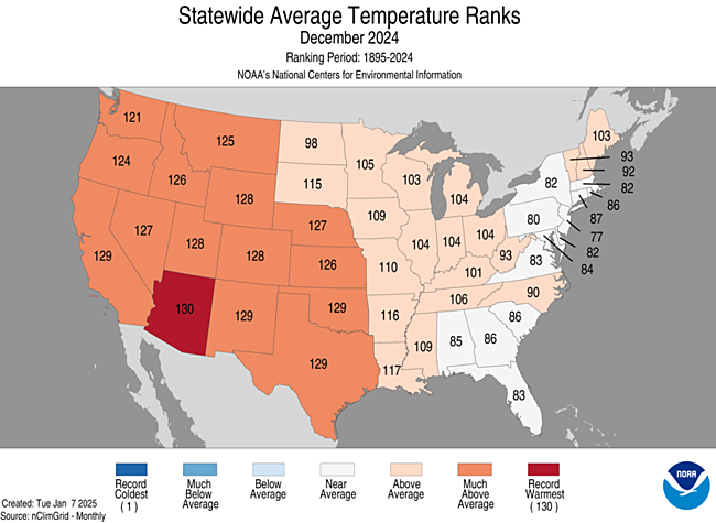
During December 2024 well above average warmth occurred mostly in the western half of the nation. Most reports of record warmth came from the western half of the nation throughout the month. Most reports of record chill came from the Midwest. Arizona saw its record warmest December:
You can check out record totals for yourself on my NCEI record archives:
NCEI Record Count Archive – Guy On Climate
Here are my two U.S. Daily Record Scoreboards updated through 1/08/2025 (data compiled from the following NCEI site):
https://www.ncdc.noaa.gov/cdo-web/datatools/records
I’m also keeping tabs on record report totals to verify a scientific study I helped to complete in the decade of the 2000s. We’ll eventually see how skewed ratios of record warm to cold reports get by the year 2100, which the study mentions as 50-1 for DHMX vs. DLMN:


DHMX= Daily High Max Reports. DLMN= Daily Low Min Reports. DHMN= Daily High Min Reports. DLMX=Daily Low Max Reports.
Boldly highlighted red, blue, or purple colored months, such as December 2023 and June 2021, that have ratios of >10 to 1 daily or <1 to 10 of daily warm to low records are either historically hot or cold, most of which have made news. NCEI rankings are for the lower 48 states with the warmest ranking since 1895 of average temperatures being 130 and 1 being the coldest as of 2024. Blue colors represent cold months and red warm. Those months and years with counts close to a 1 to 1 ratio of highs to lows are colored black. All-time record hottest or coldest months and years are boldly colored in purple. NCDC rankings have been color coded (under tabs in each file) such that values of 54 to 74 are black representing neutral months or years (+ or – 10 from the average ranking of 64).
Totals are record reports for the entire United States including all territories minus those from Alaska. I’ve subtracted those from Alaska to get a better representation of what has occurred across the lower 48 states in association with lower 48 state rankings.
December 2024 had approximately a 32 to 3 (more than 10 to 1) ratio of record DHMX to DLMN individual record counts, so the color I used for that month was bold red on the top chart.
December 2024 had approximately a 15 to 2 ratio of record DHMN to DLMX individual record counts, so the color I used for that month was bold red on the bottom chart.
Due to climate change, we are seeing fewer blue colors on these Record Scoreboards with time.
The average temperature lower 48 state ranking for December 2024 was 127, which was colored red since it was warmer than average. The ranking for the entire year of 2024 was 130, which was colored purple since it was the warmest ranking since 1895.
I color rankings of +10 to -10 from the average ranking for the lower 48 states of 65 black, indicating that these are near average temperature wise. The top warmest ranking for 2024 would be 130 since rankings began in 1895.
Looking at the type and number of record reports, January 2025 has gotten off to a warm start, but that stat is deceiving. An Arctic outbreak has chilled the eastern 2/3rds of the nation while the western third of the country remains much above average. As I write this post historic fires remain a problem in Los Angeles while my hometown of Atlanta is shivering at freezing after a couple of delightful inches of snow fell on the city this morning. Interestingly, the Arctic outbreak logged hardly any daily reports of record chill at all. January 2025 might possibly be a becoming increasingly rare, near average month temperature wise looking at meteorological models, with the West remaining warm and the Midwest chillier than average.
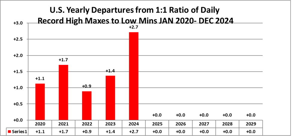
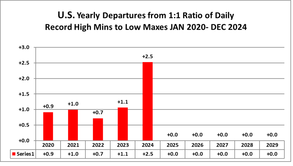
Interestingly, overall ratios for 2024 were higher than historic yearly ratios for other years from the 2020s as shown here…which is no surprise given how hot the globe was during this record hot year thanks to climate change:
We now have another five years of completed data as of DEC 2024. Here is what we see at five-year increments going as far back as possible to 1880:
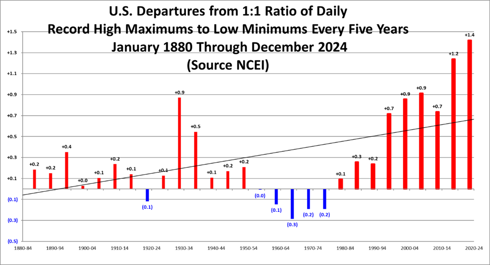
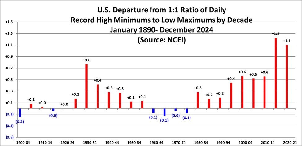
Record ratios are a good reflection of overall average warmth for any given country, and this is indeed what occurred for the United States:
Here is much more detailed climatology for the year 2024 as complied by NOAA:
https://www.ncei.noaa.gov/news/national-climate-202413
Assessing the U.S. Climate in 2024
2024 was the warmest year on record for the contiguous U.S.; Hurricane Helene was the seventh-most-costly Atlantic hurricane on record

Image Courtesy of Jake Fortune, NOAA NCEI
Published
January 10, 2025
Key Points:
- The average annual temperature of the contiguous U.S. was 55.5°F, 3.5°F above average and the warmest in the 130-year record.
- Annual precipitation for the contiguous U.S. was 31.58 inches, 1.66 inches above average, ranking in the wettest third of the historical record (1895–2024).
- The Atlantic basin saw 18 named tropical cyclones and five landfalling hurricanes during 2024—an above-average season. Hurricane Helene was the seventh-most-costly Atlantic hurricane on record.
- The tornado count for 2024 was second highest on record behind 2004 (1,817 tornadoes) with at least 1,735 confirmed tornadoes. When looking at EF-2+ tornadoes, 2024 was the most active year since the historic 2011 season.
- Hurricane Helene’s extensive damage topped the list of 27 separate billion-dollar weather and climate disaster events identified during 2024—the second-highest annual disaster count in the 45-year record.
- Drought coverage across the contiguous U.S. ranged from a minimum extent of 12 percent on June 11—the smallest contiguous U.S. footprint since early 2020—to a maximum coverage of 54 percent on October 29.

Other Highlights:
Temperature

For the year, temperatures were much-above average across nearly the entire contiguous U.S., with record warm temperatures across parts of the Southwest, Deep South and from the Upper Midwest to the central Appalachians and into the Northeast. Seventeen states (Texas, Oklahoma, Minnesota, Wisconsin, Michigan, Indiana, Ohio, Kentucky, Tennessee, West Virginia, Virginia, Pennsylvania, Maryland, New York, Vermont, New Hampshire and Maine) ranked warmest on record while all but two remaining states across the Lower 48 ranked as one of the warmest five years on record. The U.S. Climate Reference Network (USCRN) also indicated that 2024 was the warmest year on record (2005–24).

The Alaska January–December temperature was 28.9°F, 2.9°F above the long-term average, ranking in the warmest third of the 100-year record for the state. Much of the state had temperatures that were above average for the 12-month period with pockets of near average conditions in the southern and eastern mainland as well as the Panhandle.
Precipitation

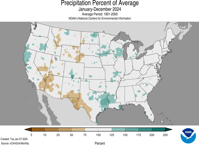
Precipitation was above average across portions of the West, central Rockies, Deep South, Upper Midwest, Great Lakes, Southeast and Northeast. Precipitation was below average across much of the Northern Rockies and Plains, parts of the Southwest and portions of the Ohio Valley and Mid-Atlantic region. Louisiana ranked 10th wettest for this 12-month period.
January–December 2024 ranked near the middle of the 100-year record for Alaska, with below-average precipitation observed across parts of the Aleutians, Northwest Gulf, Cook Inlet, Northeast Gulf and much of the Panhandle region. Average- to above-average precipitation occurred throughout much of the rest of the state.
Billion-Dollar Weather and Climate Disasters

The Billion-Dollar Weather and Climate Disasters update is a quantification of the weather and climate disasters that in 2024 led to more than $1 billion in collective damages for each event. During 2024, the U.S. experienced 27 weather and climate disasters each incurring losses that exceeded $1 billion. 2024 ranked second highest for the number of billion-dollar disasters in a calendar year. These disasters included: 17 severe storms, five tropical cyclones, two winter storms, one flooding event, one drought/heat wave and one wildfire event.
The U.S. cost for these disasters in 2024 was $182.7 billion and was fourth highest on record. The total annual cost may rise by several billion as additional costs from identified events are reported over time. There were at least 568 fatalities associated with these events—the eighth-highest number of fatalities on record. The costliest events in 2024 were:
- Hurricane Helene was the costliest event in 2024. It made landfall as a Category 4 storm in the Big Bend region of Florida on September 26, caused catastrophic flash flooding and power outages impacting millions of people from Florida to North Carolina and resulted in at least 219 fatalities. Helene was the deadliest Atlantic hurricane since Maria (2017) and the deadliest to strike the U.S. mainland since Katrina (2005). The current estimated total cost of this disaster was $78.7 billion.
- Category 3 Hurricane Milton made landfall near Tampa, Florida on October 9, caused widespread power outages and flooding and spawned tornadoes across the state. The current estimated total cost of this disaster was $34.3 billion.
Over the last 10 years (2015–24), 190 separate billion-dollar disasters have killed at least 6,300 people and cost approximately $1.4 trillion in damage.
This is also a record 14th consecutive year where the U.S. experienced 10 or more billion-dollar disasters and the fifth consecutive year (2020–24) where 18 or more billion-dollar disasters impacted the U.S.
Since records began in 1980, the U.S. has sustained 403 separate weather and climate disasters where overall damages/costs reached or exceeded $1 billion (based on the CPI adjustment to 2024) per event. The total cost of these 403 events exceeds $2.915 trillion.
Tropical Cyclones
Record- to near-record sea surface temperatures in the Atlantic basin helped fuel the active season that formed 18 named tropical systems during 2024. Eleven of these storms were hurricanes (tied with 1995 for fifth highest on record), including five that intensified to major hurricanes (tied with 1995, 1999, 2008 and 2010 for sixth highest), two of which were Category 5 storms. Five of these 11 hurricanes made landfall in the U.S. (tied with 1893, 2004 and 2005 for fourth highest) and include: Hurricanes Beryl, Debby, Francine, Helene and Milton. Hurricane Helene was the seventh-most-costly Atlantic hurricane on record.
Tornadoes
As the Storm Prediction Center continues to confirm the tornadoes that occurred during 2024, the current count is 1,735, which is the second-highest number of confirmed tornadoes on record (2004 had 1,817) and 142 percent of the 30-year (1991–2020) average of 1,225. Four EF-4 tornadoes were confirmed during 2024 and occurred in: Elkhorn, Nebraska (April 26), Marietta, Oklahoma (April 27), Barnsdall, Oklahoma (May 6) and Greenfield, Iowa (May 21).
Wildfires
The number of wildfires in 2024 was approximately 90 percent of the 20-year (2001–20) average with more than 61,000 wildfires reported over the year. The total number of acres burned from these wildfires—8.8 million acres—was 26 percent above the 20-year average of nearly seven million acres. The Park Fire, the fourth-largest wildfire in California history, burned nearly 430,000 acres and destroyed over 600 structures.
Alaska saw a below average wildfire year, with approximately 667,000 acres burned during the 2024 fire season—about two-thirds of the state’s seasonal average.
Drought
The year began with approximately 33 percent of the contiguous U.S in drought. Drought coverage shrank as the year progressed and reached the minimum extent for the year at 12 percent on June 11—the smallest contiguous U.S. drought footprint since early 2020. As the summer progressed, hot and dry conditions led to the expansion of drought across the Southeast and Mid-Atlantic as well as across the Plains. By October 29, the extent of drought peaked for the year with more than half of the contiguous U.S. (54 percent) in drought, covering significant portions of the Northwest, Southwest, northern and central Rockies, Plains, Great Lakes, the western and central Gulf Coast states as well as the central Appalachians, Mid-Atlantic and portions of the Northeast.
Snowfall
The 2023–24 snow season was above average across the southern Cascades, Sierra Nevada, Bitterroots, central and southern Rockies as well as portions of the Adirondack, Green and White mountains in the Northeast. Seasonal snowfall was at least three or more feet below average across parts of the northern Cascades, northern Rockies, the northern Plains as well as much of the Great Lakes and Northeast.
The 2024–25 snowfall season to-date from October 1–December 31, 2024 saw above-average snowfall for locations along the West Coast impacted by early-season atmospheric river events. This includes much of the Cascades, northern Sierra Nevada range, Bitterroots as well as the highest elevations of the central Rockies and adjacent Plains along with locations downwind of the Great Lakes. Snowfall deficits prevailed across the southern Sierra Nevada range and from the northern Rockies to the Upper Midwest and across portions of New England.
Climate Extremes Index
The U.S. Climate Extremes Index (USCEI) for 2024 was more than double the average value, ranking highest in the 115-year record. Extremes in warm maximum and minimum temperatures were both highest on record and the primary contributors to this elevated USCEI value for the nation as well as the regions. In addition, all nine climate regions’ USCEI values ranked in the top-10 percent of extremes. Annual extremes across the Southeast and South regions were highest and second highest on record, respectively, and can also be attributed to extremes in one-day precipitation. Near-record extremes across the Upper Midwest were also due to elevated extremes in one-day precipitation and ranked third highest. Across the Northeast, wet Palmer Drought Severity Index (PDSI) values and the number of days with precipitation were elevated and across the Northwest, extremes in one-day precipitation and days with precipitation contributed to the much-above average USCEI values for 2024. The USCEI is an index that tracks extremes (falling in the upper or lower 10 percent of the record) in temperature, precipitation, drought and landfalling tropical cyclones across the contiguous U.S.
This annual summary from NOAA National Centers for Environmental Information is part of the suite of climate services NOAA provides to government, business, academia and the public to support informed decision-making. For more detailed climate information, check out our comprehensive Annual 2024 U.S. Climate Report. For additional information on the statistics provided here, visit the Climate at a Glance and National Maps webpages.
Related Links
Annual 2024 U.S. Climate Report
National Temperature and Precipitation Maps
Climatological Rankings Explained
State of the Climate Summaries
Much More:
Here are more “ETs” recorded from around the planet the last couple of days, their consequences, and some extreme temperature outlooks, as well as any extreme precipitation reports:
Here is some brand new 2024 climatology. More reports are archived on prior January 2025 posts:
Many more notes about the Southern California fires:
Here is More Climate News from Friday:
(As usual, this will be a fluid post in which more information gets added during the day as it crosses my radar, crediting all who have put it on-line. Items will be archived on this site for posterity. In most instances click on the pictures of each tweet to see each article. The most noteworthy items will be listed first.)