The main purpose of this ongoing blog will be to track planetary extreme, or record temperatures related to climate change. Any reports I see of ETs will be listed below the main topic of the day. I’ll refer to extreme or record temperatures as ETs (not extraterrestrials).😜
Main Topic: Looking Forward to Prevent More Katrina Disasters
Dear Diary. Yesterday was Katrina’s 20th anniversary landfall, which we delved into at length. The system peaked at a CAT5 but decayed to a CAT3 before smashing into the central Gulf Coast. Still, at a CAT3 Katrina was powerful enough to bust New Orlean’s levee system, flooding the city, which caused most of the over 1,400 fatalities attributed to the hurricane.
So, what if eventually New Orleans gets the opposite effect…an offshore CAT3 powering up to a CAT5? Will New Orlean’s levee system hold in that eventuality? Climate change is increasing the chances for that scenario. We have recently seen a CAT5 in Michael pounding the Florida Panhandle, devastating Mexico Beach, which did ramp up significantly before a Gulf Coast landfall. Interestingly, Michael was a late season system, having made landfall on October 10th…another aspect of climate change, which extends the active tropical system further into the fall.
Dr. Jeff Masters has written a second post addressing the current state of New Orlean’s levee system in association with more aggressive climate changed influenced hurricanes, which is today’s featured article:
What happens to New Orleans’ levees when a Category 4 hurricane hits? » Yale Climate Connections
What happens to New Orleans’ levees when a Category 4 hurricane hits?
The city’s $23 billion levee system is only rated to withstand a Cat 3.

by Jeff Masters August 29, 2025
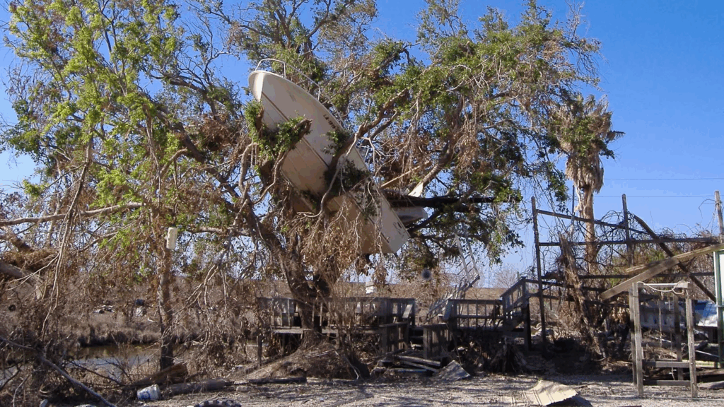
The aftermath of Katrina. Boats strewn about by Katrina. (Image credit: Collection of Wayne and Nancy Weikel, FEMA Fisheries Coordinators, NOAA photo library)
Hurricane Katrina’s impact on the Gulf Coast 20 years ago today met the definition of a catastrophe. At least 1,352 people were killed, making it the deadliest U.S. hurricane in 77 years. It was also the costliest weather disaster in world history with inflation-adjusted damages of $201 billion. In the wake of Katrina’s unthinkable devastation, Congress approved a $14.6 billion ($23 billion in today’s dollars) upgrade to the city’s flood defenses — the Hurricane and Storm Damage Risk Reduction System , or HSDRRS, a 139-mile system of levees, walls and gates designed to protect against a 1-in-100-year storm surge (about 15 feet), equivalent to what a Category 3 hurricane would bring.
The new flood defense system underwent its first stern test in 2012, when Hurricane Isaac, a large, slow-moving Category 1 storm with 80 mph winds, brought a storm surge characteristic of a Category 2 storm — 10 feet — to New Orleans. The new flood defenses performed admirably, giving confidence that the city can indeed withstand a 15-foot storm surge of a Category 3.
A second major test occurred on August 29, 2021 – the 16th anniversary of Hurricane Katrina’s landfall – when Category 4 Hurricane Ida made landfall at Port Fourchon, Louisiana, with 150 mph winds and a central pressure of 930 mb. Ida brought a devastating storm surge of nine to 14 feet to Plaquemines Parish, south of New Orleans, overtopping and then breaching a levee in Braithwaite that was not part of the new flood defense system, and flooding hundreds of homes. Water levels of six to nine feet were common along portions of the New Orleans levee system and reached just a few feet below the top of the West Bank HSDRSS levee, but no portions of the system were overtopped.
However, neither of these hurricanes were a greater than 1-in-100-year storm for New Orleans, though Ida was very nearly so — the National Hurricane Center final report on Ida stated that had Ida made landfall a mere 17 miles to the east, closer to New Orleans, storm surge heights against the southern edge of the West Bank HSDRSS levee would have been 5-7 feet higher, overtopping the levee. According to the National Levee Database, this levee protects 246,000 people and $41 billion in assets.
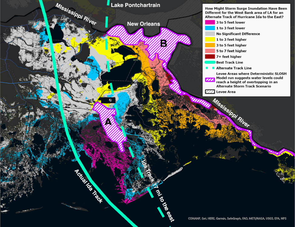
Figure 1. Difference in storm surge inundation produced in southeastern Louisiana to the west of the Mississippi River if Hurricane Ida had moved onshore 17 miles farther east than its actual track. Warm colors depict higher water levels, and cool colors depict lower water levels than what actually occurred. Purple hatched areas depict leveed areas where storm surge overtopping would have occurred with Ida’s shifted track. “A” is the Larose to Golden Meadow Hurricane Protection System; “B” is the West Bank Hurricane and Storm Damage Risk Reduction System (HSDRSS), located along the south bank of the Mississippi River, which protects a portion of New Orleans. (Image credit: NHC)
What happens when the levees get overtopped?
It’s only a matter of time before a hurricane capable of overtopping the levees hits New Orleans, but it’s important to emphasize the difference between levee overtopping and a levee breach. During overtopping, waves from a hurricane storm surge wash over the top of a levee, causing slow inundation of areas behind the levee. If the storm surge is high enough, it won’t be just waves overtopping the levee — the surge itself will push over the top of the levee, causing more rapid inundation. The levee itself remains intact, though.
In the case of a breach, a levee experiences structural failure at its base, allowing flood waters to pour unabated through the gap. A breach is far more serious than overtopping and is more likely to result in high loss of life because inundation occurs rapidly. Very often, overtopping leads to a breach, as the water cascading over the levee accelerates down the slope behind its crest and scours away its base, eroding it. Of the 50 major levee breaches that took place during Hurricane Katrina, all but four were caused by a combination of overtopping and erosion.
In his 2020 book, “Katrina: A History, 1915-2015,” associate professor of history at the University of Connecticut Andy Horowitz references a 2011 Army Corps of Engineers study by Richard J. Varuso titled “USACE Levee Screening Tool.” The report predicted that 974 people would die in New Orleans if a greater than 1-in-100-year storm overtopped the levees; 2,945 would die if the levees were breached.
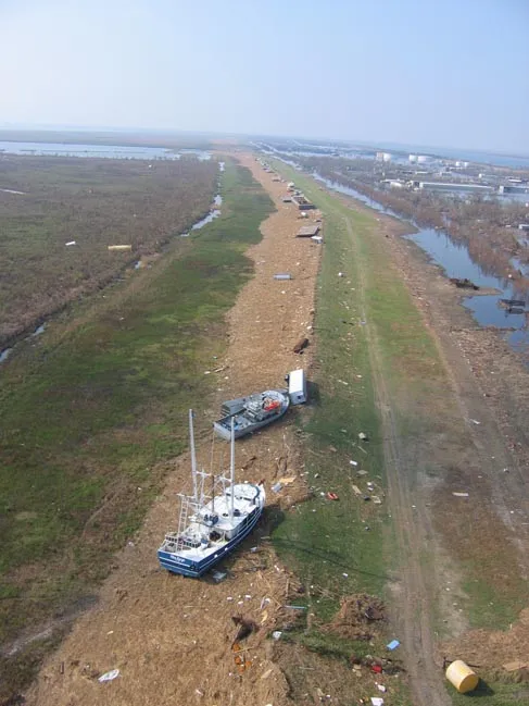
Figure 2. Boats, barges and debris on the levee at Venice. (Image credit: Lieut. Commander Mark Moran, NOAA photo library)
However, that report was written before final upgrades to the levee system. In a project completed in 2021, the U.S. Army Corps of Engineers spent $145 million to armor earthen levees surrounding the New Orleans area to protect against erosion from the overtopping of a storm surge. The Corps partnered with Colorado State University to build a full-scale wave-overtopping simulator to test the erosion resistance of different armoring materials. Meanwhile, the Louisiana State University AgCenter performed multiple tests on different grasses to determine how they would hold up against heavy mowing equipment.
The armor chosen is engineered turf reinforcement mats upon which grass can grow, installed along the inside of key stretches of the levee system. The armor should greatly reduce or eliminate the chances of a levee breach when it is being overtopped by waves, says the Army Corps. They stated that the armoring will mean that the city will just flood to a depth of five feet in an overtopping situation, greatly reducing damage. That’s much lower than the 15-20 feet of inundation that occurred in the lowest locations in New Orleans from the multiple levee breaches and floodwall failures that occurred during Hurricane Katrina. However, we have not yet had a case where a New Orleans levee has been overtopped at an armored section to see if the armor on the protected side of the levee operates as designed, successfully preventing a breach.
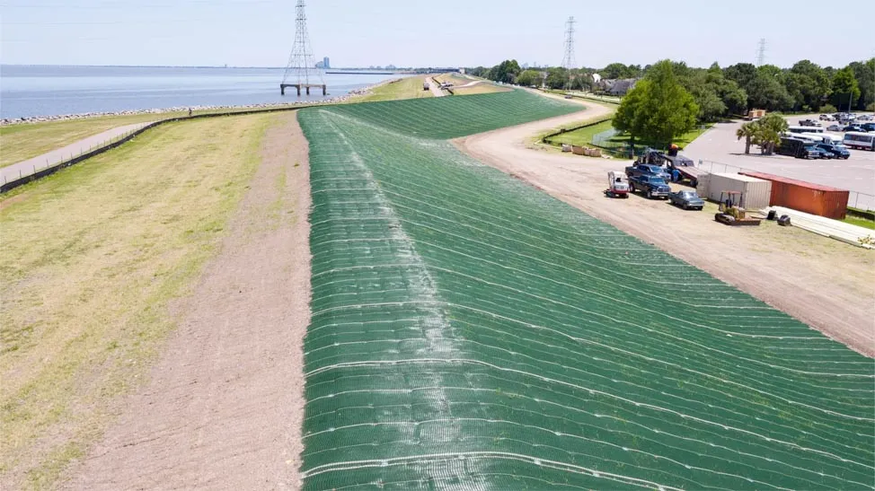
Figure 3. A New Orleans levee armored with one of the products used for over 100 miles of the New Orleans system, PROPEX Armormax, produced by Solmax.com. Photo is from Jefferson Parish, in Kenner past Williams Blvd, west of the Causeway (thanks go to Patrick Pearson for figuring out the photo location).
Two historic hurricanes would likely have overtopped New Orleans’ current levees
The Louisiana coastline has experienced 65 hurricane strikes since 1851, but only one of these hurricanes brought a storm surge to New Orleans likely to have overwhelmed the new levee system, if it behaves as designed. That storm was the 1893 Chenière Caminanda Hurricane, which struck the Mississippi Delta on October 1-2 as a Cat 4 with top winds of 130 mph, bringing a storm surge estimated at 16 feet. It destroyed nearly every structure in the town of Chenière Caminada and killed more than half of its 1,500 residents. With an estimated 1,700-2,000 fatalities, the hurricane ranks as the third-deadliest in continental U.S. history, behind the 1900 Galveston Hurricane and the 1928 Okeechobee Hurricane. Country Roads has more on this tragic storm.
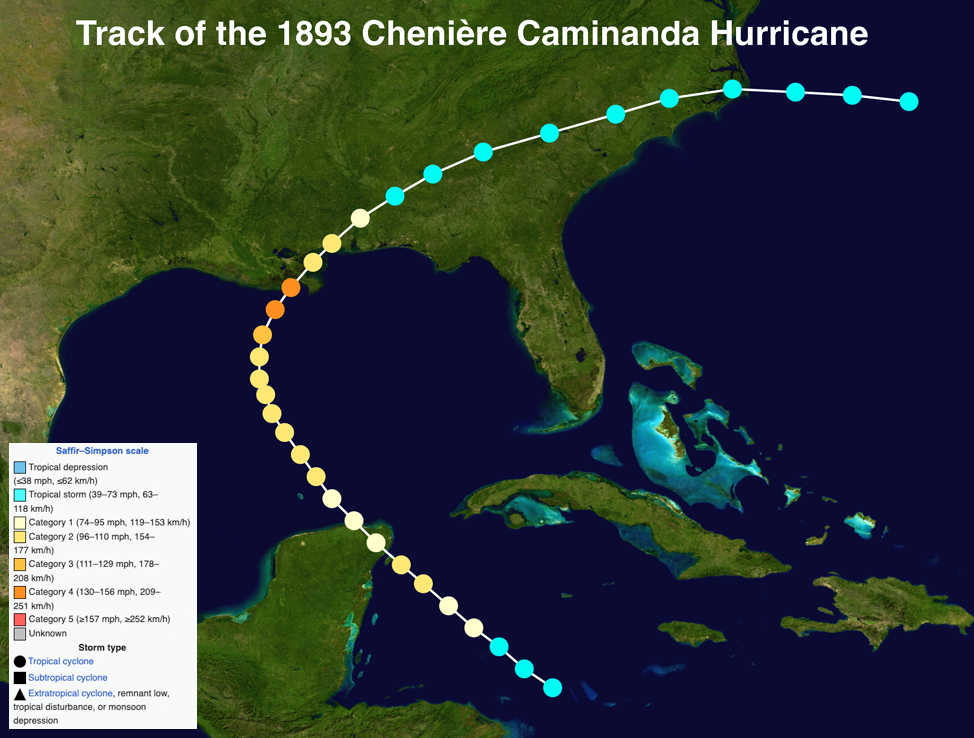
Figure 4. Track of the 1893 Chenière Caminada Hurricane. (Image credit: Wikipedia)
However, it is also possible that an 1812 hurricane, which hurricane researcher Cary Mock suspects was a Category 4, could also have been strong enough to overwhelm the New Orleans levee system.
What happens when a Cat 4 hits New Orleans?
Considering that two historic storms capable of overtopping the levee system have already hit the city, and that climate change is making the strongest hurricanes stronger and raising sea levels, it’s only a matter of time before New Orleans sees the “Big One” that will overtop the city’s levees. Bob Jacobsen, former president of the Louisiana Section of the American Society of Civil Engineers and senior consulting hydrologist to the Southeast Louisiana Flood Protection Authority—East, emphasized to me that unexpected bad things can happen in intense disaster situations. A barge slamming into a flood wall causing a breach would be one example. Furthermore, the system was designed to reduce flood insurance cost, not for rigorous safety certification, and it won’t take a Cat 4 to overtop the levees, he said. He also believes that some portions could breach during a surge exceeding a 1-in-100-year storm, and his main concern was long-duration overflow of portions of the levees with lower freeboard (not built with as much safety margin before being overtopped), such as along the northwestern portion of the city, from the storm surge off of Lake Pontchartrain.
Climate change is increasing the odds of New Orleans levee failures
Climate change is increasing the risk to New Orleans’ levees in two major ways:
1) Rising sea levels will increase storm surge risk
Sea level rise in 2050 at New Orleans’ closest Louisiana tide gauge — at Grand Isle — is predicted to be over two feet by 2050 compared to 2000 levels. (More than half of this relative sea level rise is from sinking of the land, which is primarily from human causes, though.) Accelerating sea level rise will require regular raising of the New Orleans levees to maintain 1-in-100-year protection. This is no easy task when federal money to perform climate change risk reduction is being severely curtailed.
2) The strongest hurricanes will get stronger
Hurricanes are heat engines that take heat energy out of the ocean and convert it to the kinetic energy of their winds. A hotter ocean will allow hurricanes to grow more powerful, assuming that the other factors that power hurricanes, including low wind shear and a moist atmosphere, are present. Climate change theory and computer modeling consistently show that we should expect to see the strongest storms growing stronger, with an increase in the proportion of Cat 4 and Cat 5 hurricanes that occur, as the planet warms.
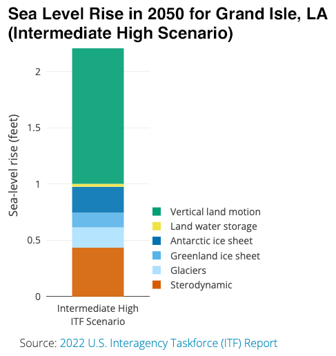
Figure 5. Predicted sea level rise in 2050 compared to 2000 for a station in coastal Louisiana south of New Orleans, under an Intermediate-High scenario. (Image credit: NASA Flooding Analysis Tool)
Huge advancements in hurricane forecasts since 2005
The National Science Board, in a report issued in 2006 in the wake of Hurricane Katrina, found it would be cost-effective to increase hurricane research funding by $300 million per year, compared to the $20 million in annual funding that existed at the time. Some of this funding did happen, with the establishment of the Hurricane Forecast Improvement Program in 2007. Thanks in large part to this wise investment, hurricane track forecasts have seen a huge improvement since Katrina hit in 2005, with forecasts for all lead times improved by 50% or greater (Fig. 6). Intensity forecasts have also improved significantly, by over 30% at all forecast lead times (Fig. 7).
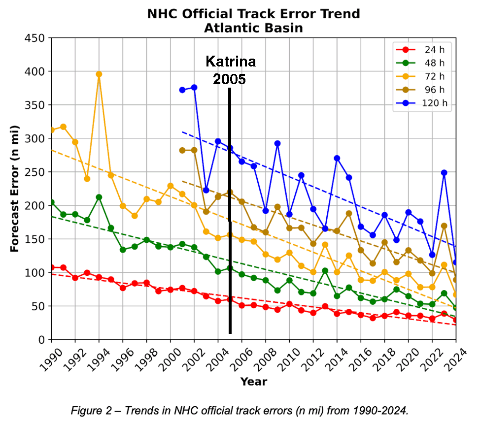
Figure 6. Verification of official NHC hurricane track forecasts for the Atlantic, 1990–2024, from the 2024 NHC Forecast Verification Report. Since 2005, track errors for forecasts at all lead times have improved by over 50%.
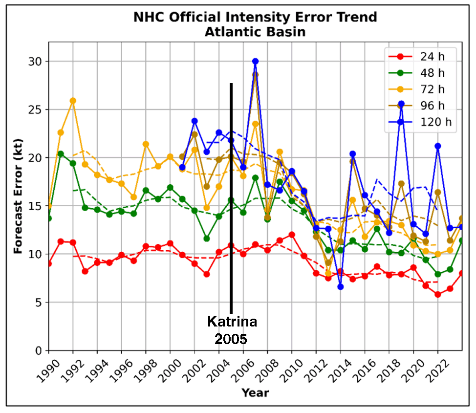
Figure 7. Verification of official NHC hurricane intensity forecasts for the Atlantic, 1990–2024, from the 2024 NHC Forecast Verification Report. Since 2005, intensity errors for forecasts at all lead times have improved by over 30%.
A 2024 study by the nonprofit, nonpartisan National Bureau of Economic Research, “The Social Value of Hurricane Forecasts,” found that advancements in hurricane forecasting since Katrina hit have a huge value: an average cost reduction of $5 billion per major landfalling hurricane over the period 2005-2020. The benefits came either by decreasing deaths and damages or by inspiring confidence in decisions not to spend money on pre-storm adaptation.
Thus, it makes sense to continue our investments in hurricane research, which have brought about these huge advancements in forecast accuracy. But given the multiple losses in forecasting capability that have occurred this year, this progress may halt or even reverse beginning in 2025. This is particularly untimely, since climate change acts to increase the odds of hurricanes that rapidly intensify just before landfall. These are the most dangerous types of hurricanes, as they give people less time to prepare and evacuate. New Orleans needs a full 72 hours to evacuate, and the city may not have that time when the Cat 4 or Cat 5 capable of overpowering their flood defenses finally does arrive.
Read: Climate change brings more rapidly intensifying hurricanes; NOAA cuts makes forecasting them harder
Read: How climate change is making hurricanes more dangerous
Read: Two major ways the Trump administration is making hurricane evacuations more dangerous
Bob Henson contributed to this post.
Jeff Masters
Jeff Masters, Ph.D., worked as a hurricane scientist with the NOAA Hurricane Hunters from 1986-1990. After a near-fatal flight into category 5 Hurricane Hugo, he left the Hurricane Hunters to pursue a… More by Jeff Masters
Jeff Master’s and Bob Henson’s “What happens to New Orleans’ levees when a Category 4 hurricane hits?” was first published on Yale Climate Connections, a program of the Yale School of the Environment, available at: http://yaleclimateconnections.org. This work is licensed under a Creative Commons Attribution-Noncommercial-No Derivative Works 2.5 license (CC BY-NC-ND 2.5).
Here are more “ETs” recorded from around the planet the last couple of days, their consequences, and some extreme temperature outlooks, as well as any extreme precipitation reports:
Here is More Climate News from Saturday:
(As usual, this will be a fluid post in which more information gets added during the day as it crosses my radar, crediting all who have put it on-line. Items will be archived on this site for posterity. In most instances click on the pictures of each tweet to see each article. The most noteworthy items will be listed first.)