The main purpose of this blog will be to track planetary extreme, or record temperatures related to climate change. Any reports I see of ETs will be listed below the main topic of the day. I’ll refer to extreme or record temperatures as ETs (not extraterrestrials).😜
Main Topic: Washington Flood Exacerbated by Climate Change
Dear Diary. As we have witnessed over the past couple of decades, climate change makes wet weather systems wetter, whether they be from hurricanes or in this case atmospheric rivers. A warmer atmosphere holds more moisture, which can be released in torrents by various weather systems.
In the case of flooding that occurred earlier this week in the Pacific Northwest and British Columbia, a record warm air mass developed over the Southwest, which interacted with an atmospheric river that also got strengthened because the jet stream strengthened:

The jet ushering in moisture along the atmospheric river got faster because it got more energy from the heat dome that developed over the Southwest and a portion of the polar vortex extending southward from Alaska. In other words, the gradient represented by height contours in the below Pivotal Weather image tightened much more than usual because of the southwestern heat dome, which is an indication of a faster jet:

For more details on Washington flooding, here is a Washington Post article:
Record moisture leads to destructive flooding in Washington state – The Washington Post
Destructive flooding hits Washington state, with six rivers at dangerous levels
Severe flooding has led to evacuation orders and water rescues. More rain is expected Thursday.
December 11, 2025

From left, deli owners Zahra Hesham, Hanadi Hesham and Karrar Hesham, along with Yousif Hesham, back, walk through floodwaters after checking out their store in Auburn, Washington, on Wednesday. (John Froschauer/AP)
By Joshua Partlow and Ben Noll
MOUNT VERNON, Wash. — An atmospheric river, whose moisture spanned a remarkable 7,000 miles across the Pacific Ocean from the Philippines to the Pacific Northwest, caused record river levels and destructive flooding across Washington state this week and forced thousands to evacuate while authorities wait to see if levees will hold.
According to an analysis of weather data, moisture levels with this storm may have broken December records by as much as 6.7 percent, considering based on records dating back to 1940.
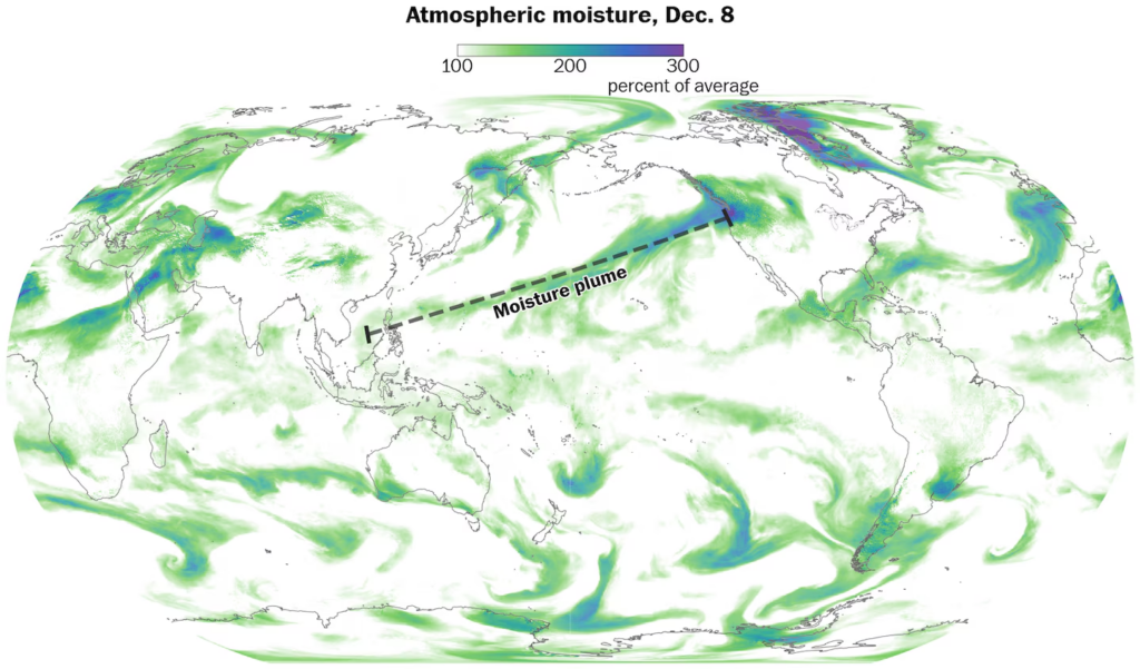
A moisture plume spanning the length of the Pacific Ocean fed into an atmospheric river that soaked the Pacific Northwest this week. (Ben Noll/Data source: ECMWF/ERA5)
This includes portions of Snohomish, King, Chelan and Kittitas counties in Washington, east of Seattle, where more than a foot of rain had fallen in some high-elevation areas in the Cascades since the start of the week. Similar rainfall totals were observed near the Olympic Mountains.
Swaths of the Pacific Northwest are considered hot spots, where rising moisture flows in the atmosphere have frequently driven heavy rainfall.
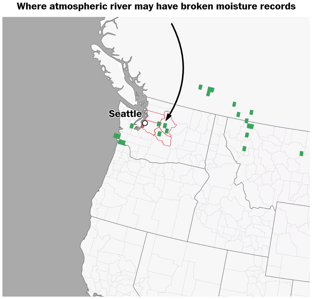
An atmospheric river may have caused record moisture levels in portions of the Pacific Northwest, according to forecasts issued Wednesday compared with historical data since 1940. (Ben Noll/Data source: ECMWF/ERA5)
As of Thursday, parts of six rivers in Washington had reached major flood stage — the highest level on the scale — including the Skagit, Skykomish, Snohomish, Snoqualmie, Cedar and Cowlitz rivers.
The rising floodwaters have forced thousands of people from their homes in western Washington, where the National Weather Service has warned of potentially catastrophic and life-threatening floods.
Dozens of roads and highways have been closed by flooding across wide swaths of the state. Water rescues unfolded near Fall City, Washington, east of Seattle.
One of the main crisis spots on Thursday was along the Skagit River, which flows down from the Cascades north of Seattle and empties into the Puget Sound.
Authorities have called on people within the 100-year-floodplain of the river to evacuate as the still-rising river could peak sometime overnight at record levels, testing a levee system that suffered damage during a 2021 flood. Schools in Skagit County have closed Thursday and Friday.
“This situation is unpredictable, it’s dangerous, we don’t know what exactly will happen when those flood waters come through,” Robert Ezelle, director of Washington state’s emergency management division, told reporters at a news conference on Thursday afternoon at a college in Skagit County.
Authorities are expecting flood waters along the Skagit River in the Mount Vernon area to surpass the record level by two feet, peaking overnight Thursday or Friday morning.
“This system coming through will test the work that was done on the levees,” Ezelle said.
The floods have closed rural highways and cut off mountain towns and caused landslides in wildfire burn scar areas such as in Stehekin, a remote community reachable by boat along Lake Chelan in eastern Washington, authorities said.
In Sedro-Woolley, a city along the Skagit River, residents who live close to the river have scrambled to get out of harm’s way over the past two days. Rebecka and Rafael Perez evacuated from their riverfront RV park on Wednesday and are staying in a hotel to wait out the flood. They came back to the police cordon on Thursday to watch the steadily rising river.
“It’s completely gone,” Rebecka Perez, 50, said of the site of her former home. “It’s completely underwater.”
Many people in Sedro-Woolley remained in the city, with shops and restaurants open downtown. Among the soggy forested foothills, it takes a lot of rain to impress locals. But the scale this time has made many take notice, particularly the warnings that levees and dikes could fail.
“I’ve lived here for 22 years, and I’ve never seen flooding like this,” said Staci Hasenohrl, 40, who lives a few blocks from the evacuation zone but has chosen to stay so far. She said she’s never been scared of flooding before but “my fight-or-flight was pretty high this time watching how high it was supposed to be.”
In Mount Vernon, the swollen and silty Skagit River crept up slowly throughout the afternoon, sweeping along massive trees and clumps of logs. Residents gathered on a riverside bike path to watch the river and take photos and selfies as the debris raced past.
Skagit County commissioner Lisa Janicki warned residents to stay away from the levees and dikes along the river.
“People are walking their dogs on the tops of these dikes that may fail,” Janicki said during the news conference. “We’re hoping they hold. But there’s seepage in some spots.”
“Get off those dikes. Get home. And take care of your loved ones,” she added.
An estimated 78,000 people live in the flood zone along the Skagit River but local authorities said they expected to house about 3,800 evacuees at various shelters in the area.
Washington Gov. Bob Ferguson (D) said he’s asked the Trump administration for an emergency declaration to help support the recovery when the waters recede. Some 100 National Guardsmen have been deployed and 200 more were en route, state officials said.
“It’s a very, very serious situation,” Ferguson said during a news conference on Thursday afternoon.
Rain is forecast to continue across western Washington on Thursday, although its intensity is expected to gradually wane as the core of the atmospheric river pushes northward into British Columbia by Friday. As part of the same weather system, heavy snowfall is forecast across southern Alberta and Montana on Friday.
Dry weather is forecast across Washington for Saturday, although more heavy rain is expected from Sunday into early next week — as a new atmospheric river joins forces with the current one, sending copious amounts of moisture into the region.
Another atmospheric river is forecast to hit the Pacific Northwest early next week. (Video: Ben Noll/Data source: ECMWF)
Extreme weather
- Winter is coming. Not all weather offices are ready.December 8, 2025
- Back-to-back winter storms will soon hit the Midwest and NortheastNovember 28, 2025
- Why this ‘weird’ U.S. hurricane season is still a troubling oneNovember 18, 2025

By Joshua Partlow Joshua Partlow is a reporter on the The Washington Post’s national desk. He has served previously as the bureau chief in Mexico City, Kabul, Rio de Janeiro, and as a correspondent in Baghdad. follow on X@partlowj

By Ben Noll Ben Noll is a meteorologist passionate about explaining the why behind the weather, extreme events and climate trends. He has expertise in data analysis, supercomputer-driven graphics and forecasting weather worldwide. follow on X@BenNollWeather
Here are some “ETs” recorded from around the planet the last couple of days, their consequences, and some extreme temperature outlooks, as well as any extreme precipitation reports:
Here is More Climate News from Friday:
(As usual, this will be a fluid post in which more information gets added during the day as it crosses my radar, crediting all who have put it on-line. Items will be archived on this site for posterity. In most instances click on the pictures of each tweet to see each article. The most noteworthy items will be listed first.)