The main purpose of this ongoing blog will be to track planetary extreme, or record temperatures related to climate change. Any reports I see of ETs will be listed below the main topic of the day. I’ll refer to extreme or record temperatures as ETs (not extraterrestrials).😜
Here is a new feature for this blog, which I will add daily. This is the latest inciteful Green News Report from my friends Desi Doyen and Brad Friedman at Progressive Voices. Hit ‘continue reading,’ listen, then hit return to see my daily topics:
Main Topic: The advent of Heatwave ConocoPhillips
Dear Diary. If you have been reading my posts from the past week you will note that I first mentioned the possibility of another major heatwave occurring across portions of the United States on Monday:
It didn’t take too long before a relatively minor heatwave that started early this week in the West to morph into a monster that I named Heatwave ConocoPhillips yesterday:
The heat dome in association with Heatwave ConocoPhillips will break records across the northern Plains. It looks like it will peak out around 600 decameters near Minneapolis early on Tuesday:
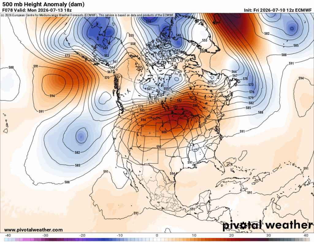
Within my heatwave categorization criteria, I state that a historic CAT4 heatwave must set numerous all-time records and/or kill 500-1000 people. I have no doubt that Heatwave ConocoPhillips will set numerous all-time records. Fortunately, enough air conditioning infrastructure has been built across the Plains and Intermountain West to prevent over 500 deaths, but we will see what temperatures approaching 110°F do in some locations there.
Here are more details from the Washington Post:
Heat dome to break records in drought-hit states; temps could reach 110 – The Washington Post
Heat dome to topple records in drought-stricken Plains and Western states
See where temperatures could reach a rare 110 degrees and amplify fire weather risks.
July 10, 2026

By Ben Noll
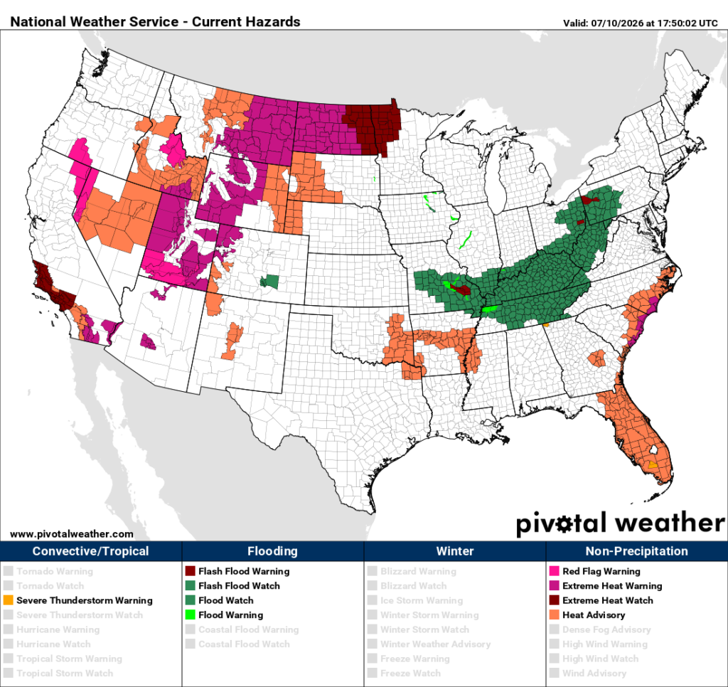
33 million Americans were covered by these alerts from the National Weather Service as of 5 a.m. EDT on Friday
Another heat dome is coming. And it’s about to elevate fire risks and topple temperature records, with heat and/or fire weather alerts in effect for around 33 million people living in stretches of Western and Central states as of early Friday.
This heat dome will first sizzle drought-stricken parts of the Intermountain West this weekend before expanding into the northern Plains and Upper Midwest next week.
The National Weather Service in Salt Lake City, which serves most of Utah, called it “the most significant heat wave thus far this season” in a forecast discussion, writing that monthly temperature records will be challenged this weekend. It’s forecast to reach 106 degrees in Salt Lake City on Sunday, which would tie for the city’s second-highest temperature on record since records began in 1874.
Farther north, temperatures could reach 110 degrees in parts of Idaho, Montana and Wyoming, challenging all-time temperature records in some places, such as Billings, Montana, on Sunday — where it could be hotter than Phoenix.
By Monday, the Dakotas will be underneath the planet’s most powerful heat dome, with temperatures easily eclipsing 100 degrees for many — and potentially pushing toward 110 degrees for some, such as people near Rapid City in South Dakota.
And from Monday to Wednesday, temperatures in the stretch from Denver to Minneapolis are forecast to reach well into the 90s.
These hot, dry and windy conditions are expected to increase fire weather risks across the interior West — where drought conditions are worst — and to a lesser extent, California.
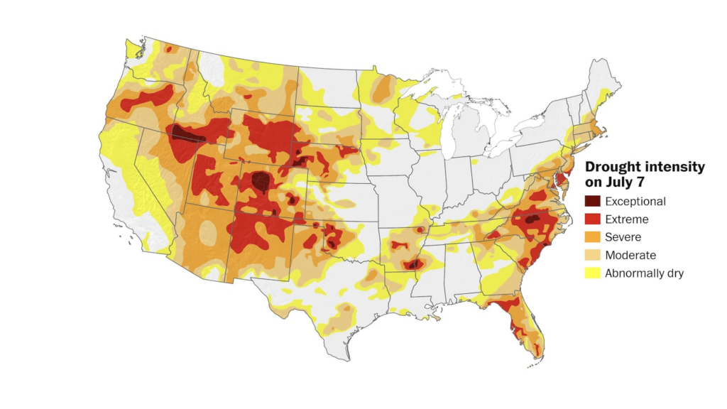
Severe to extreme drought covers many areas that will be scorched by a heat dome this weekend into next week, raising fire weather concerns. (Ben Noll/The Washington Post; USDM)
In a live stream on Thursday, climate scientist Daniel Swain discussed his concerns for lightning-ignited fires. These fires can take a day or two to show themselves, he said, with trees and bushes smoldering “quietly” after being struck by lightning before turning into an active fire once conditions warm up and dry out.
“I would not at all be surprised to see these risk areas expanded or upgraded from elevated to critical,” he said when discussing fire weather outlooks across the Intermountain West through this weekend.
This developing heat dome is the latest in a string of similar events that have recently scorched Europe and the U.S. East Coast.
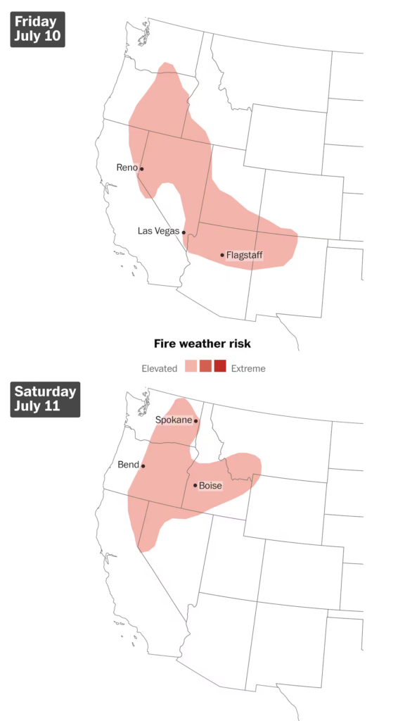
There is elevated fire weather risk across the Intermountain West into the weekend as hot, dry and windy weather builds. (Ben Noll/The Washington Post; NOAA/SPC)
The formation of this heat dome can be linked to a building El Niño, which is contributing to stormy weather — including a dangerous typhoon — in parts of the Pacific. That has ripple effects on the jet stream. That ribbon of fast-moving air in the upper atmosphere will form a ridge of high pressure in the West and Plains to compensate for unsettled conditions elsewhere.
But climate change is raising the bar on heat dome intensity, which can create more dangerous conditions — especially when combined with excessive humidity levels, which have risen in recent decades, as well as unusually warm nights.
As the core of the heat dome shifts into the Central U.S. next week, some monsoonal moisture will probably flow into the West, increasing the chance for scattered rain and thunderstorm activity.
“By the time we get to mid and late July, there is some good news here, which is that it does look like there are better odds that there is going to be a moister air mass across the West,” Swain added.
Here are some “ETs” recorded from around the U.S. the last couple of days, their consequences, and some extreme temperature outlooks, as well as any extreme precipitation reports:
Here is More Climate News from Tuesday:
(As usual, this will be a fluid post in which more information gets added during the day as it crosses my radar, crediting all who have put it on-line. Items will be archived on this site for posterity. In most instances click on the pictures of each tweet to see each article. The most noteworthy items will be listed first.)